Narrow Results By
Subject
- Agricultural Tools and Equipment 5
- Agricultural Tools and Equipment - Cultivators 1
- Agricultural Tools and Equipment - Gardening Equipment 2
- Agriculture 3
- Agriculture - Dairy 2
- Agriculture - Farms 2
- Agriculture - Fruit and Berries 2
- Animals 1
- Building Components 1
- Buildings - Agricultural 4
- Buildings - Agricultural - Greenhouses 2
- Buildings - Agricultural - Stables 1
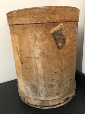
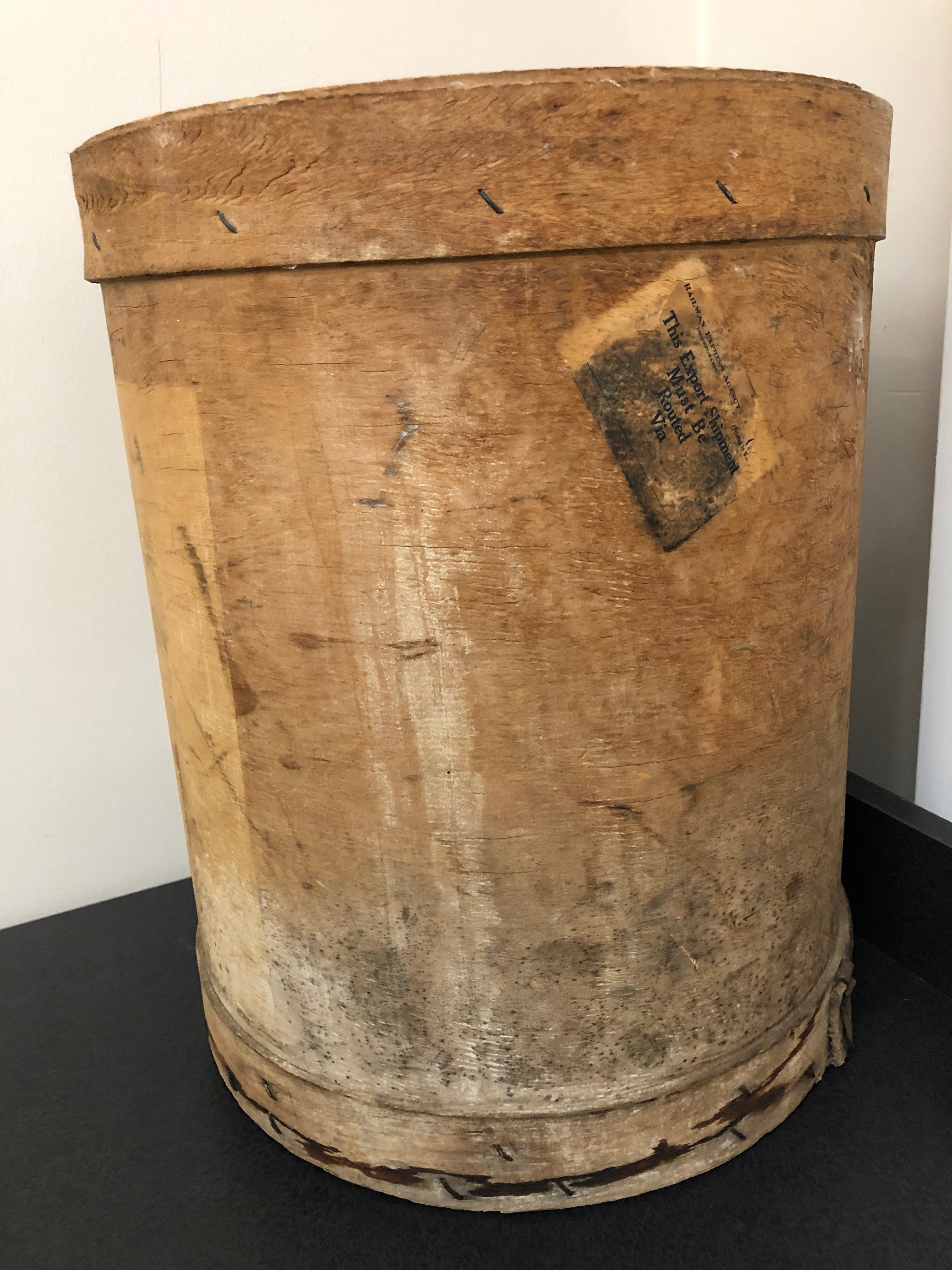
Barrel
https://search.heritageburnaby.ca/link/museumartifact90555
- Repository
- Burnaby Village Museum
- Accession Code
- BV020.22.1
- Description
- Cylindrical veneer mushroom spawning barrel. The wood has been shaped to make the barrel. There is a base and rim around the top and bottom of the barrel, stapled to hold it together. There are a number of stains, discolourations, ink, and evidence of past mold. There is also a lid with a metal ring afixed to it. The lid has the name "Stiglish" handwritten with a circled number "2". In black ink, a stamp reads: Fraser Valley Mush Grow.Co-op Assn.265 E. Georgia St. Vancouver, B.C. Canada"
- Object History
- Used on the Stiglish family mushroom farm
- Category
- 04.Tools & Equipment for Materials
- Classification
- Agricultural T&E - - Cultivation Equipment
- Object Term
- Barrel
- Marks/Labels
- Railway Express Agency Incorporated / Printed in U. / This Export Shipment Must Be Routed Via
- Colour
- Brown
- Gray
- Black
- Measurements
- 14" in diameter and 17" high
- Historic Neighbourhood
- Burquitlam (Historic Neighbourhood)
Images

Big Bend Neighbourhood
https://search.heritageburnaby.ca/link/landmark840
- Repository
- Burnaby Heritage Planning
- Associated Dates
- 1955-2008
- Heritage Value
- The Big Bend Neighbourhood in Burnaby maintained its status as an important agricultural area in the City in the years following 1955 and it also solidified its role as a prime industrial and commercial district. In 1972, the Big Bend Development Plan was adopted by Council and soon thereafter, approximately 620 acres of land were incorporated into the Agricultural Land Reserve. These lands have been set aside for agricultural and limited recreation purposes. By the 2000s, 160 acres of land were considered highly productive agricultural areas, and over 400 acres of land had been secured as parkland, including the Fraser Foreshore Park. The area also developed large commercial and industrial districts including those at Marine Way/Boundary, the Glenlyon Estates, Riverfront Business Park, Burnaby Business Park, and Glenwood Industrial Estates.
- Historic Neighbourhood
- Fraser Arm (Historic Neighbourhood)
- Planning Study Area
- Big Bend Area
Images

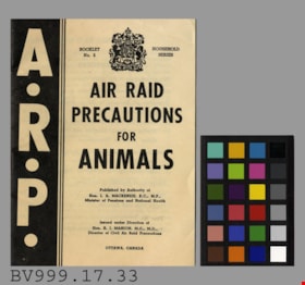
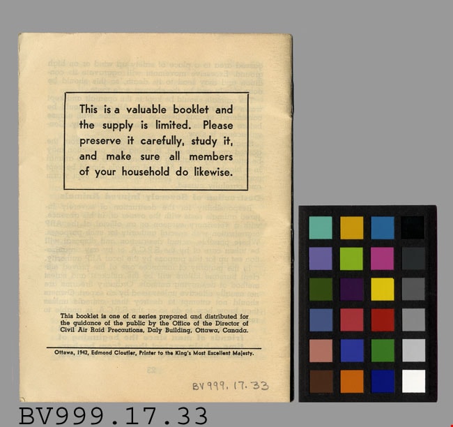
booklet
https://search.heritageburnaby.ca/link/museumartifact39858
- Repository
- Burnaby Village Museum
- Accession Code
- BV999.17.33
- Description
- Air Raid Precautions for Animals - Booklet -- [1942]. Booklet 5, part of the Air Raid Precautions House Hold Series; 23 p.; stapled spine. The booklet provides information on what to expect if an air raid occurs and how to care for both urban and agricultural animals during an attack. The booklet was published by the authority of Hon. J.A. MacKenzie, Minister of Pensions and National Health in accordance with the Civil Air Raid Precautions. The booklet issued under the direction of Hon. R. J. Manion, Director of Civil Air Raid Precaustions and was printed in Ottawa by Edmond Cloutier "Printer to the King's Most Excellent Majesty" in 1942.
- Object History
- Item was referred to by Harry Cutress who was a volunteer with the Burnaby Air Raid Precautions in South Burnaby during the 1940s.
- Category
- 08. Communication Artifacts
- Classification
- Documentary Artifacts - - Instructional Documents
- Object Term
- Book, Instruction
- Measurements
- 11.5cm x 15.5cm.
- Maker
- Edmond Cloutier
- Country Made
- Canada
- Province Made
- Ontario
- Site/City Made
- Ottawa
- Publication Date
- 1942
- Subjects
- Documentary Artifacts
- Documentary Artifacts - Booklets
- Animals
- Wars
- Wars - World War, 1939-1945
- Emergency Measures - Civil Defence
Images


Box
https://search.heritageburnaby.ca/link/museumartifact89918
- Repository
- Burnaby Village Museum
- Accession Code
- BV019.6.1
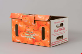
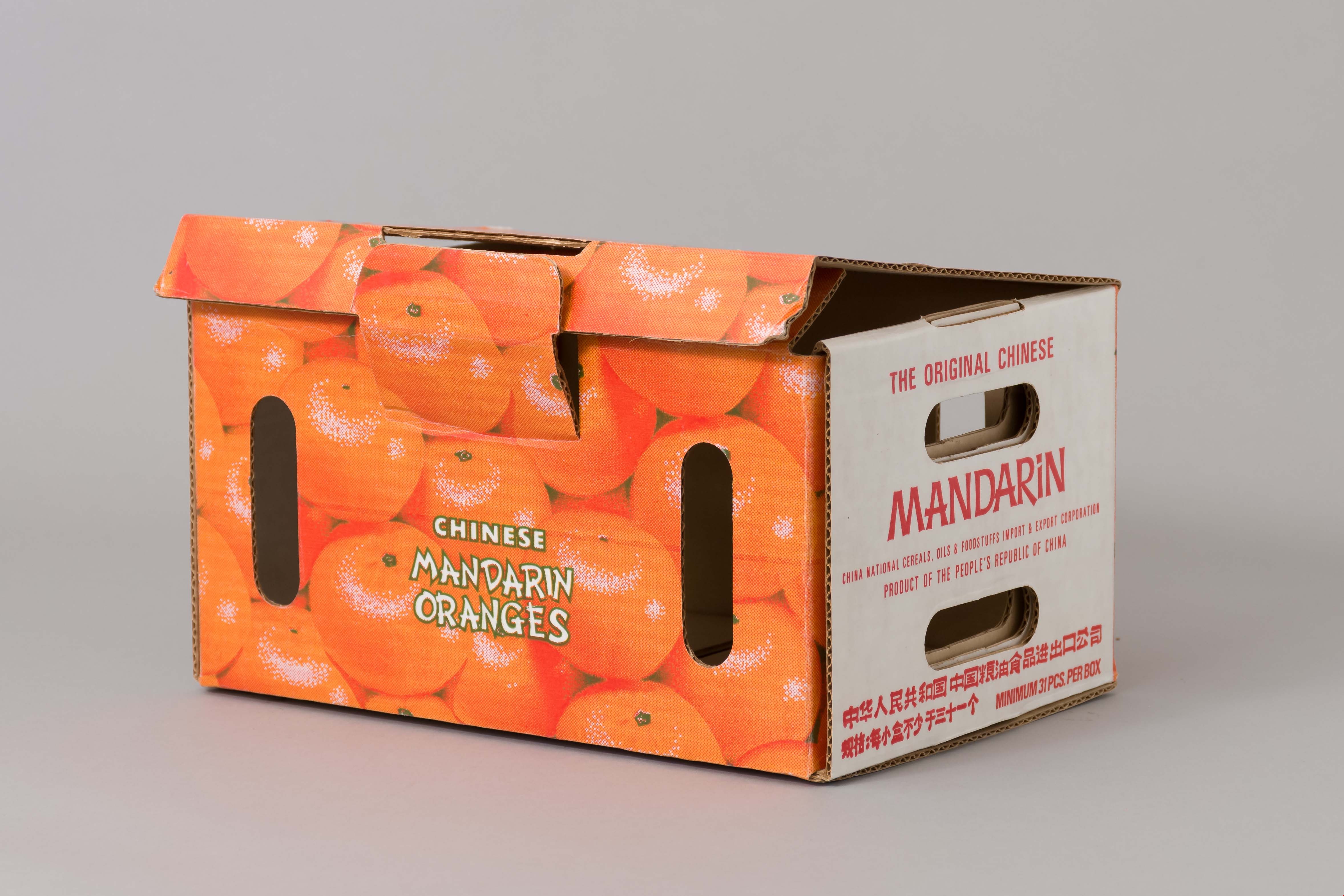
- Description
- box; to ship and sell mandarin oranges; rectangular, corrugated cardboard box; single piece of cardboard, folded to form box; locking tab lid; oval cut outs in sides and lid for air circulation and for carrying; interior is plain brown cardboard; exterior has white, orange, and green text and illustrations beneath a wax coating. Colourful illustrations of mandarin oranges on sides and lid of box; text on front, back, and lid reads: "CHINESE / MANDARIN / ORANGES"; text on one side in French and other side in English reads: "THE ORIGINAL CHINESE / MANDARIN / CHINA NATIONAL CEREALS, OILS & FOODSTUFFS IMPORT & EXPORT CORPORATION / PRODUCT OF THE PEOPLE'S REPUBLIC OF CHINA / [text in Chinese] / MINIMUM 31 PCS. PER BOX"."
- Object History
- As a produce buyer for Kelly Douglas, Cecil Lee worked closely with local farmers along Marine Drive and in the Fraser Valley. The Burnaby company was one of the largest food distributors in Canada. In the mid-1970s, Lee was asked to oversee the import of Chinese mandarin oranges into Canada. Until that time, mandarin oranges had come from Japan and were sold in the winter, especially at Christmas. When the Japanese market could no longer keep up with demand, Kelly Douglas looked to China. The company relied on Lee’s cultural knowledge to build this very profitable part of their business. Lee designed the cardboard Chinese mandarin orange box to replace wooden containers. The iconic design required no glue or staples, making it possible for farmers to assemble and pack the boxes as they picked the oranges.
- Reference
- For other records in this collection see: Business records series of Julie Lee and Cecil Lee family fonds
- Category
- 04.Tools & Equipment for Materials
- Classification
- Food Processing & Preparation T&E - - Food Storage Equipment
- Object Term
- Box, Food Storage
- Subjects
- Agriculture - Fruit and Berries
- Container - Box
- Occupations - Agricultural Labourers
- Occupations - Grocers
- Names
- Lee, Julie Cho Chan
- Historic Neighbourhood
- Central Park (Historic Neighbourhood)
- Planning Study Area
- Maywood Area
Images

brush hook
https://search.heritageburnaby.ca/link/museumartifact91750
- Repository
- Burnaby Village Museum
- Accession Code
- BV023.14.6
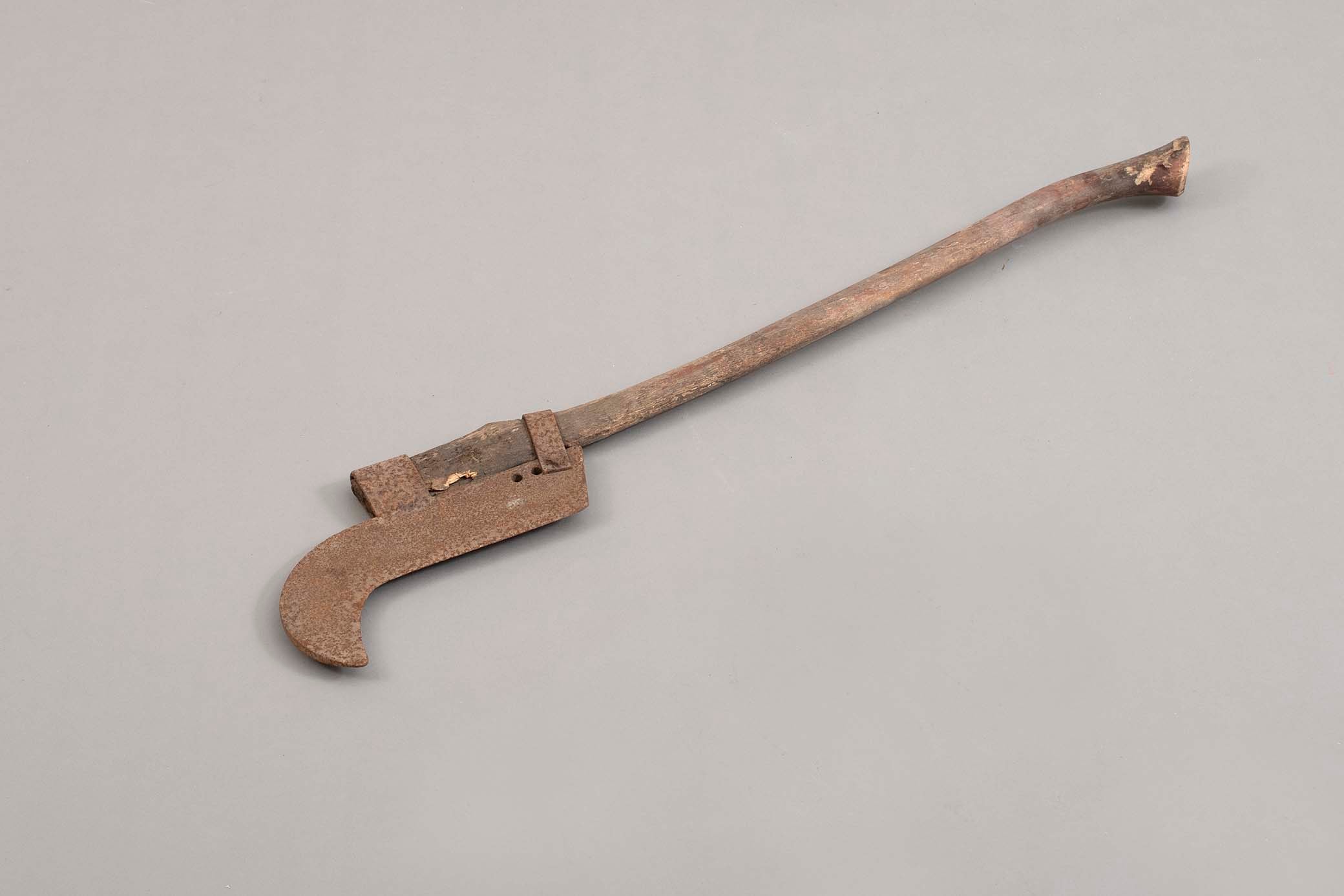
- Description
- Tool with a hooked blade attached to a long wooden handle used for land clearing - cut heavy brush, shrubs, or small trees.
- The blade is made of iron and is heavily rusted. The handle is damaged in several spots and cracked where the blade is attached.
- Object History
- These items belonged to the Hong family - who founded Hop On Farms in Burnaby. Heritage Burnaby has a number of photos and an oral history about the family.
- Classification
- Maintenance T&E - - Groundskeeping Equipment
- Object Term
- Hook, Brush
- Measurements
- Length: 92 cm
- Subjects
- Persons - Chinese Canadians
- Agricultural Tools and Equipment
- Gardens
- Gardens - Market Gardens
- Names
- Hop on Farms
Images

building
https://search.heritageburnaby.ca/link/museumartifact3846
- Repository
- Burnaby Village Museum
- Accession Code
- BV988.33.1
- Description
- The core of the Jessie Love farm house is a 1893 two story, pioneer tent style building. The home was added to over the years and became a large Craftsmen style farm house.
- Object History
- Built on Cumberland Road in Burnaby in 1893. Music Room/Parlour/Living Room and bedrooms above added c.1898. Kitchen added c.1908. The home of Jesse and Martha Love and their eleven children. One of Burnaby's oldest structures. The home was moved to Burnaby Village Museum in the late 1980s and has been partially restored to its 1920s appearance.
- Category
- 01. Built Environment Objects
- Classification
- Structures - - Dwellings
- Object Term
- House
- Colour
- Brown
- Culture
- Canadian
- Geographic Access
- Cumberland Street
- Street Address
- 6501 Deer Lake Avenue
- Historic Neighbourhood
- East Burnaby (Historic Neighbourhood)
- Planning Study Area
- Cariboo-Armstrong Area
Images


Burnaby Lake Neighbourhood
https://search.heritageburnaby.ca/link/landmark755
- Repository
- Burnaby Heritage Planning
- Associated Dates
- 1905-1924
- Heritage Value
- Along with logging and sawmills, Burnaby became known as a prime agricultural area and the Burnaby Lake Neighbourhood saw the development of many vegetable and fruit farms. Growers in the Burnaby and Deer Lake districts took their produce to the tram line on Edmonds Street and shipped it to markets in New Westminster and Vancouver on a specially designed interurban freight car that was open-sided for easy loading. The car's canvas curtains which sometimes came loose and flapped like wings in the wind led people to dub it "the flying dutchman." Most Burnaby fruit and vegetable growers depended on seasonal Chinese work forces and other local Chinese farm residents to oversee operations; these workers being recruited from New Westminsters' Asian community. Besides being good farmers, Burnaby Lake's early residents fostered a strong sense of community. Both L. Claude Hill and his brother Bernard were elected to Burnaby Municipal council and Bernard was the one who knocked on doors to find enough children to meet the qualifications for establishing a school in the district.
- Historic Neighbourhood
- Burnaby Lake (Historic Neighbourhood)
- Planning Study Area
- Morley-Buckingham Area
- Lakeview-Mayfield Area
Images

Cabinet
https://search.heritageburnaby.ca/link/museumartifact90896
- Repository
- Burnaby Village Museum
- Accession Code
- BV021.3.1
- Description
- Worn wooden cabinet made from Douglas Fir and cedar. The interior of the cabinet is painted a pale yellow. One third of the cabinet closest to the ground houses a large open shevling area with the back paneling visible. The middle of the cabinet has 5 slots for drawers with metal handles. One drawer is missing. The top third of the cabinet is split into 2 shelves with a yellow board bisecting the top shelf. Chinese characters are painted in black on the back of the shelving unit.
- Object History
- The cabinet was found in the Thrussell farmhouse on Marine Drive in Burnaby in the 1999.The Thrussell's land had been leased to Chinese tenant farmers by the Thrussell family and also previous owners. The City demolished the house, but they salvaged many items in the house before doing so. Of note are the Chinese characters and the joinery and construction of the cabinet. Chinese characters are painted in black on the back of the shelving unit The first two characters refer to pine wood and the last character is stem or branch.
- Category
- 02. Furnishings
- Classification
- Household Accessories - - Storage & Display Accessories
- Object Term
- Cabinet
- Colour
- Brown
- Yellow
- Measurements
- 42” high x 42” wide x 14” width
- Geographic Access
- Marine Drive
- Nelson Avenue
- Historic Neighbourhood
- Fraser Arm (Historic Neighbourhood)
- Planning Study Area
- Big Bend Area
Images


Coburn House
https://search.heritageburnaby.ca/link/landmark510
- Repository
- Burnaby Heritage Planning
- Description
- The Coburn House is a two and one-half storey plus basement Foursquare farm house. Prominently situated on a rise of land along the east side of Boundary Road overlooking Kingsway, it stands among single-family houses later constructed on its subdivided farm land.
- Associated Dates
- 1910
- Formal Recognition
- Heritage Designation, Community Heritage Register
- Other Names
- Minerva Jane Coburn House
- Street View URL
- Google Maps Street View
- Repository
- Burnaby Heritage Planning
- Other Names
- Minerva Jane Coburn House
- Geographic Access
- Boundary Road
- Associated Dates
- 1910
- Formal Recognition
- Heritage Designation, Community Heritage Register
- Enactment Type
- Bylaw No. 9184
- Enactment Date
- 08/05/1989
- Description
- The Coburn House is a two and one-half storey plus basement Foursquare farm house. Prominently situated on a rise of land along the east side of Boundary Road overlooking Kingsway, it stands among single-family houses later constructed on its subdivided farm land.
- Heritage Value
- The Coburn House is important as a surviving representation of Burnaby’s early settlement period, when the municipality was largely an agricultural and residential suburb. It was built in 1910 by carpenter William Kirkham for Minerva Jane Coburn (1868-1940), and three years later the builder and client were married. Together, they operated the Surprise Poultry Farm, and were frequent participants at the local Central Park Farmers' Institute Exhibitions. This house is valued as an excellent and well-preserved example of a substantial Edwardian era Foursquare farm house. Significant due to its generous size, dominant symmetry, the prominent verandah that wraps around the front and both sides, and the three roof dormers, this house retains a high degree of original material and integrity. The elevated siting of the house, its tall proportions and symmetrical appearance combined with its fine condition make this an excellent example of its type.
- Defining Elements
- Key elements that define the heritage character of the Coburn House include its: - prominent location on Boundary Road, on an elevated site overlooking Vancouver - residential form, scale and massing as expressed by its cubic massing and tall, dominant roof form - Foursquare style as exemplified by its symmetry, square floor plan, pyramidal bellcast roof and three hipped dormers - Edwardian era construction details such as narrow bevelled wooden siding, broad horizontal eave band with scroll-cut eave brackets, and simple window surrounds - wraparound verandah encircling three main facades, with hipped roof, square columns and closed balustrades, connected to one storey extension at rear - projecting bay window on the main floor south facade - original double-hung 1-over-1 wooden-sash windows, some in double assembly on the ground floor - internal red brick chimney
- Historic Neighbourhood
- Central Park (Historic Neighbourhood)
- Planning Study Area
- Garden Village Area
- Function
- Primary Historic--Single Dwelling
- Primary Current--Single Dwelling
- Community
- Burnaby
- Cadastral Identifier
- 002-653-427
- Boundaries
- The Coburn House is comprised of a single residential lot located at 5170 Boundary Road, Burnaby
- Area
- 541.91
- Contributing Resource
- Building
- Ownership
- Private
- Street Address
- 5170 Boundary Road
- Street View URL
- Google Maps Street View
Images


date plaque
https://search.heritageburnaby.ca/link/museumartifact90987
- Repository
- Burnaby Village Museum
- Accession Code
- BV021.11.1
- Description
- Bronze date plaque stamped "F.V.M.P.A./ BURNABY PLANT SOD TURNING / JULY 26, 1962" with 4 corner holes. The object has scratches throughout. The plaque is taped to a cardboard tag with the text "B5102 / $0.80"
- Object History
- The plate is to commemorate the Fraser Valley Milk Producers Assocation Burnaby Plant sod turning ceremony on July 26, 1962, when construction started on the new facility at Sperling and Lougheed. The plant opened in 1964, and housed the FVMPA head offices, fluid milk plant, and ice cream manufacturing division.
- Category
- 08. Communication Artifacts
- Classification
- Documentary Artifacts - - Other Documents
- Object Term
- Plate, Identification
- Measurements
- 6.3cm wide x 3.1cm high
- Subjects
- Foods
- Agriculture
- Agriculture - Dairy
- Historic Neighbourhood
- Lozells (Historic Neighbourhood)
- Planning Study Area
- Government Road Area
Images


Drs. Blythe and Violet Eagles Estate
https://search.heritageburnaby.ca/link/landmark535
- Repository
- Burnaby Heritage Planning
- Description
- The Drs. Blythe and Violet Eagles Estate is a one hectare property located within Deer Lake Park in Burnaby. The property encompasses a carefully conceived garden of local, non-conventional, and exotic plantings. Conceived as a series of rockeries and terraces, the garden cascades from the house do…
- Associated Dates
- 1929
- Formal Recognition
- Heritage Designation, Community Heritage Register
- Other Names
- Eagles Estate Heritage Garden
- Street View URL
- Google Maps Street View
- Repository
- Burnaby Heritage Planning
- Other Names
- Eagles Estate Heritage Garden
- Geographic Access
- Sperling Avenue
- Associated Dates
- 1929
- Formal Recognition
- Heritage Designation, Community Heritage Register
- Enactment Type
- Bylaw No. 11592
- Enactment Date
- 15/09/2003
- Description
- The Drs. Blythe and Violet Eagles Estate is a one hectare property located within Deer Lake Park in Burnaby. The property encompasses a carefully conceived garden of local, non-conventional, and exotic plantings. Conceived as a series of rockeries and terraces, the garden cascades from the house down towards the waterfront, divided by paths and strips of plantings.
- Heritage Value
- The Eagles Estate is significant because of its unique character within Burnaby’s Deer Lake Park heritage precinct, and the people who were its creators and residents. The garden is a unique expression of the talents and tastes of both the Eagles and Frank Ebenezer Buck (1875-1970). Buck served as the Assistant Dominion Horticulturist in charge of landscape horticulture and floriculture in Ottawa from 1912. In 1920, he was head of the Horticultural Department and the Campus Landscape Architect at the University of British Columbia. He established the plan for the Eagles garden while Dr. Blythe Alfred Eagles (1902-1990), the long-time Dean of the Faculty of Agriculture at UBC, selected many of the plantings. The Eagles themselves designed the house as a romantic cottage inspired by the British Arts and Crafts style. Trained in enzyme chemistry, Dr. Violet Evelyn (Dunbar) Eagles (1899-1994) was an enthusiastic amateur gardener, and was perhaps the driving force behind the maintenance and continued development of the garden. The Eagles were also well known in Burnaby for their active volunteerism in the local community as well as at UBC. When Simon Fraser University opened in Burnaby as the Greater Vancouver’s second university, the Eagles, in particular Violet, became well-known for entertaining dignitaries and special guests of the university in their lavish garden. Drs. Blythe and Violet Eagles were recognized for their good citizenship and the ongoing use of their garden for charitable Burnaby-based functions and celebrations.
- Defining Elements
- Due to the extensive and varied nature of the garden, the character-defining elements of the Eagles Estate are many and complex. The elements that encompass the character of the site include its: - British Arts and Crafts-inspired house with original exterior features such as a picturesque roofline, stucco cladding and six- and eight-paned steel-frame casement windows, and original interior features such as the central fireplace, wood floors and kitchen cabinetry - formal staircase leading to the north (formal entry) side of the house - carefully planned yet informal garden design, with 'garden rooms' used to create intimacy - terraced landscape cascading from the house down to the garden - incorporation of local, exotic, flowering and non-flowering plants. - contrast of manicured versus freely growing landscape elements - use of wood lattice fencing gates, arbors and trellis
- Historic Neighbourhood
- Burnaby Lake (Historic Neighbourhood)
- Planning Study Area
- Morley-Buckingham Area
- Community
- Burnaby
- Cadastral Identifier
- P.I.D. No. 007-302-801 Legal Description: Lot 143, District Lot 85, Group 1, New Westminster District, Plan 36335
- Boundaries
- The Eagles Estate is comprised of a single municipally-owned property located at 5655 Sperling Avenue, Burnaby.
- Area
- 6,403.91
- Contributing Resource
- Building
- Landscape Feature
- Documentation
- Heritage Site Files: PC77000 20. City of Burnaby Planning and Building Department, 4949 Canada Way, Burnaby, B.C., V5G 1M2
- Street Address
- 5655 Sperling Avenue
- Street View URL
- Google Maps Street View
Images


Duncan & Margaret McGregor Estate 'Glen-Lyon' Mansion
https://search.heritageburnaby.ca/link/landmark518
- Repository
- Burnaby Heritage Planning
- Description
- Overlooking the rich farmland of the Fraser River floodplain, 'Glen-Lyon' is an Edwardian era rural estate, with a tall, two and one-half storey plus basement wood-frame mansion, set in a pastoral and formal landscape with an associated barn and early log pond, located near a ravine and forested ar…
- Associated Dates
- 1902
- Formal Recognition
- Heritage Designation, Community Heritage Register
- Street View URL
- Google Maps Street View
- Repository
- Burnaby Heritage Planning
- Geographic Access
- Marine Drive
- Associated Dates
- 1902
- Formal Recognition
- Heritage Designation, Community Heritage Register
- Enactment Type
- Bylaw No. 12183
- Enactment Date
- 11/12/2006
- Description
- Overlooking the rich farmland of the Fraser River floodplain, 'Glen-Lyon' is an Edwardian era rural estate, with a tall, two and one-half storey plus basement wood-frame mansion, set in a pastoral and formal landscape with an associated barn and early log pond, located near a ravine and forested area adjacent to Marine Drive in South Burnaby.
- Heritage Value
- ‘Glen-Lyon’ is valued as an excellent example of a privately-owned Edwardian era country estate built at the turn of the nineteenth century. The property retains significant heritage features including the Edwardian era mansion with rustic Arts and Crafts features, and elements of a working agricultural landscape. The property was originally the Royal City Mills logging camp, and in 1900 was purchased by Duncan Campbell McGregor (1853-1929) and Margaret Jane McGregor (1875-1960), who named their estate ‘Glen-Lyon’ after Duncan McGregor’s birthplace in Perthshire, Scotland. The McGregors were active in municipal affairs and social activities, and played a significant role in the early development of Burnaby. Duncan McGregor served as a city councillor from 1909 to 1912 and was elected reeve of Burnaby in 1913. Margaret McGregor was instrumental in the formation and fundraising activities of the Victoria Order of Nurses in Burnaby. Additionally, the site is historically significant for its association with early social welfare and correctional reform. The estate was sold in 1926 to an inter-denominational religious organization called the Home of the Friendless, which used it as their B.C. headquarters. The organization was charged with several cases of abuse and neglect in 1937, after which a Royal Commission was formed that led to new legislation to regulate and license all private welfare institutions. 'Glen-Lyon' was sold to the provincial government, and was dedicated in 1939 by the Lt.-Gov. E.W. Hamber for use as the New Haven Borstal Home for Boys and Youthful Offenders (later renamed the New Haven Correction Centre). The Borstal movement originated in England in the late nineteenth century, as an alternative to sending young offenders and runaways to prisons by providing reformatories that focused on discipline and vocational skill. This site’s role as the first North American institution devoted to the Borstal School philosophy was historic, and influenced corrections programs across Canada. The site retains significant features from its development in 1939 as the Borstal School, including a large gambrel-roofed barn designed by Chief Provincial Architect Henry Whittaker of the Department of Public Works that is the only remaining structure of its kind in Burnaby. Between 1941 and 1945 the mansion housed the Provincial School for the Deaf and Blind when the Borstal School was closed temporarily as a war measure during the Second World War.
- Defining Elements
- Key elements that define the heritage character of 'Glen-Lyon' Mansion include its: - location on a sloping site with expansive southern exposure, adjacent to Marine Drive - residential form, scale and massing of the house as exemplified by its two and one-half storey height, above-ground basement and rectangular plan - Arts and Crafts elements of the house such as its stone foundation, multi-gabled roof line with steep central hipped roof, symmetrical cross-gables, side shed dormers, bellcast upper walls sheathed in cedar shingles and lower walls sheathed in narrow clapboard - original exterior features of the house such as the full width front verandah with square columns, central staircase on the southern elevation, original doors and stained glass windows; and the irregular fenestration such as double-hung 1-over-1 wooden-sash windows, bay windows, and projecting windows in the gable ends - original interior features of the house such as the U-shaped main stair designed around two symmetrically placed Ionic columns, and interior trim on the main floor including boxed beams and fireplaces - gambrel-roofed barn with roof vent with finial, sliding hay loft and access doors, small multi-pane windows, and lapped wooden siding - associated landscape features such as the original garden plantings with some exotic and many native specimen trees; the original log pond and its concrete Marine Drive causeway and culvert; rockeries and a rose garden
- Historic Neighbourhood
- Fraser Arm (Historic Neighbourhood)
- Planning Study Area
- Big Bend Area
- Architect
- Henry Whittaker
- Function
- Primary Historic--Estate
- Community
- Burnaby
- Cadastral Identifier
- 003-004-661
- Boundaries
- 'Glen-Lyon' is comprised of a single residential lot located at 4250 Marine Drive, Burnaby.
- Area
- 230873.18
- Contributing Resource
- Building
- Ownership
- Private
- Names
- McGregor, Duncan C. (1853-1929)
- Whittaker, Henry
- Home of the Friendless
- Borstal School
- New Haven Correction Centre
- Subjects
- Buildings - Heritage
- Buildings - Residential - Houses
- Buildings - Public - Detention Facilities
- Buildings - Residential
- Street Address
- 4250 Marine Drive
- Street View URL
- Google Maps Street View
Images


Duncan & Margaret McGregor Estate 'Glen-Lyon' New Haven Barn
https://search.heritageburnaby.ca/link/landmark852
- Repository
- Burnaby Heritage Planning
- Description
- Designed in a vernacular architectural style, the New Haven Barn is a large gambrel-roofed barn located on the Edwardian era McGregor Estate 'Glen-Lyon,' overlooking the rich farmland of the Fraser River floodplain and near a ravine and forested area adjacent to Marine Drive in South Burnaby.
- Associated Dates
- 1939
- Formal Recognition
- Heritage Designation, Community Heritage Register
- Other Names
- Home of the Friendless, New Haven Borstal Home for Boys and Youthful Offenders, New Haven Correction Centre
- Street View URL
- Google Maps Street View
- Repository
- Burnaby Heritage Planning
- Other Names
- Home of the Friendless, New Haven Borstal Home for Boys and Youthful Offenders, New Haven Correction Centre
- Geographic Access
- Marine Drive
- Associated Dates
- 1939
- Formal Recognition
- Heritage Designation, Community Heritage Register
- Enactment Type
- Bylaw No. 12183
- Enactment Date
- 11/12/2006
- Description
- Designed in a vernacular architectural style, the New Haven Barn is a large gambrel-roofed barn located on the Edwardian era McGregor Estate 'Glen-Lyon,' overlooking the rich farmland of the Fraser River floodplain and near a ravine and forested area adjacent to Marine Drive in South Burnaby.
- Heritage Value
- The site is historically significant for its association with early social welfare and correctional reform. The estate was sold in 1926 to an inter-denominational religious organization called the Home of the Friendless, which used it as their B.C. headquarters. The organization was charged with several cases of abuse and neglect in 1937, after which a Royal Commission was formed that led to new legislation to regulate and license all private welfare institutions. 'Glen-Lyon' was sold to the provincial government, and was dedicated in 1939 by the Lt.-Gov. E.W. Hamber for use as the New Haven Borstal Home for Boys and Youthful Offenders (later renamed the New Haven Correction Centre). The Borstal movement originated in England in the late nineteenth century, as an alternative to sending young offenders and runaways to prisons by providing reformatories that focused on discipline and vocational skill. This site’s role as the first North American institution devoted to the Borstal School philosophy was historic, and influenced corrections programs across Canada. The New Haven Barn is a significant feature from its development in 1939 as the Borstal School, designed by Chief Provincial Architect Henry Whittaker of the Department of Public Works, and is the only remaining structure of its kind in Burnaby.
- Defining Elements
- Key elements that define the heritage character of the New Haven Barn include its: - gambrel-roofed barn with roof vent with finial, sliding hay loft and access doors, small multi-pane windows, and lapped wooden siding
- Historic Neighbourhood
- Fraser Arm (Historic Neighbourhood)
- Planning Study Area
- Big Bend Area
- Architect
- Henry Whittaker
- Function
- Primary Historic--Estate
- Community
- Burnaby
- Cadastral Identifier
- 003-004-661
- Boundaries
- 'Glen-Lyon' is comprised of a single residential lot located at 4250 Marine Drive, Burnaby.
- Area
- 230873.18
- Contributing Resource
- Building
- Ownership
- Private
- Names
- Whittaker, George
- New Haven Borstal Home for Boys and Youthful Offenders
- New Haven Correction Centre
- Borstal School
- Street Address
- 4250 Marine Drive
- Street View URL
- Google Maps Street View
Images


Fraser Arm Neighbourhood
https://search.heritageburnaby.ca/link/landmark708
- Repository
- Burnaby Heritage Planning
- Associated Dates
- 1925-1954
- Heritage Value
- By the late 1920s, the Fraser Arm Neighbourhood in Burnaby was developing into an industrial and manufacturing district. In 1931, the Canadian National Railway built a bridge over the Fraser River from Burnaby to Lulu Island and advertised that over 30 industries were currently operating along the North Fraser. Along with industries, this district remained an important agricultural area for the Lower Mainland. Chinese market gardens continued to develop and thrive and in 1926, the Vancouver Sun estimated that that Chinese farms in the Lower Fraser Valley then supplied 90 per cent of all green vegetables consumed in the Vancouver market area.
- Historic Neighbourhood
- Fraser Arm (Historic Neighbourhood)
- Planning Study Area
- Big Bend Area
Images


Fraser Arm Neighbourhood
https://search.heritageburnaby.ca/link/landmark737
- Repository
- Burnaby Heritage Planning
- Repository
- Burnaby Heritage Planning
- Heritage Value
- Hugh MacRoberts, a farmer on Sea Island in Richmond, constructed a trail (which later became Marine Drive) to New Westminster in 1862 in order to bring his produce to market. The land along the Fraser River had been used as cranberry bogs and the fertile soil allowed opportunities for hay, root crops and other agricultural endeavours. The settlement grew around the River Road and by 1905 the Dundonald School opened, followed three years later by the Fraser Arm Post Office.
- Historic Neighbourhood
- Fraser Arm (Historic Neighbourhood)
- Planning Study Area
- Big Bend Area
Images


Fraser Arm Neighbourhood
https://search.heritageburnaby.ca/link/landmark767
- Repository
- Burnaby Heritage Planning
- Associated Dates
- 1905-1924
- Heritage Value
- Fraser Arm - so named because there the tram crossed Gilley Avenue, running down to the North Arm of the Fraser River - was served by the River Road [Marine Drive] which traversed the municipality of Burnaby, leading to both New Westminster and Vancouver. This area did not experience a real estate boom during the 1909-1913 as did many other Burnaby neighbourhoods - in fact, by 1912, only three homes had been built along Riverway as it remained a predominantly agricultural area.
- Historic Neighbourhood
- Fraser Arm (Historic Neighbourhood)
- Planning Study Area
- Big Bend Area
Images


H.T. Ceperley Estate 'Fairacres' Chauffeur's Cottage
https://search.heritageburnaby.ca/link/landmark529
- Repository
- Burnaby Heritage Planning
- Description
- Designed in the British Arts and Crafts style, the Chauffeur's Cottage is situated across from the main entrance to the Ceperley Mansion, and adjacent to the Garage and Stables. A long, narrow single-storey building, it was constructed by joining together two modest estate cottages.
- Associated Dates
- 1911
- Formal Recognition
- Heritage Designation, Community Heritage Register
- Repository
- Burnaby Heritage Planning
- Geographic Access
- Deer Lake Avenue
- Associated Dates
- 1911
- Formal Recognition
- Heritage Designation, Community Heritage Register
- Enactment Type
- Bylaw No. 9807
- Enactment Date
- 23/11/1992
- Description
- Designed in the British Arts and Crafts style, the Chauffeur's Cottage is situated across from the main entrance to the Ceperley Mansion, and adjacent to the Garage and Stables. A long, narrow single-storey building, it was constructed by joining together two modest estate cottages.
- Heritage Value
- The outbuildings at 'Fairacres' are a rare surviving architecturally designed ensemble of agricultural structures that exist in complementary harmony with the main estate house. Architect Robert Mackay Fripp (1858-1917) was retained by the Ceperleys to design several original outbuildings on their estate at the same time as the main house was constructed. The Chauffeur's Cottage illustrates the increasing importance of the automobile in the lives of the wealthy of the early twentieth century. It also demonstrates Grace and Henry Tracy Ceperley's social aspirations and grand-country-estate pretension in having a chauffeur. The cottage's location - close to the garage and convenient, but not adjacent, to the main house - enhances the grand country house landscape design and contributes to the overall composition of the estate's plan. The Arts and Crafts styled Chauffeur's Cottage is important as an indicator of the aesthetic and social sensibilities of the Ceperley family in retaining an architect to design a modest building for staff accommodation.
- Defining Elements
- Key elements that define the heritage character of the 'Fairacres' Chauffeur's Cottage include its: - location, in relation to the main house and in close proximity to the Garage and Stables buildings - side gable roof with cedar shingle cladding - Arts and Crafts architectural features such as the jerkin-headed door hood, a reference to the thatched-roofed cottages of southern England; eight-paned wooden-sash casement windows; and cedar-shingled exterior - two internal brick chimneys - modest, functional interior, with simple trim and lack of pretension
- Locality
- Deer Lake Park
- Historic Neighbourhood
- Burnaby Lake (Historic Neighbourhood)
- Planning Study Area
- Douglas-Gilpin Area
- Architect
- Robert Mackay Fripp
- Function
- Primary Historic--Outbuilding
- Community
- Burnaby
- Cadastral Identifier
- P.I.D. No. 004-493-311 Legal Description: Block 3 Except: Part subdivided by Plan 26865, District Lot 79, Group 1, New Westminster District, Plan 536
- Boundaries
- ‘Fairacres’ is comprised of a single municipally-owned property located at 6344 Deer Lake Avenue, Burnaby.
- Area
- 17,065.00
- Contributing Resource
- Building
- Landscape Feature
- Ownership
- Public (local)
- Other Collection
- Burnaby Historical Society, Community Archives: Ceperley Photograph Album Burnaby Village Museum, Collection: Chinese ‘Tiger Whiskey’ and opium bottles found during restoration
- Documentation
- Heritage Site Files: PC77000 20. City of Burnaby Planning and Building Department, 4949 Canada Way, Burnaby, B.C., V5G 1M2
- Street Address
- 6344 Deer Lake Avenue
Images


H.T. Ceperley Estate 'Fairacres' Estate Gate
https://search.heritageburnaby.ca/link/landmark863
- Repository
- Burnaby Heritage Planning
- Description
- The 'Fairacres Estate Gate' marks the location of one of the original driveway entrances to the estate.
- Associated Dates
- 1911
- Formal Recognition
- Heritage Designation, Community Heritage Register
- Street View URL
- Google Maps Street View
- Repository
- Burnaby Heritage Planning
- Geographic Access
- Deer Lake Avenue
- Associated Dates
- 1911
- Formal Recognition
- Heritage Designation, Community Heritage Register
- Enactment Type
- Bylaw No. 140665
- Enactment Date
- 23/11/1992
- Description
- The 'Fairacres Estate Gate' marks the location of one of the original driveway entrances to the estate.
- Heritage Value
- Fairacres was designed as a country estate with a working farm that included over 10 acres of productive berry and vegetable fields, with a large kitchen garden, a root house to store food, and greenhouses heated by steam. The agricultural potential ofthe Deer Lake area made it one of the first parts of the municipality to attract settlement. Construction of the Fairacres Estate represented a shift toward wealthy country estates over more modest farms, and the Ceperleys employed a large staff to manage the estate's agricultural production. Agricultural use of the estate continued when a Catholic order of Benedictine monks purchased the estate as part of the Priory of St. Joseph and the Seminary of Christ the King, and continued to farm the land until 1953. The overall architectural intention of the estate's architect was to reflect the ideals of the Arts & Crafts movement to showcase craftsmanship, and to incorporate high quality materials, including many local materials, such as wood and stone from the site. On the mansion exterior, the rustic style is seen in the use of natural materials such as cedar shingles and siding, cobblestone foundations and chimneys and the half-timbering in gable ends. The estate's remaining gate pillar features the same rustic field and cobblestones used on the mansion. The original estate driveway had two entrances constructed in 1910, each marked by a pair of entry gate pillars which supported iron gates. The main entrance gate pillars which marked the lower driveway and the east pillar of the upper entrance were demolished many years ago and the iron gates removed. A single gate pillar remains marking the upper driveway, adjacent to the Garage and Stables. This gate pillar is a significant site feature and incorporates cobble stone and a carved sandstone capstone.
- Defining Elements
- Key elements that define the heritage character of the ‘Fairacres Estate Gate' include: - setting in relation to the estate boundary and estate buildings - Cobble stone and sandstone construction, which represents a typical Arts and Crafts use of local materials, and matches the extensive use of cobblestone as chimneys and foundations on the Fairacres mansion, as well as the use of sandstone on the mansion's exterior.
- Locality
- Deer Lake Park
- Historic Neighbourhood
- Burnaby Lake (Historic Neighbourhood)
- Planning Study Area
- Douglas-Gilpin Area
- Function
- Primary Historic--Estate
- Community
- Burnaby
- Cadastral Identifier
- P.I.D. No. 004-493-311 Legal Description: Block 3 Except: Part subdivided by Plan 26865, District Lot 79, Group 1, New Westminster District, Plan 536
- Boundaries
- ‘Fairacres’ is comprised of a single municipally-owned property located at 6344 Deer Lake Avenue, Burnaby.
- Area
- 17,065.00
- Contributing Resource
- Landscape Feature
- Ownership
- Public (local)
- Other Collection
- Burnaby Historical Society, Community Archives: Ceperley Photograph Album
- Documentation
- Heritage Site Files: PC77000 20. City of Burnaby Planning and Building Department, 4949 Canada Way, Burnaby, B.C., V5G 1M2
- Subjects
- Structures - Fences
- Street Address
- 6344 Deer Lake Avenue
- Street View URL
- Google Maps Street View
Images


H.T. Ceperley Estate 'Fairacres' Garage & Stables
https://search.heritageburnaby.ca/link/landmark530
- Repository
- Burnaby Heritage Planning
- Description
- Designed in the British Arts and Crafts style, the ‘Fairacres’ Garage and Stables is a two-storey wood frame building located on the 'Fairacres' estate, situated to the north of the Chauffeur's Cottage; at the south end of the structure is a single vehicle garage and to the north are several stable…
- Associated Dates
- 1911
- Formal Recognition
- Heritage Designation, Community Heritage Register
- Street View URL
- Google Maps Street View
- Repository
- Burnaby Heritage Planning
- Geographic Access
- Deer Lake Avenue
- Associated Dates
- 1911
- Formal Recognition
- Heritage Designation, Community Heritage Register
- Enactment Type
- Bylaw No. 9807
- Enactment Date
- 23/11/1992
- Description
- Designed in the British Arts and Crafts style, the ‘Fairacres’ Garage and Stables is a two-storey wood frame building located on the 'Fairacres' estate, situated to the north of the Chauffeur's Cottage; at the south end of the structure is a single vehicle garage and to the north are several stables for carriage, riding, and draught horses, a coach house, and tack room; the upper floor was originally a hay loft.
- Heritage Value
- The outbuildings at 'Fairacres' are a rare surviving architecturally designed ensemble of agricultural structures that exist in complementary harmony with the main estate house. Architect Robert Mackay Fripp (1858-1917) was retained by the Ceperleys to design several original outbuildings on their estate at the same time as the main house was constructed. The Garage and Stables building is important as a record of its era when transportation modes were in transition and the horse-drawn carriage, while still in use, was giving way to the automobile. The relative spatial arrangements within the building are a valuable indication of the economy of space associated with the automobile, as compared to the horse. The extent of the stabling arrangements signifies not only the use of carriage horses but also the continued reliance on draught horses in farming activities in this era. As well, it is an indication of the fashionable nature of equestrianism for wealthy families during this time. The building is important as a demonstration of the aesthetics of the Ceperley family in having an architect-designed outbuilding and obtaining craftsmanship and materials of the highest quality for each structure on their estate.
- Defining Elements
- Key elements that define the heritage character of the 'Fairacres' Garage and Stables include its: - location within easy reach of the main house and in close proximity to the Chauffeur's Cottage - floor plan with the garage at one end, close to the Chauffeur's Cottage, and stables and equine facilities at the other - variety and complexity of the roofline, including gable wall dormers, gable-on-hip roof ends, and half-hip extensions - Arts and Crafts architectural features of the exterior such as the shingle wall cladding articulated with a chevron-patterned course of shingles at the first floor level; casement windows; and deep eaves with additional purlins to support the overhang - original stable doors with hand-made forged-iron door hardware - multi-paned wooden-sash windows, some retaining original wire glass
- Locality
- Deer Lake Park
- Historic Neighbourhood
- Burnaby Lake (Historic Neighbourhood)
- Planning Study Area
- Douglas-Gilpin Area
- Architect
- Robert Mackay Fripp
- Function
- Primary Historic--Outbuilding
- Community
- Burnaby
- Cadastral Identifier
- P.I.D. No. 004-493-311 Legal Description: Block 3 Except: Part subdivided by Plan 26865, District Lot 79, Group 1, New Westminster District, Plan 536
- Boundaries
- ‘Fairacres’ is comprised of a single municipally-owned property located at 6344 Deer Lake Avenue, Burnaby.
- Area
- 17,065.00
- Contributing Resource
- Building
- Landscape Feature
- Ownership
- Public (local)
- Other Collection
- Burnaby Historical Society, Community Archives: Ceperley Photograph Album
- Documentation
- Heritage Site Files: PC77000 20. City of Burnaby Planning and Building Department, 4949 Canada Way, Burnaby, B.C., V5G 1M2
- Street Address
- 6344 Deer Lake Avenue
- Street View URL
- Google Maps Street View
Images


H.T. Ceperley Estate 'Fairacres' Greenhouse Foundation Wall
https://search.heritageburnaby.ca/link/landmark862
- Repository
- Burnaby Heritage Planning
- Description
- The original rubble stone walls that formed the foundation for a greenhouses adjacent to the Steam Plant Building provided heat to several greenhouses on the estate propoerty. The Root House, which is to the north of the Greenhouse Foundation Wall, provided storage for the farm operation.
- Associated Dates
- 1908
- Formal Recognition
- Heritage Designation, Community Heritage Register
- Repository
- Burnaby Heritage Planning
- Geographic Access
- Deer Lake Avenue
- Associated Dates
- 1908
- Formal Recognition
- Heritage Designation, Community Heritage Register
- Enactment Type
- Bylaw No. 140665
- Enactment Date
- 23/11/1992
- Description
- The original rubble stone walls that formed the foundation for a greenhouses adjacent to the Steam Plant Building provided heat to several greenhouses on the estate propoerty. The Root House, which is to the north of the Greenhouse Foundation Wall, provided storage for the farm operation.
- Heritage Value
- The outbuildings at 'Fairacres' are a rare surviving architecturally-designed ensemble of agricultural structures that exist in complementary harmony with the main estate house. Architect Robert Mackay Fripp (1858-1917), an outspoken advocate of Arts and Crafts design, was retained by the Ceperleys to design several original outbuildings on their estate, which was designed as a country estate with a working farm that included over 10 acres of productive berry and vegetable fields, with a large kitchen garden, a root house to store food, an orchard, and greenhouses heated by steam. The agricultural potential of the Deer Lake area made it one of the first parts of the municipality to attract settlement. In 1909, the Ceperleys built three large greenhouses heated by an adjacent steam plant (Fairacres Steam Plant). The greenhouses featured granite foundation walls, including this one which remains intact. The Ceperleys employed a large staff to manage the estate's agricultural production, including Chinese farm labourers. Produce was grown for use at the estate, and for sale at local markets. Agricultural use of the estate continued when a Catholic order of Benedictine monks purchased the estate as part of the Priory of St. Joseph and the Seminary of Christ the King, and continued to farm the land until 1953.
- Defining Elements
- Key elements that define the heritage character of the ‘Fairacres’ Steam Plant Building include its: - overall spatial arrangement of the Greenhouse Foundation Wall in relation to the Steam Plant Building and the Root House - original rubble stone walls reflecting the Arts and Crafts design aesthetic of the estate buildings.
- Locality
- Deer Lake Park
- Historic Neighbourhood
- Burnaby Lake (Historic Neighbourhood)
- Planning Study Area
- Douglas-Gilpin Area
- Architect
- Robert Mackay Fripp
- Function
- Primary Historic--Outbuilding
- Community
- Burnaby
- Cadastral Identifier
- P.I.D. No. 004-493-311 Legal Description: Block 3 Except: Part subdivided by Plan 26865, District Lot 79, Group 1, New Westminster District, Plan 536
- Boundaries
- ‘Fairacres’ is comprised of a single municipally-owned property located at 6344 Deer Lake Avenue, Burnaby.
- Area
- 17,065.00
- Contributing Resource
- Landscape Feature
- Remains
- Ownership
- Public (local)
- Other Collection
- Burnaby Historical Society, Community Archives: Ceperley Photograph Album
- Documentation
- Heritage Site Files: PC77000 20. City of Burnaby Planning and Building Department, 4949 Canada Way, Burnaby, B.C., V5G 1M2
- Street Address
- 6344 Deer Lake Avenue
Images

