Narrow Results By
Decade
- 2020s 96
- 2010s 234
- 2000s 348
- 1990s 541
- 1980s 509
- 1970s 601
- 1960s 691
- 1950s 860
- 1940s 1136
- 1930s 1444
- 1920s 1501
- 1910s 1116
- 1900s 469
- 1890s 197
- 1880s 175
- 1870s 75
- 1860s 132
- 1850s 21
- 1840s 6
- 1830s 2
- 1820s 2
- 1810s 4
- 1800s 3
- 1790s 3
- 1780s 3
- 1770s 3
- 1760s 3
- 1750s 3
- 1740s 3
- 1730s 3
- 1720s 3
- 1710s 3
- 1700s 3
- 1690s 3
- 1680s 3
- 1670s 2
- 1660s 2
- 1650s 2
- 1640s 2
- 1630s 2
- 1620s 2
- 1610s 2
- 1600s 2
- 1590s 1
- 1580s 1
- 1570s 1
- 1560s 1
- 1550s 1
- 1540s 1
- 1530s 1
- 1520s 1
- 1510s 1
- 1500s 1
- 1490s 1
- 1480s 1
Subject
- Accidents 4
- Accidents - Automobile Accidents 2
- Accidents - Train Accidents 17
- Advertising Medium 6
- Advertising Medium - Flyer 3
- Advertising Medium - Signs and Signboards 14
- Aerial Photographs 9
- Agricultural Tools and Equipment 16
- Agricultural Tools and Equipment - Cultivators 3
- Agricultural Tools and Equipment - Gardening Equipment 8
- Agricultural Tools and Equipment - Plows 1
- Agricultural Tools and Equipment - Tractors 1
Creator
- Adair, Neal G. 3
- Adams, Gladstone 1
- Alberta. Alberta Culture 1
- Alcott, Louisa May, 1832-1888 3
- Anderson, I. 1
- Anderson, Robert "Bob" 1
- Andrews, W. & Son 1
- Anthony's of Kerrisdale 1
- Armstrong, Sophie 1
- Ashmore, Sidney G. (Sidney Gillespie), 1852-1911 1
- Atkinson, Dorothy Mallett 1
- Aujla, Kehar Singh 1
Amendments to Solid Waste and Recycling Bylaw 2010 for Single-Family, Two-Family, and Row House Properties
https://search.heritageburnaby.ca/link/councilreport83360
- Repository
- Legislative Services
- Report ID
- 93899
- Meeting Date
- 08-Nov-2021
- Format
- Council - Manager's Report
- Item No.
- 1
- Collection/Fonds
- City Council and Office of the City Clerk fonds
- Repository
- Legislative Services
- Report ID
- 93899
- Meeting Date
- 08-Nov-2021
- Format
- Council - Manager's Report
- Item No.
- 1
- Collection/Fonds
- City Council and Office of the City Clerk fonds
Documents
Covenant for the Control of Occupancy - Single Family and Two Family Dwellings
https://search.heritageburnaby.ca/link/councilreport25277
- Repository
- City of Burnaby Archives
- Report ID
- 18562
- Meeting Date
- 21-Jul-1975
- Format
- Council - Manager's Report
- Manager's Report No.
- 49
- Item No.
- 9
- Collection/Fonds
- City Council and Office of the City Clerk fonds
- Repository
- City of Burnaby Archives
- Report ID
- 18562
- Meeting Date
- 21-Jul-1975
- Format
- Council - Manager's Report
- Manager's Report No.
- 49
- Item No.
- 9
- Collection/Fonds
- City Council and Office of the City Clerk fonds
Documents
Digney family at Bonsor Avenue and family outings
https://search.heritageburnaby.ca/link/archivedescription85309
- Repository
- City of Burnaby Archives
- Date
- [between 1946 and 1947]
- Collection/Fonds
- Digney Family fonds
- Description Level
- Item
- Physical Description
- 1 film clip (13 min., 10 sec.) : digital,col., si.
- Scope and Content
- Item is a digitized silent colour film segment identified as Reel 15. Film footage opens with Andy and Alice Digney in the yard of the Digney family home on Bonsor Avenue and their son Ernest Frank (Dig) and his wife Dorothy (Dot) with thier infant son Paul at age 6 months and later as a toddler wi…
- Repository
- City of Burnaby Archives
- Date
- [between 1946 and 1947]
- Collection/Fonds
- Digney Family fonds
- Physical Description
- 1 film clip (13 min., 10 sec.) : digital,col., si.
- Description Level
- Item
- Record No.
- 562-003-15
- Access Restriction
- No restrictions
- Reproduction Restriction
- May be restricted by third party rights
- Accession Number
- 2014-04
- Scope and Content
- Item is a digitized silent colour film segment identified as Reel 15. Film footage opens with Andy and Alice Digney in the yard of the Digney family home on Bonsor Avenue and their son Ernest Frank (Dig) and his wife Dorothy (Dot) with thier infant son Paul at age 6 months and later as a toddler with a variety of family members. Footage also includes a view of Prince George, family members with Elephants and ponies from the Bible Brothers Circus, the Crystal Pool and Butchart Gardens in Victoria. The film closes with Paul, grandpa Dig and the family dog, Nero back in the yard of their home on Bonsor Avenue.
- Media Type
- Moving Images
- Photographer
- Digney, Andy
- Creator
- Digney, Andy
- Notes
- Title based on contents of film
- Geographic Access
- Bonsor Avenue
- Historic Neighbourhood
- Central Park (Historic Neighbourhood)
- Planning Study Area
- Maywood Area
Images
Video
Digney family at Bonsor Avenue and family outings, [between 1946 and 1947]
Digney family at Bonsor Avenue and family outings, [between 1946 and 1947]
https://search.heritageburnaby.ca/media/hpo/_Data/_Archives_Moving_Images/_Unrestricted/562-003-15.m4vHill family and Vidal family fonds
https://search.heritageburnaby.ca/link/archivedescription82116
- Repository
- City of Burnaby Archives
- Date
- [1850-1983]
- Collection/Fonds
- Hill family and Vidal family fonds
- Description Level
- Fonds
- Physical Description
- 255 photographs : b&w and sepia and 9.5 cm of textual records : ill. (some col.)
- Scope and Content
- Fonds consists of photographs and textual records from the Vidal and Hill family. Textual records include handwritten family trees, typed and handwritten biographical information of the Jones, Wright, Hyde, Vidal, and Hill families, copies of photographic prints, published works by J. H. Vidal and …
- Repository
- City of Burnaby Archives
- Date
- [1850-1983]
- Collection/Fonds
- Hill family and Vidal family fonds
- Physical Description
- 255 photographs : b&w and sepia and 9.5 cm of textual records : ill. (some col.)
- Description Level
- Fonds
- Access Restriction
- No restrictions
- Accession Number
- 2013-03
- Scope and Content
- Fonds consists of photographs and textual records from the Vidal and Hill family. Textual records include handwritten family trees, typed and handwritten biographical information of the Jones, Wright, Hyde, Vidal, and Hill families, copies of photographic prints, published works by J. H. Vidal and William Cowper, newspaper clippings, and a New Testament.
- History
- Minard Gerald “Gerry” Hill was born in Burnaby on July 31, 1893, to Marian (nee Berkeley) and Bernard Richard Hill. Marian was born in London, England. Bernard Hill, born in Bengal, India, in 1858 to Sir Richard Hill and Jane Ann (nee Rollinson) where his father worked for the East Indian Railway, was one of the early inhabitants of Burnaby. Despite their years of training as engineers, Bernard, along with his brother, Louis Claude Hill, became strawberry farmers and owned all the land between Burnaby Lake and Deer Lake where Deer Creek runs, and halfway around Deer Lake. Bernard built his family home at Douglas Road near Deer Lake in 1892. After the decline in the strawberry industry, Bernard worked as a surveyor for the municipality. Bernard also served as a Burnaby trustee and as councilor of Burnaby in 1904, 1905, 1906, and 1909. Bernard and Marian had four children: A. Claude (born in England around 1885, married Marion “Mamie”), Frank L., Winnifred “Winnie” L., and Gerry. Gerry attended Miss Harriet Woodward’s kindergarten class, and went on to Edmonds School with Miss Ellen Lister as his teacher. He later went to Central High School in New Westminster, often on horseback. Gerry served in World War I, signing his recruitment papers on November 9, 1914. When he returned home, he worked felling trees, then as an apprentice surveyor and finally as a carpenter. His father, Bernard, died in Burnaby on March 27, 1939, at the age of 80. Bernard's brother, Louis, was one of the first members elected to the Burnaby council and served in 1892, 1893, 1894, and again from 1909-1910. Louis, born in 1860, married Annie Sarah Kendrick (born in 1896) and they moved to the Burnaby Lake area in the early 1890s. Together they had one child, Katherine “Kitty” Maude, born in 1898. The first Hill family home, “Brookfield,” was sold around 1907 and the family moved to their new home, “Broadview,” which was also built in the vicinity of Deer Lake. Kitty, their only child, married William “Bob” John Peers in 1925 and they went on to have three children: Robert C.K., Barbara (later Barbara Jeffrey), and Anne (later Anne Latham). Charlotte Elizabeth Vidal was born in 1897 in the United States to Louisa Sophia (nee Jones) and Herbert P. Vidal. Louisa Vidal (1871-1943) was a descendent of Jones of Exeter of England and the House of Llanio Cardigan of Wales. Herbert Vidal (1868-1934)’s father was Alexander Vidal (1819-1906). Alexander Vidal, born in Brocknell, England, immigrated to Upper Canada in 1835 and later served as a senator of Canada from 1873 to 1906. He married Catherine Louisa Wright, the daughter of Capt. William Elliot Wright. Both of Charlotte’s parents, Louisa and Herbert, were born in Ontario. Charlotte Vidal was sister to Dorothy Kate and Alexander E. E. Vidal. Gerry Hill (aged 27) and Charlotte E. Vidal (aged 23) married on September 28, 1920, in Vancouver. Gerry built a house for him and his wife about a thousand feet from his parents’ home. He also bought property at Yellow Point on Vancouver Island around this time. By the early 1930s, Gerry had moved to Yellow Point permanently and begun building the Yellow Point Lodge. Gerry and Charlotte bore three children: David, Lesley C. (born in 1929), and Gerald. Gerry was later remarried to Elizabeth (nee Holen) and had one child: Richard Grant McEwan Hill, born in Ladysmith. Lesley married M. Clarke and had two boys: Roy and Graham. She later married B. Durban and had four boys: Patrick, Michael, Gary, and Grant. Charlotte died on February 11, 1984, at the age of 87. Gerry died on January 30, 1988, in Ladysmith at the age of 93.
- Media Type
- Photograph
- Textual Record
- Creator
- Hill Family
- Vidal family
- Notes
- Title based on contents of fonds
- Photo catalogue 550, MSS176
Hill family and Vidal family papers series
https://search.heritageburnaby.ca/link/archivedescription82702
- Repository
- City of Burnaby Archives
- Date
- [1850-1983]
- Collection/Fonds
- Hill family and Vidal family fonds
- Description Level
- Series
- Physical Description
- 9.5 cm of textual records
- Scope and Content
- Series consists of five files: (1). Jones family textual records; (2). Wright family textual records; (3). Hyde family textual records; (4) Vidal family textual records; and (5). Hill family textual records.
- Repository
- City of Burnaby Archives
- Date
- [1850-1983]
- Collection/Fonds
- Hill family and Vidal family fonds
- Physical Description
- 9.5 cm of textual records
- Description Level
- Series
- Access Restriction
- No restrictions
- Reproduction Restriction
- May be restricted by third party rights
- Accession Number
- 2013-03
- Scope and Content
- Series consists of five files: (1). Jones family textual records; (2). Wright family textual records; (3). Hyde family textual records; (4) Vidal family textual records; and (5). Hill family textual records.
- Media Type
- Textual Record
- Notes
- Title based on contents of series
Hill family and Vidal family photographs
https://search.heritageburnaby.ca/link/archivedescription82117
- Repository
- City of Burnaby Archives
- Date
- [1860-1940]
- Collection/Fonds
- Hill family and Vidal family fonds
- Description Level
- Series
- Physical Description
- 255 photographs
- Scope and Content
- Series consists of a photographic album holding two hundred fifty-three photographs and twenty-seven slides compiled by the Hill family and the Vidal family.
- Repository
- City of Burnaby Archives
- Date
- [1860-1940]
- Collection/Fonds
- Hill family and Vidal family fonds
- Physical Description
- 255 photographs
- Description Level
- Series
- Record No.
- 550
- Access Restriction
- No restrictions
- Reproduction Restriction
- May be restricted by third party rights
- Accession Number
- 2013-03
- Scope and Content
- Series consists of a photographic album holding two hundred fifty-three photographs and twenty-seven slides compiled by the Hill family and the Vidal family.
- Media Type
- Photograph
- Notes
- Title based on contents of series
Peers Family and Hill Family fonds
https://search.heritageburnaby.ca/link/archivedescription98
- Repository
- City of Burnaby Archives
- Date
- [1880-1980]
- Collection/Fonds
- Peers Family and Hill Family fonds
- Description Level
- Fonds
- Physical Description
- ca. 1200 photographs and other material
- Scope and Content
- Fonds consists of records, primarily photographs, compiled by various members of both the Hill and Peers families that document their lives during the early days of settlement in Burnaby. The fonds includes records of citizenship, wills and other official papers pertaining to the life and activitie…
- Repository
- City of Burnaby Archives
- Date
- [1880-1980]
- Collection/Fonds
- Peers Family and Hill Family fonds
- Physical Description
- ca. 1200 photographs and other material
- Description Level
- Fonds
- Access Restriction
- No restrictions
- Accession Number
- 2007-12
- Scope and Content
- Fonds consists of records, primarily photographs, compiled by various members of both the Hill and Peers families that document their lives during the early days of settlement in Burnaby. The fonds includes records of citizenship, wills and other official papers pertaining to the life and activities of L. Claude Hill; photographs of the Peers family’s Burnaby Lake home, Greyfriars, and pictures taken by Arthur Peers during his work and travels throughout British Columbia in the first part of the 20th century; and photographs of the family of Claude Hill, early Burnaby Lake residents and scenes, and pictures Kitty took as an adult documenting the growth of her own family. Also included in this fonds are a number of photographs showing Yellow Point, Vancouver Island, where the Peers and Hill families often vacationed.
- History
- Bob Peers was born William John Peers, the son of real estate broker and early Burnaby resident, Francis John Peers and his wife Elizabeth Frisby. Originally from England, the family moved to Vancouver in 1905 and soon after settled at Burnaby Lake. The family included one daughter (Mary Elizabeth Dora) and four boys (Arthur Francis, William John “Bob”, Geoffrey Hugh, and Richard Dominic). When they arrived in Burnaby, Francis Peers purchased a piece of land from another early settler, Claude Hill, and built the family home “Greyfriars” near Deer Lake. The children attended school in the home of Miss Harriet Woodward, the first school to be held in the Burnaby Lake area. In 1925, Bob married Claude Hill’s daughter and another former pupil of “Miss Harry’s,” Kitty Hill. Kitty (born Katherine Maude Hill) was the only child of Burnaby pioneers L. Claude Hill and Annie Sara Kenrick. Having moved to the Burnaby Lake area in the early 1890s, Claude went on to operate a successful strawberry farm and soon became active in the political development of Burnaby – being elected to the first Burnaby Council and serving from 1892-1894 and again from 1909-1910. The first Hill family home, “Brookfield,” was sold around 1907 and the family moved to their new home, “Broadview,” which was also built in the vicinity of Deer Lake. In 1925, Bob and Kitty were married and they went on to have three children, Robert C.K., Barbara (later Barbara Jeffrey), and Anne (later Anne Latham).
- Formats
- All photographic records have been scanned and are saved in jpeg format on the City of Burnaby network. Archival master copies have also been produced in tiff format and have been burned to CD for preservation purposes.
- Media Type
- Textual Record
- Photograph
- Creator
- Peers family
- Hill family
- Notes
- Title based on contents of fonds
Property Conveyed to Burnaby for Park Purposes by Mr. Warner Loat and Family - Request for Reconveyance back to Loat Family
https://search.heritageburnaby.ca/link/councilreport48713
- Repository
- City of Burnaby Archives
- Report ID
- 48258
- Meeting Date
- 3-May-1948
- Format
- Council - Mayor/Councillor/Staff Report
- Collection/Fonds
- City Council and Office of the City Clerk fonds
- Repository
- City of Burnaby Archives
- Report ID
- 48258
- Meeting Date
- 3-May-1948
- Format
- Council - Mayor/Councillor/Staff Report
- Collection/Fonds
- City Council and Office of the City Clerk fonds
Documents
Proposed Rezoning of Lot "H", Block 12, DL 153, Plan 3384, from Residential Two-Family to Residential Multiple Family Type 1
https://search.heritageburnaby.ca/link/councilreport40316
- Repository
- City of Burnaby Archives
- Report ID
- 37297
- Meeting Date
- 19-Dec-1960
- Format
- Council - Manager's Report
- Manager's Report No.
- 54
- Item No.
- 2
- Collection/Fonds
- City Council and Office of the City Clerk fonds
- Repository
- City of Burnaby Archives
- Report ID
- 37297
- Meeting Date
- 19-Dec-1960
- Format
- Council - Manager's Report
- Manager's Report No.
- 54
- Item No.
- 2
- Collection/Fonds
- City Council and Office of the City Clerk fonds
Documents
D.C. Patterson House
https://search.heritageburnaby.ca/link/landmark517
- Repository
- Burnaby Heritage Planning
- Description
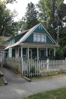
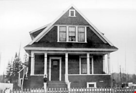
- The D.C. Patterson House is a one and one-half storey plus basement wood-frame Edwardian era residence with a full-width front verandah and symmetrical saddlebag dormers. It is located adjacent to a ravine park and is part of the Winston Gate development.
- Associated Dates
- 1910
- Formal Recognition
- Heritage Designation, Community Heritage Register
- Other Names
- Dugald & Frances Patterson House
- Street View URL
- Google Maps Street View
- Repository
- Burnaby Heritage Planning
- Other Names
- Dugald & Frances Patterson House
- Geographic Access
- 12th Avenue
- Associated Dates
- 1910
- Formal Recognition
- Heritage Designation, Community Heritage Register
- Enactment Type
- Bylaw No. 10062
- Enactment Date
- 11/07/1994
- Description
- The D.C. Patterson House is a one and one-half storey plus basement wood-frame Edwardian era residence with a full-width front verandah and symmetrical saddlebag dormers. It is located adjacent to a ravine park and is part of the Winston Gate development.
- Heritage Value
- This house is significant for its associations with the Patterson family, who were early Burnaby pioneers. Dugald Campbell Patterson (1860-1931) and Frances Mabel Patterson (1872-1960) arrived in 1894 and settled in the Central Park district. In 1910, they relocated to the Edmonds District and built this family residence on Edmonds Street near Kingsway. The Pattersons were community minded citizens who served Burnaby through their involvement with local municipal affairs and politics. Dugald Patterson served as a School Trustee in 1912-13 and was one of the first residents to lobby council to preserve the local ravines as parks. The family name is remembered and honoured by the naming of Patterson Avenue and the Patterson SkyTrain Station located in the Metrotown area. Additionally, the D.C. Patterson House is significant as a fine example of a vernacular Edwardian era family house. The typical design of the Patterson House was taken from an Edwardian era pattern book, and demonstrates how standardized plans were commonly used by local owners and builders to expedite the construction process. This house has survived in an excellent state of preservation. Although moved from its original site, it remains as an intact representation of a middle-class Burnaby residence of the Edwardian era.
- Defining Elements
- Key elements that define the heritage character of the D.C. Patterson House include its: - vernacular residential form, scale and massing as exemplified by its one and one-half storey plus basement height, front gabled roof with hipped return over front verandah, symmetrical saddlebag dormers and rectangular, side hall plan with an asymmetrical front entry - typical Edwardian era construction features such as the deep boxed eaves, lapped wooden siding and cedar shingle roofing - projecting front gable peak, clad in decorative random-coursed square shingles, with eave brackets under and a louvered attic vent - projecting elements on the main floor including a square bay on the east side and a semi-octagonal bay to the west side - full-width open front verandah with irregularly-spaced square columns - closed balustrades with drainage scuppers on the front verandah and rear side porch - regular fenestration, including double hung 1-over-1 wooden-sash windows with proportionately smaller upper sash, triple assembly of windows in the front gable, and leaded glass in main floor front window - original front door with inset bevelled glass light
- Historic Neighbourhood
- Edmonds (Historic Neighbourhood)
- Planning Study Area
- Stride Hill Area
- Function
- Primary Historic--Single Dwelling
- Primary Current--Single Dwelling
- Community
- Burnaby
- Cadastral Identifier
- 003-008-321
- Boundaries
- The D.C. Patterson House is comprised of a single residential lot located at 7106 Eighteenth Avenue, Burnaby.
- Area
- 5176
- Contributing Resource
- Building
- Ownership
- Private
- Street Address
- 7106 18th Avenue
- Street View URL
- Google Maps Street View
Images
Jesse Love House
https://search.heritageburnaby.ca/link/landmark540
- Repository
- Burnaby Heritage Planning
- Description
- The Jesse Love House is a vernacular example of a late Victorian-era wood-frame farmhouse with later Arts and Crafts alterations and additions, that has been relocated to the Burnaby Village Museum. This two-storey house has an L-shaped plan, with a compound gabled roof, overhanging eaves and a lar…
- Associated Dates
- 1893
- Formal Recognition
- Heritage Designation, Community Heritage Register
- Other Names
- Jesse & Martha Love Farmhouse
- Street View URL
- Google Maps Street View
- Repository
- Burnaby Heritage Planning
- Other Names
- Jesse & Martha Love Farmhouse
- Geographic Access
- Deer Lake Avenue
- Associated Dates
- 1893
- Formal Recognition
- Heritage Designation, Community Heritage Register
- Enactment Type
- Bylaw No. 9807
- Enactment Date
- 23/11/1992
- Description
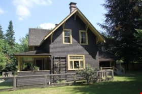
- The Jesse Love House is a vernacular example of a late Victorian-era wood-frame farmhouse with later Arts and Crafts alterations and additions, that has been relocated to the Burnaby Village Museum. This two-storey house has an L-shaped plan, with a compound gabled roof, overhanging eaves and a large wraparound verandah.
- Heritage Value
- The value of the Jesse Love House lies in its comprehensive representation of an early Burnaby farmhouse, and the typical additive growth of a home as the resident family prospered. Jesse Love (1849-1928) and his wife Martha Love (1858-1920) moved to Burnaby in 1893 with their family to start a fruit ranch and market garden on Cumberland Road in the East Burnaby district. Jesse Love was actively involved in community affairs, serving on the Burnaby School Board and also as a District Councillor in 1901 and from 1904-07. The original house was constructed by local builder George Salt and consisted of an entrance hall, dining room, lean-to kitchen, master bedroom and several rooms upstairs. As the family grew and prospered, additions were made to the house including a parlour, more bedrooms upstairs, and a large permanent kitchen. Jesse Love was actively involved in community affairs, and the kitchen became a local gathering spot for political discussion and civic organizations. The verandah, exterior shingle cladding, large windows, running water and electricity were eventually added as well. The heritage value for this house also lies in its interpretive value within the Burnaby Village Museum. The site is an important cultural feature for the interpretation of Burnaby’s heritage to the public. The house was moved to the Burnaby Village Museum in 1988 and both the interior and exterior were restored and interpreted to their 1925 period, including reproduction wallpaper.
- Defining Elements
- The character defining features of the Jesse Love House include its: - irregular form and massing - compound gable roof with cedar shingle cladding - Craftsman-style exterior features such as a shingled exterior and triangular eave brackets - multi-paned double-hung 2-over-2 wooden-sash windows; casement window assemblies with transoms in the Living Room - large wrap-around verandah - interior features such as pressed tin ceilings, original wallpapers and cedar panelled kitchen - reproduction Arts and Crafts parlour document wallpaper and border
- Locality
- Deer Lake Park
- Historic Neighbourhood
- Burnaby Lake (Historic Neighbourhood)
- Planning Study Area
- Morley-Buckingham Area
- Organization
- Burnaby Village Museum
- Builder
- George Salt
- Function
- Primary Current--Museum
- Primary Historic--Single Dwelling
- Community
- Burnaby
- Cadastral Identifier
- P.I.D. No. 011-030-356 Legal Description: Parcel 1, District Lot 79 and District Lot 85, Group 1, New Westminster District, Reference Plan 77594
- Boundaries
- Burnaby Village Museum is comprised of a single municipally-owned property located at 6501 Deer Lake Avenue, Burnaby.
- Area
- 38,488.63
- Contributing Resource
- Building
- Landscape Feature
- Structure
- Ownership
- Public (local)
- Documentation
- Heritage Site Files: PC77000 20. City of Burnaby Planning and Building Department, 4949 Canada Way, Burnaby, B.C., V5G 1M2
- Street Address
- 6501 Deer Lake Avenue
- Street View URL
- Google Maps Street View
Images
Masonic Cemetery
https://search.heritageburnaby.ca/link/landmark622
- Repository
- Burnaby Heritage Planning
- Description
- Cemetery site.
- Associated Dates
- 1924
- Street View URL
- Google Maps Street View
- Repository
- Burnaby Heritage Planning
- Geographic Access
- Halifax Street
- Associated Dates
- 1924
- Description
- Cemetery site.
- Heritage Value
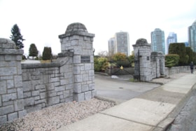
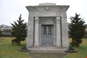
- Tucked into a sloping site in a zone that is now transitional between light industrial and residential uses, the Masonic Cemetery is a beautifully landscaped oasis. Two outstanding features of this cemetery are the Woodward mausoleum, constructed in 1924, and the 1930s entrance gates. These substantial gates are constructed of random-coursed granite, and mark the cemetery’s main entrance off Douglas Road. An elaborate granite mausoleum, built for the prominent Woodward family, is located on axis with the main entry, at the brow of the slope. The Egyptian Revival style of the mausoleum was inspired by the opening of Tutankamun’s tomb just two years earlier, a discovery that sparked world-wide Egyptomania. The Woodward’s department store dynasty was founded by Charles Woodward (1852-1937), who visited Vancouver in 1891 and bought two lots for a store. Woodward’s drug department opened in 1895. In 1901, he took an option on a lot at the corner of Hastings and Abbott Streets and incorporated as Woodward’s Department Stores, which opened in November 1903. The family continued to run the business until 1993, when it went bankrupt and was sold to the Hudson’s Bay Company. A number of the Woodward family are interred here.
- Locality
- Vancouver Heights
- Historic Neighbourhood
- Vancouver Heights (Historic Neighbourhood)
- Planning Study Area
- Willingdon Heights Area
- Area
- 60137.87
- Contributing Resource
- Building
- Landscape Feature
- Ownership
- Private
- Street Address
- 4305 Halifax Street
- Street View URL
- Google Maps Street View
Images
Cascade-Schou Neighbourhood
https://search.heritageburnaby.ca/link/landmark798
- Repository
- Burnaby Heritage Planning
- Associated Dates
- 1955-2008
- Heritage Value
- The Cascade-Schou neighbourhood, sometimes referred to as the Cascade Heights area, includes both the Burnaby General Hospital site, the Discovery Park facilities and is bordered on its eastern boundary by BCIT. Despite these health and science developments, the neighbourhood can still be considered to be a residential community. The housing stock includes single family homes as well as newer multi-family residences that developed throughout the 1980s and 1990s.
- Historic Neighbourhood
- Broadview (Historic Neighbourhood)
- Planning Study Area
- Cascade-Schou Area
Images
Charles R. Shaw House
https://search.heritageburnaby.ca/link/landmark525
- Repository
- Burnaby Heritage Planning
- Description
- The Charles R. Shaw House is a one and one-half storey plus basement wood-frame late Victorian era residence, located on the grounds of the Normanna Rest Home development in East Burnaby, near its original location on this site. Originally a modest vernacular Victorian structure, it has been enlarg…
- Associated Dates
- 1891
- Formal Recognition
- Heritage Designation, Community Heritage Register
- Other Names
- Charles R. & Mary Shaw House
- Street View URL
- Google Maps Street View
- Repository
- Burnaby Heritage Planning
- Other Names
- Charles R. & Mary Shaw House
- Geographic Access
- 12th Avenue
- 4th Street
- 13th Avenue
- Associated Dates
- 1891
- Formal Recognition
- Heritage Designation, Community Heritage Register
- Enactment Type
- Bylaw No. 10739
- Enactment Date
- 06/04/1998
- Description
- The Charles R. Shaw House is a one and one-half storey plus basement wood-frame late Victorian era residence, located on the grounds of the Normanna Rest Home development in East Burnaby, near its original location on this site. Originally a modest vernacular Victorian structure, it has been enlarged and embellished through later additions.
- Heritage Value
- The Shaw House is one of the oldest surviving houses in Burnaby, and is valued as a representation of a typical vernacular pioneer house in Burnaby, and a rare survivor from the late Victorian era. The original portion of the house displays a simplicity of form and detail consistent with early local construction, while the later additions display a more sophisticated approach. Originally built in 1891, this house is valued for its association with first owner, Charles R. Shaw (1834-1916) and Mary D. Shaw (1848-1897), one of Burnaby’s earliest settlers. Born in England, Shaw immigrated to Toronto in 1869, and relocated to New Westminster in 1889, where he worked as an employee of the Mechanic's Mill Company, an early woodworking plant. After moving to Burnaby, he was unanimously elected by acclamation as first reeve (mayor) of the new municipality in 1892. In 1894, Shaw sold his house and farm and moved his family to Kamloops due to his wife Mary's failing health. After Mary died in 1897, the Shaw family returned to Toronto. The Shaw House is additionally valued for its association with a later owner, James Brookes (1884-1953), founder of James Brookes Woodworking Ltd., a mill that was a major employer in East Burnaby. Brookes bought and renovated the house in 1917. In 1927, he built a much larger house on the property (now demolished), and the original house was moved to the corner of the property to serve as a gardener's cottage for Brookes' estate. The additions made to the house at this time employed sash and milled products produced by the Brookes plant. Although altered, this Victorian era residence remains largely intact, with Brookes’s later additions.
- Defining Elements
- Key elements that define the heritage character of the Shaw House include its: - modest vernacular residential form, scale and massing, as exemplified by its one and one-half storey plus basement height, front gabled roof, shed roofed verandah and asymmetrical plan - asymmetrical front entrance - cladding: horizontal wooden drop siding on the original portion of the house; cedar shingles on additions; decorative octagonal cedar shingles in the front gable; original decorated bargeboards at front, with cut-out details - later renovations to the front verandah and side addition which resulted in a partially glazed porch entrance and addition with large window assemblies - square verandah columns - irregular fenestration: double-hung wooden-sash windows in a variety of configurations such as 6-over-1 and 4-over-1 windows in the original portion of the house, 12-over-1 windows, and one 24-over-1 window in the front addition - small window at front entry - fifteen-pane French front entry door - internal red brick chimney with corbelled cap
- Historic Neighbourhood
- East Burnaby (Historic Neighbourhood)
- Planning Study Area
- Edmonds Area
- Function
- Primary Historic--Single Dwelling
- Primary Current--Single Dwelling
- Community
- Burnaby
- Cadastral Identifier
- 003-253-848
- Boundaries
- The Shaw House is comprised of a single residential lot located at 7725 Fourth Street (legal address), Burnaby
- Area
- 9199.27
- Contributing Resource
- Building
- Ownership
- Private
- Names
- Shaw, Charles R
- Street Address
- 7725 4th Street
- Street View URL
- Google Maps Street View
Images
Clinton-Glenwood Neighbourhood
https://search.heritageburnaby.ca/link/landmark841
- Repository
- Burnaby Heritage Planning
- Associated Dates
- 1955-2008
- Heritage Value
- The primarily single-family subdivision and development in the Clinton-Glenwood Neighbourhood occurred during the building boom of the 1950s. Later development fell under the guidelines established in the Royal Oak Community Plan (adopted in 1999) and resulted in an increase in the number of multi-family units.
- Historic Neighbourhood
- Alta Vista (Historic Neighbourhood)
- Planning Study Area
- Clinton-Glenwood Area
Images
Edmonds Neighbourhood
https://search.heritageburnaby.ca/link/landmark704
- Repository
- Burnaby Heritage Planning
- Associated Dates
- 1925-1954
- Heritage Value
- The historic growth of Edmonds as a neighbourhood was based on its strategic location on the early interurban line between Vancouver and New Westminster. Even by 1980 when a survey of the residential neighbourhoods was conducted, a full 25% of homes in the area predated 1930. The 1950s was a period of strong housing development, with both single-family and multi-family units being constructed. Although Burnaby's City Hall was moved from Kingsway and Edmonds in the early 1950s, Edmonds remained an important centre in the community.
- Historic Neighbourhood
- Edmonds (Historic Neighbourhood)
- Planning Study Area
- Stride Avenue Area
Images
Frederick & Edna Cunningham House
https://search.heritageburnaby.ca/link/landmark522
- Repository
- Burnaby Heritage Planning
- Description
- Set back from Douglas Road, the Frederick and Edna Cunningham House is a picturesque wood-frame one and one-half storey British Arts and Crafts-style residence, clad with rough-cast stucco and featuring half-timbering in the gable ends. Set far back on a large east-sloping site in a mature landscap…
- Associated Dates
- 1923
- Formal Recognition
- Heritage Designation, Community Heritage Register
- Street View URL
- Google Maps Street View
- Repository
- Burnaby Heritage Planning
- Geographic Access
- Douglas Road
- Associated Dates
- 1923
- Formal Recognition
- Heritage Designation, Community Heritage Register
- Enactment Type
- Bylaw No. 10470
- Enactment Date
- 04/11/1996
- Description
- Set back from Douglas Road, the Frederick and Edna Cunningham House is a picturesque wood-frame one and one-half storey British Arts and Crafts-style residence, clad with rough-cast stucco and featuring half-timbering in the gable ends. Set far back on a large east-sloping site in a mature landscape setting, it is located in the Douglas Road neighbourhood located in the central valley of Burnaby.
- Heritage Value
- Considered a landmark in the Douglas Road neighbourhood, the Cunningham House is valued as a good example of a British Arts and Crafts-style residence. The house blends into its surroundings, which are extensively landscaped with rockeries, lawns, shrubs, trees and perennial beds. The two majestic copper beech trees, over 60 years old, are among the best specimens of their type to be found in Greater Vancouver and are protected under covenant. The Cunningham property is significant as one of the last estate homes remaining on the old Douglas Road, at one time noted for its beautiful estates set within the rural character of Burnaby’s Central Valley. Insurance agent Frederick Woodman Cunningham (1882-1963) and his wife, Edna Elizabeth Cunningham (1884-1982), built this country residence in 1923. Fred was the only son of James Cunningham, a pioneer of New Westminster who arrived in 1862 and served as the City’s Mayor from 1872 to 1874. The landmark flagpole that once stood in the garden was moved to this site when Fred Cunningham's prestigious family home in New Westminster at Third Avenue and Seventh Street was demolished in 1938. Kept within the family until 1982 and largely maintained in its original condition, the Cunningham House is an excellent example of one of Burnaby's best estate homes from the 1920s and was designated by the City of Burnaby in 1996.
- Defining Elements
- Key elements that define the heritage character of the Cunningham House include its: - location on Douglas Road, in Burnaby’s Central Valley - views from the property to the east and towards the North Shore - residential form, scale and massing as exemplified by its one and one-half storey height and rectangular plan - side gabled roof with front gabled dormer and cedar shingle cladding - British Arts and Crafts elements such as its rough-cast stucco, tapered porch columns, large eave brackets, exposed purlins and half-timbering - irregular fenestration including double-hung 1-over-1 wooden-sash windows, multi-pane wooden-sash casement windows and multiple-assembly windows in the gable ends - front entrance porch with shed roof - two internal red brick chimneys - early cedar-shingled garage at side of house - associated landscape features, including two landmark Copper beech trees and landscaped rockeries at the front of the property
- Historic Neighbourhood
- Burnaby Lake (Historic Neighbourhood)
- Planning Study Area
- Douglas-Gilpin Area
- Function
- Primary Historic--Single Dwelling
- Primary Current--Single Dwelling
- Community
- Burnaby
- Cadastral Identifier
- 003-118-746
- Boundaries
- The Cunningham House is comprised of a single residential lot located at 3555 Douglas Road, Burnaby.
- Area
- 4446.5
- Contributing Resource
- Building
- Ownership
- Private
- Street Address
- 3555 Douglas Road
- Street View URL
- Google Maps Street View
Images
Garden Village Neighbourhood
https://search.heritageburnaby.ca/link/landmark800
- Repository
- Burnaby Heritage Planning
- Associated Dates
- 1955-2008
- Heritage Value
- Bounded by Moscrop Street to the north, Kingsway and Grange to the south, Willingdon to the east and Boundary Road to the west, the Garden Village Neighbourhood is characterised as a primarily residential area that is well-served due to its proximity to commercial, park and business centres. The north-east corner of the neighbourhood is a typical 1950s subdivision of mostly single family homes located on an irregular street pattern, while the remaining areas saw some transition to multi-family housing types throughout the 1970s and up to the current time.
- Historic Neighbourhood
- Central Park (Historic Neighbourhood)
- Planning Study Area
- Garden Village Area
Images
H.T. Ceperley Estate 'Fairacres' Root House
https://search.heritageburnaby.ca/link/landmark527
- Repository
- Burnaby Heritage Planning
- Description
- The ‘Fairacres’ Root House is a long, low one-storey masonry building, measuring 4.6 metres by 9.1 metres, with massively buttressed concrete walls and foundations. Built into sloping ground adjacent to the location of the former greenhouses, the surviving orchard and the kitchen entrance of the ma…
- Associated Dates
- 1908
- Formal Recognition
- Heritage Designation, Community Heritage Register
- Repository
- Burnaby Heritage Planning
- Geographic Access
- Deer Lake Avenue
- Associated Dates
- 1908
- Formal Recognition
- Heritage Designation, Community Heritage Register
- Enactment Type
- Bylaw No. 9807
- Enactment Date
- 23/11/1992
- Description
- The ‘Fairacres’ Root House is a long, low one-storey masonry building, measuring 4.6 metres by 9.1 metres, with massively buttressed concrete walls and foundations. Built into sloping ground adjacent to the location of the former greenhouses, the surviving orchard and the kitchen entrance of the main house, 'Fairacres,' this functional structure was used as a frost-free store for fruit and vegetables for the family's use.
- Heritage Value
- The outbuildings at 'Fairacres' are a rare surviving architecturally-designed ensemble of agricultural structures that exist in complementary harmony with the main estate house. Architect Robert Mackay Fripp (1858-1917), an outspoken advocate of Arts and Crafts design, was retained by the Ceperleys to design several original outbuildings on their estate. The Root House is important as a rare surviving, and exceptionally large, example of this building type in the Vancouver region. Unusual in the fact that an architect designed a building of such modest aspirations, it is also remarkable in its method of construction. The use of concrete as a structural material is one of the earliest in the region and extraordinary for its use on such a modest vernacular outbuilding; root cellars were typically built of loose stone. Built in 1908, the Root House was significantly altered in the 1960s and restored to its original design in 2000. The building is significant as an indicator of the market gardening activity in the area around Deer Lake and of the country-house self-sufficiency practiced by the Ceperley family. The Root House illustrates the cultural, aesthetic, and lifestyle values of the Ceperleys in constructing such a large building for storing their own produce.
- Defining Elements
- The outbuildings at 'Fairacres' are a rare surviving architecturally-designed ensemble of agricultural structures that exist in complementary harmony with the main estate house. Architect Robert Mackay Fripp (1858-1917), an outspoken advocate of Arts and Crafts design, was retained by the Ceperleys to design several original outbuildings on their estate. The Root House is important as a rare surviving, and exceptionally large, example of this building type in the Vancouver region. Unusual in the fact that an architect designed a building of such modest aspirations, it is also remarkable in its method of construction. The use of concrete as a structural material is one of the earliest in the region and extraordinary for its use on such a modest vernacular outbuilding; root cellars were typically built of loose stone. Built in 1908, the Root House was significantly altered in the 1960s and restored to its original design in 2000. The building is significant as an indicator of the market gardening activity in the area around Deer Lake and of the country-house self-sufficiency practiced by the Ceperley family. The Root House illustrates the cultural, aesthetic, and lifestyle values of the Ceperleys in constructing such a large building for storing their own produce.
- Locality
- Deer Lake Park
- Historic Neighbourhood
- Burnaby Lake (Historic Neighbourhood)
- Planning Study Area
- Douglas-Gilpin Area
- Architect
- Robert Mackay Fripp
- Function
- Primary Historic--Outbuilding
- Secondary Historic--Food Storage
- Community
- Burnaby
- Cadastral Identifier
- P.I.D. No. 004-493-311 Legal Description: Block 3 Except: Part subdivided by Plan 26865, District Lot 79, Group 1, New Westminster District, Plan 536
- Boundaries
- ‘Fairacres’ is comprised of a single municipally-owned property located at 6344 Deer Lake Avenue, Burnaby.
- Area
- 17,065.00
- Contributing Resource
- Building
- Landscape Feature
- Ownership
- Public (local)
- Other Collection
- Burnaby Historical Society, Community Archives: Ceperley Photograph Album
- Documentation
- Heritage Site Files: PC77000 20. City of Burnaby Planning and Building Department, 4949 Canada Way, Burnaby, B.C., V5G 1M2
- Street Address
- 6344 Deer Lake Avenue
Images
Kask Brothers
https://search.heritageburnaby.ca/link/landmark684
- Repository
- Burnaby Heritage Planning
- Geographic Access
- Barnet Road
- Associated Dates
- 1925
- Heritage Value
- In 1925, William Kask Sr. and his family purchased land along the Barnet Road and built what became known as Kask's Camp, where cabins were rented out to families working at the Barnet Mill. The family - William Kask Jr., Dave and Jack - went on to expand their business into a lumber and concrete supply company and in 1936, the company was named the Kask Brothers Building Supply Company. A lumber office was established on Curtis Street and the concrete plant was built at the former site of the cabin camp. To a large degree, the camp catered to Immigrants from Nordic countries who were active in the lumber trade. Many Finns felt at home in the camp, as the Kasks spoke Finnish and there were steam baths available.
- Historic Neighbourhood
- Lochdale (Historic Neighbourhood)
- Planning Study Area
- Westridge Area
- Street Address
- 7501 Barnet Road
![Digney family at Bonsor Avenue and family outings, [between 1946 and 1947] thumbnail](/media/Hpo/_Data/_Archives_Moving_Images/_Unrestricted/562-003-15.jpg?width=280)
