![Survey and Subdivision plans in New Westminster District Group 2 - Surrey, ʷməθkʷəy̓əm (Musqueam) Indian Reserve, [190-] thumbnail](/media/hpo/_Data/_BVM_Cartographic_Material/1977/1977_0093_0086_001.jpg?width=280)
Survey and Subdivision plans in New Westminster District Group 2 - Surrey, ʷməθkʷəy̓əm (Musqueam) Indian Reserve
https://search.heritageburnaby.ca/link/museumdescription7055
- Repository
- Burnaby Village Museum
- Date
- [190-]
- Collection/Fonds
- Burnaby Village Museum Map collection
- Description Level
- File
- Physical Description
- 12 plans : graphite and ink on paper and linen; various sizes mounted on 2 sides of cardboard 76 x 102 cm
- Scope and Content
- File consists of a large board with twelve plans (six plans mounted on each side). All plans are located in New Westminster District, Group 2, covering geographic areas within Surrey. Side A: 1. Plan : black ink on paper ; 20.5 x 57.5 cm. Title reads: "Extension of Tram Line / Hospital to Distill…
- Repository
- Burnaby Village Museum
- Collection/Fonds
- Burnaby Village Museum Map collection
- Description Level
- File
- Physical Description
- 12 plans : graphite and ink on paper and linen; various sizes mounted on 2 sides of cardboard 76 x 102 cm
- Scope and Content
- File consists of a large board with twelve plans (six plans mounted on each side). All plans are located in New Westminster District, Group 2, covering geographic areas within Surrey. Side A: 1. Plan : black ink on paper ; 20.5 x 57.5 cm. Title reads: "Extension of Tram Line / Hospital to Distillery St." Scales: Hor: 100 feet = 1 inch; Vert: 20 feet = 1 inch. tram line, hospital to distillery street; 2. Plan : black ink on linen ; 55 x 46.5 cm. (no title). Plan covers New Westminster District, Group 2, Lots 1,2, 3,4, A and B and the ʷməθkʷəy̓əm (Musqueam) Indian Reserve (1868).along the south shore of the Fraser River opposite City of New Westminster. Portion of land is highlighted in blue along the west border of the "ʷməθkʷəy̓əm (Musqueam) Indian Reserve" and between Lot 2 and Lot 1 and survey lines identified as "Mohun's Line" and Hill's Line. Stamp in red ink on plan reads: "Albert J. HIll, M.A. / Civil Engineer / and Provincial Land Surveyor / New Westminster / B.C." (Geographic location: Surrey also formerly known as Brownsville) 3. Plan : black ink on paper ; 34.5 x 23 cm. Title reads: "Lot 51, Gr.2" (in blue crayon). Plan covers area in New Westminster, Group 2, District Lot 51, north of Mud Bay with the Victoria Terminal Railway and Great Northern Railway lines identified. (Geographic location: Surrey) 4. Plan : graphite on paper ; 16.5 x 18 cm. Title reads: "Sec.20, B5N R2W" (underlined in blue crayon). Sketch plan covers and area in New Westmninster District, Group 2. Plan includes initials "RB" in blue crayon. Scale: 5 chains = 1 inch (Geographic location: Surrey) 5. Plan : graphite on paper with annotations in black ink ; 17 x 21 cm. Title reads: "N.W.1/4 Sec.12 TP2" (in blue crayon). Plan covers an area in New Westminster District Group 2 in Section 12, south of Bose Road. Identifying land marks include names: "Bose", "Smith" and "Church Land" Scale: 8 chains = 1 inch (Geographic location: Surrey) 6. Plan : graphite on paper ; 38 x 26.5 cm. (no title) Sketch plan covers areas in Lot 1 and Lot 2 with land identified as "Dominion Government". (could be survey for ʷməθkʷəy̓əm (Musqueam) Indian Reserve) (Geographic location: Surrey also formerly known as Brownsville) Side B: 1. Plan: black ink on paper ; 53.5 x 38 cm. Title reads:"Plan of Subdivision / of / Section 27, / Block 5 North, Range 2 West / New Westminster District". Scale: 4 chains = 1 inch. Includes area subdivided into 18 lots, south of Hjorth Road (104th Avenue) and west of Quible Road with Yale Road running through. Note in blue crayon reads: See also Bd.93) (Geographic location: Surrey) 2. Plan : black ink on paper ; 35 x 28 cm. Title reads: "Plan / of / Block A - L387A / Surrey". Scale: 2 chains = 1 inch. Annotaion in blue crayon reads: "Blk A / Lot 387a_Gr. 2". Plan covers New Westminster District Group 2, Block A, Lot 387 A, south of Parsons Slough and east of Latimer Road (192nd Street). Stamp in red ink on plan reads: "Albert J. HIll, M.A. / Civil Engineer / and Provincial Land Surveyor / New Westminster / B.C." (Geographic location: Surrey) 3. Plan : black ink on linen ; 50 x 42 cm. Title reads: Plan / of part of / Campbell River / running through / the South portion / of N.E. 1/4, Section 8, / Tp. 7, East of Coast Meridian / also / Showing location / of Shingle Mill and Dam". Scale: 100 feet = 1 inch. Plan covers the area in New Westminster District, Township 7, Section 8 with Hall's Prairie Road (184th Street) running through and intersecting with Campbell River. Vegetation, buildings, bridge, shingle mill are identified. (Geographic location: Surrey) 5. Plan : black ink on linen ; 21.5 x 16.5 cm. Title reads: "Sec.32, B5N R2W". Scale: 10 chains = 1 inch. Signed by "Albert J. Hill / B.C.L.S. / Dec. 23, 1908". Note on survey reads: "No actual survey / 40 ac. surveyed". (Geographic location: Surrey) 6. Plan : graphite on paper ; 22 x 15.5 cm. Title reads: "Position 'A5' Subjects / by _McKenzie" [Geographic location: Surrey]
- Creator
- Hill, Albert James
- Names
- ʷməθkʷəy̓əm (Musqueam)
- Accession Code
- HV977.93.86
- Access Restriction
- No restrictions
- Reproduction Restriction
- No known restrictions
- Date
- [190-]
- Media Type
- Cartographic Material
- Scan Resolution
- 600
- Scan Date
- 2023-06-26
- Notes
- Title based on contents of file
- Numeric stamp on edge of board reads: "86"
Zoomable Images
![Survey and Subdivision plans in New Westminster District Group 2 - Surrey, ʷməθkʷəy̓əm (Musqueam) Indian Reserve, [190-] thumbnail](/media/hpo/_Data/_BVM_Cartographic_Material/1977/1977_0093_0086_003_seadragon/1977_0093_0086_003.jpg?w=280)
Survey and Subdivision plans in New Westminster District Group 2 - Surrey, ʷməθkʷəy̓əm (Musqueam) Indian Reserve, [190-]
Zoom into Image
![Survey plans in New Westminster District Group 1 - Maple Ridge, Pitt Meadows, [190-] thumbnail](/media/hpo/_Data/_BVM_Cartographic_Material/1977/1977_0093_0105_001.jpg?width=280)
Survey plans in New Westminster District Group 1 - Maple Ridge, Pitt Meadows
https://search.heritageburnaby.ca/link/museumdescription7074
- Repository
- Burnaby Village Museum
- Date
- [190-]
- Collection/Fonds
- Burnaby Village Museum Map collection
- Description Level
- File
- Physical Description
- 6 plans : graphite and ink on paper and linen; various sizes mounted on 2 sides of cardboard 76 x 102 cm
- Scope and Content
- File consists of a large board with three plans mounted on one side and two on the other side. All plans are located in New Westminster District, Group 2, covering geographic areas within Maple Ridge and Pitt Meadows. Side A: 1. Plan : black ink on linen ; 34 x 86 cm. Title reads: "Survey / of / …
- Repository
- Burnaby Village Museum
- Collection/Fonds
- Burnaby Village Museum Map collection
- Description Level
- File
- Physical Description
- 6 plans : graphite and ink on paper and linen; various sizes mounted on 2 sides of cardboard 76 x 102 cm
- Material Details
- Scales vary (One chain equals 792 inches)
- Indexed number on tape on edge of board reads "105"
- Scope and Content
- File consists of a large board with three plans mounted on one side and two on the other side. All plans are located in New Westminster District, Group 2, covering geographic areas within Maple Ridge and Pitt Meadows. Side A: 1. Plan : black ink on linen ; 34 x 86 cm. Title reads: "Survey / of / Dyke and Waterfront / Sec's 9, 10, 11, 13 & 14 / B5N R1E". Scale: 400 feet = 1 inch. Stamp in red ink on plan reads: "Albert J. Hill, M.A., / Civil Engineer / And / Provincial Land Surveyor, / New Westminster, / B.C." (Geographic location: Pitt Meadows) 2. 2 plans : black ink and graphite on paper ; 34.5 x 51 cm. Titles read: "Survey / For Highway / in / Section 4, Township 15, / New Westminster District. / For Maple Ridge Council." and "Survey / for Highway / in / Section 5, Tp. 15, / New Westminster Dist. / For Maple Ridge Council." Survey plan in Section 5, Township 15, covers SW quarter of Sec. 5, Tp. 15 with "Indian Reserve" (Whonnock Indian Reserve No. 1 - Kwantlen First Nation) identified. Stamp in red ink on plan reads: "Albert J. Hill, M.A., / Civil Engineer / And / Provincial Land Surveyor, / New Westminster, / B.C." Scales vary per drawing: 4 chains = 1 inch and 2 chains = 1 inch. (Geographic location: Maple Ridge) 3. Plan, black ink and graphite on paper ; 41 x 34 cm. Title reads: "Plan / of Subdivision / of / Fractional S.E. Quarter / of Sec. 6, TP. 15 / New Westminster District". Scale: 4 chains = 1 inch tamp in red ink on plan reads: "Albert J. Hill, M.A., / Civil Engineer / And / Provincial Land Surveyor, / New Westminster, / B.C." . Annotation in blue crayon reads: "also Board 122. (Geographic location: Maple Ridge) Side B: 1. Plan : black ink and col. red ink on linen ; 25.5 x 16 cm. Title reads: "Plan of Survey in Lot 398 Gr. 1 / For Lougheed & Abernathy". Scale: 3 chains = 1 inch. Plan is signed by "G.K. Burnett" September 25, 1907. (Geographic location: Maple Ridge) 2. Plan : graphite on paper with annotations in blue ; 91 x 67 cm. Title on survey plan reads: "Lot 441, 439, 438, 440, Gr. 1 / Showing bank of Stave River" (in blue crayon). Survey plan includes lot numbers and identifies "Indian Reserve" (Whonnock Indian Reserve No. 1 - Kwantlen First Nation) (Geographic location: Maple Ridge)
- Accession Code
- HV977.93.105
- Access Restriction
- No restrictions
- Reproduction Restriction
- No known restrictions
- Date
- [190-]
- Media Type
- Cartographic Material
- Scan Resolution
- 600
- Scan Date
- 2023-06-26
- Notes
- Title based on contents of file
Zoomable Images
![Survey plans in New Westminster District Group 1 - Maple Ridge, Pitt Meadows, [190-] thumbnail](/media/hpo/_Data/_BVM_Cartographic_Material/1977/1977_0093_0105_003_seadragon/1977_0093_0105_003.jpg?w=280)
Survey plans in New Westminster District Group 1 - Maple Ridge, Pitt Meadows, [190-]
Zoom into Image
tool
https://search.heritageburnaby.ca/link/museumartifact44871
- Repository
- Burnaby Village Museum
- Accession Code
- BV002.57.22
- Description
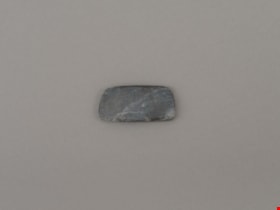
- Chisel, adze or axe blade made of serpentine; rectangular shape.
- Object History
- The donor inherited this artifact from his mother, Katherine Maude (Kitty) Peers, who inherited them from her father, Louis Claude Hill. The artifacts were found on his farm, Brookfield Farm, at Douglas Road and Sperling Avenue (now site of Burnaby Village Museum).
- Culture Phase: Locarno Beach (3520-2200 Before Present) or Marpole (400BC - 400AD)
- Historic Neighbourhood
- Burnaby Lake (Historic Neighbourhood)
Images

Documents
tool
https://search.heritageburnaby.ca/link/museumartifact44875
- Repository
- Burnaby Village Museum
- Accession Code
- BV002.57.26
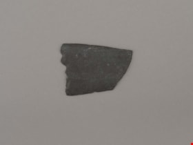
- Description
- Tool, stone, thin and flat; possibly slate. Slightly tapered rectangle shape; narrow sides broken off.
- Object History
- Ground Slate knives are associated with fish processing
- The donor inherited this artifact from his mother, Katherine Maude (Kitty) Peers, who inherited them from her father, Louis Claude Hill. The artifacts were found on his farm, Brookfield Farm, at Douglas Road and Sperling Avenue (now site of Burnaby Village Museum).
- Marpole Culture (400BC - 400AD) or Gulf of Georgia Culture (400 AD – 1800); Essentially these archaeological materials date to the last 2400 years
- Historic Neighbourhood
- Burnaby Lake (Historic Neighbourhood)
Images
Documents
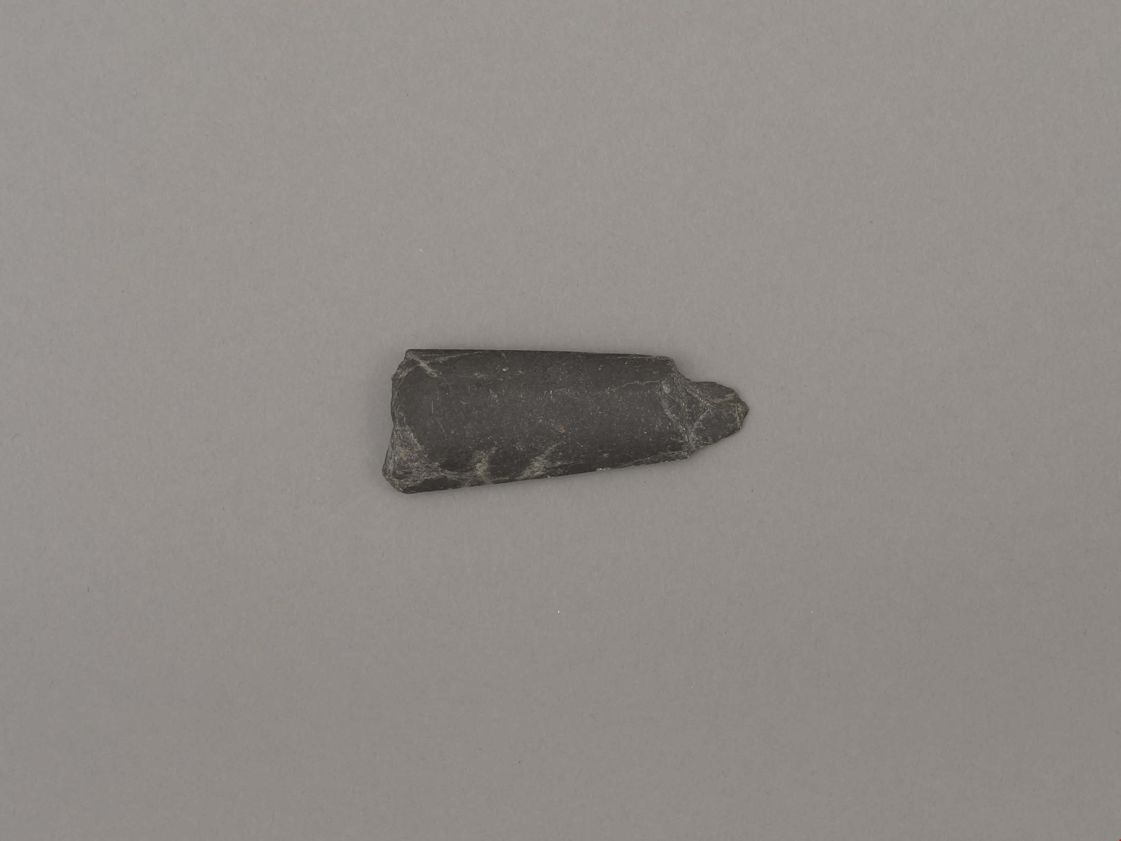
tool or projectile point
https://search.heritageburnaby.ca/link/museumartifact44877
- Repository
- Burnaby Village Museum
- Accession Code
- BV002.57.28
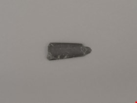
- Description
- Ground stone point; broken end
- Object History
- The donor inherited this artifact from his mother, Katherine Maude (Kitty) Peers, who inherited them from her father, Louis Claude Hill. The artifacts were found on his farm, Brookfield Farm, at Douglas Road and Sperling Avenue (now site of Burnaby Village Museum)..
- Culture Phase: Locarno Beach phase (3520-2200 Before Present)
- Historic Neighbourhood
- Burnaby Lake (Historic Neighbourhood)
Images
Documents
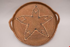
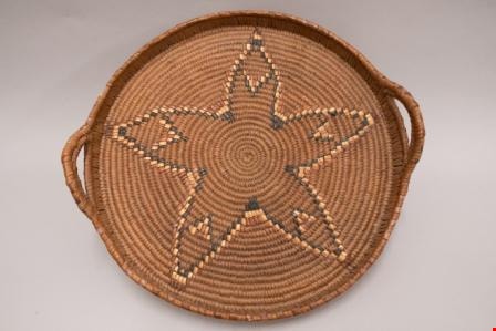
tray
https://search.heritageburnaby.ca/link/museumartifact87627
- Repository
- Burnaby Village Museum
- Accession Code
- BV017.12.1
- Description
- tray; a First Nations made, basketry tray; low sides and two raised handles opposite each other; decorative star or flower pattern woven into the bottom in varying shades of brown; multiple areas of loss around outer sides of rim.
- Object History
- The tray and two baskets (see BV017.11.3 and BV017.11.4) were acquired by the donor's grandparents, Matilda and Robert William Handel, when they were living in North Vancouver. They were made by one of the local First Nations weavers, name unknown.
- Measurements
- Approx. Dia.: 43 cm
Images
Documents

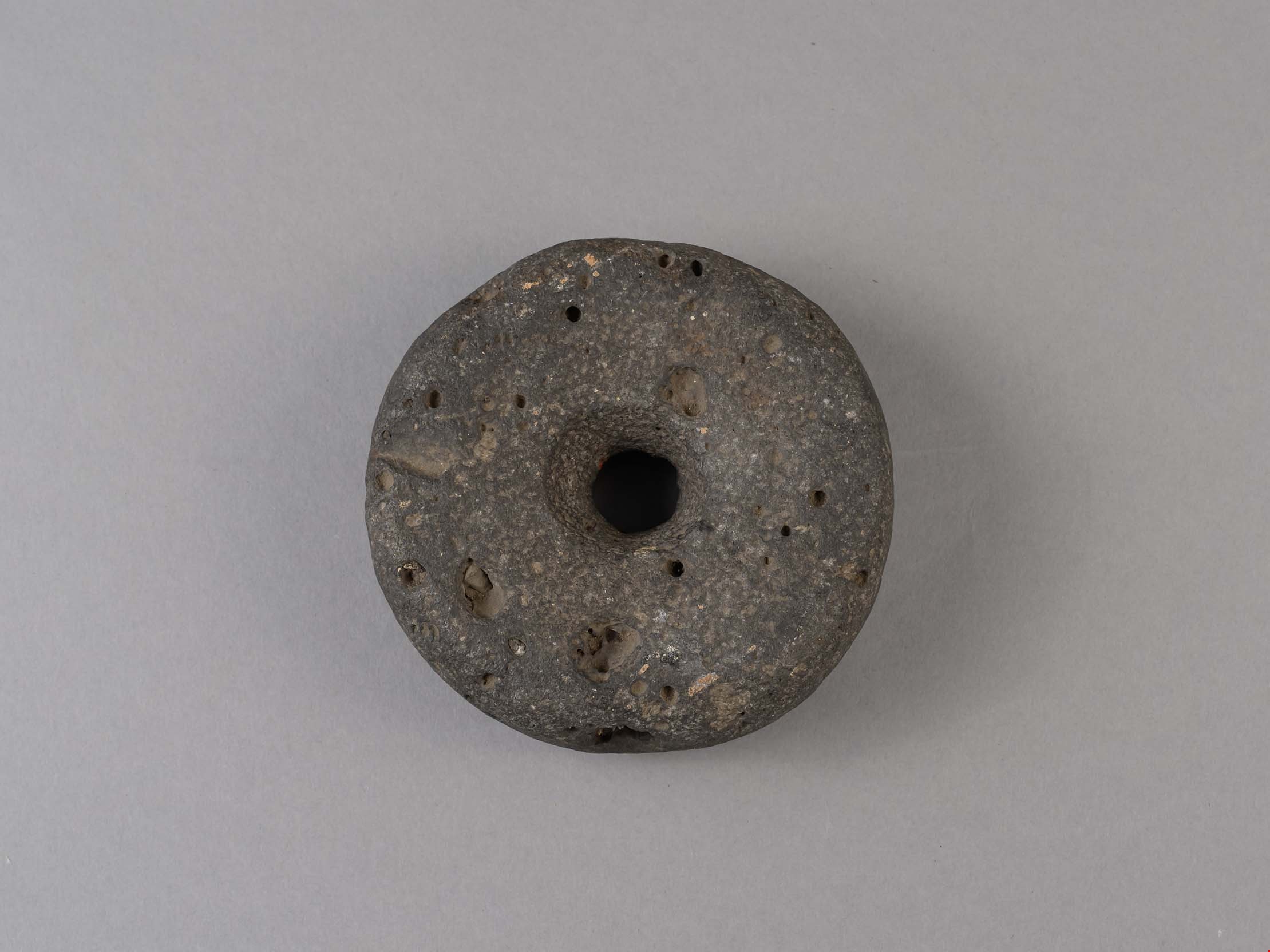
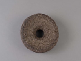
weight
https://search.heritageburnaby.ca/link/museumartifact44855
- Repository
- Burnaby Village Museum
- Accession Code
- BV002.57.3
- Description
- Net weight, round, stone, doughnut-shaped with hole in the middle.
- Object History
- The donor inherited this artifact from his mother, Katherine Maude (Kitty) Peers, who inherited them from her father, Louis Claude Hill. The artifacts were found on his farm, Brookfield Farm, at Douglas Road and Sperling Avenue (now site of Burnaby Village Museum).
- Subjects
- Persons
- Indigenous peoples - British Columbia
- Weights and Measurements Tools and Equipment
- Archeological Specimen
- Historic Neighbourhood
- Burnaby Lake (Historic Neighbourhood)
Images
Documents
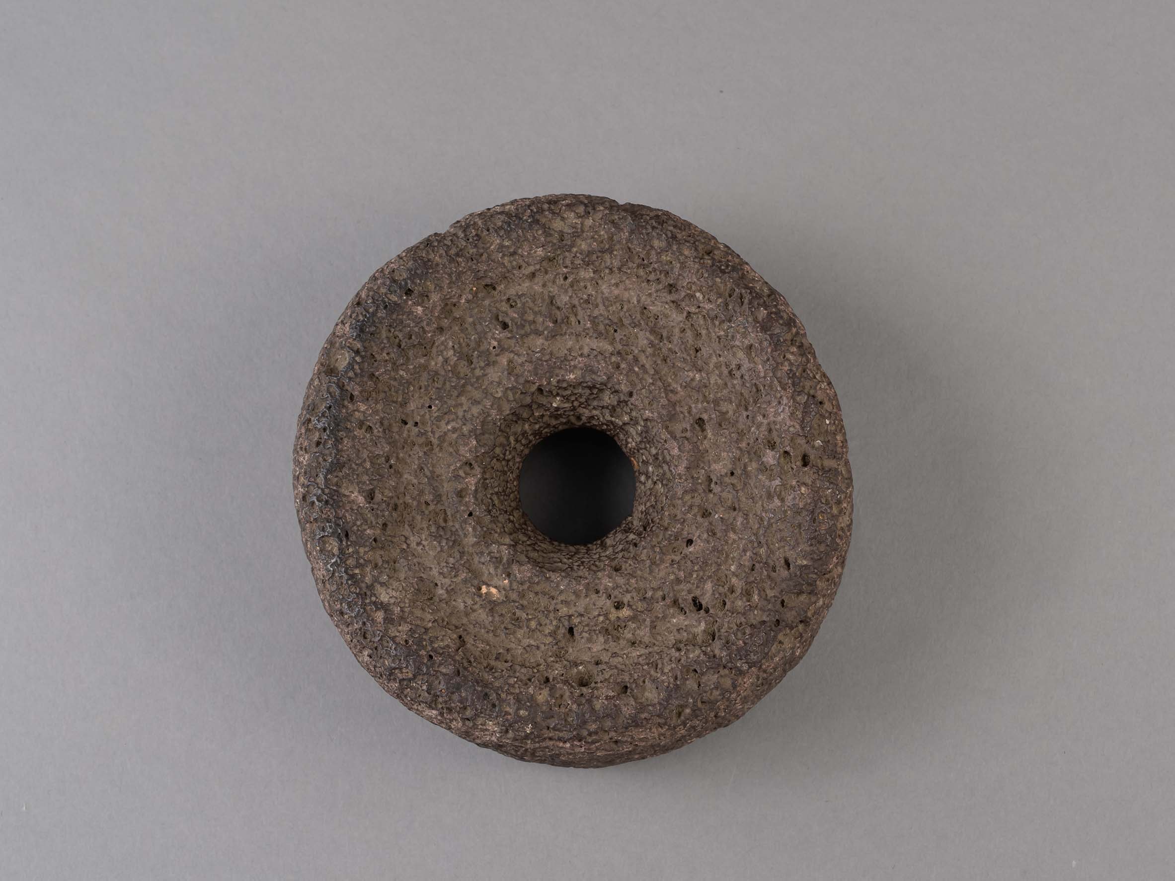
weight
https://search.heritageburnaby.ca/link/museumartifact44856
- Repository
- Burnaby Village Museum
- Accession Code
- BV002.57.4
- Description
- Net weight, round, stone, doughnut-shaped with hole in the middle. Made of volcanic stone.
- Object History
- The donor inherited this artifact from his mother, Katherine Maude (Kitty) Peers, who inherited them from her father, Louis Claude Hill. The artifacts were found on his farm, Brookfield Farm, at Douglas Road and Sperling Avenue (now site of Burnaby Village Museum).
- Subjects
- Persons
- Indigenous peoples - British Columbia
- Weights and Measurements Tools and Equipment
- Archeological Specimen
- Historic Neighbourhood
- Burnaby Lake (Historic Neighbourhood)
Images
Documents
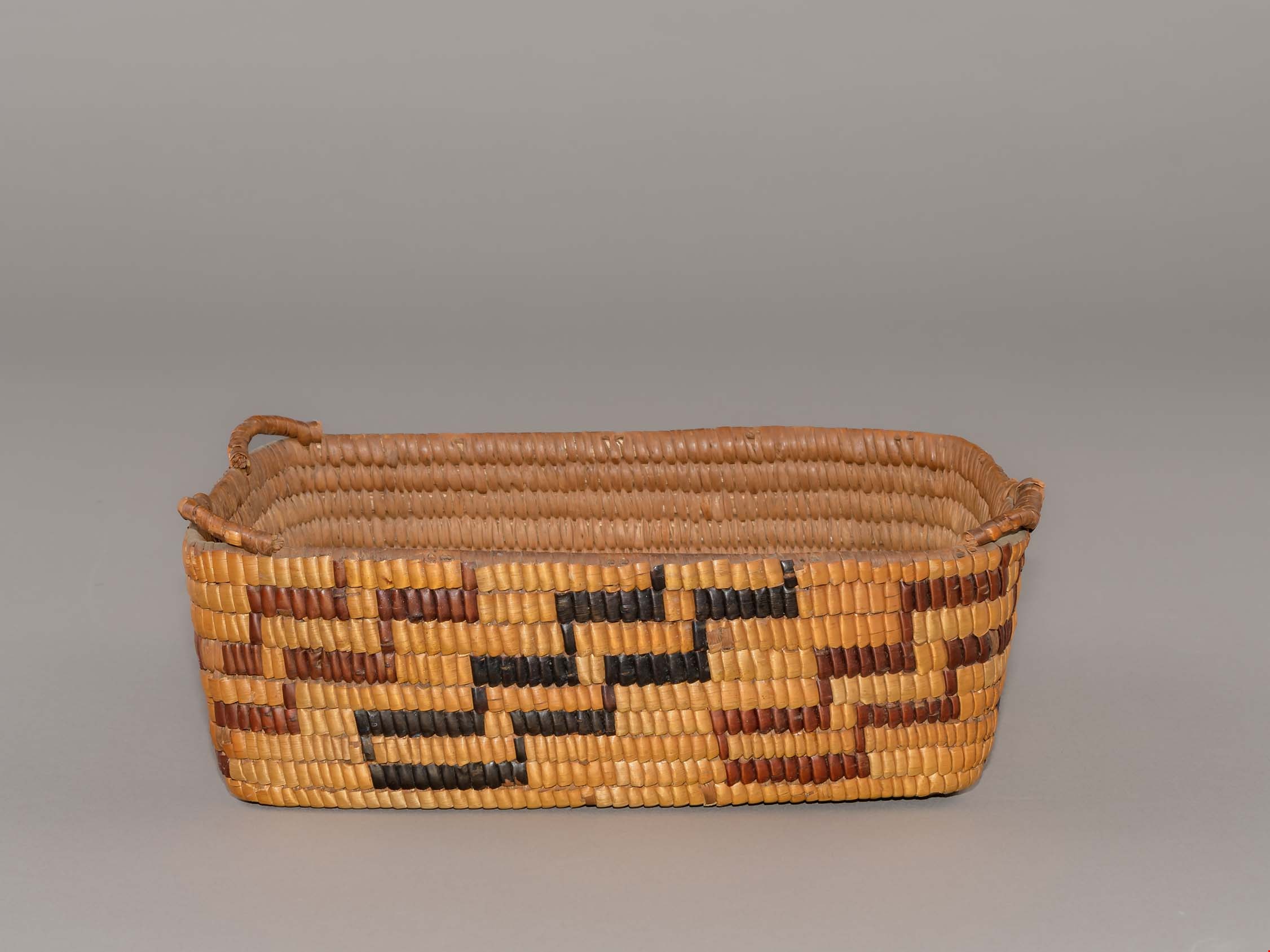
work basket
https://search.heritageburnaby.ca/link/museumartifact27528
- Repository
- Burnaby Village Museum
- Accession Code
- HV974.119.2
- Description
- Rectangular coiled cedar root basket with cedar slat foundation and remnants of a loopwork rim. The shiny appearance of this grass suggests it is canary grass. Black dyed and red cherry bark are used for the zigzag designs. Coast Salish: Sḵwx̱wú7mesh?
- Object History
- The donor reported that the baskets were traded in the early 1920s for clothes by the donor's mother, who lived in North Vancouver. Her mother told her the "Capilano Indians" used to go door to door with their baskets in North Vancouver.
- Zig zags are sometimes referred to as lightening or snake tracks.
- Country Made
- Canada
- Province Made
- British Columbia
- Culture
- Sḵwx̱wú7mesh
Images
Documents

Chinese Canadian history in Burnaby resource guide
https://search.heritageburnaby.ca/link/museumlibrary7608
- Repository
- Burnaby Village Museum
- Publication Date
- [2022]
- Call Number
- 971.1 CHI
often omitted the stories of racialized and
Indigenous peoples. By focusing on the contributions of people of
European origin, these histories create the false impression that
Indigenous and racialized people played a less important role in
history.
Researchers and community members are currently
- Repository
- Burnaby Village Museum
- Collection
- Digital Reference Collection
- Material Type
- Digital Resource
- Accession Code
- BV022.8.1
- Call Number
- 971.1 CHI
- Contributor
- City of Burnaby
- Place of Publication
- Burnaby, BC
- Publisher
- City of Burnaby
- Publication Date
- [2022]
- Physical Description
- 36 p. ; ill. (some col.), maps, ports
- Library Subject (LOC)
- Burnaby (B.C.)--History
- Burnaby (B.C.)--Social Life and Customs
- Chinese Canadians--British Columbia--Burnaby--History
- Chinese--British Columbia--History
- Pharmacy--Canada
- Pharmacy--United States
- Pharmaceutical museums
- Directories
- Subjects
- Persons - Chinese Canadians
- Object History
- Chinese Canadians have contributed to Burnaby’s growth for over a century. The long and intertwining histories between Chinese Canadians, Indigenous people and other communities have shaped the founding of Burnaby and British Columbia. This resource guide was created because their life experiences and important contributions to Burnaby’s development are not widely known.
Images

Digital Books

History of Burnaby Resource Guide
https://search.heritageburnaby.ca/link/museumlibrary7492
- Repository
- Burnaby Village Museum
- Author
- Burnaby Village Museum
- Publication Date
- 2019
understanding
of Burnaby's past has changed considerably as we have considered different
perspectives and evidence.
Over the past few years, Museum researchers have looked into new areas.
We have learned a great deal about the Indigenous peoples who lived in what
became Burnaby and who remain connected to these
- Repository
- Burnaby Village Museum
- Collection
- Digital Reference Collection
- Material Type
- Digital Resource
- Accession Code
- BV019.63.1
- Author
- Burnaby Village Museum
- Place of Publication
- Burnaby, BC
- Publisher
- City of Burnaby
- Publication Date
- 2019
- Physical Description
- 21 p. : ill.
- Library Subject (LOC)
- Burnaby (B.C.)--History
- Directories
- Object History
- Created from research gathered by Burnaby Village Museum staff into the diverse History of Burnaby.
Images

Digital Books

Rooted : Chinese Canadian stories in Burnaby
https://search.heritageburnaby.ca/link/museumlibrary7646
- Repository
- Burnaby Village Museum
- Publication Date
- 2023
- Call Number
- 971.133 ROO
. Some of them used their savings to open
general stores, laundries and cafes in small towns,
serving settler miners and local Indigenous Peoples.
Early Chinese migrants were discriminated against
by federal, provincial and municipal governments.
From 1881 to 1885, more than 17,000 Chinese rail–
road
- Repository
- Burnaby Village Museum
- Collection
- Digital Reference Collection
- Material Type
- Digital Resource
- ISBN
- 978-0-9689849-2-5
- Call Number
- 971.133 ROO
- Contributor
- Fong, Denise
- Lemke, Jane
- Codd, Lisa
- Place of Publication
- Burnaby
- Publisher
- City of Burnaby
- Publication Date
- 2023
- Printer
- Metropolitan Fine Printers
- Physical Description
- 203 p. : ill. ; 30.5 cm
- Library Subject (LOC)
- Chinese Canadians--British Columbia--Burnaby--History
- Race discrimination -- Canada
- Subjects
- Persons - Chinese Canadians
- Agriculture
- Agriculture - Farms
- Persons - Families
- Rights
- Rights - Human Rights
- Social Issues
- Social Issues - Racism
- Notes
- There are two versions of the book: English and Simplified Chinese (left, below) and the other in English and Traditional Chinese (right, below).
- From the late 1800s to the present day, Chinese Canadians have made Burnaby into a more vibrant and livable city. Rooted: Chinese Canadian Stories in Burnaby brings together a collection of diverse stories and photographs from the community, celebrating the legacy and contributions of Burnaby’s Chinese Canadian community spanning over a century. This coffee-table book features oral histories and interviews with descendants of multigenerational family farms, green grocers, corner stores, restaurants, and places of worship. Also included are archival research and community perspectives on anti-Asian racism, community activism, courage, and resilience.
- The publication has been timed to coincide with the 100th anniversary of the introduction of the Chinese Exclusion Act by the Government of Canada in 1923. This federal legislation followed decades of discriminatory legislation by Canada’s federal, provincial and municipal governments that targeted Chinese Canadians by limiting opportunities to live, work and raise families in Canada. The Chinese Exclusion Act banned almost all migration from China and remained in place until 1947. Publishing this book in 2023 is an effort by the City of Burnaby to recognize the impact of discriminatory legislation on Chinese Canadians in our community, including discriminatory bylaws and practices implemented by Burnaby’s early municipal government.
- Edited by Denise Fong (Lead Researcher), Jane Lemke (Burnaby Village Museum Curator) and Lisa Codd (City of Burnaby Heritage Planner).
Images

Digital Books
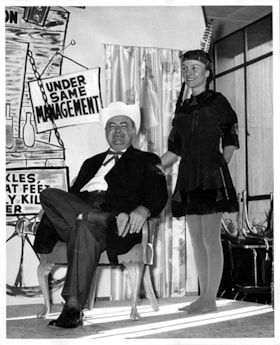
Haskell and woman dressed as an Indigenous person
https://search.heritageburnaby.ca/link/museumdescription17408
- Repository
- Burnaby Village Museum
- Date
- 1959
- Collection/Fonds
- Simpsons-Sears Limited Burnaby fonds
- Description Level
- Item
- Physical Description
- 1 photograph : b&w ; 25.5 x 20.5 cm
- Scope and Content
- Photograph of T. Boyd Haskell, Manager of Simpsons-Sears, Burnaby and an unidentified woman dressed up in cosutme as an indigenous person on stage during a skit. The woman has her hair in two braids and is wearing a head band with a feather poking out of the back. The performance was part of a skit…
- Repository
- Burnaby Village Museum
- Collection/Fonds
- Simpsons-Sears Limited Burnaby fonds
- Description Level
- Item
- Physical Description
- 1 photograph : b&w ; 25.5 x 20.5 cm
- Scope and Content
- Photograph of T. Boyd Haskell, Manager of Simpsons-Sears, Burnaby and an unidentified woman dressed up in cosutme as an indigenous person on stage during a skit. The woman has her hair in two braids and is wearing a head band with a feather poking out of the back. The performance was part of a skit performed by Simpsons-Sears staff. Painted back drop reads "HASKELL'S MEDICINE SHOW / 5 YEARS OF SATISFACTION...".
- History
- The use of costumes by non Indigenous peoples depicting Indigenous peoples are not neutral forms of entertainment. Damaging stereotypes of Indigenous peoples feeds injustice and racism towards Indigenous peoples.
- Subjects
- Performances - Dramatic Performances
- Names
- Simpsons-Sears Limited
- Accession Code
- BV021.26.157
- Access Restriction
- No restrictions
- Reproduction Restriction
- May be restricted by third party rights
- Date
- 1959
- Media Type
- Photograph
- Notes
- Title based on contents of photograph
- Photograph was removed from original scrapbook that included photographs, newspaper clippings, textual records and ephemera
- Note in pencil on verso of photograph reads: "Birthday Sale [sic] 1959"
Images

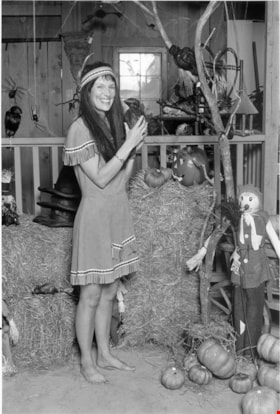
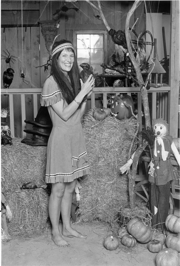
Woman dressed up for Halloween
https://search.heritageburnaby.ca/link/archivedescription78666
- Repository
- City of Burnaby Archives
- Date
- October 25, 1995
- Collection/Fonds
- Burnaby NewsLeader photograph collection
- Description Level
- Item
- Physical Description
- 1 photograph : b&w ; 24.5 x 16.5 cm
- Scope and Content
- Photograph of an unidentified woman in Indigenous dress for Halloween with Halloween decor in the background. The use of costumes by non Indigenous peoples depicting Indigenous peoples are not neutral forms of entertainment. Damaging stereotypes of Indigenous peoples feeds injustice and racism tow…
- Repository
- City of Burnaby Archives
- Date
- October 25, 1995
- Collection/Fonds
- Burnaby NewsLeader photograph collection
- Physical Description
- 1 photograph : b&w ; 24.5 x 16.5 cm
- Description Level
- Item
- Record No.
- 535-0027
- Access Restriction
- No restrictions
- Reproduction Restriction
- No reproduction permitted
- Accession Number
- 2012-11
- Scope and Content
- Photograph of an unidentified woman in Indigenous dress for Halloween with Halloween decor in the background. The use of costumes by non Indigenous peoples depicting Indigenous peoples are not neutral forms of entertainment. Damaging stereotypes of Indigenous peoples feeds injustice and racism towards Indigenous peoples. To give feedback, or for more information, please contact the City of Burnaby Archives.
- Subjects
- Clothing - Costumes
- Media Type
- Photograph
- Photographer
- Ponne, Simone
- Notes
- Title based on contents of photograph
- Note in black and blue ink on recto of photograph reads: "Bby 2769 B Simone / 10/25 BNW p. 11 100%"
- Trim marks and/or reproduction instructions on recto (scan is cropped)
Images
![Central Park siding of Westminster and Vancouver Tramway Co., [between 1891 and 1894] thumbnail](/media/hpo/_Data/_BVM_Images/2021/2021_0029_0001_001.jpg?width=280)
Central Park siding of Westminster and Vancouver Tramway Co.
https://search.heritageburnaby.ca/link/museumdescription17430
- Repository
- Burnaby Village Museum
- Date
- [between 1891 and 1894]
- Collection/Fonds
- Burnaby Village Museum Photograph collection
- Description Level
- Item
- Physical Description
- 1 photograph : b&w albumen print on card ; 20 x 25 cm
- Scope and Content
- Photograph of two streetcars at the Central Park siding of Westminster and Vancouver Tramway Co. Conductors, engineers and riders are posing with the streetcars. The fronts of the streetcars include painted signage reading "12" and "13" and the sides of the streetcars read "WESTMINSTER AND VANCOUVE…
- Repository
- Burnaby Village Museum
- Collection/Fonds
- Burnaby Village Museum Photograph collection
- Description Level
- Item
- Physical Description
- 1 photograph : b&w albumen print on card ; 20 x 25 cm
- Scope and Content
- Photograph of two streetcars at the Central Park siding of Westminster and Vancouver Tramway Co. Conductors, engineers and riders are posing with the streetcars. The fronts of the streetcars include painted signage reading "12" and "13" and the sides of the streetcars read "WESTMINSTER AND VANCOUVER TRAMWAY CO. LTD.".
- History
- Photographers Richard H. Trueman and Norman Caple operated out of Vancouver between 1891 and 1894. The photographers worked between Winnipeg and the west coast of Canada specializing in mountain and railway views, ranch scenes and Indigenous peoples. In 1890, two companies started building electric rail; the Westminster and Vancouver Tramway Co., which undertook the ambitious project of building the first real interurban line from New Westminster to Vancouver, and the Westminster Street Railway. By April 20, 1891, both companies merged to form the Westminster and Vancouver Tramway Company. Streetcar service began in June 1891, travelling on twelve miles of track between New Westminster and eastern Vancouver and running through Burnaby. The line was taken over by the B.C. Electric Railway Company in 1897 until the line was closed in October 1953.
- Accession Code
- BV021.29.1
- Access Restriction
- No restrictions
- Reproduction Restriction
- No known restrictions
- Date
- [between 1891 and 1894]
- Media Type
- Photograph
- Historic Neighbourhood
- Central Park (Historic Neighbourhood)
- Planning Study Area
- Maywood Area
- Scan Resolution
- 600
- Scan Date
- 2021-09-24
- Scale
- 100
- Photographer
- Trueman & Caple
- Notes
- Title taken from recto of photograph
- Inscription on recto of photograph reads: "1138_Central Parkk Sideing of Westminster and Vancouver Tramway Co. _Trueman and Caple. Photo. Vancouver B.C."
- Inscription in gold ink on board reads: "Trueman & Caple_Vancouver, B.C."
Images
![Central Park siding of Westminster and Vancouver Tramway Co., [between 1891 and 1894] thumbnail](/media/hpo/_Data/_BVM_Images/2021/2021_0029_0001_001.jpg)
Tommy Douglas collection
https://search.heritageburnaby.ca/link/archivedescription100683
- Repository
- City of Burnaby Archives
- Date
- 1961-1986
- Collection/Fonds
- Tommy Douglas collection
- Description Level
- Fonds
- Physical Description
- 1.5 cm. of textual records and ephemera.
- Scope and Content
- Fonds consists of materials related to the political career of Tommy Douglas.
- Repository
- City of Burnaby Archives
- Date
- 1961-1986
- Collection/Fonds
- Tommy Douglas collection
- Physical Description
- 1.5 cm. of textual records and ephemera.
- Description Level
- Fonds
- Record No.
- 66688
- Access Restriction
- No restrictions
- Accession Number
- 2022-05
- Scope and Content
- Fonds consists of materials related to the political career of Tommy Douglas.
- History
- Thomas Clement “Tommy” Douglas served as Premier of Saskatchewan from 1944 to 1961, leading the first, and only, Co-operative Commonwealth Federation (CCF) government in Canada. Trained as a Baptist preacher, he became a skilled politician, witty orator, and advocate for social justice, believing political action was the best way to improve Canadians’ lives. As Premier, his government pioneered publicly-funded hospital insurance, which laid the foundations for a national medicare program. He became the first leader of the federal New Democratic Party in 1961, a position he held until 1971, and wielded significant influence defending human rights and strengthening Canada’s social welfare programs. Tommy Douglas was born on October 20, 1904, in Falkirk, Scotland, to a religious, working-class family, who encouraged him to debate politics, religion, and current events while being open to other perspectives. The family moved to Winnipeg, Manitoba, in 1911. His commitment to civil liberties was reinforced after witnessing ‘Bloody Saturday’ during the 1919 Winnipeg General Strike, where several strikers were killed and leaders arrested. He would go on to become an ordained pastor in Weyburn, Saskatchewan, and, in 1933, helped found the CCF, a political coalition of progressive and labour groups with a platform centered on economic reform. Douglas won a federal seat with the CCF in 1935, serving two terms before entering provincial politics. First elected premier of Saskatchewan in 1944, he would serve five terms. His government’s ambitious platform included new administrative structures for economic planning and an innovative program of social reform. It introduced labour and human rights codes and pioneered a new approach to relations between Indigenous Peoples and government. Douglas was also an important influence on the development of medicare in Canada, building on the Saskatchewan tradition of co-operative values to implement the first publicly funded, universally accessible hospital insurance plan in 1947. This was followed by a plan to cover physician services, which concerned doctors worried about regimentation and interference in the doctor-patient relationship. A disruptive 1962 doctor’s strike delayed its implementation, but a compromise was reached and, despite some lingering hostilities, both programs would set the standard for other provinces. This led to federal cost-sharing to facilitate universal, Canada-wide public health care, which remains deeply tied to Canadian identity and values. In 1961, Douglas returned to federal politics as leader of the newly-created New Democratic Party, an alliance between the old CCF and the Canadian Labour Congress. As the third party in Parliament, it was able to use its position to influence minority governments in pushing for the adoption of national social welfare programs, such as medicare and old age pensions. Often the conscience of Parliament on civil liberties, Douglas was one of the few who spoke against the invocation of the War Measures Act during the October Crisis of 1970. Douglas remains a much-admired political figure and the namesake of one of the branches of the Burnaby Public Library. Even those who disagree with his politics admire his pragmatism, oratory skills, integrity, and commitment to social justice. But most of all, Tommy Douglas is an icon for medicare. For his lifetime of service, he was made a Companion of the Order of Canada in 1980. Source: https://www.canada.ca/en/parks-canada/news/2019/03/thomas-clement-tommy-douglas-19041986.html.
- Media Type
- Textual Record