Narrow Results By
Subject
- Aerial Photographs 1
- Agricultural Tools and Equipment 13
- Agricultural Tools and Equipment - Cultivators 2
- Agricultural Tools and Equipment - Gardening Equipment 3
- Agricultural Tools and Equipment - Tractors 1
- Agriculture 44
- Agriculture - Beekeeping 3
- Agriculture - Crops 16
- Agriculture - Dairy 7
- Agriculture - Farms 103
- Agriculture - Fruit and Berries 20
- Agriculture - Orchards 3
Creator
- Association for Living Historical Farms and Agricultural Museums, U.S.A. 1
- Association for Living History, Farm and Agricultural Museums 5
- Ballantyne, James 1
- Beatty Bros Limited 1
- Brittain, John, 1849-1913 1
- Bullen, Harry Elder 1
- Burch, D. S. (Dallas Stockwell), 1886- 1
- Burnaby Community Heritage Commission 1
- Burnaby, Robert, 1828-1878 1
- Burnaby Village Museum 14
- Canada. Department of Agriculture 1
- Canadian Organic Growers 4
Person / Organization
- A & H Plastering and Stucco 1
- Ah Sam 1
- Air Raid Precautions (A.R.P.) 1
- Allen, James Charles 1
- Barnes, Hannah Victoria "Girlie" Love 1
- Binning, Dr. Sadhu 1
- Binning, Gurmaje Kaur 1
- Binning, Jagdish 1
- Binning, Jit Singh 1
- Borstal School 2
- British Columbia Organization to Fight Racism 1
- Burnaby Central Secondary School 1

Eating your way through Burnaby: A look at Chinese Canadian history through food
https://search.heritageburnaby.ca/link/museumdescription14762
- Repository
- Burnaby Village Museum
- Date
- 27 Oct. 2020
- Collection/Fonds
- Burnaby Village Museum fonds
- Description Level
- Item
- Physical Description
- 1 video recording (mp4) (61 min., 56 sec.) : digital, col., sd., stereo ; 29 fps
- Scope and Content
- Item consists of a video recording of a live Zoom webinar hosted by Kate Petrusa, Burnaby Village Museum assistant curator. The webinar is titled "Eating your way through Burnaby: A look at Chinese Canadian history through food" and is presented by Denise Fong, Planning Assistant for the City of Bu…
- Repository
- Burnaby Village Museum
- Collection/Fonds
- Burnaby Village Museum fonds
- Description Level
- Item
- Physical Description
- 1 video recording (mp4) (61 min., 56 sec.) : digital, col., sd., stereo ; 29 fps
- Material Details
- Presenter: Denise Fong
- Host: Kate Petrusa
- Date of Presentation: October 27 7:00 pm - 8:00 pm
- Total Number of tracks: 1
- Total Length of all tracks:61 min., 56 sec.
- Recording Device: Zoom video communication platform
- Scope and Content
- Item consists of a video recording of a live Zoom webinar hosted by Kate Petrusa, Burnaby Village Museum assistant curator. The webinar is titled "Eating your way through Burnaby: A look at Chinese Canadian history through food" and is presented by Denise Fong, Planning Assistant for the City of Burnaby. The zoom webinar is the seventh in a collection of seven "Burnaby Neighbourhood Speaker series" webinars that were presented and made available to the public between September 29 and October 27, 2020. The live webinar and recording was also made available on the Burnaby Village Museum's facebook page. In this webinar, Denise Fong talks about how Chinese Canadians have played a key role in supplying food to Burnaby’s community through their participation in the local market gardening, green grocer, and restaurant industries. The presentation is supported with historical maps, photographs, documents, census records and stories from recent research on the 1960s-1970s period in Burnaby’s Big Bend and Capitol Hill neighborhoods. In her presentation, Denise also talks about the history of Chinese Immigration in Canada including the political circumstances and legal barriers that Chinese migrants faced in the late nineteenth to early twentieth century. Denise highlights specific Chinese Canadian family farms in Burnaby including; the Jung family farm located on 5460 Douglas Road operated by Jung Chong and his wife Jung Gee Shee; "Hop On Farms" located on Marine Drive, operated by Chan Kow Hong, Sui Ha Hong and family; the Tong Yip Farm located on Byrne Road operated by D.T. "George" Yip and his wife, Yip Chow Won Tai. Denise also highlights her recent research regarding Chinese Canadian corner stores and green grocers in Burnaby including; The Lee Kee grocery store located at 3824 East Hastings Street, owned and operated by Yow Lee Ko and his wife Say Jan Chan; the Burnaby Market located at 3942 East Hastings Street, owned and operated by Chin Yin Wong; the Quon Bros. located at 3702 East Hastings Street.; Y. Hoy Produce Co. located at 4092 East Hastings Street operated by Hoy Yen; Louie's Food Basket located at 5886 South East Marine Drive operated by Hoy Bew Louie, his wife Poy Yee and later by thier son Bing Louie and Tommy's Market located in Burnaby's Edmonds neighbourhood, operated by Tommy Chu. Denise also provides a detailed history of Tommy Chu and family who owned and operated Tommy's Market. Denise tells of how in the early 1970s, Chinese grocers in the lower mainland came together and formed the Lower Mainland Independent Grocers Association and Lower Mainland Grocers Co-Op. The organization was formed to protect the rights and promote businesses of independent grocers. In closing, Denise explains how her research of Chinese Canadian history in Burnaby continues and by the end of the project, the information will be made accessible in the form of a publication.
- Creator
- Burnaby Village Museum
- Subjects
- Persons - Chinese Canadians
- Social Issues - Discrimination
- Agriculture - Farms
- Social Issues - Racism
- Buildings - Commercial - Grocery Stores
- Names
- Fong, Denise
- Jung, Chung Chong
- Tommy's Produce
- Lee Kee Grocery
- Louie's Food Basket
- Louie, Hoy Bew
- Jung, Gee Shee
- Hong, Chan Kow
- Hong, Sui Ha
- Yip, D.T. "George"
- Yip, Chow Won Tai
- Ko, Yow Lee
- Ko, Chan Say Jan
- Burnaby Market
- Wong, Chin Yin
- Quon Bros.
- Y. Hoy Produce Co.
- Yen, Hoy
- Louie, Poy Yee
- Louie, Bing
- Chu, Tommy
- Chu, Sharon
- Chu, Calvin
- Responsibility
- Petrusa, Kate
- Geographic Access
- Hastings Street
- Accession Code
- BV020.29.7
- Access Restriction
- No restrictions
- Reproduction Restriction
- No known restrictions
- Date
- 27 Oct. 2020
- Media Type
- Moving Images
- Historic Neighbourhood
- Fraser Arm (Historic Neighbourhood)
- Vancouver Heights (Historic Neighbourhood)
- Planning Study Area
- Big Bend Area
- Burnaby Heights Area
- Notes
- Title based on contents of video recording
- Video recording was edited for publication on Heritage Burnaby. Original mp4 video recording (BV020.29.7.1) is 72 min., 14 sec.
Images

Video
Eating your way through Burnaby: A look at Chinese Canadian history through food, 27 Oct. 2020
Eating your way through Burnaby: A look at Chinese Canadian history through food, 27 Oct. 2020
https://search.heritageburnaby.ca/media/hpo/_Data/_BVM_Moving_Images/2020_0029_0007_002.mp4
Farm building covered with brambles
https://search.heritageburnaby.ca/link/museumdescription12811
- Repository
- Burnaby Village Museum
- Date
- 1977
- Collection/Fonds
- Century Park Museum Association fonds
- Description Level
- Item
- Physical Description
- 1 photograph : col. slide ; 35 mm
- Scope and Content
- Photograph of a wooden building on the Lubbock farm. The building is overgrown with blackberry bushes.
- Repository
- Burnaby Village Museum
- Collection/Fonds
- Century Park Museum Association fonds
- Description Level
- Item
- Physical Description
- 1 photograph : col. slide ; 35 mm
- Scope and Content
- Photograph of a wooden building on the Lubbock farm. The building is overgrown with blackberry bushes.
- History
- In 1977, Century Park Museum was granted access to the Sprott-Lubbock farm to appraise the heritage buildings for preservation. Buildings that were saved included the old farrier shed (BV985.1240.2) which was also used as a blacksmith shop and the Vorce tram station building (BV985.1240.3) from the old Burnaby Lake Interurban line which was used as a grain storage shed on the property. Segments of the original farmhouse and other out buildings were retained. Other buildings on the site were demolished to make way for a new housing development.
- Subjects
- Agriculture - Farms
- Names
- Lubbock farm
- Geographic Access
- Grandview Highway
- Burris Street
- Street Address
- 7803 Burris Street
- Accession Code
- BV020.5.478
- Access Restriction
- No restrictions
- Reproduction Restriction
- No known restrictions
- Date
- 1977
- Media Type
- Photograph
- Historic Neighbourhood
- Burnaby Lake (Historic Neighbourhood)
- Planning Study Area
- Morley-Buckingham Area
- Scan Resolution
- 2400
- Scan Date
- 13-Mar-20
- Scale
- 100
- Notes
- Title based on contents of photograph
Images

Farm conveniences : a practical hand-book for the farm
https://search.heritageburnaby.ca/link/museumlibrary4874
- Repository
- Burnaby Village Museum
- Collection
- Special Collection
- Material Type
- Book
- Accession Code
- HV982.23.3
- Call Number
- 630 HAL
- Place of Publication
- New York
- Publisher
- Orange Judd
- Publication Date
- 1915
- Physical Description
- 256 p. : ill. ; 19 cm.
- Inscription
- a chart of letters and numbers written in pencil on front pastedown Initials W. F. M. written multiple times and in varying orders on back endpapers
- Library Subject (LOC)
- Agriculture
- Catalogs
- Handbooks, manuals, etc.
- Subjects
- Agriculture
- Notes
- Author's full name and dates is Byron David Halsted, 1852-1918
Farm museum directory : a guide to America's farm past
https://search.heritageburnaby.ca/link/museumlibrary1304
- Repository
- Burnaby Village Museum
- Collection
- Reference Collection
- Material Type
- Book
- Call Number
- 630.074 STE
- Place of Publication
- Lancaster, PA
- Publisher
- Stemgas Pub. Co.
- Publication Date
- 1998
- Physical Description
- 72 p. : ill. ; 22 cm.
- Inscription
- "October 1998", handwritten in ink on front cover and title page.
- Library Subject (LOC)
- Agricultural museums
- Subjects
- Agriculture
- Notes
- " ... compiled in cooperation with the Association for Living Historical Farms & Agricultural Museums, Inc."--T.p. verso.
![Farm with snow, [1927 or 1928] thumbnail](/media/hpo/_Data/_BVM_Images/2022/2022_0032_0335_001.jpg?width=280)
Farm with snow
https://search.heritageburnaby.ca/link/museumdescription19913
- Repository
- Burnaby Village Museum
- Date
- [1927 or 1928]
- Collection/Fonds
- Esther Love Stanley fonds
- Description Level
- Item
- Physical Description
- 1 photograph : b&w ; 6.5 x 11 cm
- Scope and Content
- Photograph of farm house, farm buildings and windmill. The ground is covered with deep snow. The farm is located in Alberta.
- Repository
- Burnaby Village Museum
- Collection/Fonds
- Esther Love Stanley fonds
- Description Level
- Item
- Physical Description
- 1 photograph : b&w ; 6.5 x 11 cm
- Scope and Content
- Photograph of farm house, farm buildings and windmill. The ground is covered with deep snow. The farm is located in Alberta.
- Accession Code
- BV022.32.335
- Access Restriction
- No restrictions
- Reproduction Restriction
- No known restrictions
- Date
- [1927 or 1928]
- Media Type
- Photograph
- Scan Resolution
- 600
- Scan Date
- 2023-06-09
- Notes
- Title based on contents of photograph
- Photograph is part of Esther Love Stanley photograph album 1 (BV022.32.1)
- Note in black ink on verso of photograph reads: "1927-28"
Images
![Farm with snow, [1927 or 1928] thumbnail](/media/hpo/_Data/_BVM_Images/2022/2022_0032_0335_001.jpg)

Farrier shed on Lubbock farm
https://search.heritageburnaby.ca/link/museumdescription12816
- Repository
- Burnaby Village Museum
- Date
- 1977
- Collection/Fonds
- Century Park Museum Association fonds
- Description Level
- Item
- Physical Description
- 1 photograph : col. slide ; 35 mm
- Scope and Content
- Photograph of the farrier shed on Lubbock family farm. The farrier shed was moved to Heritage Village in 1977 and converted to a Tinsmith shop.
- Repository
- Burnaby Village Museum
- Collection/Fonds
- Century Park Museum Association fonds
- Description Level
- Item
- Physical Description
- 1 photograph : col. slide ; 35 mm
- Scope and Content
- Photograph of the farrier shed on Lubbock family farm. The farrier shed was moved to Heritage Village in 1977 and converted to a Tinsmith shop.
- History
- In 1977, Century Park Museum was granted access to the Sprott-Lubbock farm to appraise the heritage buildings for preservation. Buildings that were saved included the old farrier shed (BV985.1240.2) which was also used as a blacksmith shop and the Vorce tram station building (BV985.1240.3) from the old Burnaby Lake Interurban line which was used as a grain storage shed on the property. Segments of the original farmhouse and other out buildings were retained. Other buildings on the site were demolished to make way for a new housing development.
- Subjects
- Agriculture - Farms
- Names
- Lubbock farm
- Geographic Access
- Grandview Highway
- Burris Street
- Street Address
- 7803 Burris Street
- Accession Code
- BV020.5.483
- Access Restriction
- No restrictions
- Reproduction Restriction
- No known restrictions
- Date
- 1977
- Media Type
- Photograph
- Historic Neighbourhood
- Burnaby Lake (Historic Neighbourhood)
- Planning Study Area
- Morley-Buckingham Area
- Scan Resolution
- 2400
- Scan Date
- 13-Mar-20
- Scale
- 100
- Notes
- Title based on contents of photograph
Images


Farrier shed on Lubbock farm
https://search.heritageburnaby.ca/link/museumdescription12817
- Repository
- Burnaby Village Museum
- Date
- 1977
- Collection/Fonds
- Century Park Museum Association fonds
- Description Level
- Item
- Physical Description
- 1 photograph : col. slide ; 35 mm
- Scope and Content
- Photograph of the farrier shed on Lubbock family farm. The farrier shed was moved to Heritage Village in 1977 and converted to a Tinsmith shop.
- Repository
- Burnaby Village Museum
- Collection/Fonds
- Century Park Museum Association fonds
- Description Level
- Item
- Physical Description
- 1 photograph : col. slide ; 35 mm
- Scope and Content
- Photograph of the farrier shed on Lubbock family farm. The farrier shed was moved to Heritage Village in 1977 and converted to a Tinsmith shop.
- History
- In 1977, Century Park Museum was granted access to the Sprott-Lubbock farm to appraise the heritage buildings for preservation. Buildings that were saved included the old farrier shed (BV985.1240.2) which was also used as a blacksmith shop and the Vorce tram station building (BV985.1240.3) from the old Burnaby Lake Interurban line which was used as a grain storage shed on the property. Segments of the original farmhouse and other out buildings were retained. Other buildings on the site were demolished to make way for a new housing development.
- Subjects
- Agriculture - Farms
- Names
- Lubbock farm
- Geographic Access
- Grandview Highway
- Burris Street
- Street Address
- 7803 Burris Street
- Accession Code
- BV020.5.484
- Access Restriction
- No restrictions
- Reproduction Restriction
- No known restrictions
- Date
- 1977
- Media Type
- Photograph
- Historic Neighbourhood
- Burnaby Lake (Historic Neighbourhood)
- Planning Study Area
- Morley-Buckingham Area
- Scan Resolution
- 2400
- Scan Date
- 13-Mar-20
- Scale
- 100
- Notes
- Title based on contents of photograph
Images


Fence and field
https://search.heritageburnaby.ca/link/museumdescription12788
- Repository
- Burnaby Village Museum
- Date
- 1977
- Collection/Fonds
- Century Park Museum Association fonds
- Description Level
- Item
- Physical Description
- 1 photograph : col. slide ; 35 mm
- Scope and Content
- Photograph of a rail fence on the Lubbock farm at 7803 Burris Street near Burnaby Lake. The fence divides a road and field.
- Repository
- Burnaby Village Museum
- Collection/Fonds
- Century Park Museum Association fonds
- Description Level
- Item
- Physical Description
- 1 photograph : col. slide ; 35 mm
- Scope and Content
- Photograph of a rail fence on the Lubbock farm at 7803 Burris Street near Burnaby Lake. The fence divides a road and field.
- History
- In 1977, Century Park Museum was granted access to the Sprott-Lubbock farm to appraise the heritage buildings for preservation. Buildings that were saved included the old farrier shed (BV985.1240.2) which was also used as a blacksmith shop and the Vorce tram station building (BV985.1240.3) from the old Burnaby Lake Interurban line which was used as a grain storage shed on the property. Segments of the original farmhouse and other out buildings were retained. Other buildings on the site were demolished to make way for a new housing development.
- Subjects
- Agriculture - Farms
- Names
- Lubbock farm
- Geographic Access
- Grandview Highway
- Burris Street
- Street Address
- 7803 Burris Street
- Accession Code
- BV020.5.465
- Access Restriction
- No restrictions
- Reproduction Restriction
- No known restrictions
- Date
- 1977
- Media Type
- Photograph
- Historic Neighbourhood
- Burnaby Lake (Historic Neighbourhood)
- Planning Study Area
- Morley-Buckingham Area
- Scan Resolution
- 2400
- Scan Date
- 13-Mar-20
- Scale
- 100
- Notes
- Title based on contents of photograph
Images


Film of Julie Lee discussing her family farm in the Big Bend area
https://search.heritageburnaby.ca/link/museumdescription4378
- Repository
- Burnaby Village Museum
- Date
- 6 Oct 2017
- Collection/Fonds
- Burnaby Village Museum fonds
- Description Level
- Item
- Physical Description
- 1 m4v video (13 min., 59 sec.) : digital, 23 fps, col., sd., stereo
- Scope and Content
- Film of Julie Lee discussing her family farm in the Big Bend area of Burnaby during a presentation as part of the "Chinese Canadian Stories" Lecture. This lecture was part of the Burnaby Neighbourhood History Series on October 4, 2017 at the Metrotown branch of the Burnaby Public Library. Julie Lee…
- Repository
- Burnaby Village Museum
- Collection/Fonds
- Burnaby Village Museum fonds
- Description Level
- Item
- Physical Description
- 1 m4v video (13 min., 59 sec.) : digital, 23 fps, col., sd., stereo
- Scope and Content
- Film of Julie Lee discussing her family farm in the Big Bend area of Burnaby during a presentation as part of the "Chinese Canadian Stories" Lecture. This lecture was part of the Burnaby Neighbourhood History Series on October 4, 2017 at the Metrotown branch of the Burnaby Public Library. Julie Lee discusses what life was like growing up on her family farm in the Douglas-Gilpin area, at the corner of Still Creek and Douglas Road in Burnaby.
- History
- Julie Lee is the daughter of Suey Ying Jung (Laura) and Puy Yuen Chan. The couple were married at Fraser Mills in October, 1942. The family owned a farm on Douglas Road near Still Creek in the early 1900s. Their farm was located in front of the Douglas Road interurban tram station.
- Subjects
- Agriculture - Farms
- Accession Code
- BV018.6.1
- Reproduction Restriction
- No known restrictions
- Date
- 6 Oct 2017
- Media Type
- Moving Images
- Historic Neighbourhood
- Burnaby Lake (Historic Neighbourhood)
- Planning Study Area
- Douglas-Gilpin Area
- Notes
- Title based on contents of film
Images

Video
Film of Julie Lee discussing her family farm in the Big Bend area, 6 Oct 2017
Film of Julie Lee discussing her family farm in the Big Bend area, 6 Oct 2017
https://search.heritageburnaby.ca/media/hpo/_Data/_BVM_Moving_Images/2018_0006_0001_001.m4v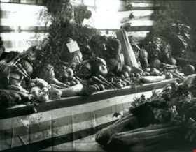
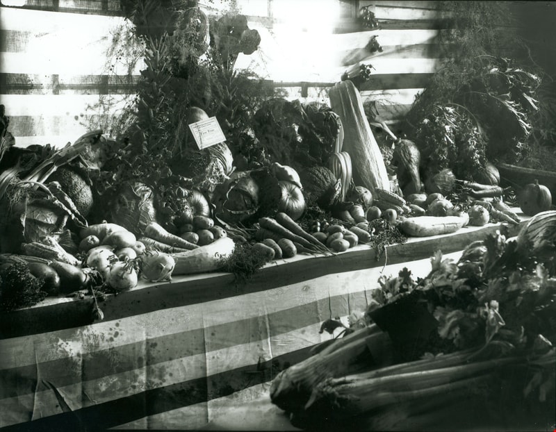
First Prize Vegetable display
https://search.heritageburnaby.ca/link/museumdescription3090
- Repository
- Burnaby Village Museum
- Date
- September 1914
- Collection/Fonds
- Burnaby Village Museum Photograph collection
- Description Level
- Item
- Physical Description
- 1 photograph : b&w glass negative ; 16 x 20.9 cm
- Scope and Content
- Photograph of a vegetable display at the 14th Annual Exhibition of the Central Park Agricultural Association and Farmers' Institute that took place from the 17th to 19th of September, 1914. The display "Surprise Poultry Yards Collection of Vegetables" features the First Prize card on its display.
- Repository
- Burnaby Village Museum
- Collection/Fonds
- Burnaby Village Museum Photograph collection
- Description Level
- Item
- Physical Description
- 1 photograph : b&w glass negative ; 16 x 20.9 cm
- Scope and Content
- Photograph of a vegetable display at the 14th Annual Exhibition of the Central Park Agricultural Association and Farmers' Institute that took place from the 17th to 19th of September, 1914. The display "Surprise Poultry Yards Collection of Vegetables" features the First Prize card on its display.
- Geographic Access
- Central Park
- Imperial Street
- Street Address
- 3883 Imperial Street
- Accession Code
- HV972.11.3
- Access Restriction
- No restrictions
- Reproduction Restriction
- No known restrictions
- Date
- September 1914
- Media Type
- Photograph
- Historic Neighbourhood
- Central Park (Historic Neighbourhood)
- Planning Study Area
- Maywood Area
- Related Material
- For another photograph of a vegetable display at the agricultural exhibition, see HV972.11.17. For a photograph of flower displays at the exhibition, see HV972.11.20
- Scan Resolution
- 300
- Scan Date
- 14/8/2006
- Scale
- 100
- Notes
- Title based on contents of photograph
- 1 b&w contact print accompanying negative
Images
![Flooded Chan family farm, [1948] thumbnail](/media/hpo/_Data/_BVM_Images/2017/2017_0024_0023_001.jpg?width=280)
Flooded Chan family farm
https://search.heritageburnaby.ca/link/museumdescription4069
- Repository
- Burnaby Village Museum
- Date
- [1948]
- Collection/Fonds
- Julie Lee and Cecil Lee family fonds
- Description Level
- Item
- Physical Description
- 1 photograph (tiff) : sepia ; 1000 dpi
- Scope and Content
- Photograph of Suey Ying Jung (Laura) and Puy Yuen Chan in a canoe on the flooded family farm; background contains trees and two buildings; foreground contains a hedge.
- Repository
- Burnaby Village Museum
- Collection/Fonds
- Julie Lee and Cecil Lee family fonds
- Description Level
- Item
- Physical Description
- 1 photograph (tiff) : sepia ; 1000 dpi
- Scope and Content
- Photograph of Suey Ying Jung (Laura) and Puy Yuen Chan in a canoe on the flooded family farm; background contains trees and two buildings; foreground contains a hedge.
- Accession Code
- BV017.24.23
- Access Restriction
- No restrictions
- Reproduction Restriction
- No known restrictions
- Date
- [1948]
- Media Type
- Photograph
- Historic Neighbourhood
- Burnaby Lake (Historic Neighbourhood)
- Planning Study Area
- Douglas-Gilpin Area
- Scan Resolution
- 1000
- Scan Date
- 01-Oct-2017
- Scale
- 100
- Notes
- Title based on contents of photograph
Images
![Flooded Chan family farm, [1948] thumbnail](/media/hpo/_Data/_BVM_Images/2017/2017_0024_0023_001.jpg)
![Flooded Chan family farm, [1948] thumbnail](/media/hpo/_Data/_BVM_Images/2017/201700240024_001.jpg?width=280)
Flooded Chan family farm
https://search.heritageburnaby.ca/link/museumdescription4070
- Repository
- Burnaby Village Museum
- Date
- [1948]
- Collection/Fonds
- Julie Lee and Cecil Lee family fonds
- Description Level
- Item
- Physical Description
- 1 photograph (tiff) : sepia ; 1000 dpi
- Scope and Content
- Photograph of the flooded Chan family farm; buildings and telephone poles throughout the landscape.
- Repository
- Burnaby Village Museum
- Collection/Fonds
- Julie Lee and Cecil Lee family fonds
- Description Level
- Item
- Physical Description
- 1 photograph (tiff) : sepia ; 1000 dpi
- Scope and Content
- Photograph of the flooded Chan family farm; buildings and telephone poles throughout the landscape.
- Accession Code
- BV017.24.24
- Access Restriction
- No restrictions
- Reproduction Restriction
- No known restrictions
- Date
- [1948]
- Media Type
- Photograph
- Historic Neighbourhood
- Burnaby Lake (Historic Neighbourhood)
- Planning Study Area
- Douglas-Gilpin Area
- Scan Resolution
- 1000
- Scan Date
- 01-Oct-2017
- Scale
- 100
- Notes
- Title based on contents of photograph
Images
![Flooded Chan family farm, [1948] thumbnail](/media/hpo/_Data/_BVM_Images/2017/201700240024_001.jpg)
![Fraser Valley Nurseries, [191-?] (date of original), copied 1977 thumbnail](/media/hpo/_Data/_BVM_Images/1977/1977_0099_0017_001.jpg?width=280)
Fraser Valley Nurseries
https://search.heritageburnaby.ca/link/museumdescription575
- Repository
- Burnaby Village Museum
- Date
- [191-?] (date of original), copied 1977
- Collection/Fonds
- Burnaby Village Museum Photograph collection
- Description Level
- Item
- Physical Description
- 1 photograph : b&w ; 20.32 x 25.4 cm
- Scope and Content
- Photograph of the grounds of the Fraser Valley Nurseries. The grounds are fenced with wire and wooden posts.There is a large sign on the left of the photograph that reads "The Fraser Valley Nurseries, Ltd." There are a few barns or sheds on the nursery grounds. Behind the nursery can be seen a la…
- Repository
- Burnaby Village Museum
- Collection/Fonds
- Burnaby Village Museum Photograph collection
- Description Level
- Item
- Physical Description
- 1 photograph : b&w ; 20.32 x 25.4 cm
- Scope and Content
- Photograph of the grounds of the Fraser Valley Nurseries. The grounds are fenced with wire and wooden posts.There is a large sign on the left of the photograph that reads "The Fraser Valley Nurseries, Ltd." There are a few barns or sheds on the nursery grounds. Behind the nursery can be seen a large body of water, most likely Burnaby Lake. The accession register and the inscription on the photograph identify the location as just off Douglas Road (now Canada Way). The annotation on the back of the photograph reads: "Located off Canada Way."
- Subjects
- Agriculture - Farms
- Names
- Fraser Valley Nurseries
- Geographic Access
- Douglas Road
- Canada Way
- Nursery Street
- Burnaby Lake
- Accession Code
- HV977.99.17
- Access Restriction
- No restrictions
- Reproduction Restriction
- May be restricted by third party rights
- Date
- [191-?] (date of original), copied 1977
- Media Type
- Photograph
- Historic Neighbourhood
- Burnaby Lake (Historic Neighbourhood)
- Planning Study Area
- Lakeview-Mayfield Area
- Related Material
- For the right side of the two part panorama of the nurseries, see HV977.99.19
- Scan Resolution
- 600
- Scan Date
- 2023-07-11
- Notes
- Title based on contents of photograph
Images
![Fraser Valley Nurseries, [191-?] (date of original), copied 1977 thumbnail](/media/hpo/_Data/_BVM_Images/1977/1977_0099_0017_001.jpg)
![Fraser Valley Nurseries, [191-?] (date of original), copied 1977 thumbnail](/media/hpo/_Data/_BVM_Images/1977/1977_0099_0019_001.jpg?width=280)
Fraser Valley Nurseries
https://search.heritageburnaby.ca/link/museumdescription577
- Repository
- Burnaby Village Museum
- Date
- [191-?] (date of original), copied 1977
- Collection/Fonds
- Burnaby Village Museum Photograph collection
- Description Level
- Item
- Physical Description
- 1 photograph : b&w ; 20.2 x 25.2 cm print
- Scope and Content
- Photograph of the grounds of the Fraser Valley Nurseries. The grounds are fenced with wire and wooden posts. There are a few barns or sheds on the nursery grounds. Behind the nursery can be seen a large body of water, most likely Burnaby Lake. The accession register identifies the location as j…
- Repository
- Burnaby Village Museum
- Collection/Fonds
- Burnaby Village Museum Photograph collection
- Description Level
- Item
- Physical Description
- 1 photograph : b&w ; 20.2 x 25.2 cm print
- Scope and Content
- Photograph of the grounds of the Fraser Valley Nurseries. The grounds are fenced with wire and wooden posts. There are a few barns or sheds on the nursery grounds. Behind the nursery can be seen a large body of water, most likely Burnaby Lake. The accession register identifies the location as just off Douglas Road (now Canada Way). An annotation on the back of the photo reads: "View Fraser Valley Nurseries."
- Subjects
- Agriculture - Farms
- Names
- Fraser Valley Nurseries
- Geographic Access
- Douglas Road
- Canada Way
- Nursery Street
- Burnaby Lake
- Accession Code
- HV977.99.19
- Access Restriction
- No restrictions
- Reproduction Restriction
- May be restricted by third party rights
- Date
- [191-?] (date of original), copied 1977
- Media Type
- Photograph
- Historic Neighbourhood
- Burnaby Lake (Historic Neighbourhood)
- Planning Study Area
- Lakeview-Mayfield Area
- Related Material
- For the left side of the two part panorama of the nurseries, see HV977.99.17
- Scan Resolution
- 600
- Scan Date
- 2023-07-11
- Notes
- Title based on contents of photograph
Images
![Fraser Valley Nurseries, [191-?] (date of original), copied 1977 thumbnail](/media/hpo/_Data/_BVM_Images/1977/1977_0099_0019_001.jpg)
![Girlie Love raking hay, [192-] thumbnail](/media/hpo/_Data/_BVM_Images/2022/2022_0032_0271_001.jpg?width=280)
Girlie Love raking hay
https://search.heritageburnaby.ca/link/museumdescription19849
- Repository
- Burnaby Village Museum
- Date
- [192-]
- Collection/Fonds
- Esther Love Stanley fonds
- Description Level
- Item
- Physical Description
- 1 photograph : b&w ; 10.5 x 8 cm
- Scope and Content
- Photograph of Hannah Victoria "Girlie" (Love) Barnes holding a hay rake while standing in a field next to a pile of hay. Girlie is dressed in overalls and wearing a straw hat.
- Repository
- Burnaby Village Museum
- Collection/Fonds
- Esther Love Stanley fonds
- Description Level
- Item
- Physical Description
- 1 photograph : b&w ; 10.5 x 8 cm
- Scope and Content
- Photograph of Hannah Victoria "Girlie" (Love) Barnes holding a hay rake while standing in a field next to a pile of hay. Girlie is dressed in overalls and wearing a straw hat.
- Subjects
- Agriculture
- Geographic Features - Fields
- Accession Code
- BV022.32.271
- Access Restriction
- No restrictions
- Reproduction Restriction
- No known restrictions
- Date
- [192-]
- Media Type
- Photograph
- Scan Resolution
- 600
- Scan Date
- 2023-05-14
- Notes
- Title based on contents of photograph
- Photograph is part of Esther Love Stanley photograph album 1 (BV022.32.1)
- Note in white ink on album page beneath photograph reads: "Girlie"
Images
![Girlie Love raking hay, [192-] thumbnail](/media/hpo/_Data/_BVM_Images/2022/2022_0032_0271_001.jpg)
![Gordon and Harry Jung with Philip Mah, [between 1935 and 1945] thumbnail](/media/hpo/_Data/_BVM_Images/2021/2021_0019_0003_001.jpg?width=280)
Gordon and Harry Jung with Philip Mah
https://search.heritageburnaby.ca/link/museumdescription16728
- Repository
- Burnaby Village Museum
- Date
- [between 1935 and 1945]
- Collection/Fonds
- Julie Lee and Cecil Lee family fonds
- Description Level
- Item
- Physical Description
- 1 photograph (jpg)
- Scope and Content
- Photograph of Suey Yook "Gordon" Jung and Suey Cheung "Harry" Jung standing with young, Philip Mah on the boardwalk outside the Jung family home located on the family farm at 5460 Douglas Road (address was changed to 5286 Douglas Road in 1958) in Burnaby. Philip Mah is the son of Lil Mah.
- Repository
- Burnaby Village Museum
- Collection/Fonds
- Julie Lee and Cecil Lee family fonds
- Description Level
- Item
- Physical Description
- 1 photograph (jpg)
- Scope and Content
- Photograph of Suey Yook "Gordon" Jung and Suey Cheung "Harry" Jung standing with young, Philip Mah on the boardwalk outside the Jung family home located on the family farm at 5460 Douglas Road (address was changed to 5286 Douglas Road in 1958) in Burnaby. Philip Mah is the son of Lil Mah.
- Geographic Access
- Vancouver
- Street Address
- 5286 Douglas Road
- Accession Code
- BV021.19.3
- Access Restriction
- No restrictions
- Reproduction Restriction
- No known restrictions
- Date
- [between 1935 and 1945]
- Media Type
- Photograph
- Historic Neighbourhood
- Burnaby Lake (Historic Neighbourhood)
- Planning Study Area
- Douglas-Gilpin Area
- Scan Resolution
- 96
- Scan Date
- April 13, 2021
- Scale
- 100
- Notes
- Title based on contents of photograph
Images
![Gordon and Harry Jung with Philip Mah, [between 1935 and 1945] thumbnail](/media/hpo/_Data/_BVM_Images/2021/2021_0019_0003_001.jpg)
![Gordon Jung and Gee Shee Jung, [between 1935 and 1945] thumbnail](/media/hpo/_Data/_BVM_Images/2021/2021_0019_0001_001.jpg?width=280)
Gordon Jung and Gee Shee Jung
https://search.heritageburnaby.ca/link/museumdescription16726
- Repository
- Burnaby Village Museum
- Date
- [between 1935 and 1945]
- Collection/Fonds
- Julie Lee and Cecil Lee family fonds
- Description Level
- Item
- Physical Description
- 1 photograph (jpg)
- Scope and Content
- Photograph of Suey Yook "Gordon" Jung standing with his mother, Gee Shee Jung on the family farm located at 5460 Douglas Road in Burnaby (address was changed to 5286 Douglas Road in 1958).
- Repository
- Burnaby Village Museum
- Collection/Fonds
- Julie Lee and Cecil Lee family fonds
- Description Level
- Item
- Physical Description
- 1 photograph (jpg)
- Scope and Content
- Photograph of Suey Yook "Gordon" Jung standing with his mother, Gee Shee Jung on the family farm located at 5460 Douglas Road in Burnaby (address was changed to 5286 Douglas Road in 1958).
- Geographic Access
- Vancouver
- Street Address
- 5286 Douglas Road
- Accession Code
- BV021.19.1
- Access Restriction
- No restrictions
- Reproduction Restriction
- No known restrictions
- Date
- [between 1935 and 1945]
- Media Type
- Photograph
- Historic Neighbourhood
- Burnaby Lake (Historic Neighbourhood)
- Planning Study Area
- Douglas-Gilpin Area
- Scan Resolution
- 96
- Scan Date
- April 13, 2021
- Scale
- 100
- Notes
- Title based on contents of photograph
Images
![Gordon Jung and Gee Shee Jung, [between 1935 and 1945] thumbnail](/media/hpo/_Data/_BVM_Images/2021/2021_0019_0001_001.jpg)
![Gordon Jung and Herbert Yep, [between 1935 and 1945] thumbnail](/media/hpo/_Data/_BVM_Images/2021/2021_0019_0004_001.jpg?width=280)
Gordon Jung and Herbert Yep
https://search.heritageburnaby.ca/link/museumdescription16730
- Repository
- Burnaby Village Museum
- Date
- [between 1935 and 1945]
- Collection/Fonds
- Julie Lee and Cecil Lee family fonds
- Description Level
- Item
- Physical Description
- 1 photograph (jpg)
- Scope and Content
- Photograph of Suey Yook "Gordon" Jung and Herbert Yep standing together on the boardwalk outside the Jung family home located on the family farm at 5460 Douglas Road (address was changed to 5286 Douglas Road in 1958) in Burnaby.
- Repository
- Burnaby Village Museum
- Collection/Fonds
- Julie Lee and Cecil Lee family fonds
- Description Level
- Item
- Physical Description
- 1 photograph (jpg)
- Scope and Content
- Photograph of Suey Yook "Gordon" Jung and Herbert Yep standing together on the boardwalk outside the Jung family home located on the family farm at 5460 Douglas Road (address was changed to 5286 Douglas Road in 1958) in Burnaby.
- Geographic Access
- Vancouver
- Street Address
- 5286 Douglas Road
- Accession Code
- BV021.19.4
- Access Restriction
- No restrictions
- Reproduction Restriction
- No known restrictions
- Date
- [between 1935 and 1945]
- Media Type
- Photograph
- Historic Neighbourhood
- Burnaby Lake (Historic Neighbourhood)
- Planning Study Area
- Douglas-Gilpin Area
- Scan Resolution
- 96
- Scan Date
- April 13, 2021
- Scale
- 100
- Notes
- Title based on contents of photograph
Images
![Gordon Jung and Herbert Yep, [between 1935 and 1945] thumbnail](/media/hpo/_Data/_BVM_Images/2021/2021_0019_0004_001.jpg)
![Gordon Jung on family farm, [between 1935 and 1945] thumbnail](/media/hpo/_Data/_BVM_Images/2021/2021_0019_0002_001.jpg?width=280)
Gordon Jung on family farm
https://search.heritageburnaby.ca/link/museumdescription16727
- Repository
- Burnaby Village Museum
- Date
- [between 1935 and 1945]
- Collection/Fonds
- Julie Lee and Cecil Lee family fonds
- Description Level
- Item
- Physical Description
- 1 photograph (jpg)
- Scope and Content
- Photograph of Gordon Jung leaning against a tree on the family farm located at 5460 Douglas Road in Burnaby (address was changed to 5286 Douglas Road in 1958). Buildings along Douglas Road are visible in the background.
- Repository
- Burnaby Village Museum
- Collection/Fonds
- Julie Lee and Cecil Lee family fonds
- Description Level
- Item
- Physical Description
- 1 photograph (jpg)
- Scope and Content
- Photograph of Gordon Jung leaning against a tree on the family farm located at 5460 Douglas Road in Burnaby (address was changed to 5286 Douglas Road in 1958). Buildings along Douglas Road are visible in the background.
- Names
- Jung, Suey Yook "Gordon"
- Geographic Access
- Vancouver
- Street Address
- 5286 Douglas Road
- Accession Code
- BV021.19.2
- Access Restriction
- No restrictions
- Reproduction Restriction
- No known restrictions
- Date
- [between 1935 and 1945]
- Media Type
- Photograph
- Historic Neighbourhood
- Burnaby Lake (Historic Neighbourhood)
- Planning Study Area
- Douglas-Gilpin Area
- Scan Resolution
- 96
- Scan Date
- April 13, 2021
- Scale
- 100
- Notes
- Title based on contents of photograph
Images
![Gordon Jung on family farm, [between 1935 and 1945] thumbnail](/media/hpo/_Data/_BVM_Images/2021/2021_0019_0002_001.jpg)

Horse paddock
https://search.heritageburnaby.ca/link/museumdescription12776
- Repository
- Burnaby Village Museum
- Date
- 1977
- Collection/Fonds
- Century Park Museum Association fonds
- Description Level
- Item
- Physical Description
- 1 photograph : col. slide ; 35 mm
- Scope and Content
- Photograph of the fenced horse paddock and out buildings on the Lubbock farm.
- Repository
- Burnaby Village Museum
- Collection/Fonds
- Century Park Museum Association fonds
- Description Level
- Item
- Physical Description
- 1 photograph : col. slide ; 35 mm
- Scope and Content
- Photograph of the fenced horse paddock and out buildings on the Lubbock farm.
- History
- In 1977, Century Park Museum was granted access to the Sprott-Lubbock farm to appraise the heritage buildings for preservation. Buildings that were saved included the old farrier shed (BV985.1240.2) which was also used as a blacksmith shop and the Vorce tram station building (BV985.1240.3) from the old Burnaby Lake Interurban line which was used as a grain storage shed on the property. Segments of the original farmhouse and other out buildings were retained. Other buildings on the site were demolished to make way for a new housing development.
- Subjects
- Agriculture - Farms
- Names
- Lubbock farm
- Geographic Access
- Grandview Highway
- Burris Street
- Street Address
- 7803 Burris Street
- Accession Code
- BV020.5.453
- Access Restriction
- No restrictions
- Reproduction Restriction
- No known restrictions
- Date
- 1977
- Media Type
- Photograph
- Historic Neighbourhood
- Burnaby Lake (Historic Neighbourhood)
- Planning Study Area
- Morley-Buckingham Area
- Scan Resolution
- 2400
- Scan Date
- 13-Mar-20
- Scale
- 100
- Notes
- Title based on contents of photograph
Images
