Narrow Results By
Subject
- Academic Disciplines 3
- Accidents 15
- Accidents - Automobile Accidents 31
- Accidents - Train Accidents 23
- Adminstrative Groups - Committees 4
- Adornment 83
- Adornment - Jewelry 11
- Adornment - Lapel Pins 84
- Advertising Medium 104
- Advertising Medium - Business Cards 17
- Advertising Medium - Flyer 38
- Advertising Medium - Poster 18
Person / Organization
- A & H Plastering and Stucco 1
- Ah Sam 1
- Barnet Lumber Company 1
- Barnet Mill 1
- Boberg, Elin Anderson 1
- Boberg, Johan Gottfried "John" 1
- Boberg, John 1
- Boundary Road Lumber Mill 1
- Brandrith, Martha Dorothy “Dot” Love 1
- British Columbia Organization to Fight Racism 1
- Brown, Alex 1
- Burnaby Arts Council 1
![Deer Lake Drive, [1918] thumbnail](/media/hpo/_Data/_BVM_Images/1972/1972_0051_0012_001.jpg?width=280)
Deer Lake Drive
https://search.heritageburnaby.ca/link/museumdescription1085
- Repository
- Burnaby Village Museum
- Date
- [1918]
- Collection/Fonds
- Burnaby Village Museum Photograph collection
- Description Level
- Item
- Physical Description
- 1 photograph : b&w ; 12.9 x 32.9 cm
- Scope and Content
- Photograph is a panorama of Deer Lake Drive, including the Ceperley mansion and the surrounding grounds of the home to the left of the picture. The photograph, taken from the water tower, with Burnaby Lake in the background. In the midground, following the horizon line, power poles can be seen. Far…
- Repository
- Burnaby Village Museum
- Collection/Fonds
- Burnaby Village Museum Photograph collection
- Description Level
- Item
- Physical Description
- 1 photograph : b&w ; 12.9 x 32.9 cm
- Scope and Content
- Photograph is a panorama of Deer Lake Drive, including the Ceperley mansion and the surrounding grounds of the home to the left of the picture. The photograph, taken from the water tower, with Burnaby Lake in the background. In the midground, following the horizon line, power poles can be seen. Farm lands are visible leading down to the homes of the Andersons. An annotation on the back of the photo in pencil reads, "Deer Lake Dr." and an annotation in blue pen reads, "1918."
- Geographic Access
- Deer Lake Drive
- Deer Lake Avenue
- Street Address
- 6344 Deer Lake Avenue
- Accession Code
- HV972.51.12
- Access Restriction
- No restrictions
- Reproduction Restriction
- No known restrictions
- Date
- [1918]
- Media Type
- Photograph
- Historic Neighbourhood
- Burnaby Lake (Historic Neighbourhood)
- Planning Study Area
- Douglas-Gilpin Area
- Scan Resolution
- 600
- Scan Date
- 2023-04-04
Images
![Deer Lake Drive, [1918] thumbnail](/media/hpo/_Data/_BVM_Images/1972/1972_0051_0012_001.jpg)
![Development on Big Bend agricultural land, [2000] thumbnail](/media/hpo/_Data/_Archives_Images/_Unrestricted/535/535-1685-2.jpg?width=280)
Development on Big Bend agricultural land
https://search.heritageburnaby.ca/link/archivedescription95885
- Repository
- City of Burnaby Archives
- Date
- [2000]
- Collection/Fonds
- Burnaby NewsLeader photograph collection
- Description Level
- File
- Physical Description
- 2 photographs (tiff) : col.
- Scope and Content
- File contains photographs of Burnaby citizens concerned about industrial and big box retail development in the Big Bend area. One photograph shows Shawn Wade leaning against a fence next to a sign that reads "Western Garden Soil Mushroom Manure Bark Mulch." The other photograph shows Ed Leong holdi…
- Repository
- City of Burnaby Archives
- Date
- [2000]
- Collection/Fonds
- Burnaby NewsLeader photograph collection
- Physical Description
- 2 photographs (tiff) : col.
- Description Level
- File
- Record No.
- 535-1685
- Access Restriction
- No restrictions
- Reproduction Restriction
- No restrictions
- Accession Number
- 2018-12
- Scope and Content
- File contains photographs of Burnaby citizens concerned about industrial and big box retail development in the Big Bend area. One photograph shows Shawn Wade leaning against a fence next to a sign that reads "Western Garden Soil Mushroom Manure Bark Mulch." The other photograph shows Ed Leong holding soil in the fields at Leong's Nursery.
- Media Type
- Photograph
- Photographer
- Bartel, Mario
- Notes
- Title based on caption
- Collected by editorial for use in a November 2000 issue of the Burnaby NewsLeader
- Caption from metadata for 535-1685-1: "Shawn Wade is concerned the City of Burnaby's plans to allow big box retail development in the Big Bend area along Marine Way would threaten the unique agricultural flavor of the area, including nurseries, and the allotment gardens."
- Caption from metadata for 535-1685-2: "Ed Leong, who's run Leong's Nursery since the 1960s, says industrial development in the Big Bend area has already destroyed his ability to grow crops like Chinese vegetables, green onions, lettuce and carrots, as water gets trapped in the already boggy soil by surrounding landfill."
- Historic Neighbourhood
- Fraser Arm (Historic Neighbourhood)
- Planning Study Area
- Big Bend Area
Images
![Development on Big Bend agricultural land, [2000] thumbnail](/media/hpo/_Data/_Archives_Images/_Unrestricted/535/535-1685-2.jpg)
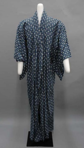
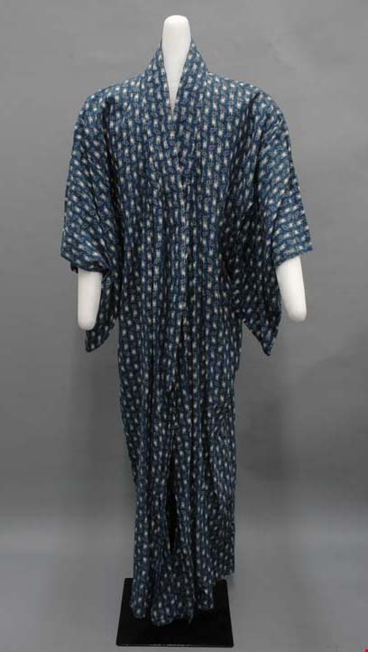
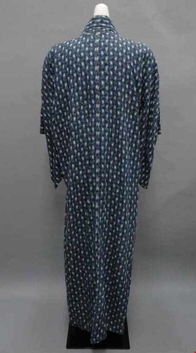
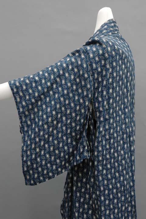
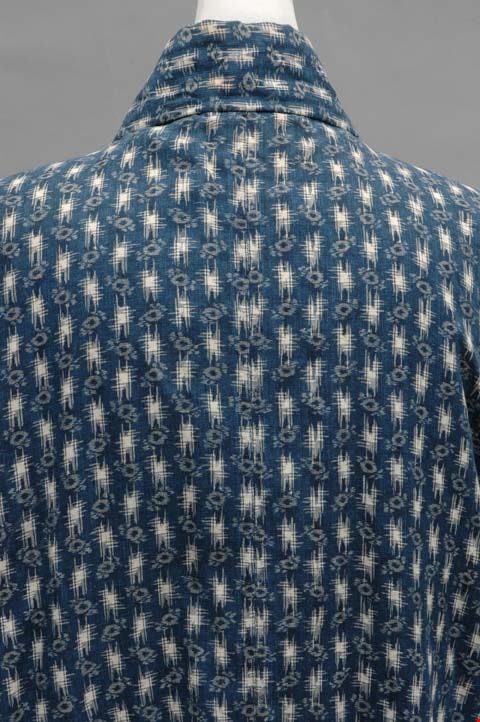
dressing gown
https://search.heritageburnaby.ca/link/museumartifact11595
- Repository
- Burnaby Village Museum
- Accession Code
- BV985.3499.1
- Description
- Dressing gown; blue and white. Japanese informal house dress or "yukata"; cotton; double ikat or "egasuri"
Images


Eating your way through Burnaby: A look at Chinese Canadian history through food
https://search.heritageburnaby.ca/link/museumdescription14762
- Repository
- Burnaby Village Museum
- Date
- 27 Oct. 2020
- Collection/Fonds
- Burnaby Village Museum fonds
- Description Level
- Item
- Physical Description
- 1 video recording (mp4) (61 min., 56 sec.) : digital, col., sd., stereo ; 29 fps
- Scope and Content
- Item consists of a video recording of a live Zoom webinar hosted by Kate Petrusa, Burnaby Village Museum assistant curator. The webinar is titled "Eating your way through Burnaby: A look at Chinese Canadian history through food" and is presented by Denise Fong, Planning Assistant for the City of Bu…
- Repository
- Burnaby Village Museum
- Collection/Fonds
- Burnaby Village Museum fonds
- Description Level
- Item
- Physical Description
- 1 video recording (mp4) (61 min., 56 sec.) : digital, col., sd., stereo ; 29 fps
- Material Details
- Presenter: Denise Fong
- Host: Kate Petrusa
- Date of Presentation: October 27 7:00 pm - 8:00 pm
- Total Number of tracks: 1
- Total Length of all tracks:61 min., 56 sec.
- Recording Device: Zoom video communication platform
- Scope and Content
- Item consists of a video recording of a live Zoom webinar hosted by Kate Petrusa, Burnaby Village Museum assistant curator. The webinar is titled "Eating your way through Burnaby: A look at Chinese Canadian history through food" and is presented by Denise Fong, Planning Assistant for the City of Burnaby. The zoom webinar is the seventh in a collection of seven "Burnaby Neighbourhood Speaker series" webinars that were presented and made available to the public between September 29 and October 27, 2020. The live webinar and recording was also made available on the Burnaby Village Museum's facebook page. In this webinar, Denise Fong talks about how Chinese Canadians have played a key role in supplying food to Burnaby’s community through their participation in the local market gardening, green grocer, and restaurant industries. The presentation is supported with historical maps, photographs, documents, census records and stories from recent research on the 1960s-1970s period in Burnaby’s Big Bend and Capitol Hill neighborhoods. In her presentation, Denise also talks about the history of Chinese Immigration in Canada including the political circumstances and legal barriers that Chinese migrants faced in the late nineteenth to early twentieth century. Denise highlights specific Chinese Canadian family farms in Burnaby including; the Jung family farm located on 5460 Douglas Road operated by Jung Chong and his wife Jung Gee Shee; "Hop On Farms" located on Marine Drive, operated by Chan Kow Hong, Sui Ha Hong and family; the Tong Yip Farm located on Byrne Road operated by D.T. "George" Yip and his wife, Yip Chow Won Tai. Denise also highlights her recent research regarding Chinese Canadian corner stores and green grocers in Burnaby including; The Lee Kee grocery store located at 3824 East Hastings Street, owned and operated by Yow Lee Ko and his wife Say Jan Chan; the Burnaby Market located at 3942 East Hastings Street, owned and operated by Chin Yin Wong; the Quon Bros. located at 3702 East Hastings Street.; Y. Hoy Produce Co. located at 4092 East Hastings Street operated by Hoy Yen; Louie's Food Basket located at 5886 South East Marine Drive operated by Hoy Bew Louie, his wife Poy Yee and later by thier son Bing Louie and Tommy's Market located in Burnaby's Edmonds neighbourhood, operated by Tommy Chu. Denise also provides a detailed history of Tommy Chu and family who owned and operated Tommy's Market. Denise tells of how in the early 1970s, Chinese grocers in the lower mainland came together and formed the Lower Mainland Independent Grocers Association and Lower Mainland Grocers Co-Op. The organization was formed to protect the rights and promote businesses of independent grocers. In closing, Denise explains how her research of Chinese Canadian history in Burnaby continues and by the end of the project, the information will be made accessible in the form of a publication.
- Creator
- Burnaby Village Museum
- Subjects
- Persons - Chinese Canadians
- Social Issues - Discrimination
- Agriculture - Farms
- Social Issues - Racism
- Buildings - Commercial - Grocery Stores
- Names
- Fong, Denise
- Jung, Chung Chong
- Tommy's Produce
- Lee Kee Grocery
- Louie's Food Basket
- Louie, Hoy Bew
- Jung, Gee Shee
- Hong, Chan Kow
- Hong, Sui Ha
- Yip, D.T. "George"
- Yip, Chow Won Tai
- Ko, Yow Lee
- Ko, Chan Say Jan
- Burnaby Market
- Wong, Chin Yin
- Quon Bros.
- Y. Hoy Produce Co.
- Yen, Hoy
- Louie, Poy Yee
- Louie, Bing
- Chu, Tommy
- Chu, Sharon
- Chu, Calvin
- Responsibility
- Petrusa, Kate
- Geographic Access
- Hastings Street
- Accession Code
- BV020.29.7
- Access Restriction
- No restrictions
- Reproduction Restriction
- No known restrictions
- Date
- 27 Oct. 2020
- Media Type
- Moving Images
- Historic Neighbourhood
- Fraser Arm (Historic Neighbourhood)
- Vancouver Heights (Historic Neighbourhood)
- Planning Study Area
- Big Bend Area
- Burnaby Heights Area
- Notes
- Title based on contents of video recording
- Video recording was edited for publication on Heritage Burnaby. Original mp4 video recording (BV020.29.7.1) is 72 min., 14 sec.
Images

Video
Eating your way through Burnaby: A look at Chinese Canadian history through food, 27 Oct. 2020
Eating your way through Burnaby: A look at Chinese Canadian history through food, 27 Oct. 2020
https://search.heritageburnaby.ca/media/hpo/_Data/_BVM_Moving_Images/2020_0029_0007_002.mp4![Edna Bateman Corner family home, [190-] (date of original), copied 1979 thumbnail](/media/hpo/_Data/_BVM_Images/1977/197900320014.jpg?width=280)
Edna Bateman Corner family home
https://search.heritageburnaby.ca/link/museumdescription1788
- Repository
- Burnaby Village Museum
- Date
- [190-] (date of original), copied 1979
- Collection/Fonds
- E.W. Bateman family fonds
- Description Level
- Item
- Physical Description
- 1 photograph : b&w ; 8.5 x 12.4 cm print
- Scope and Content
- Photograph of the family home of Edna Bateman Corner and Raymond Corner at Glenmore, B.C. which is now a part of Kelowna. View of orchard on hill side. There are two houses visible among the fields and fruit trees. Rows of tilled soil and wooden stakes can be seen in the foreground and by the foo…
- Repository
- Burnaby Village Museum
- Collection/Fonds
- E.W. Bateman family fonds
- Description Level
- Item
- Physical Description
- 1 photograph : b&w ; 8.5 x 12.4 cm print
- Scope and Content
- Photograph of the family home of Edna Bateman Corner and Raymond Corner at Glenmore, B.C. which is now a part of Kelowna. View of orchard on hill side. There are two houses visible among the fields and fruit trees. Rows of tilled soil and wooden stakes can be seen in the foreground and by the foot of the hill.
- History
- Edna Bateman is the oldest daughter of Edwin W. Bateman.
- Accession Code
- HV979.32.14
- Access Restriction
- No restrictions
- Reproduction Restriction
- May be restricted by third party rights
- Date
- [190-] (date of original), copied 1979
- Media Type
- Photograph
- Scan Resolution
- 600
- Scan Date
- 2023-09-05
- Notes
- Title based on contents of photograph
- An annotation on the back of the photo reads: "Edna Bateman Corner family home / Glenmore BC, now a part of Kelowna BC / Many years ago." Printed on the original negative and inscribed on the photo, bottom front: "Fruit farm, Kelowna, B.C. / 561."
Images
![Edna Bateman Corner family home, [190-] (date of original), copied 1979 thumbnail](/media/hpo/_Data/_BVM_Images/1977/197900320014.jpg)
![Eleanor and Louise Irwin with Hideko Kokuryo, [1938] (date of original), copied 2004 thumbnail](/media/hpo/_Data/_BVM_Images/2019/2019_0032_0064_001.jpg?width=280)
Eleanor and Louise Irwin with Hideko Kokuryo
https://search.heritageburnaby.ca/link/museumdescription15245
- Repository
- Burnaby Village Museum
- Date
- [1938] (date of original), copied 2004
- Collection/Fonds
- In the Shadow by the Sea collection
- Description Level
- Item
- Physical Description
- 1 photograph (tiff) : 300 dpi
- Scope and Content
- Photograph of Eleanor Irwin Nelson (left), Louise Irwin (right) and Hideko Kokuryo (behind) and dog in front of the Irwin family home at the Barnet Lumber Mill.Eleanor and Louise are seated on a wagon. The front steps and porch of the Irwin home are visible behind them.
- Repository
- Burnaby Village Museum
- Collection/Fonds
- In the Shadow by the Sea collection
- Description Level
- Item
- Physical Description
- 1 photograph (tiff) : 300 dpi
- Scope and Content
- Photograph of Eleanor Irwin Nelson (left), Louise Irwin (right) and Hideko Kokuryo (behind) and dog in front of the Irwin family home at the Barnet Lumber Mill.Eleanor and Louise are seated on a wagon. The front steps and porch of the Irwin home are visible behind them.
- Subjects
- Persons - Japanese Canadians
- Geographic Access
- Burrard Inlet
- Accession Code
- BV019.32.64
- Access Restriction
- No restrictions
- Reproduction Restriction
- No known restrictions
- Date
- [1938] (date of original), copied 2004
- Media Type
- Photograph
- Historic Neighbourhood
- Barnet (Historic Neighbourhood)
- Planning Study Area
- Burnaby Mountain Area
- Notes
- Title based on contents of photograph
Images
![Eleanor and Louise Irwin with Hideko Kokuryo, [1938] (date of original), copied 2004 thumbnail](/media/hpo/_Data/_BVM_Images/2019/2019_0032_0064_001.jpg)
![Elgin Avenue farmhouse, [between 1920 and 1925] (date of original), copied 1986 thumbnail](/media/hpo/_Data/_Archives_Images/_Unrestricted/126/179-005.jpg?width=280)
Elgin Avenue farmhouse
https://search.heritageburnaby.ca/link/archivedescription35034
- Repository
- City of Burnaby Archives
- Date
- [between 1920 and 1925] (date of original), copied 1986
- Collection/Fonds
- Burnaby Historical Society fonds
- Description Level
- Item
- Physical Description
- 1 photograph : b&w ; 8.7 x 12.7 cm print
- Scope and Content
- Photograph of the exterior of an Elgin Avenue farmhouse and surrounding property. The farmhouse is at the left side of the photograph, and a chicken barn is at the right side. This may be 6389 Elgin Avenue.
- Repository
- City of Burnaby Archives
- Date
- [between 1920 and 1925] (date of original), copied 1986
- Collection/Fonds
- Burnaby Historical Society fonds
- Subseries
- Chamberlain family subseries
- Physical Description
- 1 photograph : b&w ; 8.7 x 12.7 cm print
- Description Level
- Item
- Record No.
- 179-005
- Access Restriction
- No restrictions
- Reproduction Restriction
- No known restrictions
- Accession Number
- BHS1986-27
- Scope and Content
- Photograph of the exterior of an Elgin Avenue farmhouse and surrounding property. The farmhouse is at the left side of the photograph, and a chicken barn is at the right side. This may be 6389 Elgin Avenue.
- Media Type
- Photograph
- Notes
- Title based on contents of photograph
- Geographic Access
- Elgin Avenue
- Street Address
- 6389 Elgin Avenue
- Historic Neighbourhood
- Central Park (Historic Neighbourhood)
- Planning Study Area
- Windsor Area
Images
![Elgin Avenue farmhouse, [between 1920 and 1925] (date of original), copied 1986 thumbnail](/media/hpo/_Data/_Archives_Images/_Unrestricted/126/179-005.jpg)
![Elsie Nicholson, [1921] thumbnail](/media/hpo/_Data/_Archives_Images/_Unrestricted/371/375-002.jpg?width=280)
Elsie Nicholson
https://search.heritageburnaby.ca/link/archivedescription38241
- Repository
- City of Burnaby Archives
- Date
- [1921]
- Collection/Fonds
- Burnaby Historical Society fonds
- Description Level
- Item
- Physical Description
- 1 photograph : b&w ; 8 x 12.2 cm
- Scope and Content
- Photograph of Elsie Nicholson standing next to the horse named "Holly" at the Nicholson farm in the area of Boundary Road and the C.N.R. rail line. The barns and farm outbuildings can be seen in the background.
- Repository
- City of Burnaby Archives
- Date
- [1921]
- Collection/Fonds
- Burnaby Historical Society fonds
- Subseries
- Margaret McCallum subseries
- Physical Description
- 1 photograph : b&w ; 8 x 12.2 cm
- Description Level
- Item
- Record No.
- 375-002
- Access Restriction
- No restrictions
- Reproduction Restriction
- No known restrictions
- Accession Number
- BHS1986-42
- Scope and Content
- Photograph of Elsie Nicholson standing next to the horse named "Holly" at the Nicholson farm in the area of Boundary Road and the C.N.R. rail line. The barns and farm outbuildings can be seen in the background.
- Subjects
- Agriculture - Farms
- Occupations - Farmers
- Agriculture - Crops
- Transportation - Horses
- Animals - Dogs
- Transportation - Wagons
- Names
- Nicholson, Elsie
- Media Type
- Photograph
- Notes
- Title based on contents of photograph
- Geographic Access
- Boundary Road
- Street Address
- 2550 Boundary Road
- Historic Neighbourhood
- Broadview (Historic Neighbourhood)
- Planning Study Area
- West Central Valley Area
Images
![Elsie Nicholson, [1921] thumbnail](/media/hpo/_Data/_Archives_Images/_Unrestricted/371/375-002.jpg)
![Ernest and Frank Street, [between 1920 and 1925] thumbnail](/media/hpo/_Data/_Archives_Images/_Unrestricted/205/217-004.jpg?width=280)
Ernest and Frank Street
https://search.heritageburnaby.ca/link/archivedescription36072
- Repository
- City of Burnaby Archives
- Date
- [between 1920 and 1925]
- Collection/Fonds
- Burnaby Historical Society fonds
- Description Level
- Item
- Physical Description
- 1 photograph : col. ; 6 x 11 cm print
- Scope and Content
- Photograph of Ernest Street and his son Frank feeding the animals at the family farm on Cumberland Street.
- Repository
- City of Burnaby Archives
- Date
- [between 1920 and 1925]
- Collection/Fonds
- Burnaby Historical Society fonds
- Subseries
- Helen Street subseries
- Physical Description
- 1 photograph : col. ; 6 x 11 cm print
- Description Level
- Item
- Record No.
- 217-004
- Access Restriction
- No restrictions
- Reproduction Restriction
- No restrictions
- Accession Number
- BHS1989-6
- Scope and Content
- Photograph of Ernest Street and his son Frank feeding the animals at the family farm on Cumberland Street.
- Names
- Street, Ernest
- Street, Frank
- Media Type
- Photograph
- Notes
- Title based on contents of photograph
- 1 col. copy negative accompanying
- Geographic Access
- Cumberland Street
- Historic Neighbourhood
- East Burnaby (Historic Neighbourhood)
- Planning Study Area
- Cariboo-Armstrong Area
Images
![Ernest and Frank Street, [between 1920 and 1925] thumbnail](/media/hpo/_Data/_Archives_Images/_Unrestricted/205/217-004.jpg)
![E.W. Nicholson at his farm, [1921] thumbnail](/media/hpo/_Data/_Archives_Images/_Unrestricted/371/375-001.jpg?width=280)
E.W. Nicholson at his farm
https://search.heritageburnaby.ca/link/archivedescription38240
- Repository
- City of Burnaby Archives
- Date
- [1921]
- Collection/Fonds
- Burnaby Historical Society fonds
- Description Level
- Item
- Physical Description
- 1 photograph : b&w ; 8 x 12.5 cm
- Scope and Content
- Photograph of E.W. Nicholson, haying on his farm at Boundary Road and the Canadian National Railway tracks with his horse "Holly."
- Repository
- City of Burnaby Archives
- Date
- [1921]
- Collection/Fonds
- Burnaby Historical Society fonds
- Subseries
- Margaret McCallum subseries
- Physical Description
- 1 photograph : b&w ; 8 x 12.5 cm
- Description Level
- Item
- Record No.
- 375-001
- Access Restriction
- No restrictions
- Reproduction Restriction
- No known restrictions
- Accession Number
- BHS1986-42
- Scope and Content
- Photograph of E.W. Nicholson, haying on his farm at Boundary Road and the Canadian National Railway tracks with his horse "Holly."
- Subjects
- Agriculture - Farms
- Occupations - Farmers
- Agriculture - Crops
- Transportation - Horses
- Animals - Dogs
- Transportation - Wagons
- Names
- Nicholson, E.W.
- Media Type
- Photograph
- Notes
- Title based on contents of photograph
- Geographic Access
- Boundary Road
- Street Address
- 2550 Boundary Road
- Historic Neighbourhood
- Broadview (Historic Neighbourhood)
- Planning Study Area
- West Central Valley Area
Images
![E.W. Nicholson at his farm, [1921] thumbnail](/media/hpo/_Data/_Archives_Images/_Unrestricted/371/375-001.jpg)
![E.W. Nicholson farm, [1921] thumbnail](/media/hpo/_Data/_Archives_Images/_Unrestricted/371/375-005.jpg?width=280)
E.W. Nicholson farm
https://search.heritageburnaby.ca/link/archivedescription38244
- Repository
- City of Burnaby Archives
- Date
- [1921]
- Collection/Fonds
- Burnaby Historical Society fonds
- Description Level
- Item
- Physical Description
- 1 photograph : b&w ; 8.7 x 12.5 cm
- Scope and Content
- Photograph of cattle grazing in the field on the farm belonging to E.W. Nicholson Farm. The Roman Catholic Boys' School can be seen faintly in the background.
- Repository
- City of Burnaby Archives
- Date
- [1921]
- Collection/Fonds
- Burnaby Historical Society fonds
- Subseries
- Margaret McCallum subseries
- Physical Description
- 1 photograph : b&w ; 8.7 x 12.5 cm
- Description Level
- Item
- Record No.
- 375-005
- Access Restriction
- No restrictions
- Reproduction Restriction
- No known restrictions
- Accession Number
- BHS1986-42
- Scope and Content
- Photograph of cattle grazing in the field on the farm belonging to E.W. Nicholson Farm. The Roman Catholic Boys' School can be seen faintly in the background.
- Subjects
- Agriculture - Farms
- Animals - Cows
- Media Type
- Photograph
- Notes
- Title based on contents of photograph
- Geographic Access
- Boundary Road
- Street Address
- 2550 Boundary Road
- Historic Neighbourhood
- Broadview (Historic Neighbourhood)
- Planning Study Area
- West Central Valley Area
Images
![E.W. Nicholson farm, [1921] thumbnail](/media/hpo/_Data/_Archives_Images/_Unrestricted/371/375-005.jpg)

Farm building covered with brambles
https://search.heritageburnaby.ca/link/museumdescription12811
- Repository
- Burnaby Village Museum
- Date
- 1977
- Collection/Fonds
- Century Park Museum Association fonds
- Description Level
- Item
- Physical Description
- 1 photograph : col. slide ; 35 mm
- Scope and Content
- Photograph of a wooden building on the Lubbock farm. The building is overgrown with blackberry bushes.
- Repository
- Burnaby Village Museum
- Collection/Fonds
- Century Park Museum Association fonds
- Description Level
- Item
- Physical Description
- 1 photograph : col. slide ; 35 mm
- Scope and Content
- Photograph of a wooden building on the Lubbock farm. The building is overgrown with blackberry bushes.
- History
- In 1977, Century Park Museum was granted access to the Sprott-Lubbock farm to appraise the heritage buildings for preservation. Buildings that were saved included the old farrier shed (BV985.1240.2) which was also used as a blacksmith shop and the Vorce tram station building (BV985.1240.3) from the old Burnaby Lake Interurban line which was used as a grain storage shed on the property. Segments of the original farmhouse and other out buildings were retained. Other buildings on the site were demolished to make way for a new housing development.
- Subjects
- Agriculture - Farms
- Names
- Lubbock farm
- Geographic Access
- Grandview Highway
- Burris Street
- Street Address
- 7803 Burris Street
- Accession Code
- BV020.5.478
- Access Restriction
- No restrictions
- Reproduction Restriction
- No known restrictions
- Date
- 1977
- Media Type
- Photograph
- Historic Neighbourhood
- Burnaby Lake (Historic Neighbourhood)
- Planning Study Area
- Morley-Buckingham Area
- Scan Resolution
- 2400
- Scan Date
- 13-Mar-20
- Scale
- 100
- Notes
- Title based on contents of photograph
Images

![Farmhouse and field, [194-] thumbnail](/media/hpo/_Data/_BVM_Images/2022/2022_0032_0498_001.jpg?width=280)
Farmhouse and field
https://search.heritageburnaby.ca/link/museumdescription20076
- Repository
- Burnaby Village Museum
- Date
- [194-]
- Collection/Fonds
- Esther Love Stanley fonds
- Description Level
- Item
- Physical Description
- 1 photograph : b&w ; 6.5 x 6.5 cm
- Scope and Content
- Photograph of farmhouse surrounded by field. Barn is visible in the background.
- Repository
- Burnaby Village Museum
- Collection/Fonds
- Esther Love Stanley fonds
- Description Level
- Item
- Physical Description
- 1 photograph : b&w ; 6.5 x 6.5 cm
- Scope and Content
- Photograph of farmhouse surrounded by field. Barn is visible in the background.
- Subjects
- Agriculture - Farms
- Accession Code
- BV022.32.498
- Access Restriction
- No restrictions
- Reproduction Restriction
- No known restrictions
- Date
- [194-]
- Media Type
- Photograph
- Scan Resolution
- 600
- Scan Date
- 2023-07-25
- Notes
- Title based on contents of photograph
- Photograph is part of Esther Love Stanley photograph album 2 (BV032.22.431)
Images
![Farmhouse and field, [194-] thumbnail](/media/hpo/_Data/_BVM_Images/2022/2022_0032_0498_001.jpg)
![Farmland, [190-] (date of original), copied 1977 thumbnail](/media/hpo/_Data/_BVM_Images/1977/1977_0123_0009_001.jpg?width=280)
Farmland
https://search.heritageburnaby.ca/link/museumdescription603
- Repository
- Burnaby Village Museum
- Date
- [190-] (date of original), copied 1977
- Collection/Fonds
- Burnaby Village Museum Photograph collection
- Description Level
- Item
- Physical Description
- 1 photograph : b&w ; 20.2 x 25.2 cm print
- Scope and Content
- Photograph of cultivated farmlands and rows of different kinds of crops. In the centre are low lying plants, possibly strawberries, and to the left, there are tall deciduous trees. To the right are waist high shrub-like trees. There are workers harvesting from this crop, that could possibly be r…
- Repository
- Burnaby Village Museum
- Collection/Fonds
- Burnaby Village Museum Photograph collection
- Description Level
- Item
- Physical Description
- 1 photograph : b&w ; 20.2 x 25.2 cm print
- Scope and Content
- Photograph of cultivated farmlands and rows of different kinds of crops. In the centre are low lying plants, possibly strawberries, and to the left, there are tall deciduous trees. To the right are waist high shrub-like trees. There are workers harvesting from this crop, that could possibly be rasberries. The property could belong to Bernard Hill, who owned 24 acres of farmland, mostly of strawberries.
- Subjects
- Agriculture - Fruit and Berries
- Agriculture - Farms
- Agriculture - Crops
- Occupations - Agricultural Labourers
- Accession Code
- HV977.123.9
- Access Restriction
- No restrictions
- Reproduction Restriction
- No known restrictions
- Date
- [190-] (date of original), copied 1977
- Media Type
- Photograph
- Scan Resolution
- 600
- Scan Date
- 2023-07-18
- Notes
- Title based on contents of photograph
Images
![Farmland, [190-] (date of original), copied 1977 thumbnail](/media/hpo/_Data/_BVM_Images/1977/1977_0123_0009_001.jpg)
![Farm with snow, [1927 or 1928] thumbnail](/media/hpo/_Data/_BVM_Images/2022/2022_0032_0335_001.jpg?width=280)
Farm with snow
https://search.heritageburnaby.ca/link/museumdescription19913
- Repository
- Burnaby Village Museum
- Date
- [1927 or 1928]
- Collection/Fonds
- Esther Love Stanley fonds
- Description Level
- Item
- Physical Description
- 1 photograph : b&w ; 6.5 x 11 cm
- Scope and Content
- Photograph of farm house, farm buildings and windmill. The ground is covered with snow. The farm is located in Alberta and could belong to the Sommers family.
- Repository
- Burnaby Village Museum
- Collection/Fonds
- Esther Love Stanley fonds
- Description Level
- Item
- Physical Description
- 1 photograph : b&w ; 6.5 x 11 cm
- Scope and Content
- Photograph of farm house, farm buildings and windmill. The ground is covered with snow. The farm is located in Alberta and could belong to the Sommers family.
- Subjects
- Agriculture - Farms
- Names
- Sommers Family
- Accession Code
- BV022.32.335
- Access Restriction
- No restrictions
- Reproduction Restriction
- No known restrictions
- Date
- [1927 or 1928]
- Media Type
- Photograph
- Scan Resolution
- 600
- Scan Date
- 2023-06-09
- Notes
- Title based on contents of photograph
- Photograph is part of Esther Love Stanley photograph album 1 (BV022.32.1)
- Note in black ink on verso of photograph reads: "1927-28"
Images
![Farm with snow, [1927 or 1928] thumbnail](/media/hpo/_Data/_BVM_Images/2022/2022_0032_0335_001.jpg)
![Farm workers, [1905] thumbnail](/media/hpo/_Data/_Archives_Images/_Unrestricted/477/477-175.jpg?width=280)
Farm workers
https://search.heritageburnaby.ca/link/archivedescription38856
- Repository
- City of Burnaby Archives
- Date
- [1905]
- Collection/Fonds
- Peers Family and Hill Family fonds
- Description Level
- Item
- Physical Description
- 1 photograph : b&w ; 6 x 10.5 cm on page 14 x 17.5 cm (pasted in album)
- Scope and Content
- Photograph of workers in the field picking crops on the farm belonging to F.J. Hart. The property was on the corner of Douglas Road (later Canada Way) and Sperling Avenue although the Hart House was located at 6664 Deer Lake Avenue.
- Repository
- City of Burnaby Archives
- Date
- [1905]
- Collection/Fonds
- Peers Family and Hill Family fonds
- Physical Description
- 1 photograph : b&w ; 6 x 10.5 cm on page 14 x 17.5 cm (pasted in album)
- Description Level
- Item
- Record No.
- 477-175
- Access Restriction
- No restrictions
- Reproduction Restriction
- No known restrictions
- Accession Number
- 2007-12
- Scope and Content
- Photograph of workers in the field picking crops on the farm belonging to F.J. Hart. The property was on the corner of Douglas Road (later Canada Way) and Sperling Avenue although the Hart House was located at 6664 Deer Lake Avenue.
- Subjects
- Agriculture - Crops
- Occupations - Agricultural Labourers
- Agriculture - Farms
- Agriculture - Fruit and Berries
- Media Type
- Photograph
- Notes
- Title based on contents of photograph
- Geographic Access
- Douglas Road
- Sperling Avenue
- Canada Way
- Deer Lake Avenue
- Historic Neighbourhood
- Burnaby Lake (Historic Neighbourhood)
- Planning Study Area
- Morley-Buckingham Area
Images
![Farm workers, [1905] thumbnail](/media/hpo/_Data/_Archives_Images/_Unrestricted/477/477-175.jpg)

Farrier shed on Lubbock farm
https://search.heritageburnaby.ca/link/museumdescription12816
- Repository
- Burnaby Village Museum
- Date
- 1977
- Collection/Fonds
- Century Park Museum Association fonds
- Description Level
- Item
- Physical Description
- 1 photograph : col. slide ; 35 mm
- Scope and Content
- Photograph of the farrier shed on Lubbock family farm. The farrier shed was moved to Heritage Village in 1977 and converted to a Tinsmith shop.
- Repository
- Burnaby Village Museum
- Collection/Fonds
- Century Park Museum Association fonds
- Description Level
- Item
- Physical Description
- 1 photograph : col. slide ; 35 mm
- Scope and Content
- Photograph of the farrier shed on Lubbock family farm. The farrier shed was moved to Heritage Village in 1977 and converted to a Tinsmith shop.
- History
- In 1977, Century Park Museum was granted access to the Sprott-Lubbock farm to appraise the heritage buildings for preservation. Buildings that were saved included the old farrier shed (BV985.1240.2) which was also used as a blacksmith shop and the Vorce tram station building (BV985.1240.3) from the old Burnaby Lake Interurban line which was used as a grain storage shed on the property. Segments of the original farmhouse and other out buildings were retained. Other buildings on the site were demolished to make way for a new housing development.
- Subjects
- Agriculture - Farms
- Names
- Lubbock farm
- Geographic Access
- Grandview Highway
- Burris Street
- Street Address
- 7803 Burris Street
- Accession Code
- BV020.5.483
- Access Restriction
- No restrictions
- Reproduction Restriction
- No known restrictions
- Date
- 1977
- Media Type
- Photograph
- Historic Neighbourhood
- Burnaby Lake (Historic Neighbourhood)
- Planning Study Area
- Morley-Buckingham Area
- Scan Resolution
- 2400
- Scan Date
- 13-Mar-20
- Scale
- 100
- Notes
- Title based on contents of photograph
Images


Farrier shed on Lubbock farm
https://search.heritageburnaby.ca/link/museumdescription12817
- Repository
- Burnaby Village Museum
- Date
- 1977
- Collection/Fonds
- Century Park Museum Association fonds
- Description Level
- Item
- Physical Description
- 1 photograph : col. slide ; 35 mm
- Scope and Content
- Photograph of the farrier shed on Lubbock family farm. The farrier shed was moved to Heritage Village in 1977 and converted to a Tinsmith shop.
- Repository
- Burnaby Village Museum
- Collection/Fonds
- Century Park Museum Association fonds
- Description Level
- Item
- Physical Description
- 1 photograph : col. slide ; 35 mm
- Scope and Content
- Photograph of the farrier shed on Lubbock family farm. The farrier shed was moved to Heritage Village in 1977 and converted to a Tinsmith shop.
- History
- In 1977, Century Park Museum was granted access to the Sprott-Lubbock farm to appraise the heritage buildings for preservation. Buildings that were saved included the old farrier shed (BV985.1240.2) which was also used as a blacksmith shop and the Vorce tram station building (BV985.1240.3) from the old Burnaby Lake Interurban line which was used as a grain storage shed on the property. Segments of the original farmhouse and other out buildings were retained. Other buildings on the site were demolished to make way for a new housing development.
- Subjects
- Agriculture - Farms
- Names
- Lubbock farm
- Geographic Access
- Grandview Highway
- Burris Street
- Street Address
- 7803 Burris Street
- Accession Code
- BV020.5.484
- Access Restriction
- No restrictions
- Reproduction Restriction
- No known restrictions
- Date
- 1977
- Media Type
- Photograph
- Historic Neighbourhood
- Burnaby Lake (Historic Neighbourhood)
- Planning Study Area
- Morley-Buckingham Area
- Scan Resolution
- 2400
- Scan Date
- 13-Mar-20
- Scale
- 100
- Notes
- Title based on contents of photograph
Images

The Fecundity of Food and Family: A Natural Niche for Chinese Canadians in Burnaby
https://search.heritageburnaby.ca/link/museumdescription14760
- Repository
- Burnaby Village Museum
- Date
- 20 Oct. 2020
- Collection/Fonds
- Burnaby Village Museum fonds
- Description Level
- Item
- Physical Description
- 1 video recording (mp4) (62 min., 01 sec.) : digital, col., sd., stereo ; 29 fps
- Scope and Content
- Item consists of a video recording of a live Zoom webinar hosted by Burnaby Village Museum's Kate Petrusa. The webinar is titled "The Fecundity of Food and Family: A Natural Niche for Chinese Canadians in Burnaby" and is presented by UBC students, Debbie Liang; Joty Gill; Rose Wu and Wei Yan Yeong.…
- Repository
- Burnaby Village Museum
- Collection/Fonds
- Burnaby Village Museum fonds
- Description Level
- Item
- Physical Description
- 1 video recording (mp4) (62 min., 01 sec.) : digital, col., sd., stereo ; 29 fps
- Material Details
- Presenters: Debbie Liang; Joty Gill; Rose Wu; Wei Yan Yeong
- Host: Kate Petrusa
- Date of Presentation: October 20 7:00 pm - 8:00 pm
- Total Number of tracks: 1
- Total Length of all tracks:62 min., 01 sec.
- Recording Device: Zoom video communication platform
- Scope and Content
- Item consists of a video recording of a live Zoom webinar hosted by Burnaby Village Museum's Kate Petrusa. The webinar is titled "The Fecundity of Food and Family: A Natural Niche for Chinese Canadians in Burnaby" and is presented by UBC students, Debbie Liang; Joty Gill; Rose Wu and Wei Yan Yeong. The zoom webinar is the fifth in a collection of seven "Burnaby Neighbourhood Speaker series" webinars that were presented and made available to the public between September 29 and October 27, 2020. The live webinar and recording was also made available on the Burnaby Village Museum's facebook page. In this webinar, the four UBC students, present their research on Chinese Canadian involvement in food and farming in early Burnaby. The students were participants in a joint partnership between Burnaby Village Museum and the UBC iniative for student teaching and research in Chinese Canadian Studies (INSTRCC), the UBC Asian Canadian & Asian Migration Studies program (ACAM), the UBC Centre for Community Engaged Learning (CCEL), the UBC Faculty of Land and Food Systems, UBC Go Global and UBC St. John's College (SJC). In 2020, due to the restrictions of COVID-19, the interns were asked to create virtual experiences to reimagine Burnaby Village Museum's historical Chinese Canadian programming in remote online spaces. Debbie Liang and Joty Gill (UBC alumni and graduates of Dr. Henry Yu's 2019 summer ACAM 390A Global Seminar to Asia) returned to work with Burnaby Village Museum to create two short films showcasing the history of Chinese Canadian Chop Suey restaurants and Piggeries in Burnaby. Rose Wu and Wei Yan Yeong (students in the UBC Faculty of Land and Food Systems) created a three episode podcast series "Back to the Roots" which delved into the topics of family-operated farming businesses, Chinese contributions to early local and alternative food systems, and Traditional Chinese Medicine and herbalism. The webinar begins with Joty Gill and Debbie Liang talking about their project, “A Taste of History Film Series”. They describe their research and challenges in the development of their two films “Scraps and Dragons” and “A Pig's Tale”. Debbie and Joty support their presentation with slides including excerpts from their films. Rose Wu and Wei Yan Yeong talk about their project which consisted of a three episode podcast series titled "Back to the Roots" which delved into the topics of family-operated farming businesses, Chinese contributions to early local and alternative food systems, and Traditional Chinese Medicine and herbalism. They describe their research, challenges and highlights which resulted in the three podcasts “A Family Farm”; “Where is your food from?” and “Chinese Herbalist Shops and TCM”. Rose and Wei Yan support their presentation with slides including excerpts from their podcasts. At the close of their presentation the students reflect on the importance of sharing personal aspects of Chinese Canadian History and answer questions from webinar participants.
- Creator
- Burnaby Village Museum
- Subjects
- Persons - Chinese Canadians
- Agriculture - Farms
- Agriculture
- Gardens - Market Gardens
- Social Issues - Discrimination
- Social Issues - Racism
- Buildings - Commercial - Restaurants
- Responsibility
- Petrusa, Kate
- Accession Code
- BV020.29.5
- Access Restriction
- No restrictions
- Reproduction Restriction
- No known restrictions
- Date
- 20 Oct. 2020
- Media Type
- Moving Images
- Notes
- Title based on contents of video recording
- Video recording was edited for publication on Heritage Burnaby. Original mp4 video recording (BV020.29.5.1) is 72 min., 25 sec.
Images

Video
The Fecundity of Food and Family: A Natural Niche for Chinese Canadians in Burnaby, 20 Oct. 2020
The Fecundity of Food and Family: A Natural Niche for Chinese Canadians in Burnaby, 20 Oct. 2020
https://search.heritageburnaby.ca/media/hpo/_Data/_BVM_Moving_Images/2020_0029_0005_002.mp4
Fence and field
https://search.heritageburnaby.ca/link/museumdescription12788
- Repository
- Burnaby Village Museum
- Date
- 1977
- Collection/Fonds
- Century Park Museum Association fonds
- Description Level
- Item
- Physical Description
- 1 photograph : col. slide ; 35 mm
- Scope and Content
- Photograph of a rail fence on the Lubbock farm at 7803 Burris Street near Burnaby Lake. The fence divides a road and field.
- Repository
- Burnaby Village Museum
- Collection/Fonds
- Century Park Museum Association fonds
- Description Level
- Item
- Physical Description
- 1 photograph : col. slide ; 35 mm
- Scope and Content
- Photograph of a rail fence on the Lubbock farm at 7803 Burris Street near Burnaby Lake. The fence divides a road and field.
- History
- In 1977, Century Park Museum was granted access to the Sprott-Lubbock farm to appraise the heritage buildings for preservation. Buildings that were saved included the old farrier shed (BV985.1240.2) which was also used as a blacksmith shop and the Vorce tram station building (BV985.1240.3) from the old Burnaby Lake Interurban line which was used as a grain storage shed on the property. Segments of the original farmhouse and other out buildings were retained. Other buildings on the site were demolished to make way for a new housing development.
- Subjects
- Agriculture - Farms
- Names
- Lubbock farm
- Geographic Access
- Grandview Highway
- Burris Street
- Street Address
- 7803 Burris Street
- Accession Code
- BV020.5.465
- Access Restriction
- No restrictions
- Reproduction Restriction
- No known restrictions
- Date
- 1977
- Media Type
- Photograph
- Historic Neighbourhood
- Burnaby Lake (Historic Neighbourhood)
- Planning Study Area
- Morley-Buckingham Area
- Scan Resolution
- 2400
- Scan Date
- 13-Mar-20
- Scale
- 100
- Notes
- Title based on contents of photograph
Images
