Narrow Results By
Subject
- Academic Disciplines 3
- Accidents 15
- Accidents - Automobile Accidents 31
- Accidents - Train Accidents 23
- Adminstrative Groups - Committees 4
- Adornment 83
- Adornment - Jewelry 11
- Adornment - Lapel Pins 84
- Advertising Medium
- Advertising Medium - Business Cards 17
- Advertising Medium - Flyer 38
- Advertising Medium - Poster 18
![St. Nicholas Dramatic Society, [1913] (date of original), copied 1986 thumbnail](/media/hpo/_Data/_Archives_Images/_Unrestricted/204/204-293.jpg?width=280)
St. Nicholas Dramatic Society
https://search.heritageburnaby.ca/link/archivedescription35435
- Repository
- City of Burnaby Archives
- Date
- [1913] (date of original), copied 1986
- Collection/Fonds
- Burnaby Historical Society fonds
- Description Level
- Item
- Physical Description
- 1 photograph : b&w ; 12.7 x 17.8 cm print
- Scope and Content
- Photograph of the curtain of the St. Nicholas Dramatic Society which staged plays in the hall of St. Nicholas Anglican Church at 3883 Triumph Street. A man with a moustache is standing beside the lowered curtain.
- Repository
- City of Burnaby Archives
- Date
- [1913] (date of original), copied 1986
- Collection/Fonds
- Burnaby Historical Society fonds
- Subseries
- Pioneer Tales subseries
- Physical Description
- 1 photograph : b&w ; 12.7 x 17.8 cm print
- Description Level
- Item
- Record No.
- 204-293
- Access Restriction
- No restrictions
- Reproduction Restriction
- No known restrictions
- Accession Number
- BHS1988-03
- Scope and Content
- Photograph of the curtain of the St. Nicholas Dramatic Society which staged plays in the hall of St. Nicholas Anglican Church at 3883 Triumph Street. A man with a moustache is standing beside the lowered curtain.
- Subjects
- Advertising Medium
- Media Type
- Photograph
- Notes
- Title based on contents of photograph
- Geographic Access
- Triumph Street
- Street Address
- 3883 Triumph Street
- Historic Neighbourhood
- Vancouver Heights (Historic Neighbourhood)
- Planning Study Area
- Burnaby Heights Area
Images
![St. Nicholas Dramatic Society, [1913] (date of original), copied 1986 thumbnail](/media/hpo/_Data/_Archives_Images/_Unrestricted/204/204-293.jpg)

Stormont Overpass
https://search.heritageburnaby.ca/link/archivedescription45376
- Repository
- City of Burnaby Archives
- Date
- August 1978
- Collection/Fonds
- Columbian Newspaper collection
- Description Level
- Item
- Physical Description
- 1 photograph : b&w ; 12.5 x 24 cm
- Scope and Content
- Aerial photograph of Stormont Overpass which would provide a direct link from the Trans Canada Highway (previously named the 401 Freeway) to the Lougheed Highway and Simon Fraser University. This was taken when the excavation work was completed, and grading and paving still need to be done.
- Repository
- City of Burnaby Archives
- Date
- August 1978
- Collection/Fonds
- Columbian Newspaper collection
- Physical Description
- 1 photograph : b&w ; 12.5 x 24 cm
- Description Level
- Item
- Record No.
- 480-271
- Access Restriction
- No restrictions
- Reproduction Restriction
- No restrictions
- Accession Number
- 2003-02
- Scope and Content
- Aerial photograph of Stormont Overpass which would provide a direct link from the Trans Canada Highway (previously named the 401 Freeway) to the Lougheed Highway and Simon Fraser University. This was taken when the excavation work was completed, and grading and paving still need to be done.
- Media Type
- Photograph
- Photographer
- Hodge, Craig
- Notes
- Title based on contents of photograph
- Note in pencil on verso of photograph reads: "Altair Aviation / photo by / Craig Hodge"
- Geographic Access
- Cariboo Road
- Gaglardi Way
- Trans Canada Highway
- Historic Neighbourhood
- Burquitlam (Historic Neighbourhood)
- Planning Study Area
- Burnaby Lake Area
- Cameron Area
Images


Stormont Overpass
https://search.heritageburnaby.ca/link/archivedescription45377
- Repository
- City of Burnaby Archives
- Date
- August 1978
- Collection/Fonds
- Columbian Newspaper collection
- Description Level
- Item
- Physical Description
- 1 photograph : b&w ; 16.5 x 24 cm
- Scope and Content
- Aerial photograph of Stormont Overpass which would provide a direct link from the 401 Freeway to the Lougheed Highway and Simon Fraser University. This was taken when the excavation work was completed, and grading and paving still need to be done.
- Repository
- City of Burnaby Archives
- Date
- August 1978
- Collection/Fonds
- Columbian Newspaper collection
- Physical Description
- 1 photograph : b&w ; 16.5 x 24 cm
- Description Level
- Item
- Record No.
- 480-272
- Access Restriction
- No restrictions
- Reproduction Restriction
- No restrictions
- Accession Number
- 2003-02
- Scope and Content
- Aerial photograph of Stormont Overpass which would provide a direct link from the 401 Freeway to the Lougheed Highway and Simon Fraser University. This was taken when the excavation work was completed, and grading and paving still need to be done.
- Media Type
- Photograph
- Photographer
- Hodge, Craig
- Notes
- Title based on contents of photograph
- Newspaper clipping attached to verso of photograph reads: "After six years, work on the Stormont interchange in Burnaby is only a few weeks from completion. The huge clover-leaf junction of Gaglardi Way and the Freeway is on the top left-hand corner, with Gaglardi Way approaching from the bottom right where a bridge has been completed over the Burlington Northern tracks. An embankment linking that bridge with one over the Brunette River awaits only a layer of tarmac, and a path has been cleared through the woods to link up with the clover-leaf. The present access to the Freeway is along the road running from the left to right across the middle of the picture. The interchange will open next month."
- Note in pencil on verso of photograph reads: "Altair Aviation / photo by / Craig Hodge"
- Geographic Access
- Cariboo Road
- Gaglardi Way
- Trans Canada Highway
- Historic Neighbourhood
- Burquitlam (Historic Neighbourhood)
- Planning Study Area
- Burnaby Lake Area
- Cameron Area
Images

![Stormont Overpass, [1978] thumbnail](/media/hpo/_Data/_Archives_Images/_Unrestricted/480/480-275.jpg?width=280)
Stormont Overpass
https://search.heritageburnaby.ca/link/archivedescription45380
- Repository
- City of Burnaby Archives
- Date
- [1978]
- Collection/Fonds
- Columbian Newspaper collection
- Description Level
- Item
- Physical Description
- 1 photograph : b&w ; 16 x 24 cm
- Scope and Content
- Aerial photograph of Stormont Overpass which would provide a direct link from the Trans Canada Highway (previously named the 401 Freeway) to the Lougheed Highway and Simon Fraser University. This was taken when the excavation work was completed, and paving still need to be done.
- Repository
- City of Burnaby Archives
- Date
- [1978]
- Collection/Fonds
- Columbian Newspaper collection
- Physical Description
- 1 photograph : b&w ; 16 x 24 cm
- Description Level
- Item
- Record No.
- 480-275
- Access Restriction
- No restrictions
- Reproduction Restriction
- No restrictions
- Accession Number
- 2003-02
- Scope and Content
- Aerial photograph of Stormont Overpass which would provide a direct link from the Trans Canada Highway (previously named the 401 Freeway) to the Lougheed Highway and Simon Fraser University. This was taken when the excavation work was completed, and paving still need to be done.
- Media Type
- Photograph
- Photographer
- King, Basil
- Notes
- Title based on contents of photograph
- Note on verso of photograph reads: "One of the biggest Highways"
- Geographic Access
- Cariboo Road
- Gaglardi Way
- Trans Canada Highway
- Historic Neighbourhood
- Burquitlam (Historic Neighbourhood)
- Planning Study Area
- Burnaby Lake Area
- Cameron Area
Images
![Stormont Overpass, [1978] thumbnail](/media/hpo/_Data/_Archives_Images/_Unrestricted/480/480-275.jpg)
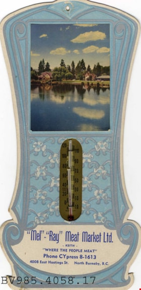
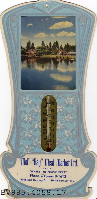
thermometer
https://search.heritageburnaby.ca/link/museumartifact12423
- Repository
- Burnaby Village Museum
- Accession Code
- BV985.4058.17
- Description
- "Mel-Ray" Meat Market - Thermometer. Promotional wall thermometer for "Mel-Ray" Meat Market with a glass thermometer and a cardboard backing. The thermometer has a picture of two cottages on a lake side. Below the thermometer is the name of the company, the phone number and the address which is "4008 East Hastings St. North Burnaby, B.C.". The thermometer is 14cm x 24cm.
Images
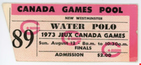
ticket
https://search.heritageburnaby.ca/link/museumartifact83921
- Repository
- Burnaby Village Museum
- Accession Code
- BV013.26.18
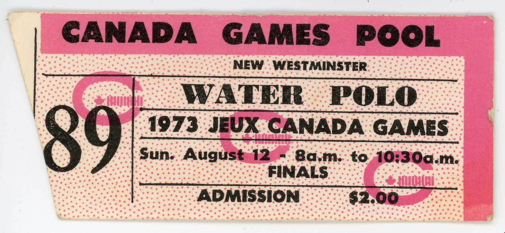
- Description
- Canada Games Pool - Ticket -- [1973]. Small white and pink ticket for the Jeux Canada Games Water Polo finals on Sunday August 12, 1973 at Canada Games Pool. The cost of admission was $2.00. The left side of the ticket is ripped. The reverse side of the ticket has the Royal Bank logo on it. The ticket measures 8.5cm x 3.5cm.
- Category
- 08. Communication Artifacts
- Classification
- Exchange Media
- Object Term
- Ticket
- Names
- Canada Summer Games
Images
ticket
https://search.heritageburnaby.ca/link/museumartifact83923
- Repository
- Burnaby Village Museum
- Accession Code
- BV013.26.20
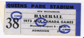
- Description
- Queens Park Stadium - Ticket -- [1973]. Small white and blue ticket for the Jeux Canada Games Baseball game on Monday August 6, 1973 at Queens Park Stadium. The cost of admission was $1.00. The left side of the ticket is ripped. The reverse side of the ticket has the Royal Bank logo on it. The ticket measures 8.5cm x 3.5cm.
- Category
- 08. Communication Artifacts
- Classification
- Exchange Media
- Object Term
- Ticket
- Names
- Canada Summer Games
Images

ticket
https://search.heritageburnaby.ca/link/museumartifact83925
- Repository
- Burnaby Village Museum
- Accession Code
- BV013.26.22
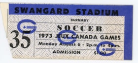
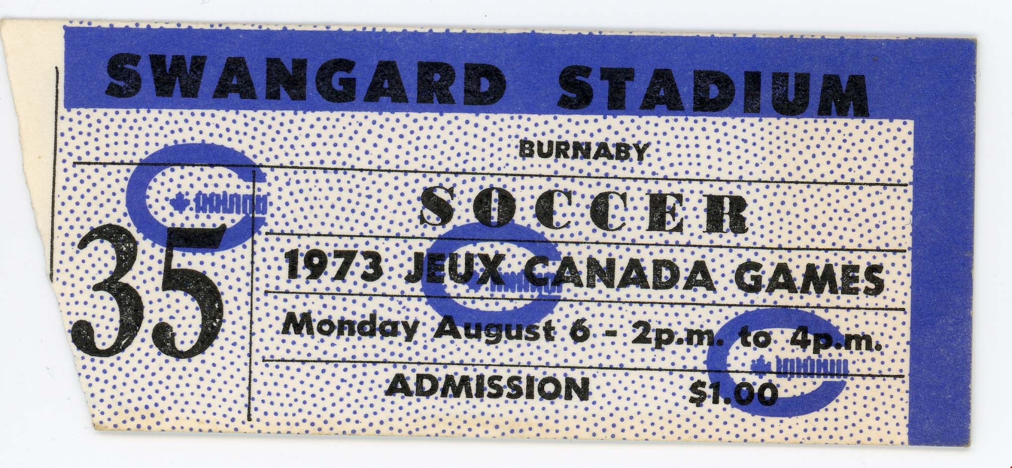
- Description
- Swangard Stadium - Ticket -- [1973]. Small white and blue ticket for the Jeux Canada Games Soccer game on Monday August 6, 1973 at Swangard Stadium. The cost of admission was $1.00. The left side of the ticket is ripped. The reverse side of the ticket has the Royal Bank logo on it. The ticket measures 8.5cm x 3.5cm.
- Category
- 08. Communication Artifacts
- Classification
- Exchange Media
- Object Term
- Ticket
- Names
- Canada Summer Games
Images
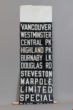
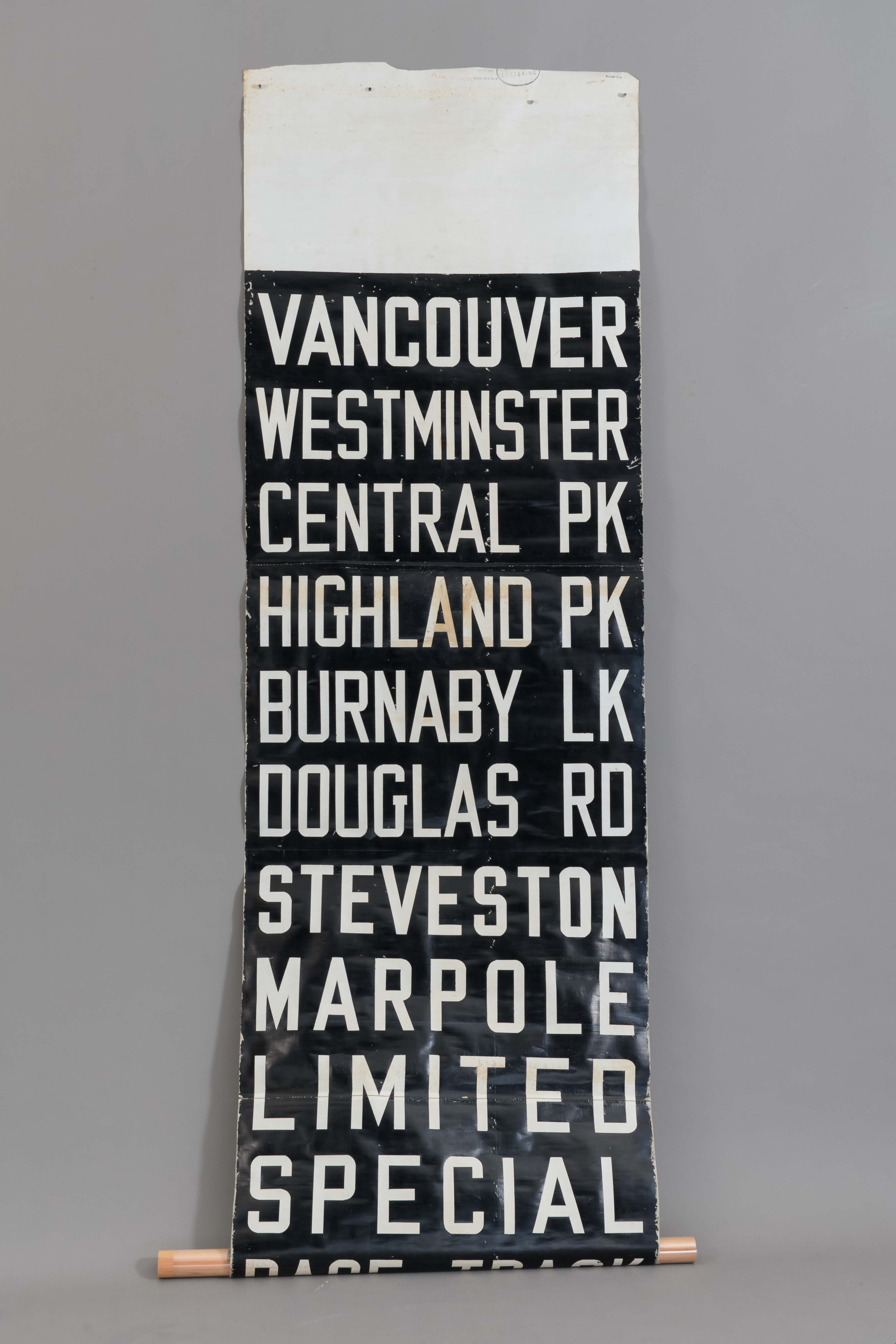
tram destination roller
https://search.heritageburnaby.ca/link/museumartifact48327
- Repository
- Burnaby Village Museum
- Accession Code
- BV005.17.6
- Description
- Fabric sign. For British Columbia Electric Railway. Destinations are in white lettering on black background. VANCOUVER WESTMINSTER CENTRAL PARK HIGHLAND PK BURNABY LAKE DOUGLAS RD STEVESTON MARPOLE LIMITED SPECIAL RACE TRACK There are handwritten abbreviations on reverse; printed on treated cotton fabric.
- Marks/Labels
- Vancouver / Westminster / Central Pk / Highland Pk / Burnaby Lk / Douglas Rd / Steveston / Marpole / Limited / Special / Race Track MAR 27 1950 / MADE IN U.S.A. / LETTERING ORDER No. 16936
- Country Made
- Canada
- Province Made
- British Columbia
- Site/City Made
- Vancouver
- Subjects
- Transportation
- Transportation - Public Transit
- Transportation - Electric Railroads
- Advertising Medium
- Advertising Medium - Signs and Signboards
Images
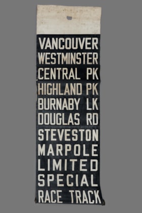
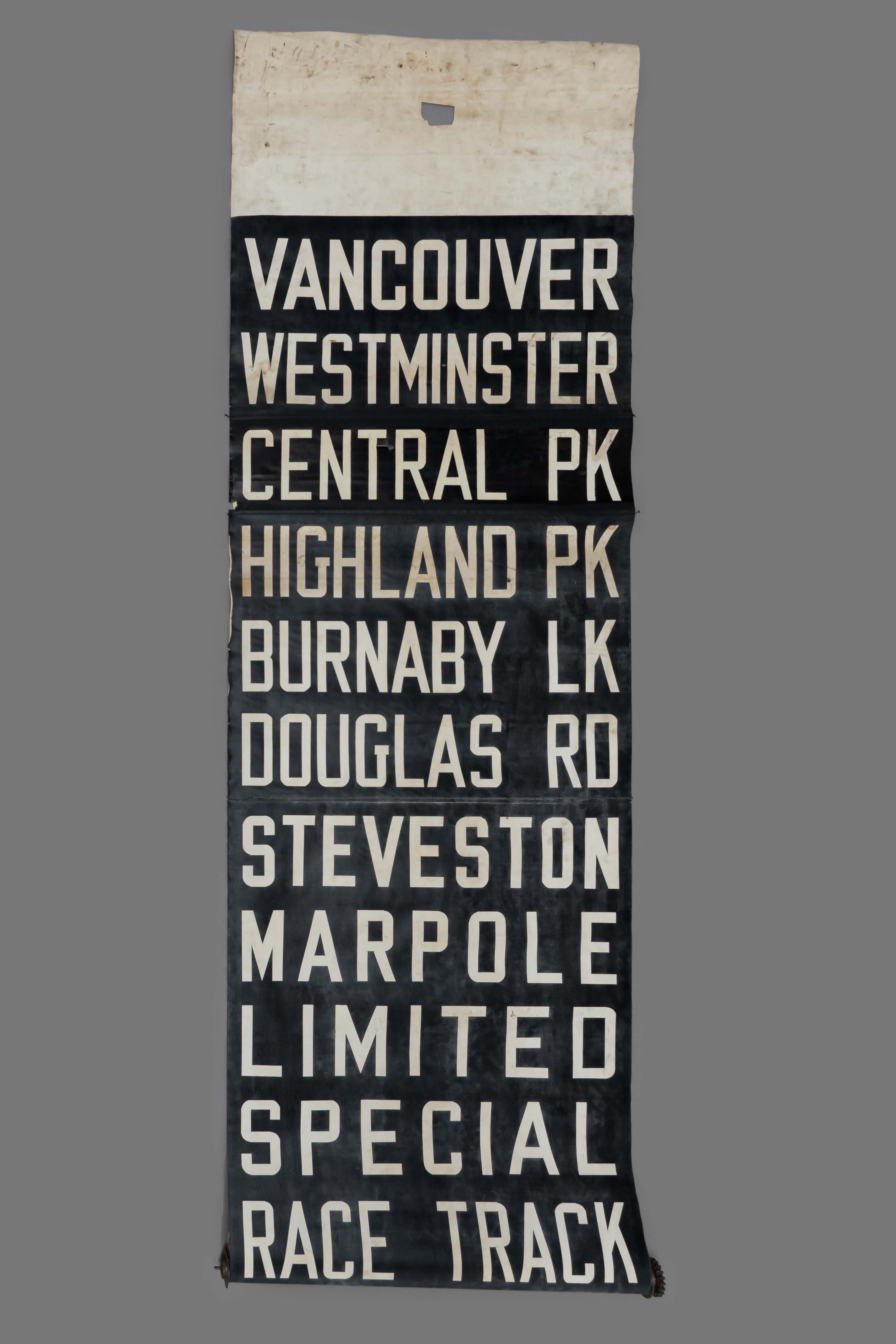
tram destination roller
https://search.heritageburnaby.ca/link/museumartifact25717
- Repository
- Burnaby Village Museum
- Accession Code
- HV975.73.3
- Description
- Stiff fabric scroll, rolled up and attached to a metal roll that would be placed into a holder. Black back ground and white capital letters for destinations: "VANCOUVER / WESTMINSTER / CENTRAL PK / HIGHLAND PK / BURNABY LK / DOUGLAS RD / STEVESTON / MARPOLE / LIMITED / SPECIAL / RACE TRACK / HORNE PAYNE / CARRALL ST / PARK AVE / CAR BARNS".
- Object History
- This was a destination roller for British Columbia Electric Railway tram, Burnaby Lake line. It was used by drivers to change the name of their destination.
- Classification
- Land Transportation T&E
- Object Term
- Sign
- Marks/Labels
- "CAR BARNS / CARRALL ST / PARK AVE / HORNE PAYNE / RACE TRACK / SPECIAL / LIMITED / MARPOLE / STEVESTON / DOUGLAS RD / BURNABY LK / HIGHLAND PK / CENTRAL PK / WESTMINSTER / VANCOUVER ". printed in white on black background. The back of the scroll has shortened versions of the destinations in black lettering on a white background.
- Subjects
- Transportation
- Transportation - Public Transit
- Transportation - Electric Railroads
- Advertising Medium
- Advertising Medium - Signs and Signboards
Images
![Trans Mountain Oil Pipe Line Co., [1958] thumbnail](/media/Hpo/_Data/_Archives_Images/_Unrestricted/001/097-001.jpg?width=280)
Trans Mountain Oil Pipe Line Co.
https://search.heritageburnaby.ca/link/archivedescription34688
- Repository
- City of Burnaby Archives
- Date
- [1958]
- Collection/Fonds
- Burnaby Historical Society fonds
- Description Level
- Item
- Physical Description
- 1 photograph : b&w ; 20.4 x 25.3 cm
- Scope and Content
- Aerial photograph of the Trans Mountain Oil Pipe Line Co. storage tanks on Burnaby Mountain.
- Repository
- City of Burnaby Archives
- Date
- [1958]
- Collection/Fonds
- Burnaby Historical Society fonds
- Subseries
- Photographs subseries
- Physical Description
- 1 photograph : b&w ; 20.4 x 25.3 cm
- Description Level
- Item
- Record No.
- 097-001
- Access Restriction
- No restrictions
- Reproduction Restriction
- Reproduce for fair dealing purposes only
- Accession Number
- BHS2007-04
- Scope and Content
- Aerial photograph of the Trans Mountain Oil Pipe Line Co. storage tanks on Burnaby Mountain.
- Media Type
- Photograph
- Photographer
- Commercial Illustrators Industrial Photographers
- Notes
- Title based on contents of photograph
- Stamp and annotation on back of photograph reads, "TA. 8817 / Commerical Illustrators / Industrial Photographers / 601 Denman St., Vancouver 5, B.C. / File No. 9412-13"
- Geographic Access
- Burnaby Mountain Conservation Area
- Shellmont Street
- Underhill Avenue
- Planning Study Area
- Lake City Area
Images
![Trans Mountain Oil Pipe Line Co., [1958] thumbnail](/media/Hpo/_Data/_Archives_Images/_Unrestricted/001/097-001.jpg)
![Trans Mountain Pipe Line loading dock, [1958] thumbnail](/media/Hpo/_Data/_Archives_Images/_Unrestricted/001/098-001.jpg?width=280)
Trans Mountain Pipe Line loading dock
https://search.heritageburnaby.ca/link/archivedescription34689
- Repository
- City of Burnaby Archives
- Date
- [1958]
- Collection/Fonds
- Burnaby Historical Society fonds
- Description Level
- Item
- Physical Description
- 1 photograph : b&w ; 20.4 x 25.3 cm
- Scope and Content
- Aerial photograph of the Trans Mountain Pipe Line Westridge loading dock on Burrard Inlet. Houses are visible in the background, and railroad tracks along the edge of the inlet.
- Repository
- City of Burnaby Archives
- Date
- [1958]
- Collection/Fonds
- Burnaby Historical Society fonds
- Subseries
- Photographs subseries
- Physical Description
- 1 photograph : b&w ; 20.4 x 25.3 cm
- Description Level
- Item
- Record No.
- 098-001
- Access Restriction
- No restrictions
- Reproduction Restriction
- Reproduce for fair dealing purposes only
- Accession Number
- BHS2007-04
- Scope and Content
- Aerial photograph of the Trans Mountain Pipe Line Westridge loading dock on Burrard Inlet. Houses are visible in the background, and railroad tracks along the edge of the inlet.
- Media Type
- Photograph
- Photographer
- Commercial Illustrators Industrial Photographers
- Notes
- Title based on contents of photograph
- Stamp and annotation on back of photograph reads, "TA. 8817 / Commerical Illustrators / Industrial Photographers / 601 Denman St., Vancouver 5, B.C. / File No. 9412-2"
- Historic Neighbourhood
- Lochdale (Historic Neighbourhood)
- Planning Study Area
- Westridge Area
Images
![Trans Mountain Pipe Line loading dock, [1958] thumbnail](/media/Hpo/_Data/_Archives_Images/_Unrestricted/001/098-001.jpg)

Vancouver, from Burnaby General Hospital
https://search.heritageburnaby.ca/link/archivedescription78865
- Repository
- City of Burnaby Archives
- Date
- October 14, 1976
- Collection/Fonds
- Burnaby Public Library Contemporary Visual Archive Project
- Description Level
- Item
- Physical Description
- 1 photograph : b&w ; 11 x 16 cm mounted on cardboard
- Scope and Content
- Photograph is an aerial view of Vancouver, looking west from the Burnaby General Hospital.
- Repository
- City of Burnaby Archives
- Date
- October 14, 1976
- Collection/Fonds
- Burnaby Public Library Contemporary Visual Archive Project
- Physical Description
- 1 photograph : b&w ; 11 x 16 cm mounted on cardboard
- Description Level
- Item
- Record No.
- 556-009
- Access Restriction
- No restrictions
- Reproduction Restriction
- Reproduce for fair dealing purposes only
- Accession Number
- 2013-13
- Scope and Content
- Photograph is an aerial view of Vancouver, looking west from the Burnaby General Hospital.
- Subjects
- Aerial Photographs
- Media Type
- Photograph
- Photographer
- Norton, Paul
- Notes
- Scope note taken directly from BPL photograph description.
- 1 b&w copy negative : 10 x 12.5 cm accompanying
Images


Vancouver, from Burnaby Heights
https://search.heritageburnaby.ca/link/archivedescription78862
- Repository
- City of Burnaby Archives
- Date
- October, 1976
- Collection/Fonds
- Burnaby Public Library Contemporary Visual Archive Project
- Description Level
- Item
- Physical Description
- 1 photograph : b&w ; 11 x 16 cm mounted on cardboard
- Scope and Content
- Photograph is an aerial view of Vancouver, looking west from the area of Parker Street and Gilmore Avenue with western Burnaby in the foreground.
- Repository
- City of Burnaby Archives
- Date
- October, 1976
- Collection/Fonds
- Burnaby Public Library Contemporary Visual Archive Project
- Physical Description
- 1 photograph : b&w ; 11 x 16 cm mounted on cardboard
- Description Level
- Item
- Record No.
- 556-008
- Access Restriction
- No restrictions
- Reproduction Restriction
- Reproduce for fair dealing purposes only
- Accession Number
- 2013-13
- Scope and Content
- Photograph is an aerial view of Vancouver, looking west from the area of Parker Street and Gilmore Avenue with western Burnaby in the foreground.
- Subjects
- Aerial Photographs
- Media Type
- Photograph
- Photographer
- Cook, Alan
- Notes
- Scope note taken directly from BPL photograph description.
- 1 b&w copy negative : 10 x 12.5 cm accompanying
- Geographic Access
- Parker Street
- Gilmore Avenue
- Historic Neighbourhood
- Vancouver Heights (Historic Neighbourhood)
- Planning Study Area
- Willingdon Heights Area
Images


Vantage Point Highrise
https://search.heritageburnaby.ca/link/archivedescription79942
- Repository
- City of Burnaby Archives
- Date
- October, 1976
- Collection/Fonds
- Burnaby Public Library Contemporary Visual Archive Project
- Description Level
- Item
- Physical Description
- 1 photograph : b&w ; 11 x 16 cm mounted on cardboard
- Scope and Content
- Photograph shows a view of Vantage Point Highrise at Lougheed Highway and Bellwood Avenue with Trans-Cold Refrigeration on Douglas Road in the foreground.
- Repository
- City of Burnaby Archives
- Date
- October, 1976
- Collection/Fonds
- Burnaby Public Library Contemporary Visual Archive Project
- Physical Description
- 1 photograph : b&w ; 11 x 16 cm mounted on cardboard
- Description Level
- Item
- Record No.
- 556-513
- Access Restriction
- No restrictions
- Reproduction Restriction
- Reproduce for fair dealing purposes only
- Accession Number
- 2013-13
- Scope and Content
- Photograph shows a view of Vantage Point Highrise at Lougheed Highway and Bellwood Avenue with Trans-Cold Refrigeration on Douglas Road in the foreground.
- Media Type
- Photograph
- Photographer
- Salmon, Stu
- Notes
- Scope note taken directly from BPL photograph description.
- 1 b&w copy negative : 10 x 12.5 cm accompanying
- Planning Study Area
- Dawson-Delta Area
Images

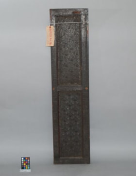
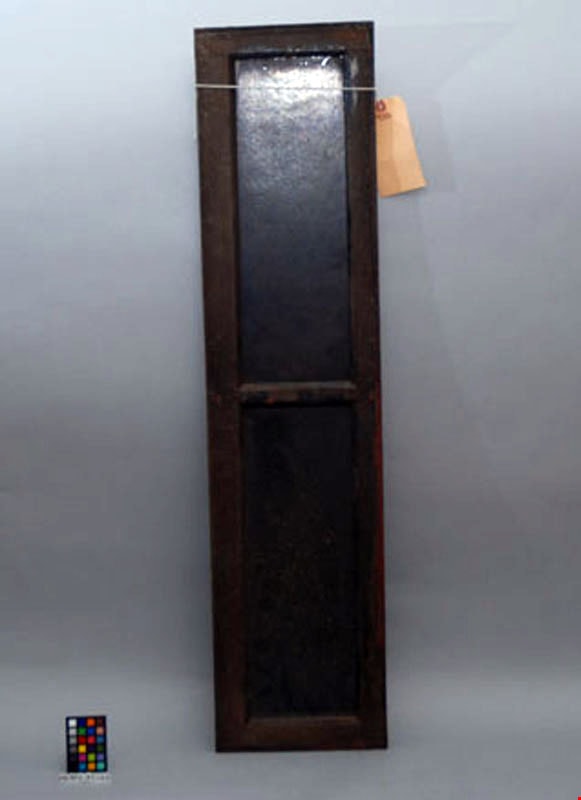
Window
https://search.heritageburnaby.ca/link/museumartifact29025
- Repository
- Burnaby Village Museum
- Accession Code
- HV973.41.101
- Description
- Wooden frame around two rectangular shaped windows with a wooden separation bar. The frame and windows are both dark (brown/black). The wooden frame appears to be composed of mahogony. The windows are composed of a glass-like material yet do not appear to be ordinary glass. One side of the windows has a scallop shell pattern and the other side is plain. Two holes are drilled through the edges of the frame at the midpoint. Length: 114 cm Width: 25 cm Thickness: 2.1 cm
- Object History
- British Columbia Electric Railway transom window.
- Marks/Labels
- Small blue sticker "BCER - B52".
- Subjects
- Transportation
- Transportation - Public Transit
- Transportation - Electric Railroads
- Advertising Medium
- Advertising Medium - Signs and Signboards
Images