Narrow Results By
Subject
- Accidents - Train Accidents 1
- Advertising Medium 3
- Advertising Medium - Business Cards 2
- Advertising Medium - Flyer 1
- Advertising Medium - Poster 1
- Advertising Medium - Signs and Signboards
- Aerial Photographs 11
- Agricultural Tools and Equipment - Plows 3
- Agriculture
- Agriculture - Dairy 2
- Agriculture - Farms 4
- Agriculture - Fruit and Berries 2
Person / Organization
- British Columbia Hydro and Power Authority 1
- Cosco, N. 1
- Dairyland 2
- Darlington Haskins Company 1
- Dunbar Hardwood Floor Limited 1
- E. Olsson and Sons Limited 1
- F. Fenk 1
- Fraser Valley Milk Producers Association 2
- Holmes and Wilson Trucking Company Limited 1
- L.J. McKinnon 1
- Marcovitch, J. 1
- Metrotown 1

Contractors
https://search.heritageburnaby.ca/link/archivedescription34150
- Repository
- City of Burnaby Archives
- Date
- April 20, 1947
- Collection/Fonds
- Burnaby Historical Society fonds
- Description Level
- Item
- Physical Description
- 1 photograph : b&w negative ; 6.8 x 11.4 cm
- Scope and Content
- Photograph of a sign indexing contractors and their phone numbers. The top of the sign reads: "Whitsell Construction Co. Ltd., General Contractors, Glen. 1434-1435." Others contractors listed are: Clearing and excavating: Holmes & Wilson, BA.0098; Concrete: J. Marcovitch; Brickwork: Selkirk Sadler…
- Repository
- City of Burnaby Archives
- Date
- April 20, 1947
- Collection/Fonds
- Burnaby Historical Society fonds
- Subseries
- Alfred Bingham subseries
- Physical Description
- 1 photograph : b&w negative ; 6.8 x 11.4 cm
- Description Level
- Item
- Record No.
- 010-067
- Access Restriction
- No restrictions
- Reproduction Restriction
- No known restrictions
- Accession Number
- BHS2007-04
- Scope and Content
- Photograph of a sign indexing contractors and their phone numbers. The top of the sign reads: "Whitsell Construction Co. Ltd., General Contractors, Glen. 1434-1435." Others contractors listed are: Clearing and excavating: Holmes & Wilson, BA.0098; Concrete: J. Marcovitch; Brickwork: Selkirk Sadler & Son, KE.1458; Electrical: L.J. McKinnon, PA.2471; Millwork: R.F. Tait Woodworkers, BA.6491; Painting: E. Olsson & Sons Ltd., GL.1434; Plumbing: F. Fenk, DE.3071; Plastering: Turner Bros., FA.2572-4982R; Roofing and strapping: Ray Shaw, FR.4720; Floors: Dunbar Hardwood Floor Ltd., KE.3646; Septic tanks: N. Cosco, BA.4987; Tiling: Darlington Haskins Co. 1943 Ltd., BA.4829. This is part of the Willingdon Heights subdivision site.
- Names
- Darlington Haskins Company
- Dunbar Hardwood Floor Limited
- E. Olsson and Sons Limited
- F. Fenk
- Holmes and Wilson Trucking Company Limited
- L.J. McKinnon
- Cosco, N.
- Ray Shaw
- R.F. Tait Woodworkers
- Selkirk Sadler and Son
- Turner Brothers
- Whitsell Construction Company Limited
- Marcovitch, J.
- Media Type
- Photograph
- Photographer
- Bingham, Alfred "Alf"
- Notes
- Title based on contents of photograph
Images


Construction Sign
https://search.heritageburnaby.ca/link/archivedescription79447
- Repository
- City of Burnaby Archives
- Date
- September 24, 1976
- Collection/Fonds
- Burnaby Public Library Contemporary Visual Archive Project
- Description Level
- Item
- Physical Description
- 1 photograph : b&w ; 11 x 16 cm mounted on cardboard
- Scope and Content
- Photograph shows an "obstruction ahead" sign put down by BC Hydro crew, who can be seen working in the background, near Sperling and Canada Way.
- Repository
- City of Burnaby Archives
- Date
- September 24, 1976
- Collection/Fonds
- Burnaby Public Library Contemporary Visual Archive Project
- Physical Description
- 1 photograph : b&w ; 11 x 16 cm mounted on cardboard
- Description Level
- Item
- Record No.
- 556-299
- Access Restriction
- No restrictions
- Reproduction Restriction
- Reproduce for fair dealing purposes only
- Accession Number
- 2013-13
- Scope and Content
- Photograph shows an "obstruction ahead" sign put down by BC Hydro crew, who can be seen working in the background, near Sperling and Canada Way.
- Media Type
- Photograph
- Photographer
- Born, A. J.
- Notes
- Scope note taken directly from BPL photograph description.
- 1 b&w copy negative : 10 x 12.5 cm accompanying
- Geographic Access
- Sperling Avenue
- Canada Way
- Historic Neighbourhood
- Burnaby Lake (Historic Neighbourhood)
- Planning Study Area
- Morley-Buckingham Area
Images


Quesnel Greene Construction
https://search.heritageburnaby.ca/link/archivedescription79014
- Repository
- City of Burnaby Archives
- Date
- October 23, 1976
- Collection/Fonds
- Burnaby Public Library Contemporary Visual Archive Project
- Description Level
- Item
- Physical Description
- 1 photograph : b&w ; 11 x 16 cm mounted on cardboard
- Scope and Content
- Photograph shows Quesnel Greene construction sign located at the corner of Aquarius Drive and Centaurus Circle. The Quesnel Green Co-operative Housing project was designed by Neinhaker/Irwin Associates and was built by Dunhill Development Corporation Ltd. It was owned by the Government of British…
- Repository
- City of Burnaby Archives
- Date
- October 23, 1976
- Collection/Fonds
- Burnaby Public Library Contemporary Visual Archive Project
- Physical Description
- 1 photograph : b&w ; 11 x 16 cm mounted on cardboard
- Description Level
- Item
- Record No.
- 556-091
- Access Restriction
- No restrictions
- Reproduction Restriction
- Reproduce for fair dealing purposes only
- Accession Number
- 2013-13
- Scope and Content
- Photograph shows Quesnel Greene construction sign located at the corner of Aquarius Drive and Centaurus Circle. The Quesnel Green Co-operative Housing project was designed by Neinhaker/Irwin Associates and was built by Dunhill Development Corporation Ltd. It was owned by the Government of British Columbia.
- Media Type
- Photograph
- Photographer
- Campbell, Peg
- Notes
- Scope note taken directly from BPL photograph description.
- 1 b&w copy negative : 10 x 12.5 cm accompanying
- Geographic Access
- Centaurus Circle
- Aquarius Drive
- Historic Neighbourhood
- Burquitlam (Historic Neighbourhood)
- Planning Study Area
- Lyndhurst Area
Images

![Dismantling the Eaton Centre sign, [2000] thumbnail](/media/hpo/_Data/_Archives_Images/_Unrestricted/535/535-2901.jpg?width=280)
Dismantling the Eaton Centre sign
https://search.heritageburnaby.ca/link/archivedescription97562
- Repository
- City of Burnaby Archives
- Date
- [2000]
- Collection/Fonds
- Burnaby NewsLeader photograph collection
- Description Level
- Item
- Physical Description
- 1 photograph (tiff) : col.
- Scope and Content
- Photograph of a construction worker dismantling the Eaton Centre sign at the new Metropolis at Metrotown mall.
- Repository
- City of Burnaby Archives
- Date
- [2000]
- Collection/Fonds
- Burnaby NewsLeader photograph collection
- Physical Description
- 1 photograph (tiff) : col.
- Description Level
- Item
- Record No.
- 535-2901
- Access Restriction
- No restrictions
- Reproduction Restriction
- No restrictions
- Accession Number
- 2018-12
- Scope and Content
- Photograph of a construction worker dismantling the Eaton Centre sign at the new Metropolis at Metrotown mall.
- Names
- Metrotown
- Media Type
- Photograph
- Photographer
- Bartel, Mario
- Notes
- Title based on caption
- Collected by editorial for use in an October 2000 issue of the Burnaby NewsLeader
- Caption from metadata: "Workers dismantle the Eaton Centre sign as the mall at Metrotown begins its new life as Metropolis at Metrotown."
- Geographic Access
- Kingsway
- Street Address
- 4700 Kingsway
- Historic Neighbourhood
- Central Park (Historic Neighbourhood)
- Planning Study Area
- Maywood Area
Images
![Dismantling the Eaton Centre sign, [2000] thumbnail](/media/hpo/_Data/_Archives_Images/_Unrestricted/535/535-2901.jpg)

New regulations at work site
https://search.heritageburnaby.ca/link/archivedescription95095
- Repository
- City of Burnaby Archives
- Date
- April 16, 2020
- Collection/Fonds
- Burnaby Photographic Society fonds
- Description Level
- Item
- Physical Description
- 1 photograph (tiff)
- Scope and Content
- Photograph of signs attached to security fencing outside the closed Schou Education Centre on Canada Way. Signs are handwritten and contain COVID-19 site safety protocols. Photograph was taken from Norfolk Street, facing south.
- Repository
- City of Burnaby Archives
- Date
- April 16, 2020
- Collection/Fonds
- Burnaby Photographic Society fonds
- Physical Description
- 1 photograph (tiff)
- Description Level
- Item
- Record No.
- 623-014
- Access Restriction
- No restrictions
- Reproduction Restriction
- No restrictions
- Accession Number
- 2020-10
- Scope and Content
- Photograph of signs attached to security fencing outside the closed Schou Education Centre on Canada Way. Signs are handwritten and contain COVID-19 site safety protocols. Photograph was taken from Norfolk Street, facing south.
- Media Type
- Photograph
- Photographer
- Damer, Eric
- Notes
- Transcribed title
- Geographic Access
- Gilmore Avenue
- Canada Way
- Street Address
- 4054 Norfolk Street
- Historic Neighbourhood
- Broadview (Historic Neighbourhood)
- Planning Study Area
- Cascade-Schou Area
Images


date plaque
https://search.heritageburnaby.ca/link/museumartifact90987
- Repository
- Burnaby Village Museum
- Accession Code
- BV021.11.1
- Description
- Bronze date plaque stamped "F.V.M.P.A./ BURNABY PLANT SOD TURNING / JULY 26, 1962" with 4 corner holes. The object has scratches throughout. The plaque is taped to a cardboard tag with the text "B5102 / $0.80"
- Object History
- The plate is to commemorate the Fraser Valley Milk Producers Assocation Burnaby Plant sod turning ceremony on July 26, 1962, when construction started on the new facility at Sperling and Lougheed. The plant opened in 1964, and housed the FVMPA head offices, fluid milk plant, and ice cream manufacturing division.
- Category
- 08. Communication Artifacts
- Classification
- Documentary Artifacts - - Other Documents
- Object Term
- Plate, Identification
- Measurements
- 6.3cm wide x 3.1cm high
- Subjects
- Foods
- Agriculture
- Agriculture - Dairy
- Historic Neighbourhood
- Lozells (Historic Neighbourhood)
- Planning Study Area
- Government Road Area
Images


Martello Group sign at 6615 Telford Avenue
https://search.heritageburnaby.ca/link/archivedescription98675
- Repository
- City of Burnaby Archives
- Date
- 2022
- Collection/Fonds
- Disappearing Burnaby collection
- Description Level
- Item
- Physical Description
- 1 photograph (jpeg) : col.
- Scope and Content
- Photograph of a sign, which reads "Professionally Managed by Martello," on the lawn of an apartment building located at 6615 Telford Avenue. The building was constructed in 1964. Other residential towers, a construction crane, and cars parked along Telford Avenue are visible in the background.
- Repository
- City of Burnaby Archives
- Date
- 2022
- Collection/Fonds
- Disappearing Burnaby collection
- Physical Description
- 1 photograph (jpeg) : col.
- Description Level
- Item
- Record No.
- 634-022
- Access Restriction
- No restrictions
- Reproduction Restriction
- No restrictions
- Accession Number
- 2022-14
- Scope and Content
- Photograph of a sign, which reads "Professionally Managed by Martello," on the lawn of an apartment building located at 6615 Telford Avenue. The building was constructed in 1964. Other residential towers, a construction crane, and cars parked along Telford Avenue are visible in the background.
- Subjects
- Buildings - Residential
- Buildings - Residential - Apartments
- Advertising Medium - Signs and Signboards
- Media Type
- Photograph
- Photographer
- Cheung, Nakita
- Notes
- Title taken from the associated blog post
- Associated blog post: https://disappearingburnaby.wordpress.com/2022/06/09/martello-group/
- Geographic Access
- Telford Avenue
- Street Address
- 6615 Telford Avenue
- Historic Neighbourhood
- Central Park (Historic Neighbourhood)
- Planning Study Area
- Maywood Area
Images


Rooted : Chinese Canadian stories in Burnaby
https://search.heritageburnaby.ca/link/museumlibrary7646
- Repository
- Burnaby Village Museum
- Collection
- Digital Reference Collection
- Material Type
- Digital Resource
- ISBN
- 978-0-9689849-2-5
- Call Number
- 971.133 ROO
- Contributor
- Fong, Denise
- Lemke, Jane
- Codd, Lisa
- Place of Publication
- Burnaby
- Publisher
- City of Burnaby
- Publication Date
- 2023
- Printer
- Metropolitan Fine Printers
- Physical Description
- 203 p. : ill. ; 30.5 cm
- Library Subject (LOC)
- Chinese Canadians--British Columbia--Burnaby--History
- Race discrimination -- Canada
- Subjects
- Persons - Chinese Canadians
- Agriculture
- Agriculture - Farms
- Persons - Families
- Rights
- Rights - Human Rights
- Social Issues
- Social Issues - Racism
- Notes
- There are two versions of the book: English and Simplified Chinese (left, below) and the other in English and Traditional Chinese (right, below).
- From the late 1800s to the present day, Chinese Canadians have made Burnaby into a more vibrant and livable city. Rooted: Chinese Canadian Stories in Burnaby brings together a collection of diverse stories and photographs from the community, celebrating the legacy and contributions of Burnaby’s Chinese Canadian community spanning over a century. This coffee-table book features oral histories and interviews with descendants of multigenerational family farms, green grocers, corner stores, restaurants, and places of worship. Also included are archival research and community perspectives on anti-Asian racism, community activism, courage, and resilience.
- The publication has been timed to coincide with the 100th anniversary of the introduction of the Chinese Exclusion Act by the Government of Canada in 1923. This federal legislation followed decades of discriminatory legislation by Canada’s federal, provincial and municipal governments that targeted Chinese Canadians by limiting opportunities to live, work and raise families in Canada. The Chinese Exclusion Act banned almost all migration from China and remained in place until 1947. Publishing this book in 2023 is an effort by the City of Burnaby to recognize the impact of discriminatory legislation on Chinese Canadians in our community, including discriminatory bylaws and practices implemented by Burnaby’s early municipal government.
- Edited by Denise Fong (Lead Researcher), Jane Lemke (Burnaby Village Museum Curator) and Lisa Codd (City of Burnaby Heritage Planner).
Images

Digital Books
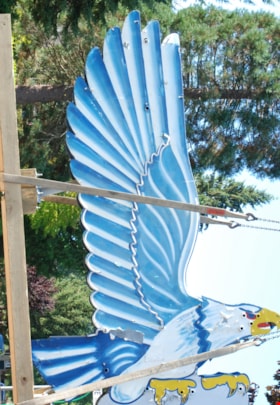
neon sign
https://search.heritageburnaby.ca/link/museumartifact86079
- Repository
- Burnaby Village Museum
- Accession Code
- BV016.18.2
- Description
- Eagle Ford neon sign. It is a large double-sided hollow sheet metal sign measuring 13.3 feet tall and 8.9 feet wide. The sheet metal and structure of the sign retains most of the eagle's original painted image, including the dramatic wings with their blue and white feather pattern.
- Object History
- Eagle Motors Limited was established by the well-known Burnaby businessman Frank McCracken at 4161 Hastings Street in 1948. The car dealership became a successful local Heights business and was the largest Ford car and truck retailer in the province during its operation. The company had adopted the silhouette of the classic Bald Eagle in full flight to serve as a logo which was utilized in advertising and promotional materials. The eagle symbol was famously developed into a classic chrome badge with the name "Eagle Ford - Burnaby, BC" that was installed on all the Eagle Ford cars and trucks sold by the dealership. After a new showroom building was constructed on the site in 1950, the company commissioned Neon Products of Vancouver to manufacture a very large double-sided neon eagle. Typical of neon signs of the era, the eagle was painted with dramatic designs and bright primary colours on metal with blue, white, and gold neon tubing serving to highlight the outline of the eagle.
- The "Burnaby Eagle" sign immediately became a landmark on the Burnaby Heights business district. From its high perch atop the dealership building, located at Carleton Street, the Burnaby Eagle shared the night sky with other nearby classic neon signs of the era including the "Swinging Girl" sign of the Helen's Children's Wear store. Eagle Motors was a successful dealership until the recession of the 1980s, and in 1985 the business was closed. Vandalism on the site resulted in damage to the neon tubing of the sign before the leased sign was reclaimed by its owner, Neon Products Limited. The sign was obtained by a local collector, who carefully looked after it for 25 years. In 2012, the sign was sold to the City of Burnaby.
- The sign will be restored and installed near its original location on Hastings Street in 2024.
- Reference
- Community Heritage Commission report to Council, September 17, 2012.
- Measurements
- Height: 14 ft. Width: 9 ft. Thickness: 14 in.
- Historic Neighbourhood
- Vancouver Heights (Historic Neighbourhood)
- Planning Study Area
- Burnaby Heights Area
Images

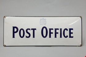
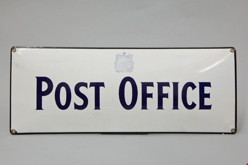
post office sign
https://search.heritageburnaby.ca/link/museumartifact82360
- Repository
- Burnaby Village Museum
- Accession Code
- BV012.14.92
- Description
- white enamel sign with blue "POST OFFICE" lettering and emblem, black trim with holes for affixing sign, measures 19.5 cm h. x 48.5 cm l. Reverse is also white and the sign appears to have been hand-dipped in enamel as there are hand finger-marks on reverse.
- Object History
- Annie D. Basiuk (later Yanko) was born on February 25, 1902 in Sheho, Saskatchewan (formerly Sheho, North West Territories). Daniel "Dan" Yanko was born in Kobilnicha, Ukraine in 1887 and immigrated to Canada in May or June of 1905. Daniel Yanko married Annie D. Basiuk and had thirteen children together. Their son, John Ivan Yanko was born on the family farm, near Kelliher, Saskatchewan, on June 27, 1923. In grade six, John was pulled out of school to help support the family. Eugenia “Jenny” Haresomovych (later Carman) was born August 8, 1904 in Galecia, Austria. She came to Canada in 1928, when her parents sent her to live with the Austrian consular in Halifax. A year later, she was in The Pas with Albert Edward Carman, with whom she would have three children. Their daughter, Leida Doria "Lillian Doris" Carman was born in The Pas, Manitoba March 24, 1929. Eugenia “Jenny” (Haresomovych) Carman later re-married Joseph Nagy who was born in Hungary in October 3, 1900. Jenny, Joseph and the children moved to Nelson, British Columbia, where Joseph worked for the Canadian Pacific Railway. At the age of twenty, John Yanko met his future wife Lillian Doris Carman while visiting relatives in Burnaby. Lillian received a rail pass because of her dad’s employment with the CPR and at fourteen had gone to visit her Godmother in Burnaby. John Ivan Yanko and Leida Doria "Lillian Doris" Carman were married October 16, 1948 in Nelson, British Columbia and moved into the basement of John’s sister’s house on Union Street. Lillian began working at the downtown Woodward’s store as a cashier in 1948. In 1950, the young couple bought property at 7385 (later renumbered 7391) Broadway in Burnaby and began constructing a house as they could afford it. Knowing she’d be let go if she was pregnant, when Lillian was expecting her first child, Jenny sewed her several versions of the same outfit; they all used the same material, but each was a little bit larger than the last to accommodate her expanding girth. Rhonda, born in 1953 and Charmaine, born in 1955, grew up in the Broadway home. They attended school at Sperling Elementary, and later at Burnaby North high school. Lillian left her job to be a stay-at-home mom when Rhonda was born, but that changed in 1963 when John and Charmaine were in a car accident that left John temporarily unable to work. Joseph Nagy died April 20, 1962; his wife Eugenia “Jenny” (Haresomovych) (Carman) Nagy passed away August 14, 1985. Daniel "Dan" Yanko died in 1976; his wife Annie D. (Basiuk) Yanko died in 1997. John Yanko later returned to work, establishing his own tile setting business and working until age eighty-two. John and Lillian lived out the rest of their married lives on the Broadway property. John Ivan Yanko passed away in 2010; his wife Leida Doria "Lillian Doris" Carman (Carman) Yanko passed away in 2011.
- Names
- Yanko Family
Images

Star Light Apartments sign
https://search.heritageburnaby.ca/link/archivedescription98677
- Repository
- City of Burnaby Archives
- Date
- 2022
- Collection/Fonds
- Disappearing Burnaby collection
- Description Level
- Item
- Physical Description
- 1 photograph (jpeg) : col.
- Scope and Content
- Photograph of the Blue Sky Investments Ltd.'s sign on the lawn of Star Light Apartments, a low-rise apartment building located at 6555 Telford Avenue. The building was constructed in 1964. The photograph depicts the scene at dusk; the building's entrance is visible to the left, with its exterior li…
- Repository
- City of Burnaby Archives
- Date
- 2022
- Collection/Fonds
- Disappearing Burnaby collection
- Physical Description
- 1 photograph (jpeg) : col.
- Description Level
- Item
- Record No.
- 634-024
- Access Restriction
- No restrictions
- Reproduction Restriction
- No restrictions
- Accession Number
- 2022-14
- Scope and Content
- Photograph of the Blue Sky Investments Ltd.'s sign on the lawn of Star Light Apartments, a low-rise apartment building located at 6555 Telford Avenue. The building was constructed in 1964. The photograph depicts the scene at dusk; the building's entrance is visible to the left, with its exterior lights on, and Telford Avenue and other neighbouring towers are visible in the background.
- Subjects
- Buildings - Residential
- Buildings - Residential - Apartments
- Advertising Medium - Signs and Signboards
- Media Type
- Photograph
- Photographer
- Cheung, Nakita
- Notes
- Title taken from the associated blog post
- Associated blog post: https://disappearingburnaby.wordpress.com/2022/06/24/star-light-apartments/
- Geographic Access
- Telford Avenue
- Street Address
- 6555 Telford Avenue
- Historic Neighbourhood
- Central Park (Historic Neighbourhood)
- Planning Study Area
- Marlborough Area
Images


Sussex Villa
https://search.heritageburnaby.ca/link/archivedescription98659
- Repository
- City of Burnaby Archives
- Date
- 2022
- Collection/Fonds
- Disappearing Burnaby collection
- Description Level
- Item
- Physical Description
- 1 photograph (jpeg) : col.
- Scope and Content
- Photograph of part of the exterior and front lawn of Sussex Villa, an apartment complex located at 6620-6630 Sussex Avenue, at night. The building was constructed in 1965 and is set to be developed into a high-rise tower by Keltic Canada Development. A light is on inside one of the apartment window…
- Repository
- City of Burnaby Archives
- Date
- 2022
- Collection/Fonds
- Disappearing Burnaby collection
- Physical Description
- 1 photograph (jpeg) : col.
- Description Level
- Item
- Record No.
- 634-006
- Access Restriction
- No restrictions
- Reproduction Restriction
- No restrictions
- Accession Number
- 2022-14
- Scope and Content
- Photograph of part of the exterior and front lawn of Sussex Villa, an apartment complex located at 6620-6630 Sussex Avenue, at night. The building was constructed in 1965 and is set to be developed into a high-rise tower by Keltic Canada Development. A light is on inside one of the apartment windows and a sign for the "Metrotown - Regional Town Centre Notification of Area Plan" stands on the lawn.
- Subjects
- Buildings - Residential - Apartments
- Buildings - Residential
- Advertising Medium - Signs and Signboards
- Planning - City Planning
- Media Type
- Photograph
- Photographer
- Cheung, Nakita
- Notes
- Title taken from the associated blog post
- Associated blog post: https://disappearingburnaby.wordpress.com/2022/01/29/sussex-villa-2/
- Geographic Access
- Sussex Avenue
- Street Address
- 6620 Sussex Avenue
- 6630 Sussex Avenue
- Historic Neighbourhood
- Central Park (Historic Neighbourhood)
- Planning Study Area
- Maywood Area
Images


Sussex Villa with sign
https://search.heritageburnaby.ca/link/archivedescription98660
- Repository
- City of Burnaby Archives
- Date
- 2022
- Collection/Fonds
- Disappearing Burnaby collection
- Description Level
- Item
- Physical Description
- 1 photograph (jpeg) : col.
- Scope and Content
- Photograph of part of the exterior and front lawn of Sussex Villa, an apartment complex located at 6620-6630 Sussex Avenue, at night. The building was constructed in 1965 and is set to be developed into a high-rise tower by Keltic Canada Development. A sign standing on the lawn reads: "Land Loan" a…
- Repository
- City of Burnaby Archives
- Date
- 2022
- Collection/Fonds
- Disappearing Burnaby collection
- Physical Description
- 1 photograph (jpeg) : col.
- Description Level
- Item
- Record No.
- 634-007
- Access Restriction
- No restrictions
- Reproduction Restriction
- No restrictions
- Accession Number
- 2022-14
- Scope and Content
- Photograph of part of the exterior and front lawn of Sussex Villa, an apartment complex located at 6620-6630 Sussex Avenue, at night. The building was constructed in 1965 and is set to be developed into a high-rise tower by Keltic Canada Development. A sign standing on the lawn reads: "Land Loan" and "Domain Funding" with contact information, and a residential tower is visible in the background.
- Subjects
- Buildings - Residential - Apartments
- Buildings - Residential
- Advertising Medium - Signs and Signboards
- Media Type
- Photograph
- Photographer
- Cheung, Nakita
- Notes
- Title taken from the associated blog post
- Associated blog post: https://disappearingburnaby.wordpress.com/2022/01/29/sussex-villa-2/
- Geographic Access
- Sussex Avenue
- Street Address
- 6620 Sussex Avenue
- 6630 Sussex Avenue
- Historic Neighbourhood
- Central Park (Historic Neighbourhood)
- Planning Study Area
- Maywood Area
Images

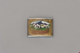
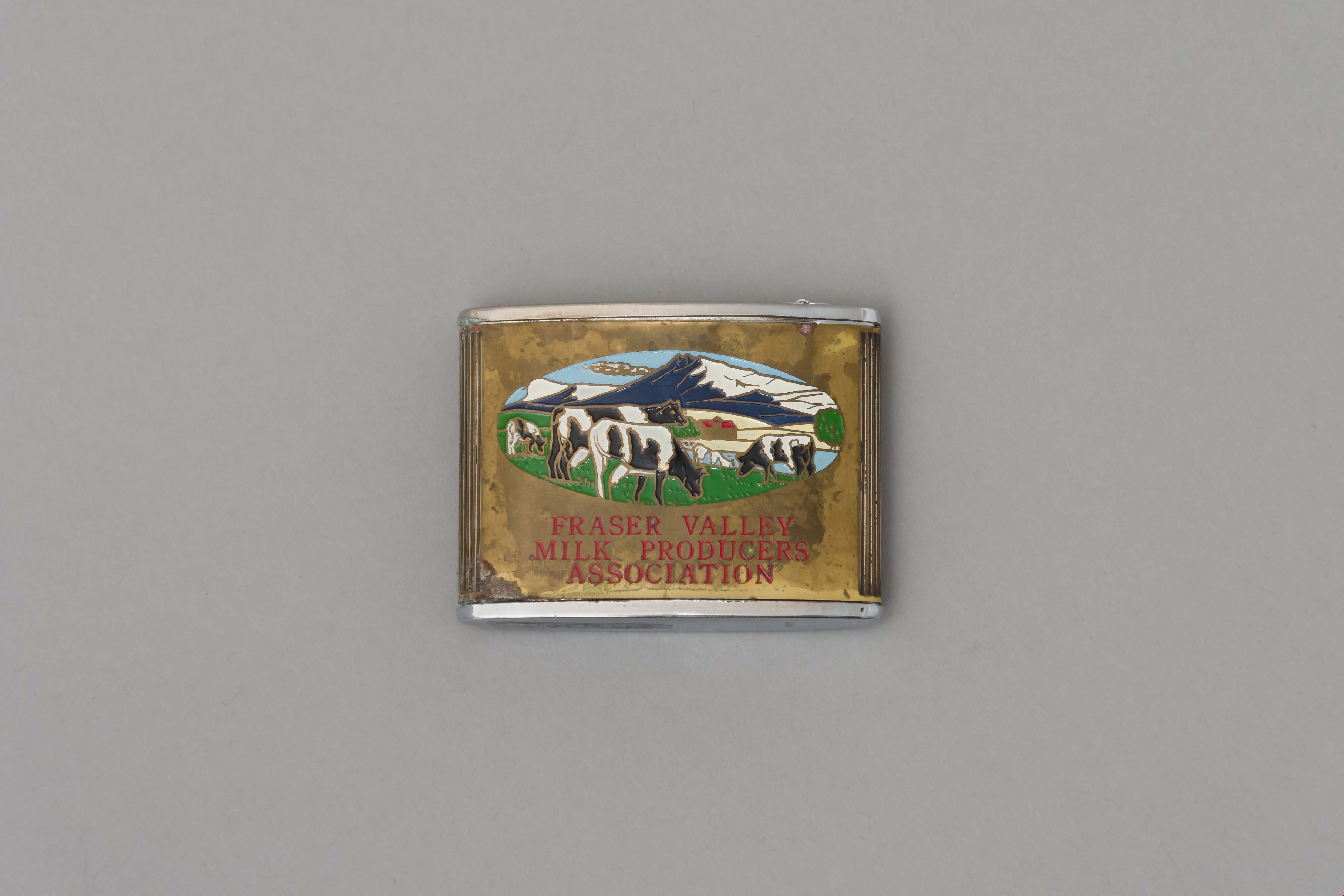
tape measure
https://search.heritageburnaby.ca/link/museumartifact90960
- Repository
- Burnaby Village Museum
- Accession Code
- BV021.10.1
- Description
- Promitional tape measurer with a silver top plates and a gold body engraved on both sides. One side dark blue with ariel drawing of building and "Dairyland/ BURNABY PLANT/ 1964" engraved. Reverse is oval image of 4 cows in a field with mountains, sky, and a barn painted on a gold body with "FRASER VALLEY/ MILK PRODUCERS/ ASSOCIATION" in red. Top has a retractable silver steel tape with measurements in inches on one side. "Japan" engraved on base.
- Object History
- This object belonged to a sales representative for Dairyland, who lived in Chilliwack. He retired in 1978 after 40 years with the company. The Burnaby Dairyland plant was constructed in 1964 on Lougheed Highway near Sperling Avenue.
- Reference
- http://www.bcdairyhistory.ca/milk-break/magazine/1964-fraser-valley-milk-break.pdf
- Classification
- Weights and Measurements Tools and Equipment - Scales
- Object Term
- Retractable Rule, Tape Measure
- Marks/Labels
- "Dairyland Burnaby Plant 1964", "Fraser Valley Milk Producers Association" "Japan"
- Measurements
- 4cm high x 5cm wide
- Subjects
- Foods
- Agriculture
- Agriculture - Dairy
- Historic Neighbourhood
- Lozells (Historic Neighbourhood)
- Planning Study Area
- Government Road Area
Images