Narrow Results By
Certificate of Sufficiency - Lane West of Curragh Avenue between Arbroath Street and the Northerly Property Line of Lot 12 DL 92 Plan 15512 (5991 Arbroath Street)
https://search.heritageburnaby.ca/link/councilreport14457
- Repository
- City of Burnaby Archives
- Report ID
- 11606
- Meeting Date
- 5-Oct-1987
- Format
- Council - Mayor/Councillor/Staff Report
- Collection/Fonds
- City Council and Office of the City Clerk fonds
- Repository
- City of Burnaby Archives
- Report ID
- 11606
- Meeting Date
- 5-Oct-1987
- Format
- Council - Mayor/Councillor/Staff Report
- Collection/Fonds
- City Council and Office of the City Clerk fonds
Documents
Cost Report - Construction and Paving of Lane West of Curragh Avenue between Arbroath Street and the Northerly Property Line of Lot 12 DL 91 Plan 15512 (5991 Arbroath Street)
https://search.heritageburnaby.ca/link/councilreport14423
- Repository
- City of Burnaby Archives
- Report ID
- 11652
- Meeting Date
- 26-Oct-1987
- Format
- Council - Manager's Report
- Manager's Report No.
- 65
- Item No.
- 9
- Collection/Fonds
- City Council and Office of the City Clerk fonds
- Repository
- City of Burnaby Archives
- Report ID
- 11652
- Meeting Date
- 26-Oct-1987
- Format
- Council - Manager's Report
- Manager's Report No.
- 65
- Item No.
- 9
- Collection/Fonds
- City Council and Office of the City Clerk fonds
Documents
Certificate of Sufficiency Covering Paving of Arbroath Street
https://search.heritageburnaby.ca/link/councilreport42556
- Repository
- City of Burnaby Archives
- Report ID
- 40746
- Meeting Date
- 2-Dec-1957
- Format
- Council - Mayor/Councillor/Staff Report
- Collection/Fonds
- City Council and Office of the City Clerk fonds
- Repository
- City of Burnaby Archives
- Report ID
- 40746
- Meeting Date
- 2-Dec-1957
- Format
- Council - Mayor/Councillor/Staff Report
- Collection/Fonds
- City Council and Office of the City Clerk fonds
Documents
Inspections of Property at 6360 Arbroath Street, Parcel "A" DL 96 Plan 54405 (Jubilee Estates and Lands Limited)
https://search.heritageburnaby.ca/link/councilreport21702
- Repository
- City of Burnaby Archives
- Report ID
- 15185
- Meeting Date
- 11-Sep-1978
- Format
- Council - Manager's Report
- Manager's Report No.
- 62
- Item No.
- 12
- Collection/Fonds
- City Council and Office of the City Clerk fonds
- Repository
- City of Burnaby Archives
- Report ID
- 15185
- Meeting Date
- 11-Sep-1978
- Format
- Council - Manager's Report
- Manager's Report No.
- 62
- Item No.
- 12
- Collection/Fonds
- City Council and Office of the City Clerk fonds
Documents
Request for Demolition of House at 6450 Arbroath Street Edmonds Town Centre West
https://search.heritageburnaby.ca/link/councilreport9831
- Repository
- City of Burnaby Archives
- Report ID
- 5600
- Meeting Date
- 22-Feb-1993
- Format
- Council - Manager's Report
- Manager's Report No.
- 13
- Item No.
- 6
- Collection/Fonds
- City Council and Office of the City Clerk fonds
- Repository
- City of Burnaby Archives
- Report ID
- 5600
- Meeting Date
- 22-Feb-1993
- Format
- Council - Manager's Report
- Manager's Report No.
- 13
- Item No.
- 6
- Collection/Fonds
- City Council and Office of the City Clerk fonds
Documents
Request for Permission to Demolish Buildings 6450, 6455, 6469, 6470, 6489 Arbroath Street, 6686 and 6694 Kingsway Edmonds Town Centre West
https://search.heritageburnaby.ca/link/councilreport10112
- Repository
- City of Burnaby Archives
- Report ID
- 4064
- Meeting Date
- 13-Oct-1992
- Format
- Council - Manager's Report
- Manager's Report No.
- 64
- Item No.
- 6
- Collection/Fonds
- City Council and Office of the City Clerk fonds
- Repository
- City of Burnaby Archives
- Report ID
- 4064
- Meeting Date
- 13-Oct-1992
- Format
- Council - Manager's Report
- Manager's Report No.
- 64
- Item No.
- 6
- Collection/Fonds
- City Council and Office of the City Clerk fonds
Documents
Request for Temporary Closure of Conway Avenue and Arbroath Street on 1986 September 28 for Marshalling Area for Wheel-a-thon
https://search.heritageburnaby.ca/link/councilreport15308
- Repository
- City of Burnaby Archives
- Report ID
- 10748
- Meeting Date
- 22-Sep-1986
- Format
- Council - Manager's Report
- Manager's Report No.
- 55
- Item No.
- 3
- Collection/Fonds
- City Council and Office of the City Clerk fonds
- Repository
- City of Burnaby Archives
- Report ID
- 10748
- Meeting Date
- 22-Sep-1986
- Format
- Council - Manager's Report
- Manager's Report No.
- 55
- Item No.
- 3
- Collection/Fonds
- City Council and Office of the City Clerk fonds
Documents

'The Gables'
https://search.heritageburnaby.ca/link/landmark516
- Repository
- Burnaby Heritage Planning
- Description
- 'The Gables' is a one and one-half storey plus basement residence with a distinctive cross-gambrel roof. The foundations and first storey facade are constructed of granite rubble-stone with raised pointing, and the remainder of the house is clad in cedar shingles. It is now part of the Tudor Grove …
- Associated Dates
- 1920
- Formal Recognition
- Heritage Designation, Community Heritage Register
- Other Names
- John & Christina Mackie House
- Street View URL
- Google Maps Street View
- Repository
- Burnaby Heritage Planning
- Other Names
- John & Christina Mackie House
- Geographic Access
- Arbroath Street
- Southoaks Crescent
- Associated Dates
- 1920
- Formal Recognition
- Heritage Designation, Community Heritage Register
- Enactment Type
- Bylaw No. 10314
- Enactment Date
- 15/01/1996
- Description
- 'The Gables' is a one and one-half storey plus basement residence with a distinctive cross-gambrel roof. The foundations and first storey facade are constructed of granite rubble-stone with raised pointing, and the remainder of the house is clad in cedar shingles. It is now part of the Tudor Grove residential complex.
- Heritage Value
- The residence is valued as the house of John Mackie (1879-1937) and Christina Mackie (1881-1959) and is significant as the last house remaining from the original Highland Park subdivision. The area was first laid out in 1902, and then remarketed by C.L. Merritt and Company in 1911 as 'Gilley Park - the Suburb Beautiful.' Located on the B.C. Electric Railway interurban line, this was one of many middle-class commuter suburbs in Burnaby promoted during the Edwardian era. These suburbs were reflective of the City Beautiful Movement, a process of urbanization that sought to create morally, socially and aesthetically uplifting civic environments. The site is significant as a rare example of a modest residence incorporating high quality Arts and Crafts stylistic elements. Unusual for a house of this moderate scale, the foundation, first storey walls and chimney are constructed of rough-dressed granite. John Mackie was a stone mason, and it is assumed that he undertook the work himself. The cross gambrel roof is an unusual feature, relatively uncommon in B.C., from which the house derives its name, ‘The Gables.’
- Defining Elements
- Key elements that define the heritage character of 'The Gables' include its: - location in the original Highland Park subdivision - vernacular residential form, scale and massing as exemplified by the one and one-half storey plus basement height, inset porch and symmetrical, rectangular plan - cross-gambrel roof with closed eaves and returned lower edges, clad with cedar shingles - Arts and Crafts influence as exemplified in its use of natural materials such as rough-dressed granite rubble-stone foundation, first storey walls and chimney, and cedar shingle siding on the upper storey - other elements of masonry construction, such as the granite window-box brackets, granite stair cheeks and granite interior chimney with rustic cap - wooden-sash windows - house name, ‘The Gables,’ carved into a granite block on the left-hand pier of the front porch
- Historic Neighbourhood
- Edmonds (Historic Neighbourhood)
- Planning Study Area
- Kingsway-Beresford Area
- Function
- Primary Historic--Single Dwelling
- Primary Current--Single Dwelling
- Community
- Burnaby
- Cadastral Identifier
- 002-837-765
- Boundaries
- 'The Gables' is comprised of a single residential lot located at 6445 Arbroath Street, Burnaby.
- Area
- 5453.12
- Contributing Resource
- Building
- Ownership
- Private
- Street Address
- 6445 Arbroath Street
- Street View URL
- Google Maps Street View
Images

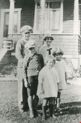
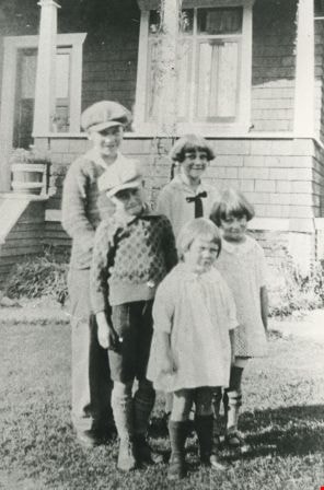
Walker family children
https://search.heritageburnaby.ca/link/archivedescription35370
- Repository
- City of Burnaby Archives
- Date
- 1922 (date of original), copied 1986
- Collection/Fonds
- Burnaby Historical Society fonds
- Description Level
- Item
- Physical Description
- 1 photograph : b&w ; 12.7 x 17.8 cm print
- Scope and Content
- Photograph of the William Walker family children. Back, left to right: James Walker and Helen Walker. Middle, left to right: John Walker and Edith Walker. Front: Maurine Walker. The Walker children are in front of the Walker family home, 2463 Hudson Street (later changed to 6469 Arbroath Street…
- Repository
- City of Burnaby Archives
- Date
- 1922 (date of original), copied 1986
- Collection/Fonds
- Burnaby Historical Society fonds
- Subseries
- Pioneer Tales subseries
- Physical Description
- 1 photograph : b&w ; 12.7 x 17.8 cm print
- Description Level
- Item
- Record No.
- 204-227
- Access Restriction
- No restrictions
- Reproduction Restriction
- No known restrictions
- Accession Number
- BHS1988-03
- Scope and Content
- Photograph of the William Walker family children. Back, left to right: James Walker and Helen Walker. Middle, left to right: John Walker and Edith Walker. Front: Maurine Walker. The Walker children are in front of the Walker family home, 2463 Hudson Street (later changed to 6469 Arbroath Street). William Walker, their father, built this house.
- Media Type
- Photograph
- Notes
- Title based on contents of photograph
- Geographic Access
- Arbroath Street
- Street Address
- 6469 Arbroath Street
- Historic Neighbourhood
- Edmonds (Historic Neighbourhood)
- Planning Study Area
- Kingsway-Beresford Area
Images
6577 Southoaks Cres
https://search.heritageburnaby.ca/link/archivedescription94347
- Repository
- City of Burnaby Archives
- Date
- September 1995
- Collection/Fonds
- Grover, Elliott & Co. Ltd. fonds
- Description Level
- File
- Physical Description
- 25 photographs : col. negatives ; 35 mm
- Scope and Content
- Photographs of the single-family homes and undeveloped properties located on Southoaks Crescent.
- Repository
- City of Burnaby Archives
- Date
- September 1995
- Collection/Fonds
- Grover, Elliott & Co. Ltd. fonds
- Physical Description
- 25 photographs : col. negatives ; 35 mm
- Description Level
- File
- Record No.
- 622-132
- Access Restriction
- No restrictions
- Reproduction Restriction
- No restrictions
- Accession Number
- 2017-39
- Scope and Content
- Photographs of the single-family homes and undeveloped properties located on Southoaks Crescent.
- Subjects
- Buildings - Residential - Houses
- Media Type
- Photograph
- Notes
- Transcribed title
- Title transcribed from envelope photographs were originally housed in
- File no. 95-300-B
- Photographer identified as "J.C."
- Geographic Access
- Southoaks Crescent
- Street Address
- 6445 Arbroath Street
- Historic Neighbourhood
- Edmonds (Historic Neighbourhood)
- Planning Study Area
- Kingsway-Beresford Area