Narrow Results By

Burnett home
https://search.heritageburnaby.ca/link/archivedescription37371
- Repository
- City of Burnaby Archives
- Date
- 1974
- Collection/Fonds
- Burnaby Historical Society fonds
- Description Level
- Item
- Physical Description
- 1 photograph : col. ; 9 x 12.8 cm
- Scope and Content
- Photograph of the home of Mr. Burnett (old street number 6561 Canada Way).
- Repository
- City of Burnaby Archives
- Date
- 1974
- Collection/Fonds
- Burnaby Historical Society fonds
- Subseries
- Photographs subseries
- Physical Description
- 1 photograph : col. ; 9 x 12.8 cm
- Description Level
- Item
- Record No.
- 365-002
- Access Restriction
- No restrictions
- Reproduction Restriction
- Reproduce for fair dealing purposes only
- Accession Number
- BHS2007-04
- Scope and Content
- Photograph of the home of Mr. Burnett (old street number 6561 Canada Way).
- Subjects
- Buildings - Residential - Houses
- Media Type
- Photograph
- Notes
- Title based on caption
- Geographic Access
- Canada Way
- Planning Study Area
- Lakeview-Mayfield Area
Images

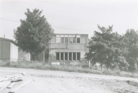
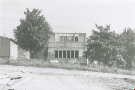
Douglas Road School demolition
https://search.heritageburnaby.ca/link/archivedescription38641
- Repository
- City of Burnaby Archives
- Date
- 1956
- Collection/Fonds
- Burnaby Historical Society fonds
- Description Level
- Item
- Physical Description
- 1 photograph : b&w ; 10 x 15 cm
- Scope and Content
- Photograph of the demolition of the building at the Douglas Road School site.
- Repository
- City of Burnaby Archives
- Date
- 1956
- Collection/Fonds
- Burnaby Historical Society fonds
- Subseries
- Douglas Road School subseries
- Physical Description
- 1 photograph : b&w ; 10 x 15 cm
- Description Level
- Item
- Record No.
- 471-002
- Access Restriction
- No restrictions
- Reproduction Restriction
- Reproduce for fair dealing purposes only
- Accession Number
- BHS2005-3
- Scope and Content
- Photograph of the demolition of the building at the Douglas Road School site.
- Names
- Douglas Road School
- Media Type
- Photograph
- Photographer
- Gordon, Ethel
- Notes
- Title based on contents of photograph
- Geographic Access
- Canada Way
- Street Address
- 4861 Canada Way
- Historic Neighbourhood
- Burnaby Lake (Historic Neighbourhood)
- Planning Study Area
- Douglas-Gilpin Area
Images
![Lubbock farmhouse, [1935] thumbnail](/media/hpo/_Data/_Archives_Images/_Unrestricted/316/342-002.jpg?width=280)
Lubbock farmhouse
https://search.heritageburnaby.ca/link/archivedescription37228
- Repository
- City of Burnaby Archives
- Date
- [1935]
- Collection/Fonds
- Burnaby Historical Society fonds
- Description Level
- Item
- Physical Description
- 1 photograph : sepia ; 5.5 x 8 cm
- Scope and Content
- Photograph of the Lubbock family farmhouse at Burris Street and Canada Way.
- Repository
- City of Burnaby Archives
- Date
- [1935]
- Collection/Fonds
- Burnaby Historical Society fonds
- Subseries
- Lubbock family subseries
- Physical Description
- 1 photograph : sepia ; 5.5 x 8 cm
- Description Level
- Item
- Record No.
- 342-002
- Access Restriction
- No restrictions
- Reproduction Restriction
- No known restrictions
- Accession Number
- BHS1994-02
- Scope and Content
- Photograph of the Lubbock family farmhouse at Burris Street and Canada Way.
- Media Type
- Photograph
- Notes
- Title based on contents of photograph
- Geographic Access
- Grandview Highway
- Canada Way
- Burris Street
- Street Address
- 7803 Burris Street
- Historic Neighbourhood
- Burnaby Lake (Historic Neighbourhood)
- Planning Study Area
- Morley-Buckingham Area
Images
![Lubbock farmhouse, [1935] thumbnail](/media/hpo/_Data/_Archives_Images/_Unrestricted/316/342-002.jpg)
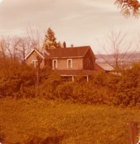
Lubbock's farm house
https://search.heritageburnaby.ca/link/archivedescription36513
- Repository
- City of Burnaby Archives
- Date
- 1977
- Collection/Fonds
- Burnaby Historical Society fonds
- Description Level
- Item
- Physical Description
- 1 photograph : col. ; 9 x 8.5 cm
- Scope and Content
- Photograph of Lubbock's farm house and surrounding trees.
- Repository
- City of Burnaby Archives
- Date
- 1977
- Collection/Fonds
- Burnaby Historical Society fonds
- Subseries
- Lubbock family subseries
- Physical Description
- 1 photograph : col. ; 9 x 8.5 cm
- Description Level
- Item
- Record No.
- 289-002
- Access Restriction
- No restrictions
- Reproduction Restriction
- Reproduce for fair dealing purposes only
- Accession Number
- BHS1992-24
- Scope and Content
- Photograph of Lubbock's farm house and surrounding trees.
- Subjects
- Buildings - Residential - Houses
- Media Type
- Photograph
- Notes
- Title based on contents of photograph
- Geographic Access
- Grandview Highway
- Canada Way
- Burris Street
- Street Address
- 7803 Burris Street
- Historic Neighbourhood
- Burnaby Lake (Historic Neighbourhood)
- Planning Study Area
- Morley-Buckingham Area
Images


Rayside Drive and Canada Way
https://search.heritageburnaby.ca/link/archivedescription39753
- Repository
- City of Burnaby Archives
- Date
- 2002
- Collection/Fonds
- Burnaby Historical Society fonds
- Description Level
- Item
- Physical Description
- 1 photograph : col.; 10 x 15 cm
- Scope and Content
- Photograph of vehicle traffic along Canada Way just past the Rayside Drive intersection.
- Repository
- City of Burnaby Archives
- Date
- 2002
- Collection/Fonds
- Burnaby Historical Society fonds
- Subseries
- Photographs subseries
- Physical Description
- 1 photograph : col.; 10 x 15 cm
- Description Level
- Item
- Record No.
- 442-002
- Access Restriction
- No restrictions
- Reproduction Restriction
- Reproduce for fair dealing purposes only
- Accession Number
- BHS2007-04
- Scope and Content
- Photograph of vehicle traffic along Canada Way just past the Rayside Drive intersection.
- Media Type
- Photograph
- Notes
- Title based on contents of photograph.
- Geographic Access
- Canada Way
- Rayside Street
- Historic Neighbourhood
- Burnaby Lake (Historic Neighbourhood)
- Planning Study Area
- Morley-Buckingham Area
Images

![Ross Service Station, Douglas Road and Grandview Highway, 1930 (date of original), copied [1998] thumbnail](/media/hpo/_Data/_Archives_Images/_Unrestricted/316/358-002.jpg?width=280)
Ross Service Station, Douglas Road and Grandview Highway
https://search.heritageburnaby.ca/link/archivedescription37354
- Repository
- City of Burnaby Archives
- Date
- 1930 (date of original), copied [1998]
- Collection/Fonds
- Burnaby Historical Society fonds
- Description Level
- Item
- Physical Description
- 1 photograph : b&w ; 10 x 15 cm print
- Scope and Content
- Photograph of a man on a motorcycle, most likely Fred Ross's assistant, Terry Rowley, outside the Ross Service Station at Douglas road and Grandview Highway (now Canada Way). This station was built, owned and operated by Fred Ross.
- Repository
- City of Burnaby Archives
- Date
- 1930 (date of original), copied [1998]
- Collection/Fonds
- Burnaby Historical Society fonds
- Subseries
- Ross family subseries
- Physical Description
- 1 photograph : b&w ; 10 x 15 cm print
- Description Level
- Item
- Record No.
- 358-002
- Access Restriction
- No restrictions
- Reproduction Restriction
- No known restrictions
- Accession Number
- BHS1998-05
- Scope and Content
- Photograph of a man on a motorcycle, most likely Fred Ross's assistant, Terry Rowley, outside the Ross Service Station at Douglas road and Grandview Highway (now Canada Way). This station was built, owned and operated by Fred Ross.
- Names
- Ross Service Station
- Media Type
- Photograph
- Notes
- Title based on contents of photograph.
- The 1925 Burnaby Business Guide gives the address of this site as Douglas Road and Sprott Street.
- Geographic Access
- Douglas Road
- Sprott Street
- Canada Way
- Planning Study Area
- Douglas-Gilpin Area
Images
![Ross Service Station, Douglas Road and Grandview Highway, 1930 (date of original), copied [1998] thumbnail](/media/hpo/_Data/_Archives_Images/_Unrestricted/316/358-002.jpg)
![Saint Theresa's Roman Catholic Church, [between 1970 and 1974] thumbnail](/media/Hpo/_Data/_Archives_Images/_Unrestricted/205/237-002.jpg?width=280)
Saint Theresa's Roman Catholic Church
https://search.heritageburnaby.ca/link/archivedescription36219
- Repository
- City of Burnaby Archives
- Date
- [between 1970 and 1974]
- Collection/Fonds
- Burnaby Historical Society fonds
- Description Level
- Item
- Physical Description
- 1 photograph : col. ; 17 x 12.5 cm
- Scope and Content
- Photograph of Jack Sims and John Aloysius "Jack" McGeachie sitting on the front steps of St. Theresa's Church. Both men are dressed in white.The church was located at the southeast corner of Canada Way and Laurel Street. Built in 1929, it was torn down in 1974, and a new church, St.Theresa's Parish…
- Repository
- City of Burnaby Archives
- Date
- [between 1970 and 1974]
- Collection/Fonds
- Burnaby Historical Society fonds
- Subseries
- Pixie McGeachie subseries
- Physical Description
- 1 photograph : col. ; 17 x 12.5 cm
- Description Level
- Item
- Record No.
- 237-002
- Access Restriction
- No restrictions
- Reproduction Restriction
- Reproduce for fair dealing purposes only
- Accession Number
- BHS1989-28
- Scope and Content
- Photograph of Jack Sims and John Aloysius "Jack" McGeachie sitting on the front steps of St. Theresa's Church. Both men are dressed in white.The church was located at the southeast corner of Canada Way and Laurel Street. Built in 1929, it was torn down in 1974, and a new church, St.Theresa's Parish, was built across the street.
- Subjects
- Buildings - Religious - Churches
- Media Type
- Photograph
- Notes
- Title based on contents of photograph
- Geographic Access
- Laurel Street
- Canada Way
- Historic Neighbourhood
- Burnaby Lake (Historic Neighbourhood)
- Planning Study Area
- Douglas-Gilpin Area
Images
![Saint Theresa's Roman Catholic Church, [between 1970 and 1974] thumbnail](/media/Hpo/_Data/_Archives_Images/_Unrestricted/205/237-002.jpg)
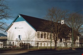
Schou Education Centre
https://search.heritageburnaby.ca/link/archivedescription39751
- Repository
- City of Burnaby Archives
- Date
- 2002
- Collection/Fonds
- Burnaby Historical Society fonds
- Description Level
- Item
- Physical Description
- 1 photograph : col. ; 10 x 15.1 cm
- Scope and Content
- Photograph of the Schou Education Centre on Canada Way. This was formerly the Schou Street School (1914-1979). In 1980 it re-opened as a staff training centre for School District No. 41.
- Repository
- City of Burnaby Archives
- Date
- 2002
- Collection/Fonds
- Burnaby Historical Society fonds
- Subseries
- Photographs subseries
- Physical Description
- 1 photograph : col. ; 10 x 15.1 cm
- Description Level
- Item
- Record No.
- 440-002
- Access Restriction
- No restrictions
- Reproduction Restriction
- Reproduce for fair dealing purposes only
- Accession Number
- BHS2007-04
- Scope and Content
- Photograph of the Schou Education Centre on Canada Way. This was formerly the Schou Street School (1914-1979). In 1980 it re-opened as a staff training centre for School District No. 41.
- Subjects
- Buildings - Schools
- Media Type
- Photograph
- Notes
- Title based on contents of photograph
- Geographic Access
- Canada Way
- Street Address
- 4054 Norfolk Street
- Historic Neighbourhood
- Broadview (Historic Neighbourhood)
- Planning Study Area
- Cascade-Schou Area
Images

![Trick Jumping, [1939] thumbnail](/media/Hpo/_Data/_Archives_Images/_Unrestricted/251/286-002.jpg?width=280)
Trick Jumping
https://search.heritageburnaby.ca/link/archivedescription36507
- Repository
- City of Burnaby Archives
- Date
- [1939]
- Collection/Fonds
- Burnaby Historical Society fonds
- Description Level
- Item
- Physical Description
- 1 photograph : b&w copy negative ; 7 x 9 cm
- Scope and Content
- Photograph of Bud Oddy and Ainsly Lubbock jumping horses over a small fence, while a large crowd watches from the bleachers in the background. This photograph was taken at the Burnaby Lake Riding Academy at the Lubbock farm, 3455 Grandview Highway (old street numbering system). Ainsly Lubbock is t…
- Repository
- City of Burnaby Archives
- Date
- [1939]
- Collection/Fonds
- Burnaby Historical Society fonds
- Subseries
- Lubbock family subseries
- Physical Description
- 1 photograph : b&w copy negative ; 7 x 9 cm
- Description Level
- Item
- Record No.
- 286-002
- Access Restriction
- No restrictions
- Reproduction Restriction
- No known restrictions
- Accession Number
- BHS1992-17
- Scope and Content
- Photograph of Bud Oddy and Ainsly Lubbock jumping horses over a small fence, while a large crowd watches from the bleachers in the background. This photograph was taken at the Burnaby Lake Riding Academy at the Lubbock farm, 3455 Grandview Highway (old street numbering system). Ainsly Lubbock is the man wearing the fedora.
- Subjects
- Events - Competitions
- Animals - Horses
- Names
- Lubbock, Ainsly
- Oddy, Bud
- Media Type
- Photograph
- Notes
- Title based on contents of photograph
- Geographic Access
- Grandview Highway
- Canada Way
- Burris Street
- Street Address
- 7803 Burris Street
- Historic Neighbourhood
- Burnaby Lake (Historic Neighbourhood)
- Planning Study Area
- Morley-Buckingham Area
Images
![Trick Jumping, [1939] thumbnail](/media/Hpo/_Data/_Archives_Images/_Unrestricted/251/286-002.jpg)
![Aerial photograph of the Burnaby Village area, [1946] (date of original), copied 1991 thumbnail](/media/hpo/_Data/_Archives_Images/_Unrestricted/370/370-532.jpg?width=280)
Aerial photograph of the Burnaby Village area
https://search.heritageburnaby.ca/link/archivedescription37945
- Repository
- City of Burnaby Archives
- Date
- [1946] (date of original), copied 1991
- Collection/Fonds
- Burnaby Historical Society fonds
- Description Level
- Item
- Physical Description
- 1 photograph : b&w ; 3.5 x 4.4 cm print on contact sheet 20.5 x 26.7 cm
- Scope and Content
- Aerial photograph of the Sperling Avenue/Douglas Road Burnaby Village area.
- Repository
- City of Burnaby Archives
- Date
- [1946] (date of original), copied 1991
- Collection/Fonds
- Burnaby Historical Society fonds
- Subseries
- Burnaby Image Bank subseries
- Physical Description
- 1 photograph : b&w ; 3.5 x 4.4 cm print on contact sheet 20.5 x 26.7 cm
- Description Level
- Item
- Record No.
- 370-532
- Access Restriction
- No restrictions
- Reproduction Restriction
- No known restrictions
- Accession Number
- BHS1999-03
- Scope and Content
- Aerial photograph of the Sperling Avenue/Douglas Road Burnaby Village area.
- Subjects
- Aerial Photographs
- Media Type
- Photograph
- Notes
- Title based on contents of photograph
- 1 b&w copy negative accompanying
- Negative has a pink cast
- Geographic Access
- Douglas Road
- Sperling Avenue
- Canada Way
- Historic Neighbourhood
- Burnaby Lake (Historic Neighbourhood)
Images
![Aerial photograph of the Burnaby Village area, [1946] (date of original), copied 1991 thumbnail](/media/hpo/_Data/_Archives_Images/_Unrestricted/370/370-532.jpg)

A Pig's Tale
https://search.heritageburnaby.ca/link/museumdescription14365
- Repository
- Burnaby Village Museum
- Date
- Oct. 2020
- Collection/Fonds
- Burnaby Village Museum fonds
- Description Level
- Item
- Physical Description
- 3 video recordings (mp4) (5 min., 28 sec.) : digital, col., sd., stereo, subtitles
- Scope and Content
- Item consists of part two in a two part video series "A Taste of History" created by Debbie Liang and Joty Gill, University of British Columbia alumni and graduates from the Asian Canadian & Asian Migration Studies program (ACAM). Part two is titled "A Pig's Tale". The film highlights the history o…
- Repository
- Burnaby Village Museum
- Collection/Fonds
- Burnaby Village Museum fonds
- Series
- UBC Partnership series
- Description Level
- Item
- Physical Description
- 3 video recordings (mp4) (5 min., 28 sec.) : digital, col., sd., stereo, subtitles
- Material Details
- Script: Debbie Liang; Joty Gill Narration: Joty Gill Editor: Debbie Liang Subtitles: English; Simplified Chinese; Traditional Chinese Video Appearances: Kathy Lee; Eleanor Lee Illustrations and Animations: Debbie Liang Photos, Images & B-roll: Piggery photo, image courtesy of Elwin Xie; Douglas Road: City of Burnaby Archives, 477-841; Canada Way, City of Burnaby Archives, 556-522, photo by Peg Campbell; Red pig by Debbie Liang; Piglets sleeping, image courtesy of RoyBuri from pixabay, free to use; Chinese Zodiac, image courtesy of RoofOfAllLight from wikimedia, Creative Commons Attribution-Share Alike 4.0 International license; Pictograph for Home by Debbie Liang; Pigs lying down, image courtesy of Elwin Xie; Council minutes all from heritageburnaby.com; Cleanliness illustration set by Debbie Liang; "The Heathen Chinese in British Columbia" from Library and Archives Canada; Laundryman spitting from Daily News, Prince Rupert in 1911; Slicer on counter at Way Sang Yuen Wat Kee & Co., Burnaby Village Museum BV017.7.290; Way Sang Yuen Wat Kee & Co. Store front, Burnaby Village Museum BV017.7.191; Medical Practices Disagreement illustration by Debbie Liang; Butchering pig, image courtesy of Elwin Xie; Chinatown brolls, courtesy of Food2 group from UBC's 2019 ACAM 390 Class; Black Rotary telephone beside ball pen on white printed paper, image courtesy of Pixabay from pexels.com, free to use; Burnaby Lake on a cloudy day, image courtesy of Flying Pegunin from wikipedia; The Vancouver Sun May 4, 1921 from newspapers.com; Vancouver Daily May 3, 1921 from newspapers.com; Reduce number of pigs illustration by Debbie Liang; Black and white photo of piggery, image courtesy of Elwin Xie; 2019 Piggery illustration by Debbie Liang Music and Sound Effects: "Acoustic Mediation 2" from audionautix; Pig Grunting sounds from Kiddopedia Animasl, Creative Commons 0; "Piano moment" & "November" from bensound.com; "Ding sound effect" from freesoundlibrary; Wuxia2_Guzheng_Pipa by PeriTune http://peritune.com; Music promoted by https://www.free-stock-music.com; Attribution 4.0 International (CC BY 4.0) https://creativecommons.org/licenses/by/4.0/ Video adapted from 2019 BVM intern project by Debbie Liang and Marcela Gomez Special thanks to: UBC: Joanna Yang, Jenny Lu, Denise Fong, Henry Yu; BVM: Kate Petrusa, Amy Wilson Changes to music may have been made for the purposes of this video
- Scope and Content
- Item consists of part two in a two part video series "A Taste of History" created by Debbie Liang and Joty Gill, University of British Columbia alumni and graduates from the Asian Canadian & Asian Migration Studies program (ACAM). Part two is titled "A Pig's Tale". The film highlights the history of Chinese pig farms also known as "Piggeries" in Burnaby. The film tells the story of how many of these farms were established by Chinese immigrants along Douglas Road (now Canada Way) between the 1890s and 1920s; the importance of the pig in the Chinese Culture as well as a way for Chinese immigrants to make a living and the racism and discriminatory bylaws that the Chinese pig farmers suffered that finally led to the closure of many of these farms. Content references three documented piggery ranches along Douglas Road: Ah Sam; Young Chung and Hop Hin Yen. The films are supported with voice over in english, subtitles, animation along with historical photographs. One version of the film is supported with subtitles in English while two other versions of the film are supported with subtitles in Simplified Chinese and Traditional Chinese.
- History
- In 2020, due to the restrictions of COVID-19, University of British Columbia student interns with the Burnaby Village Museum Chinese Canadian History in Burnaby project were asked to create virtual experiences to reimagine Burnaby Village Museum's historical Chinese Canadian programming in remote online spaces. Debbie Liang and Joty Gill (UBC alumni and graduates of Dr. Henry Yu's 2019 summer ACAM 390A Global Seminar to Aisa) returned to work with Burnaby Village Museum to create two short films showcasing the history of Chinese Canadian Chop Suey restaurants and piggeries in Burnaby.
- Creator
- Liang, Debbie
- Debbie Liang
- Subjects
- Persons - Chinese Canadians
- Social Issues - Discrimination
- Social Issues - Racism
- Regulations
- Agriculture
- Agriculture - Farms
- Agriculture - Ranches
- Animals - Pigs
- Names
- Liang, Debbie
- Gill, Joty
- Burnaby Village Museum
- University of British Columbia
- Xie, Elwin
- Way Sang Yuen Wat Kee & Company
- Ah Sam
- Young Chung
- Hop Hin Yen
- Responsibility
- University of British Columbia
- UBC Initiative for Student Teaching and Research in Chinese Canadian Studies
- Burnaby Village Museum
- Geographic Access
- Douglas Road
- Canada Way
- Accession Code
- BV020.28.7
- Access Restriction
- No restrictions
- Reproduction Restriction
- No known restrictions
- Date
- Oct. 2020
- Media Type
- Moving Images
- Historic Neighbourhood
- Burnaby Lake (Historic Neighbourhood)
- Planning Study Area
- Douglas-Gilpin Area
- Notes
- Transcribed title
Images


Video
A Pig's Tale, Oct. 2020
A Pig's Tale, Oct. 2020
https://search.heritageburnaby.ca/media/hpo/_Data/_BVM_Moving_Images/2020_0028_0007_001.mp4
Barn at Lubbock's farm
https://search.heritageburnaby.ca/link/archivedescription36520
- Repository
- City of Burnaby Archives
- Date
- 1977
- Collection/Fonds
- Burnaby Historical Society fonds
- Description Level
- Item
- Physical Description
- 1 photograph : col. ; 9 x 8.5 cm
- Scope and Content
- Photograph of the horse barn at Lubbock's farm. Both the Burnaby Lake Riding Academy and the Burnaby Lake Saddle Club operated out of the Lubbock farm.
- Repository
- City of Burnaby Archives
- Date
- 1977
- Collection/Fonds
- Burnaby Historical Society fonds
- Subseries
- Lubbock family subseries
- Physical Description
- 1 photograph : col. ; 9 x 8.5 cm
- Description Level
- Item
- Record No.
- 289-009
- Access Restriction
- No restrictions
- Reproduction Restriction
- Reproduce for fair dealing purposes only
- Accession Number
- BHS1992-24
- Scope and Content
- Photograph of the horse barn at Lubbock's farm. Both the Burnaby Lake Riding Academy and the Burnaby Lake Saddle Club operated out of the Lubbock farm.
- Subjects
- Buildings - Agricultural - Barns
- Media Type
- Photograph
- Notes
- Title based on contents of photograph
- Geographic Access
- Grandview Highway
- Canada Way
- Burris Street
- Street Address
- 7803 Burris Street
- Historic Neighbourhood
- Burnaby Lake (Historic Neighbourhood)
- Planning Study Area
- Morley-Buckingham Area
Images

![Bernard Hill family, [1920] (date of original), copied 1986 thumbnail](/media/hpo/_Data/_Archives_Images/_Unrestricted/204/204-790.jpg?width=280)
Bernard Hill family
https://search.heritageburnaby.ca/link/archivedescription35930
- Repository
- City of Burnaby Archives
- Date
- [1920] (date of original), copied 1986
- Collection/Fonds
- Burnaby Historical Society fonds
- Description Level
- Item
- Physical Description
- 1 photograph : b&w ; 12.7 x 17.8 cm print
- Scope and Content
- Photograph of Hill family members taken at the Bernard Hill farm. Identified: Bernard R. Hill (on right).
- Repository
- City of Burnaby Archives
- Date
- [1920] (date of original), copied 1986
- Collection/Fonds
- Burnaby Historical Society fonds
- Subseries
- Pioneer Tales subseries
- Physical Description
- 1 photograph : b&w ; 12.7 x 17.8 cm print
- Description Level
- Item
- Record No.
- 204-790
- Access Restriction
- No restrictions
- Reproduction Restriction
- No known restrictions
- Accession Number
- BHS1988-03
- Scope and Content
- Photograph of Hill family members taken at the Bernard Hill farm. Identified: Bernard R. Hill (on right).
- Names
- Hill, Bernard R.
- Media Type
- Photograph
- Notes
- Title based on contents of photograph
- Geographic Access
- Canada Way
- Street Address
- 4990 Canada Way
- Historic Neighbourhood
- Burnaby Lake (Historic Neighbourhood)
- Planning Study Area
- Douglas-Gilpin Area
Images
![Bernard Hill family, [1920] (date of original), copied 1986 thumbnail](/media/hpo/_Data/_Archives_Images/_Unrestricted/204/204-790.jpg)
![Bernard Hill farm, [190-] (date of original), copied 1986 thumbnail](/media/hpo/_Data/_Archives_Images/_Unrestricted/204/204-789.jpg?width=280)
Bernard Hill farm
https://search.heritageburnaby.ca/link/archivedescription35929
- Repository
- City of Burnaby Archives
- Date
- [190-] (date of original), copied 1986
- Collection/Fonds
- Burnaby Historical Society fonds
- Description Level
- Item
- Physical Description
- 1 photograph : b&w ; 12.7 x 17.8 cm print
- Scope and Content
- Photograph of the Hill brothers Frank, Claude and Gerry and their pet dog riding on hay wagon on their father's farm.
- Repository
- City of Burnaby Archives
- Date
- [190-] (date of original), copied 1986
- Collection/Fonds
- Burnaby Historical Society fonds
- Subseries
- Pioneer Tales subseries
- Physical Description
- 1 photograph : b&w ; 12.7 x 17.8 cm print
- Description Level
- Item
- Record No.
- 204-789
- Access Restriction
- No restrictions
- Reproduction Restriction
- No restrictions
- Accession Number
- BHS1988-03
- Scope and Content
- Photograph of the Hill brothers Frank, Claude and Gerry and their pet dog riding on hay wagon on their father's farm.
- Subjects
- Animals - Dogs
- Transportation - Horses
- Agriculture - Crops
- Agricultural Tools and Equipment
- Media Type
- Photograph
- Notes
- Title based on contents of photograph
- Geographic Access
- Douglas Road
- Canada Way
- Street Address
- 4990 Canada Way
- Historic Neighbourhood
- Burnaby Lake (Historic Neighbourhood)
- Planning Study Area
- Douglas-Gilpin Area
Images
![Bernard Hill farm, [190-] (date of original), copied 1986 thumbnail](/media/hpo/_Data/_Archives_Images/_Unrestricted/204/204-789.jpg)
![Bill Dunbar, [1938] (date of original), copied 1991 thumbnail](/media/hpo/_Data/_Archives_Images/_Unrestricted/370/370-546.jpg?width=280)
Bill Dunbar
https://search.heritageburnaby.ca/link/archivedescription37959
- Repository
- City of Burnaby Archives
- Date
- [1938] (date of original), copied 1991
- Collection/Fonds
- Burnaby Historical Society fonds
- Description Level
- Item
- Physical Description
- 1 photograph : b&w ; 3.4 x 2.4 cm print on contact sheet 20.6 x 26.1 cm
- Scope and Content
- Photograph of Bill Dunbar working in a field at Sperling Avenue and Douglas Road.
- Repository
- City of Burnaby Archives
- Date
- [1938] (date of original), copied 1991
- Collection/Fonds
- Burnaby Historical Society fonds
- Subseries
- Burnaby Image Bank subseries
- Physical Description
- 1 photograph : b&w ; 3.4 x 2.4 cm print on contact sheet 20.6 x 26.1 cm
- Description Level
- Item
- Record No.
- 370-546
- Access Restriction
- No restrictions
- Reproduction Restriction
- No known restrictions
- Accession Number
- BHS1999-03
- Scope and Content
- Photograph of Bill Dunbar working in a field at Sperling Avenue and Douglas Road.
- Names
- Dunbar, Bill
- Media Type
- Photograph
- Notes
- Title based on contents of photograph
- 1 b&w copy negative accompanying
- Geographic Access
- Canada Way
- Sperling Avenue
- Historic Neighbourhood
- Burnaby Lake (Historic Neighbourhood)
- Planning Study Area
- Morley-Buckingham Area
Images
![Bill Dunbar, [1938] (date of original), copied 1991 thumbnail](/media/hpo/_Data/_Archives_Images/_Unrestricted/370/370-546.jpg)
![Blacksmith on Lubbock Farm, [194-] (date of original), copied 1986 thumbnail](/media/hpo/_Data/_Archives_Images/_Unrestricted/204/204-724.jpg?width=280)
Blacksmith on Lubbock Farm
https://search.heritageburnaby.ca/link/archivedescription35865
- Repository
- City of Burnaby Archives
- Date
- [194-] (date of original), copied 1986
- Collection/Fonds
- Burnaby Historical Society fonds
- Description Level
- Item
- Physical Description
- 1 photograph : b&w ; 12.7 x 17.8 cm print
- Scope and Content
- Photograph of John Lubbock working as the farm blacksmith on the Lubbock farm.
- Repository
- City of Burnaby Archives
- Date
- [194-] (date of original), copied 1986
- Collection/Fonds
- Burnaby Historical Society fonds
- Subseries
- Pioneer Tales subseries
- Physical Description
- 1 photograph : b&w ; 12.7 x 17.8 cm print
- Description Level
- Item
- Record No.
- 204-724
- Access Restriction
- No restrictions
- Reproduction Restriction
- Reproduce for fair dealing purposes only
- Accession Number
- BHS1988-03
- Scope and Content
- Photograph of John Lubbock working as the farm blacksmith on the Lubbock farm.
- Subjects
- Occupations - Blacksmiths
- Names
- Lubbock, John
- Media Type
- Photograph
- Notes
- Title based on contents of photograph.
- A note with this photograph indicated the old address of the farm was 1 Arbor Lane.
- Geographic Access
- Grandview Highway
- Canada Way
- Burris Street
- Street Address
- 7803 Burris Street
- Historic Neighbourhood
- Burnaby Lake (Historic Neighbourhood)
- Planning Study Area
- Morley-Buckingham Area
Images
![Blacksmith on Lubbock Farm, [194-] (date of original), copied 1986 thumbnail](/media/hpo/_Data/_Archives_Images/_Unrestricted/204/204-724.jpg)

Bob Hutton at Municipal Hall
https://search.heritageburnaby.ca/link/archivedescription37294
- Repository
- City of Burnaby Archives
- Date
- 1958
- Collection/Fonds
- Burnaby Historical Society fonds
- Description Level
- Item
- Physical Description
- 1 photograph : b&w ; 9 x 9 cm
- Scope and Content
- Photograph of a man identified as Bob Hutton outside Burnaby Municipal Hall. Two other men are visible in the picture, but neither is identified.
- Repository
- City of Burnaby Archives
- Date
- 1958
- Collection/Fonds
- Burnaby Historical Society fonds
- Subseries
- Norah Code subseries
- Physical Description
- 1 photograph : b&w ; 9 x 9 cm
- Description Level
- Item
- Record No.
- 345-015
- Access Restriction
- No restrictions
- Reproduction Restriction
- Reproduce for fair dealing purposes only
- Accession Number
- BHS1997-05
- Scope and Content
- Photograph of a man identified as Bob Hutton outside Burnaby Municipal Hall. Two other men are visible in the picture, but neither is identified.
- Subjects
- Buildings - Civic - City Halls
- Names
- Hutton, Bob
- Burnaby City Hall
- Media Type
- Photograph
- Photographer
- Code, Norah
- Notes
- Title based on contents of photograph.
- Photographs in this collection were taken and compiled by Norah Code, former editor of the "Burnaby Courier" newspaper during the course of her work for the newspaper.
- Geographic Access
- Canada Way
- Street Address
- 4949 Canada Way
- Historic Neighbourhood
- Burnaby Lake (Historic Neighbourhood)
- Planning Study Area
- Douglas-Gilpin Area
Images


Bob Hutton, outside Burnaby Municipal Hall
https://search.heritageburnaby.ca/link/archivedescription37300
- Repository
- City of Burnaby Archives
- Date
- 1958
- Collection/Fonds
- Burnaby Historical Society fonds
- Description Level
- Item
- Physical Description
- 1 photograph : b&w ; 9.5 x 14.5 cm
- Scope and Content
- Photograph of two men and one woman standing outside Burnaby Municipal Hall reading from a proclamation and addressing a fourth man who is seen to the far right holding a microphone. The microphone bears the call letters CKNW and the man holding it has been identified as Bob Hutton.
- Repository
- City of Burnaby Archives
- Date
- 1958
- Collection/Fonds
- Burnaby Historical Society fonds
- Subseries
- Norah Code subseries
- Physical Description
- 1 photograph : b&w ; 9.5 x 14.5 cm
- Description Level
- Item
- Record No.
- 345-021
- Access Restriction
- No restrictions
- Reproduction Restriction
- Reproduce for fair dealing purposes only
- Accession Number
- BHS1997-05
- Scope and Content
- Photograph of two men and one woman standing outside Burnaby Municipal Hall reading from a proclamation and addressing a fourth man who is seen to the far right holding a microphone. The microphone bears the call letters CKNW and the man holding it has been identified as Bob Hutton.
- Subjects
- Buildings - Civic - City Halls
- Names
- Hutton, Bob
- Burnaby City Hall
- Media Type
- Photograph
- Photographer
- Code, Norah
- Notes
- Photographs in this collection were taken and compiled by Norah Code, former editor of the "Burnaby Courier" newspaper during the course of her work for the newspaper.
- Geographic Access
- Canada Way
- Street Address
- 4949 Canada Way
- Historic Neighbourhood
- Burnaby Lake (Historic Neighbourhood)
- Planning Study Area
- Douglas-Gilpin Area
Images


Broadview School
https://search.heritageburnaby.ca/link/archivedescription38237
- Repository
- City of Burnaby Archives
- Date
- 1912
- Collection/Fonds
- Burnaby Historical Society fonds
- Description Level
- Item
- Physical Description
- 1 photograph : sepia ; 16.5 x 21.2 cm on 24.5 x 29.5 cm backing
- Scope and Content
- Photograph of a class of approximately fifty-three children and two teachers outside the newly built Broadview area school. This was the first class photograph at the Broadview School. This shool was later replaced by the Schou Street School and the building was used as a community centre.
- Repository
- City of Burnaby Archives
- Date
- 1912
- Collection/Fonds
- Burnaby Historical Society fonds
- Subseries
- Margaret McCallum subseries
- Physical Description
- 1 photograph : sepia ; 16.5 x 21.2 cm on 24.5 x 29.5 cm backing
- Description Level
- Item
- Record No.
- 375-012
- Access Restriction
- No restrictions
- Reproduction Restriction
- No known restrictions
- Accession Number
- BHS1986-42
- Scope and Content
- Photograph of a class of approximately fifty-three children and two teachers outside the newly built Broadview area school. This was the first class photograph at the Broadview School. This shool was later replaced by the Schou Street School and the building was used as a community centre.
- Names
- Schou Street School
- Media Type
- Photograph
- Notes
- Title based on contents of photograph
- Geographic Access
- Gilmore Avenue
- Grandview Highway
- Canada Way
- Street Address
- 4054 Norfolk Street
- Historic Neighbourhood
- Broadview (Historic Neighbourhood)
- Planning Study Area
- Cascade-Schou Area
Images

![Burnaby Council, [1956] thumbnail](/media/hpo/_Data/_Archives_Images/_Unrestricted/204/204-803.jpg?width=280)
Burnaby Council
https://search.heritageburnaby.ca/link/archivedescription35943
- Repository
- City of Burnaby Archives
- Date
- [1956]
- Collection/Fonds
- Burnaby Historical Society fonds
- Description Level
- Item
- Physical Description
- 1 photograph : b&w ; 20.3 x 25.4 cm print
- Scope and Content
- Photograph of the Burnaby Council in chambers.
- Repository
- City of Burnaby Archives
- Date
- [1956]
- Collection/Fonds
- Burnaby Historical Society fonds
- Subseries
- Pioneer Tales subseries
- Physical Description
- 1 photograph : b&w ; 20.3 x 25.4 cm print
- Description Level
- Item
- Record No.
- 204-803
- Access Restriction
- No restrictions
- Reproduction Restriction
- Reproduce for fair dealing purposes only
- Accession Number
- BHS1988-03
- Scope and Content
- Photograph of the Burnaby Council in chambers.
- Subjects
- Officials - Alderman and Councillors
- Buildings - Civic - City Halls
- Officials - Mayors and Reeves
- Names
- Burnaby City Hall
- Media Type
- Photograph
- Photographer
- LeBlanc, Don
- Notes
- Title based on contents of photograph
- Geographic Access
- Canada Way
- Street Address
- 4949 Canada Way
- Historic Neighbourhood
- Burnaby Lake (Historic Neighbourhood)
- Planning Study Area
- Douglas-Gilpin Area
Images
![Burnaby Council, [1956] thumbnail](/media/hpo/_Data/_Archives_Images/_Unrestricted/204/204-803.jpg)