Narrow Results By
Subject
- Advertising Medium 1
- Archeological Specimen 31
- Armament 16
- Beverages 1
- Building Components 4
- Building Components - Fireplaces 1
- Buildings - Agricultural 3
- Buildings - Agricultural - Greenhouses 2
- Buildings - Agricultural - Stables 1
- Buildings - Civic - Museums 1
- Buildings - Heritage 10
- Buildings - Judicial - Courthouses 1
Creator
- Adams, John 2
- Albert F. Arnold McCarter & Nairne 1
- Alphonse J. Toebaert 1
- Bernard R. Hill 1
- Bowman and Cullerne 1
- British Columbia Underwriters' Association 1
- Burnett & McGugan, Engineers and Surveyors 1
- Draper, William Nelson 1
- E. Evans and Son 1
- Enoch Evans 1
- Frank William Macey 2
- Fred Laughton Townley 1
Person / Organization
- Allen, James Charles 1
- Bateman, Edwin W. 2
- Bateman, Mary Dale 1
- Bell, Flora 1
- Bell, William 1
- British Columbia Electric Railway 2
- British Columbia Electric Railway Company 1
- Brownlee, James Harrison 1
- Burnaby Civic Employees Union 1
- Burnaby Lake Post Office 1
- Burnaby School Board 1
- Burnaby Village Museum 9

Bird's Eye View of the Burnaby Lake Area
https://search.heritageburnaby.ca/link/museumdescription15144
- Repository
- Burnaby Village Museum
- Date
- 1977
- Collection/Fonds
- Century Park Museum Association fonds
- Description Level
- Item
- Physical Description
- 1 map : b&w print on paper ; 43 x 63.5 cm
- Scope and Content
- Item consists of a map titled "Birds Eye View of the Burnaby Lake Area Circa 1910". The overview of the Burnaby Lake area was compiled and drawn at Heritage Village by curator John Adams and artist, Carol Swan. The map identifies the Burnaby Lake inter-urban tram line; roads including: Sperling Ave…
- Repository
- Burnaby Village Museum
- Collection/Fonds
- Century Park Museum Association fonds
- Description Level
- Item
- Physical Description
- 1 map : b&w print on paper ; 43 x 63.5 cm
- Material Details
- Scale indeterminable
- Scope and Content
- Item consists of a map titled "Birds Eye View of the Burnaby Lake Area Circa 1910". The overview of the Burnaby Lake area was compiled and drawn at Heritage Village by curator John Adams and artist, Carol Swan. The map identifies the Burnaby Lake inter-urban tram line; roads including: Sperling Avenue (Pole Line Road); Gilpin Avenue; Douglas Road; trail to Vancouver Westminster Road (Kingsway); Buckingham Avenue; Haszard Street; various farms and residences including: Charles Sprott "Norland"; H.T. Ceperley "Fairacres"; Claude Hill's "Brookfield farm" and "Broadview"; F.J. Hart's "Avalon"; Miss Woodward's former and new home, school and post office; Councillor Edgar's hunting cabin; Edgar Sprott's "Mayfield farm" and "Mayfield Lodge"; F.J. Peers "Greyfriars"; Arthur de Windt Haszard; Bernard Hill's boathouse as well as other landmarks including: Doran's Mill; tram stations; Burnaby Lake Store; logging camps; wood cutter's shacks; ice houses; cranberry bog; Still Creek; Deer Lake; Burnaby Lake; Deer Lake Creek; Provincial Government Reserve Proposed Hospital (later Oakalla Prison).
- Creator
- Adams, John
- Swan, Carol
- Names
- Hill, Arthur Claude
- Sprott, Charles Frederick
- Sprott, Louis "Edgar"
- Hart, Frederick John, 1884-1945
- Ceperley, H.T.
- Woodward, Maude
- Woodward, Harriet
- Peers, Francis J.
- Haszard, Arthur de Windt
- Hill, Bernard R.
- Geographic Access
- Deer Lake Avenue
- Sperling Avenue
- Haszard Street
- Buckingham Avenue
- Accession Code
- BV021.1.3
- Access Restriction
- No restrictions
- Reproduction Restriction
- No known restrictions
- Date
- 1977
- Media Type
- Cartographic Material
- Historic Neighbourhood
- Burnaby Lake (Historic Neighbourhood)
- Planning Study Area
- Burnaby Lake Area
- Related Material
- See also: Life with the Moores of Hart House : pioneer days on Burnaby's Deer Lake
- Scan Resolution
- 600
- Scan Date
- 2021-11-12
- Scale
- 100
- Notes
- Transcribed title
- Compiled by John Adams; illustration by Carol Swan
- The map depicts the Burnaby Lake Tram Line as being double tracked, whereas in reality it was single tracked.
- Map is part of the book "Life with the Moores of Hart House : pioneer days on Burnaby's Deer Lake https://search.heritageburnaby.ca/permalink/museumlibrary6314-102
Images


Bird's Eye View of the Burnaby Lake Area
https://search.heritageburnaby.ca/link/museumdescription17543
- Repository
- Burnaby Village Museum
- Date
- 1977
- Collection/Fonds
- Century Park Museum Association fonds
- Description Level
- Item
- Physical Description
- 1 map : b&w print with watercolour ; 43 x 63.5 cm
- Scope and Content
- Item consists of a map titled "Birds Eye View of the Burnaby Lake Area Circa 1910". The overview of the Burnaby Lake area was compiled and drawn at Heritage Village by curator John Adams and artist, Carol Swan. The map identifies the Burnaby Lake inter-urban tram line; roads including: Sperling Ave…
- Repository
- Burnaby Village Museum
- Collection/Fonds
- Century Park Museum Association fonds
- Description Level
- Item
- Physical Description
- 1 map : b&w print with watercolour ; 43 x 63.5 cm
- Material Details
- Scale indeterminable
- Scope and Content
- Item consists of a map titled "Birds Eye View of the Burnaby Lake Area Circa 1910". The overview of the Burnaby Lake area was compiled and drawn at Heritage Village by curator John Adams and artist, Carol Swan. The map identifies the Burnaby Lake inter-urban tram line; roads including: Sperling Avenue (Pole Line Road); Gilpin Avenue; Douglas Road; trail to Vancouver Westminster Road (Kingsway); Buckingham Avenue; Haszard Street; various farms and residences including: Charles Sprott "Norland"; H.T. Ceperley "Fairacres"; Claude Hill's "Brookfield farm" and "Broadview"; F.J. Hart's "Avalon"; Miss Woodward's former and new home, school and post office; Councillor Edgar's hunting cabin; Edgar Sprott's "Mayfield farm" and "Mayfield Lodge"; F.J. Peers "Greyfriars"; Arthur de Windt Haszard; Bernard Hill's boathouse as well as other landmarks including: Doran's Mill; tram stations; Burnaby Lake Store; logging camps; wood cutter's shacks; ice houses; cranberry bog; Still Creek; Deer Lake; Burnaby Lake; Deer Lake Creek; Provincial Government Reserve Proposed Hospital (later Oakalla Prison).
- Creator
- Adams, John
- Swan, Carol
- Names
- Hill, Arthur Claude
- Sprott, Charles Frederick
- Sprott, Louis "Edgar"
- Hart, Frederick John, 1884-1945
- Ceperley, H.T.
- Woodward, Maude
- Woodward, Harriet
- Peers, Francis J.
- Haszard, Arthur de Windt
- Hill, Bernard R.
- Geographic Access
- Deer Lake Avenue
- Sperling Avenue
- Haszard Street
- Buckingham Avenue
- Accession Code
- BV021.1.4
- Access Restriction
- No restrictions
- Reproduction Restriction
- No known restrictions
- Date
- 1977
- Media Type
- Cartographic Material
- Historic Neighbourhood
- Burnaby Lake (Historic Neighbourhood)
- Planning Study Area
- Burnaby Lake Area
- Related Material
- See also: Life with the Moores of Hart House : pioneer days on Burnaby's Deer Lake
- Scan Resolution
- 600
- Scan Date
- 2021-11-12
- Scale
- 100
- Notes
- Transcribed title
- Compiled by John Adams; illustration by Carol Swan
- The map depicts the Burnaby Lake Tram Line as being double tracked, whereas in reality it was single tracked.
- Map is part of the book "Life with the Moores of Hart House : pioneer days on Burnaby's Deer Lake https://search.heritageburnaby.ca/permalink/museumlibrary6314-102
- This is a print made from original illustration and appears to be hand-coloured with watercolour at a later date.
Images

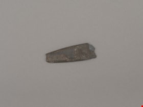
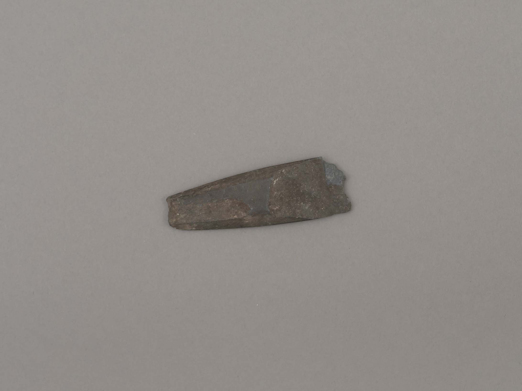
blade or projectile
https://search.heritageburnaby.ca/link/museumartifact44879
- Repository
- Burnaby Village Museum
- Accession Code
- BV002.57.30
- Description
- Ground slate point
- Object History
- The donor inherited this artifact from his mother, Katherine Maude (Kitty) Peers, who inherited them from her father, Louis Claude Hill. The artifacts were found on his farm, Brookfield Farm, at Douglas Road and Sperling Avenue (now site of Burnaby Village Museum).
- Culture Phase: Locarno Beach phase (3520-2200 Before Present)
- Historic Neighbourhood
- Burnaby Lake (Historic Neighbourhood)
Images
Documents
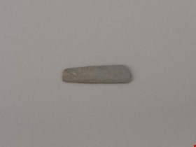
blade or projectile point
https://search.heritageburnaby.ca/link/museumartifact44878
- Repository
- Burnaby Village Museum
- Accession Code
- BV002.57.29
- Description
- Ground and faceted stone point
- Object History
- The donor inherited this artifact from his mother, Katherine Maude (Kitty) Peers, who inherited them from her father, Louis Claude Hill. The artifacts were found on his farm, Brookfield Farm, at Douglas Road and Sperling Avenue (now site of Burnaby Village Museum).
- Culture Phase: Locarno Beach phase (3520-2200 Before Present)
- Historic Neighbourhood
- Burnaby Lake (Historic Neighbourhood)
Images

Documents
bottle
https://search.heritageburnaby.ca/link/museumartifact10433
- Repository
- Burnaby Village Museum
- Accession Code
- BV999.41.1
- Description
- Bottle, ceramic, Chinese Tiger Whiskey; "Ta-Ga-Napi"; brown; globe shape tapers to narrow neck, which flares out around opening; no stopper; inside is light brown; ridged area near bottom; bottom and part of side broken off; some cracks, crazing, two chips on rim; soil adhering to surface
- Object History
- This artifact was found during construction of replacement foundations of Estate Cottage building at Fairacres (now Burnaby Art Gallery). It was found in 1998 during the restoration project.
- Category
- 04.Tools & Equipment for Materials
- Classification
- Food Service T&E - - Drinking Vessels
- Object Term
- Bottle, Drinking
- Subjects
- Persons - Chinese Canadians
- Historic Neighbourhood
- Burnaby Lake (Historic Neighbourhood)
- Planning Study Area
- Douglas-Gilpin Area
Images


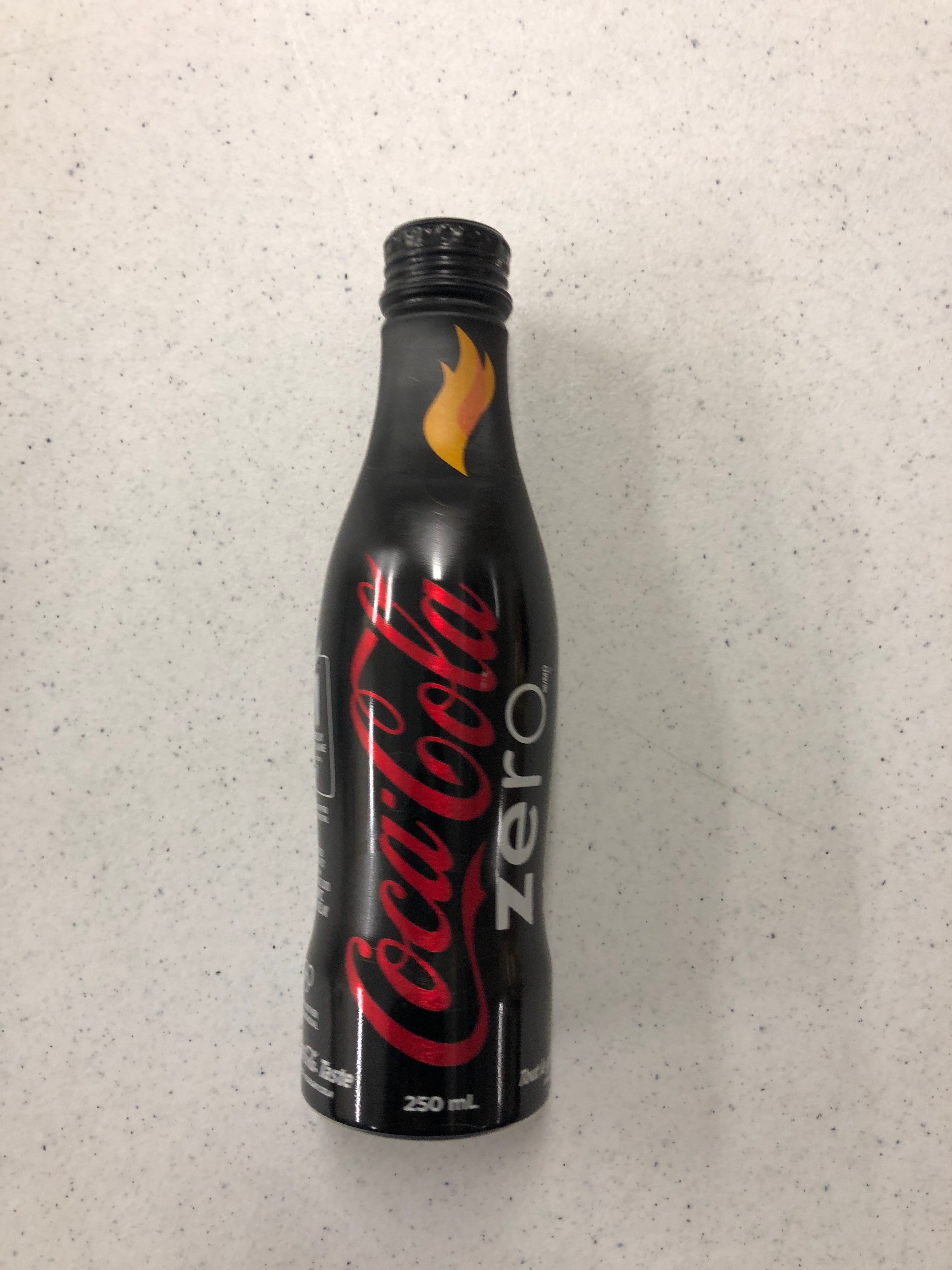
Bottle
https://search.heritageburnaby.ca/link/museumartifact90814
- Repository
- Burnaby Village Museum
- Accession Code
- BV020.40.5
- Description
- A matte black 250ml smooth glass bottle of Coca-cola. The liquid is still inside. The Coca-cola logo is in red, and "ZERO" is in white. There is a yellow and orange flame on the bottle neck. The lid is aluminum and still sealed.
- Object History
- This was a free giveaway from Coca-cola during the 2010 Olympic Torch Relay held in Burnaby's Cultural Complex.
- Classification
- Advertising Media
- Object Term
- Bottle, Sample
- Marks/Labels
- Coca-cola
- Colour
- Black
- White
- Red
- Yellow
- Measurements
- 8 inches high
- Maker
- Coca-cola
- Subjects
- Advertising Medium
- Beverages
- Events
- Historic Neighbourhood
- Burnaby Lake (Historic Neighbourhood)
- Planning Study Area
- Douglas-Gilpin Area
Images
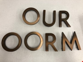
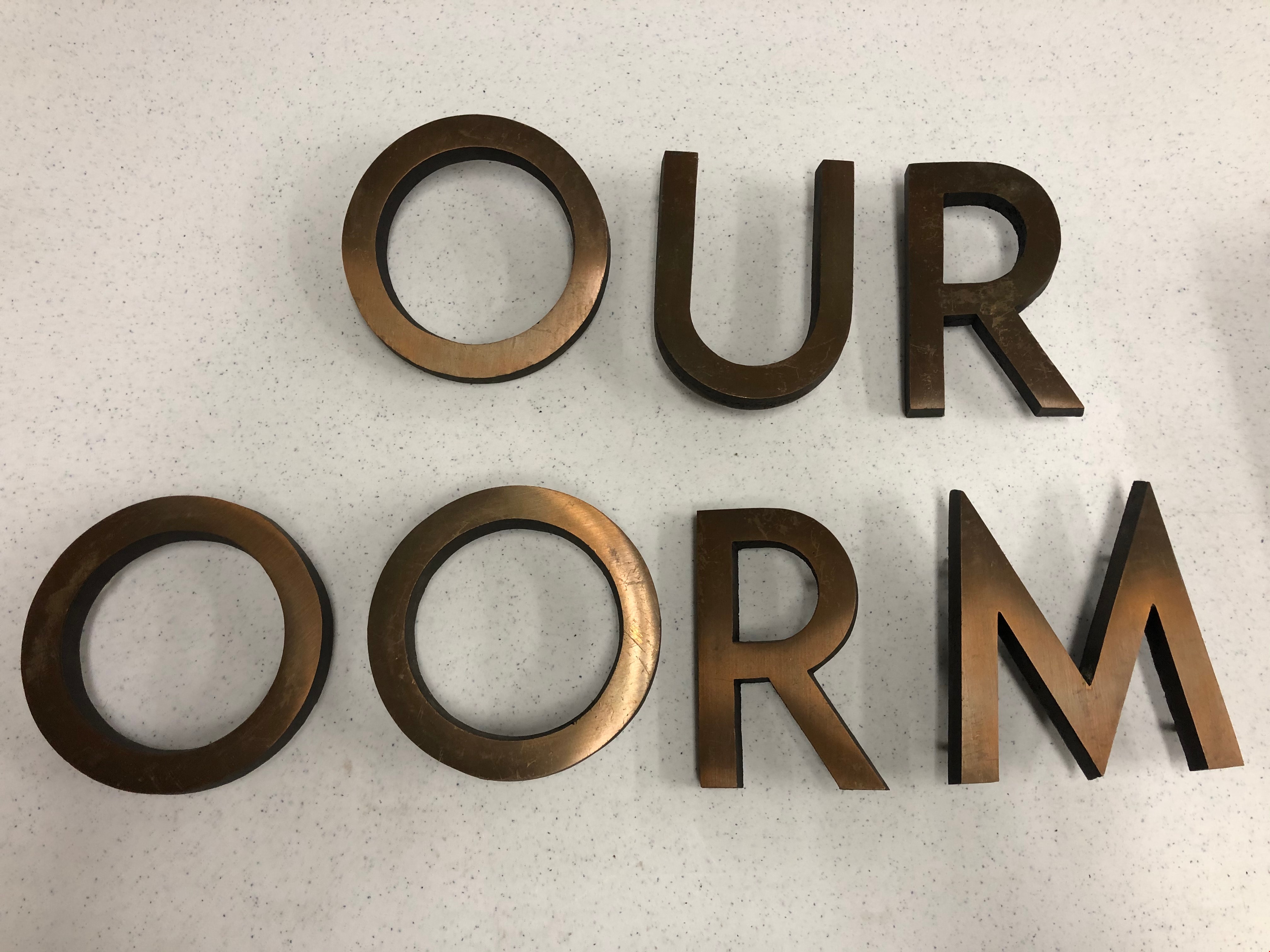
Building Letters
https://search.heritageburnaby.ca/link/museumartifact90803
- Repository
- Burnaby Village Museum
- Accession Code
- BV020.40.1
- Description
- Eight bronze capital letters: "OURT ROOM" Each letter has small protrusions on the backside where they were afixed to the exterior wall of Burnaby's Provincial courtroom.
- Object History
- The Court Room letters came from the 1965 Provincial Courthouse built adjacent to City Hall at 4949 Canada Way. This courtroom closed down in 2002.
- Object Term
- Sign, Identification
- Marks/Labels
- "OUR ROOM" is missing the C and the "T" to finish spelling courtroom.
- Colour
- Bronze
- Measurements
- 6" in height
- Subjects
- Building Components
- Buildings - Judicial - Courthouses
- Government - Provincial Government
- Officials - Judges
- Historic Neighbourhood
- Burnaby Lake (Historic Neighbourhood)
- Planning Study Area
- Douglas-Gilpin Area
Images

candle
https://search.heritageburnaby.ca/link/museumartifact25543
- Repository
- Burnaby Village Museum
- Accession Code
- HV975.61.177
- Description
- Candle, wooden
- Object History
- This candle holder belonged to a family who immigrated to Burnaby in the 1930s at 8006 Government Road.
- Category
- 04.Tools & Equipment for Materials
- Classification
- Lighting Equipment - - Lighting Devices
- Object Term
- Candle
- Subjects
- Lighting Devices
- Historic Neighbourhood
- Burnaby Lake (Historic Neighbourhood)
- Planning Study Area
- Government Road Area
Images


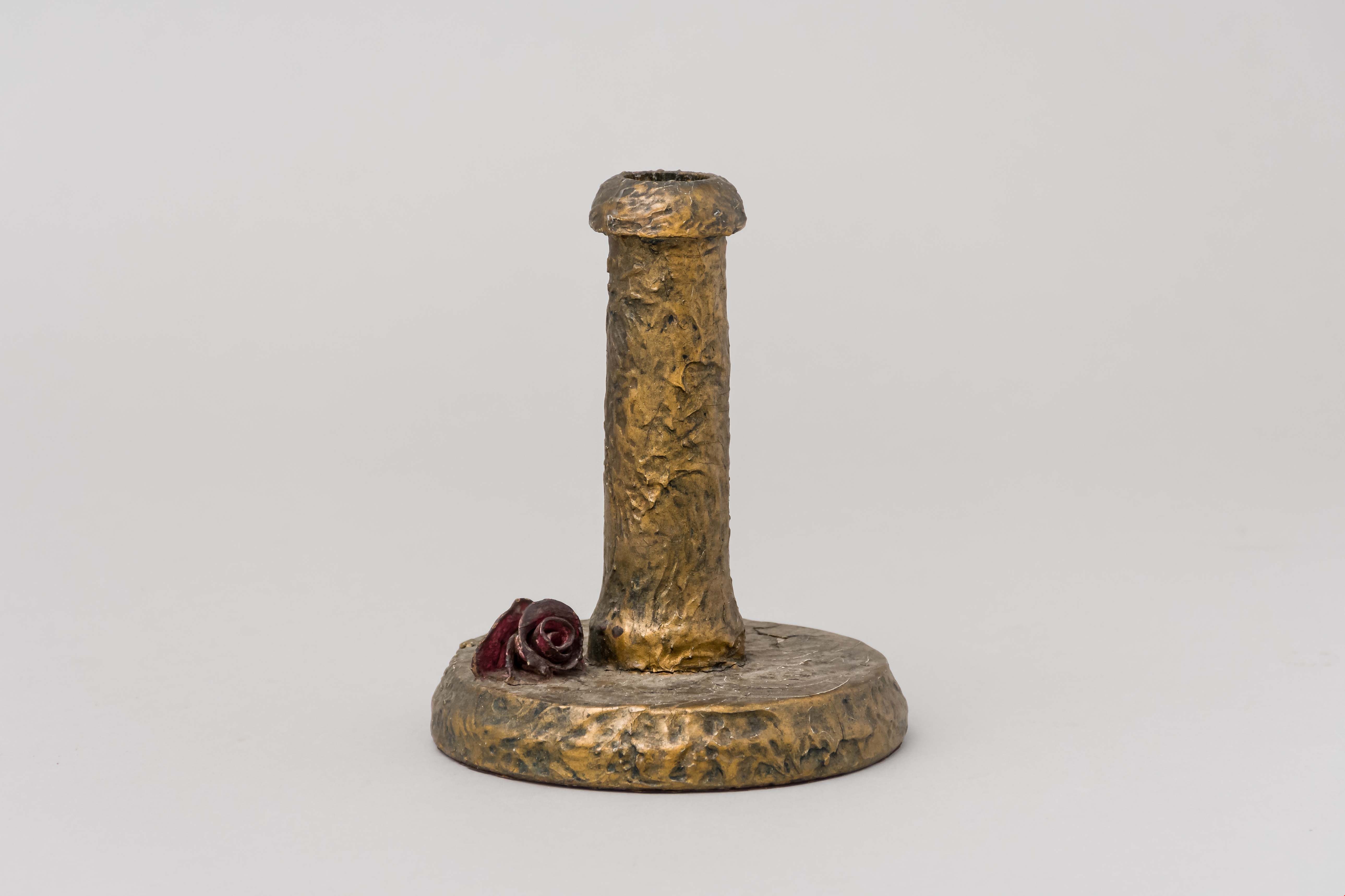
candleholder
https://search.heritageburnaby.ca/link/museumartifact25481
- Repository
- Burnaby Village Museum
- Accession Code
- HV975.61.115
- Description
- Candleholder, composition; painted gold; small moulded rose on base
- Object History
- This candle holder belonged to a family who moved to Burnaby in the 1930s at 8006 Government Road.
- Category
- 02. Furnishings
- Classification
- Lighting Equipment - - Lighting Holders
- Object Term
- Candleholder
- Subjects
- Lighting Devices
- Historic Neighbourhood
- Burnaby Lake (Historic Neighbourhood)
- Planning Study Area
- Government Road Area
Images
candle holder
https://search.heritageburnaby.ca/link/museumartifact86790
- Repository
- Burnaby Village Museum
- Accession Code
- BV016.46.15
- Description
- Candle holder with rubber bottom and wratchet top. The intention was for the rubber to create a suction cup so the holder could stick to a wall. The position of the top is adjustable with a ball and socket-style hinge. Impressed on the side of the candle holder is "THE / NEW LONDON/ T.R.L.W.
- Object History
- Item was found inside lap desk that belonged to Sara Frances Botsford, who lived at 3813 Deer Lake Avenue in 1925. Jack and Sarah raised there three children (Frances, John and Grace) in the house until they retired to Lasqueti Island in 1946. They sold the house to their eldest daughter, Frances and son in law Ray Fleming who lived in the home until 1958. The house and property was sold to the Municipality of Burnaby in 1959 and the site became part of BVM.
- Category
- 02. Furnishings
- Classification
- Lighting Equipment - - Lighting Holders
- Object Term
- Candleholder
- Marks/Labels
- White paper label adhered to bottom of lower writing surface panel reads: "Pin Up Candle Holder. / Bottom was rubber / suction cup which / was supposed to stick / to wall __ / on [sketch of candle stick capital] New London T?RL?"
- Historic Neighbourhood
- Burnaby Lake (Historic Neighbourhood)
- Planning Study Area
- Douglas-Gilpin Area
Images


Douglas Road School site
https://search.heritageburnaby.ca/link/museumdescription11136
- Repository
- Burnaby Village Museum
- Date
- April 19, 1915
- Collection/Fonds
- Ronald G. Scobbie collection
- Description Level
- Item
- Physical Description
- 1 survey plan : blueprint on paper ; 56 x 54 cm
- Scope and Content
- Survey plan of "Douglas Road School Site / Burnaby Municipality" "Being Lot 21, of Blocks 1-5 inc. 11 & 12 of the subd. of north half of Lot 80, Group 1, New Westminster District".
- Repository
- Burnaby Village Museum
- Collection/Fonds
- Ronald G. Scobbie collection
- Description Level
- Item
- Physical Description
- 1 survey plan : blueprint on paper ; 56 x 54 cm
- Material Details
- Scale 40 feet = 1 inch
- Scope and Content
- Survey plan of "Douglas Road School Site / Burnaby Municipality" "Being Lot 21, of Blocks 1-5 inc. 11 & 12 of the subd. of north half of Lot 80, Group 1, New Westminster District".
- Creator
- McGugan, Donald Johnston
- Subjects
- Buildings - Schools
- Names
- Douglas Road School
- Responsibility
- Burnett & McGugan, Engineers and Surveyors
- Geographic Access
- Canada Way
- Street Address
- 4861 Canada Way
- Accession Code
- BV003.83.15
- Access Restriction
- No restrictions
- Reproduction Restriction
- No known restrictions
- Date
- April 19, 1915
- Media Type
- Cartographic Material
- Historic Neighbourhood
- Burnaby Lake (Historic Neighbourhood)
- Planning Study Area
- Douglas-Gilpin Area
- Scan Resolution
- 440
- Scan Date
- 22-Dec-2020
- Scale
- 100
- Notes
- Title based on contents of plan
- Note in black ink on verso of plan reads: "1747"
- Oath on plan reads: "I, D.G. McGugan..." "...and did person- ally superintend the survey..." "...completed on the 3rd day of April 1915"; signed by D.J. McGugan, notarized by "H.A. Eastman", sworn "...19th day of April 1915" "Burnett and McGugan" "B.C. Land Surveyors Etc. New Westminster, B.C.."
Images

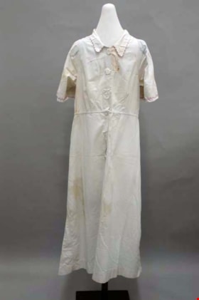
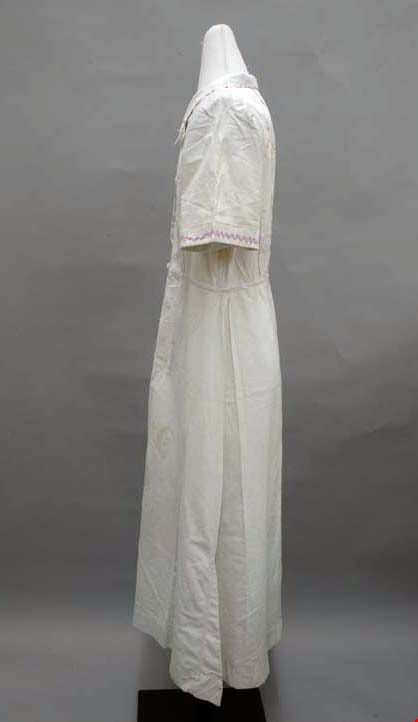
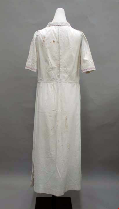
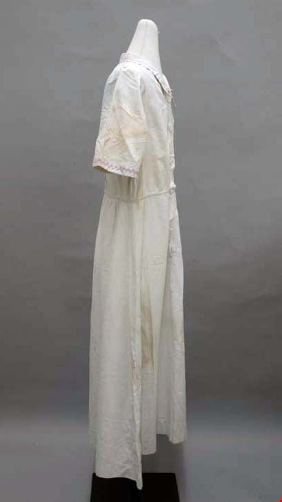
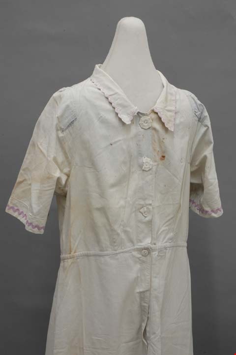
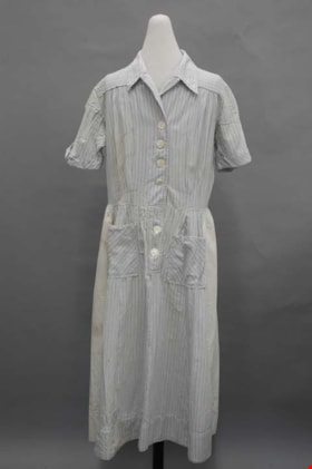
dress
https://search.heritageburnaby.ca/link/museumartifact39966
- Repository
- Burnaby Village Museum
- Accession Code
- BV999.28.5
- Description
- Dress, c.1930s. Light blue cotton with rayon rick-rack trim and celluloid buttons. The button-front bodice is fitted with darts, and the skirt is knee length. The close collar is edged with purple rayon rick-rack ribbon. The centre front opens with three white octagonal celluloid buttons, and it is shaped with darts: two on each side panel front and back, and one on each shoulder front and back. There is also an inverted box pleat inserted into the centre back, closed at its top and bottom, for ease. At the end of each short sleeve there is the same purple trim as on the collar. The centre front opening continues through the natural waistline, with two hidden circular white celluloid buttons. There is a front and back slightly flared panel to the skirt, plus two godets on either side of each side seam. The trim and the rest of the garment is machine sewn, with flat felled seams.
- Object History
- Donor inherited object from her mother and grandmother, ca. 1994.
- Subjects
- Clothing
- Clothing - Costumes
- Historic Neighbourhood
- Burnaby Lake (Historic Neighbourhood)
- Planning Study Area
- Burnaby Lake Area
Images
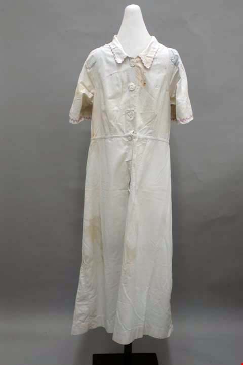
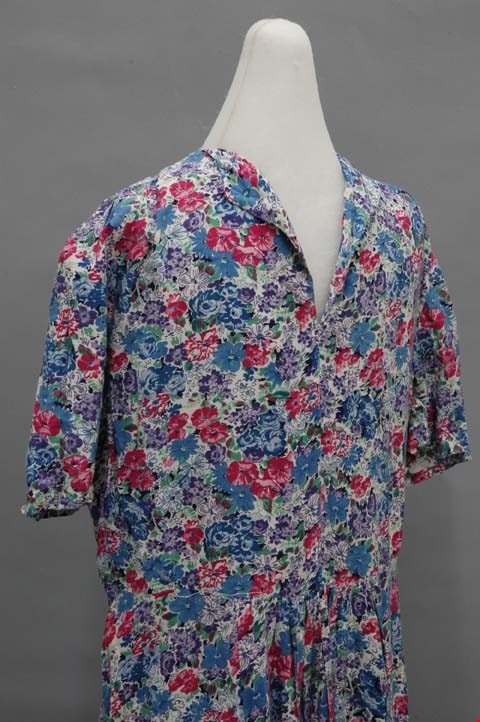
dress
https://search.heritageburnaby.ca/link/museumartifact39967
- Repository
- Burnaby Village Museum
- Accession Code
- BV999.28.6
- Description
- Dress, c.1940s. Floral cotton print with faced collar in neckline, gathered skirt, short sleeves, calf length hem. Hand made by donor's grandmother. The dress is made with a pink, blue, purple and green floral print in the 1940s style. The collar is sewn with a facing out of a split down the centre front. The shoulders are gathered at the front, and the double fold hem for the short sleeves are hand finished. The bodice slants slightly inward towards the natural waistline; other than that, there is no shaping for this easy fitting dress. The skirt has eight gores, each somewhat flared. It is gathered quite a bit in the centre front gore, and slightly at centre back. The hem extends to the calves; it is hand finished. All of the seams are unfinished and all machine sewn.
- Object History
- Donor inherited object from her grandmother, ca. 1994. This dress was homemade, but was never worn.
- Subjects
- Clothing
- Clothing - Costumes
- Historic Neighbourhood
- Burnaby Lake (Historic Neighbourhood)
- Planning Study Area
- Burnaby Lake Area
Images
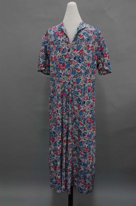
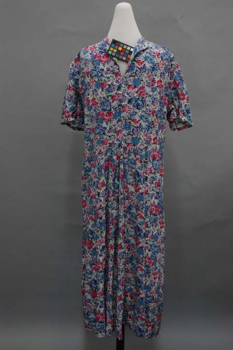
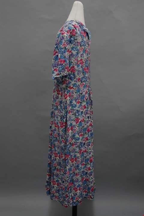
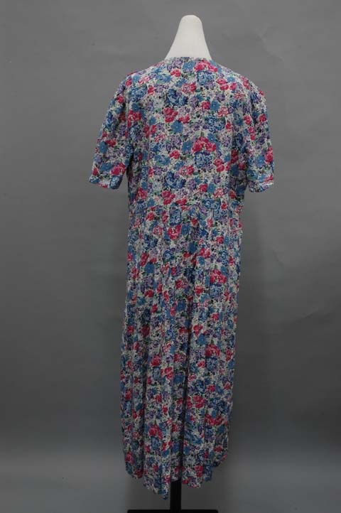
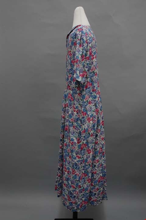
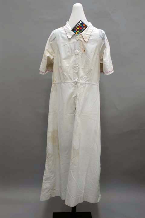
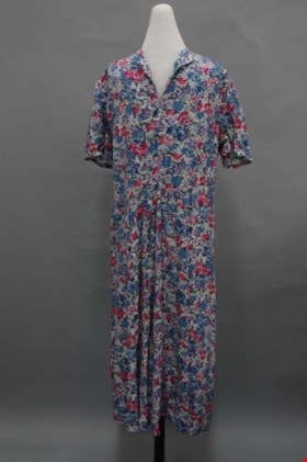
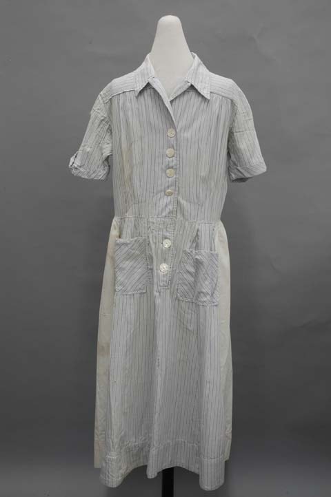
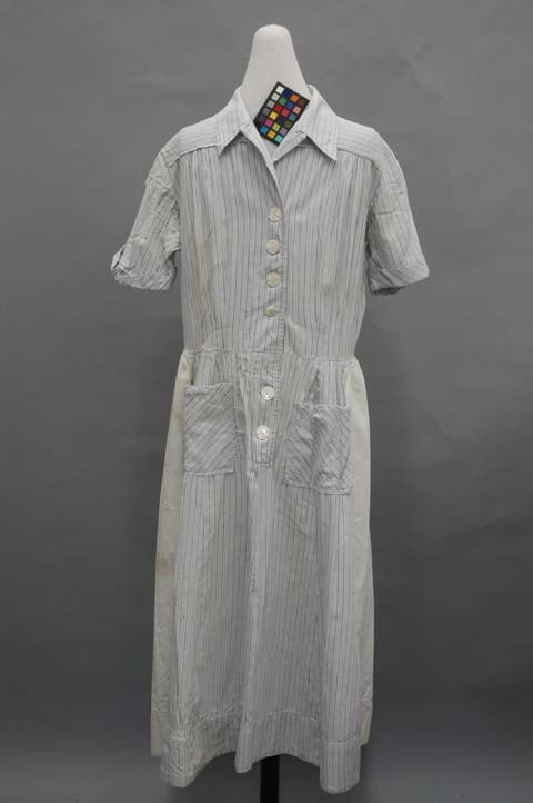
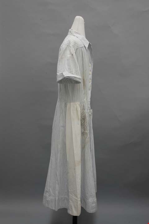
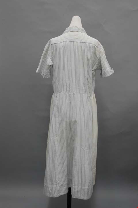
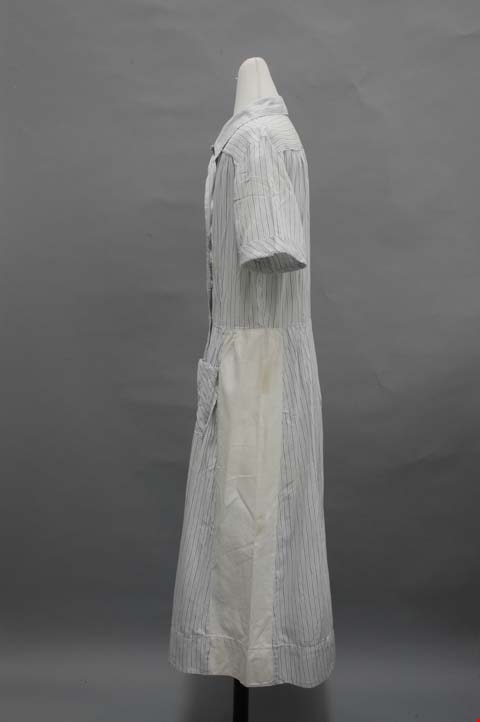
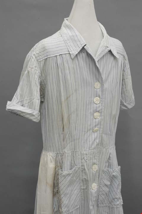
dress
https://search.heritageburnaby.ca/link/museumartifact39968
- Repository
- Burnaby Village Museum
- Accession Code
- BV999.28.7
- Description
- Dress, c.1940s. Cotton, blue pinstripes on white background. White panels up sides of flared calf length skirt, pockets, v-neck with collar, buttons centre front. The collar is on top of a square yoke that extends around the shoulders. It also has revers that extend from the turn of the bodice fabric. This creates a V neck in the 1940s style. White plastic buttons close the dress down centre front. Three pleats open up from the waist on each side front, and two on each side back. The sleeves extend up from the bottom in a kimono cut, and are constructed on the top half as set-in sleeves. The two types join in the middle, and are finished with a small cuff. The skirt has ten slightly flared gores, set into the waistband with small pleats. The side gores are made of white cotton. Down centre front, the opening continues over the hips with more buttons. On each side at hip level, there is a square patch pocket cut on the bodice. Inside the back of the neck, there is a cotton tag that has embroidered in green: "This is a Colleen Brawn Reg'n Garment / Made in Canada / 5994 34."
- Object History
- Donor inherited object from her mother and grandmother, ca. 1994.
- Maker
- Colleen Brawn
- Subjects
- Clothing
- Clothing - Costumes
- Historic Neighbourhood
- Burnaby Lake (Historic Neighbourhood)
- Planning Study Area
- Burnaby Lake Area
Images
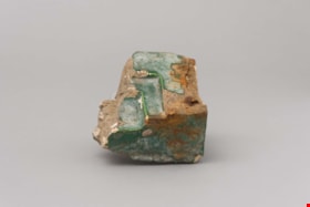
faience
https://search.heritageburnaby.ca/link/museumartifact90820
- Repository
- Burnaby Village Museum
- Accession Code
- BV020.40.11
- Description
- This is a fragment of brick or stone that was part of a fireplace hearth. A green waxy covering is present on the surfaces visible when the hearth was intact. It was three ledges or steps on one corner of the piece. There are several white markings like plaster all over the piece.
- Object History
- This is a piece of rookwood faience tile from the main floor Ceperley Mansion's fireplace before it was removed.
- Category
- 01. Built Environment Objects
- Classification
- Building Components - - Surface Elements
- Object Term
- Fireplace
- Historic Neighbourhood
- Burnaby Lake (Historic Neighbourhood)
- Planning Study Area
- Douglas-Gilpin Area
Images

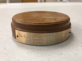
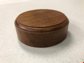
Gavel Pad
https://search.heritageburnaby.ca/link/museumartifact90815
- Repository
- Burnaby Village Museum
- Accession Code
- BV020.40.6
- Description
- Varnished and beveled wooden cylinder, used to provide a place to bang a gavel. The top surfaces is dented and scratched with use. There is a small, golden coloured metal plaque nailed into the side of the gavel pad with 2 nails. It reads "Presented to The Corporation of The District of Burnaby / Operation Identification 15-5-78 / by Burnaby Kingsway Rotary Club
- Object History
- Gavel pad used by Mayor William Copland (1987-1996). William “Bill” Copeland once joked that the reason he ran for mayor of Burnaby was because “there wasn’t a shadow of hope he would be successful” – and when the votes were tallied and he was declared victorious, Bill asked for a recount. Fortunately for the people of Burnaby, he was not serious and instead went on to become an overwhelmingly popular and much-respected leader of the community. Bill’s service to his community began early in life. Born in Vancouver on May 19, 1927, Bill was still a young man when World War Two began but that did not stop him from serving in the Merchant Marines and in the Royal Canadian Navy. After the war, Bill and his wife Ruth raised three children and in 1955 he embarked on a career with the Burnaby Fire Department. Bill went on to serve Burnaby as a firefighter until his retirement in 1987 as an Assistant Fire Chief. During this lengthy tenure, Bill held a leadership role in the Firefighters’ Union Local 323 and served as Vice President of the 6th District of the International Association of Firefighters. Over the years, Bill found various ways to contribute to the people of Burnaby. In conjunction with his work with the Fire Department, Bill was also President of the Burnaby Red Cross, Director of the Canadian National Institute for the Blind, Chairman of the St. John Ambulance, Life Member of the Burnaby North Lions Club and Member of the Deer Lake Chapter of the Rotary Club – to name but a very few of the numerous groups and organizations to which he belonged. Immediately upon his retirement from the Fire Department in 1987, Bill was asked to run for the position of Mayor of Burnaby and was successful in his bid. As Mayor, Bill earned the respect of Council and the citizens of Burnaby for his outstanding work and dedication to the community. Bill was an advocate of public participation and introduced the concept of “Area Advisory Committees” to the City with the appointment of the Hastings Street Advisory Committee. The success of this process has led to many other appointments for area advisory committees throughout Burnaby. Bill did not limit his good works to stay within the borders of the City, and as Mayor he was responsible for the two-year sister city twinning agreement with the city of El Zapotal, El Salvador. This campaign saw the citizens of Burnaby embark on numerous initiatives and fundraisers to offer support and assistance to this developing area. In 1996, Bill retired from public life after serving three terms in office and in 1997, in recognition of Bill’s contribution to the community both as a firefighter and as Mayor, the newly constructed ice arena at Burnaby Lake Sports Complex was officially named the “Bill Copeland Sports Centre,” and in 2001, Bill was made a Freeman of the City. William Copeland died August 30, 2002.
- Category
- 08. Communication Artifacts
- Classification
- Ceremonial Artifacts
- Object Term
- Gavel
- Colour
- Brown
- Gold
- Measurements
- 4 inches in diameter
- Historic Neighbourhood
- Burnaby Lake (Historic Neighbourhood)
- Planning Study Area
- Douglas-Gilpin Area
Images

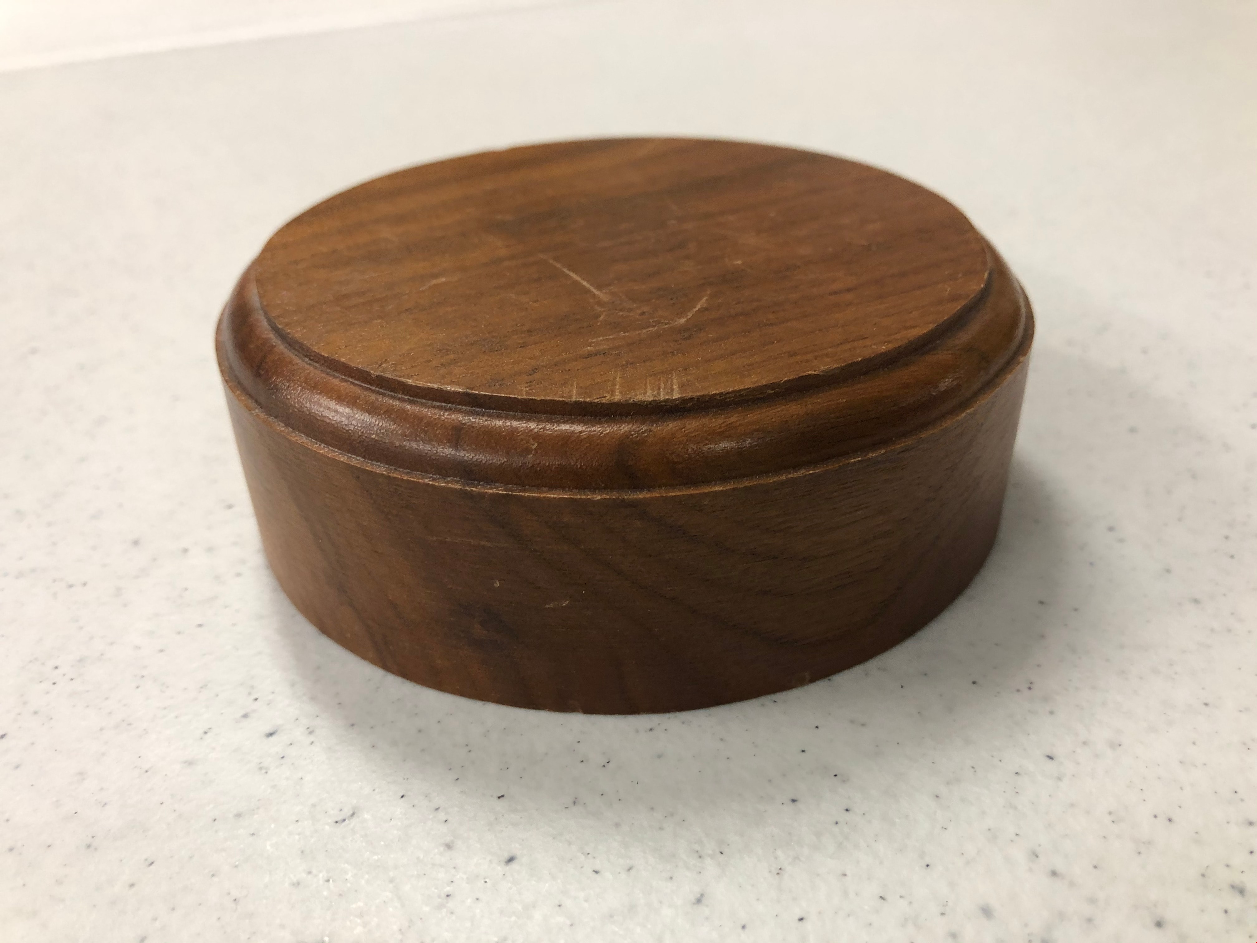
Gavel Pad
https://search.heritageburnaby.ca/link/museumartifact90816
- Repository
- Burnaby Village Museum
- Accession Code
- BV020.40.7
- Description
- Varnished and beveled wooden cylinder, used to provide a place to bang a gavel. The top surfaces is dented and scratched with use.
- Object History
- Gavel pad used by Mayor William Copland (1987-1996). William “Bill” Copeland once joked that the reason he ran for mayor of Burnaby was because “there wasn’t a shadow of hope he would be successful” – and when the votes were tallied and he was declared victorious, Bill asked for a recount. Fortunately for the people of Burnaby, he was not serious and instead went on to become an overwhelmingly popular and much-respected leader of the community. Bill’s service to his community began early in life. Born in Vancouver on May 19, 1927, Bill was still a young man when World War Two began but that did not stop him from serving in the Merchant Marines and in the Royal Canadian Navy. After the war, Bill and his wife Ruth raised three children and in 1955 he embarked on a career with the Burnaby Fire Department. Bill went on to serve Burnaby as a firefighter until his retirement in 1987 as an Assistant Fire Chief. During this lengthy tenure, Bill held a leadership role in the Firefighters’ Union Local 323 and served as Vice President of the 6th District of the International Association of Firefighters. Over the years, Bill found various ways to contribute to the people of Burnaby. In conjunction with his work with the Fire Department, Bill was also President of the Burnaby Red Cross, Director of the Canadian National Institute for the Blind, Chairman of the St. John Ambulance, Life Member of the Burnaby North Lions Club and Member of the Deer Lake Chapter of the Rotary Club – to name but a very few of the numerous groups and organizations to which he belonged. Immediately upon his retirement from the Fire Department in 1987, Bill was asked to run for the position of Mayor of Burnaby and was successful in his bid. As Mayor, Bill earned the respect of Council and the citizens of Burnaby for his outstanding work and dedication to the community. Bill was an advocate of public participation and introduced the concept of “Area Advisory Committees” to the City with the appointment of the Hastings Street Advisory Committee. The success of this process has led to many other appointments for area advisory committees throughout Burnaby. Bill did not limit his good works to stay within the borders of the City, and as Mayor he was responsible for the two-year sister city twinning agreement with the city of El Zapotal, El Salvador. This campaign saw the citizens of Burnaby embark on numerous initiatives and fundraisers to offer support and assistance to this developing area. In 1996, Bill retired from public life after serving three terms in office and in 1997, in recognition of Bill’s contribution to the community both as a firefighter and as Mayor, the newly constructed ice arena at Burnaby Lake Sports Complex was officially named the “Bill Copeland Sports Centre,” and in 2001, Bill was made a Freeman of the City. William Copeland died August 30, 2002.
- Category
- 08. Communication Artifacts
- Classification
- Ceremonial Artifacts
- Object Term
- Gavel
- Colour
- Brown
- Measurements
- 4 inches in diameter
- Historic Neighbourhood
- Burnaby Lake (Historic Neighbourhood)
- Planning Study Area
- Douglas-Gilpin Area
Images
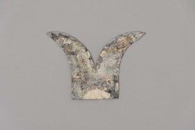
Gutter Stay
https://search.heritageburnaby.ca/link/museumartifact90822
- Repository
- Burnaby Village Museum
- Accession Code
- BV020.40.13
- Description
- Tarnished gray, brown and yellow metal piece. The base of the piece is flat with two points than curve out into opposite directions. Both points have a small hole in each tip, and one side of the base has a hole also.
- Object History
- This is a gutter stay from Hart House, used to hold the gutters in place, while being decorative.
- Category
- 01. Built Environment Objects
- Classification
- Building Components - - Plumbing & Drainage Elements
- Object Term
- Gutter
- Subjects
- Building Components
- Buildings - Heritage
- Historic Neighbourhood
- Burnaby Lake (Historic Neighbourhood)
- Planning Study Area
- Douglas-Gilpin Area
Images


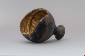
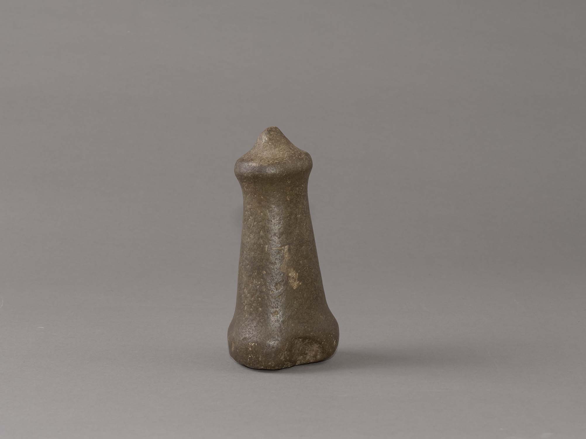
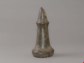
hand maul
https://search.heritageburnaby.ca/link/museumartifact44853
- Repository
- Burnaby Village Museum
- Accession Code
- BV002.57.1
- Description
- Nipple topped stone maul. It has a pointed tip and a slight indentation on side of base. There is adhesive residue on bottom of base.
- Object History
- The donor inherited this artifact from his mother, Katherine Maude (Kitty) Peers, who inherited them from her father, Louis Claude Hill. The artifacts were found on his farm, Brookfield Farm, at Douglas Road and Sperling Avenue (now site of Burnaby Village Museum). In general, hand mauls are used in woodworking todrive antler wedges or spreading sticks into logs and split planks. They were also used in combination with chisels for detail work. Their presence at an archeological site is viewed as evidence of long term habitations. They are associated with house building, canoe building, housepost and welcome figure carving. Nipple top hand mauls are identified as Marpole Culture (400 BC - 400 AD).
- Subjects
- Persons
- Indigenous peoples - British Columbia
- Woodworking Tools and Equipment
- Woodworking Tools and Equipment - Maul
- Archeological Specimen
- Historic Neighbourhood
- Burnaby Lake (Historic Neighbourhood)
Images
Documents
hand maul
https://search.heritageburnaby.ca/link/museumartifact44854
- Repository
- Burnaby Village Museum
- Accession Code
- BV002.57.2
- Description
- Conical topped stone maul; damaged by a plow.
- Object History
- The donor inherited this artifact from his mother, Katherine Maude (Kitty) Peers, who inherited them from her father, Louis Claude Hill. The artifacts were found on his farm, Brookfield Farm, at Douglas Road and Sperling Avenue (now site of Burnaby Village Museum).
- In general, hand mauls are used in woodworking todrive antler wedges or spreading sticks into logs and split planks. They were also used in combination with chisels for detail work. Their presence at an archeological site is viewed as evidence of long term habitations. They are associated with house building, canoe building, housepost and welcome figure carving. Flat and conical topped hand mauls are identified as Gulf of Georgia Culture (400 AD - 1800).
- Subjects
- Persons
- Indigenous peoples - British Columbia
- Woodworking Tools and Equipment
- Woodworking Tools and Equipment - Maul
- Archeological Specimen
- Historic Neighbourhood
- Burnaby Lake (Historic Neighbourhood)
Images
