Narrow Results By
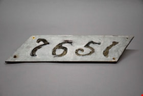
address panel
https://search.heritageburnaby.ca/link/museumartifact91313
- Repository
- Burnaby Village Museum
- Accession Code
- BV021.21.21
- Description
- The number "7651" are stenciled out across the panel, surrounded by gray paint. The panel itself is a diagonal rectangle (parallelogram) shaped sign. There are four screws, one in each corner, with two rusting screws still intact in both the bottom right and left corner. The reverse of the panel is yellowed, and was also painted gray.
- Object History
- Panel was found in the attic of Love Farmhouse August 2021, where it had been since the farmhouse restoration project in the late 1990's. This panel was an original fixture on the home.
- Category
- 08. Communication Artifacts
- Classification
- Documentary Artifacts - - Other Documents
- Object Term
- Address Label
- Colour
- Gray
- Measurements
- length: 46 cm width: 12.8 cm
- Country Made
- Canada
- Province Made
- British Columbia
- Site/City Made
- Burnaby
- Subjects
- Household Accessory
- Names
- Love Family
- Geographic Access
- Cumberland Street
- Historic Neighbourhood
- East Burnaby (Historic Neighbourhood)
Images


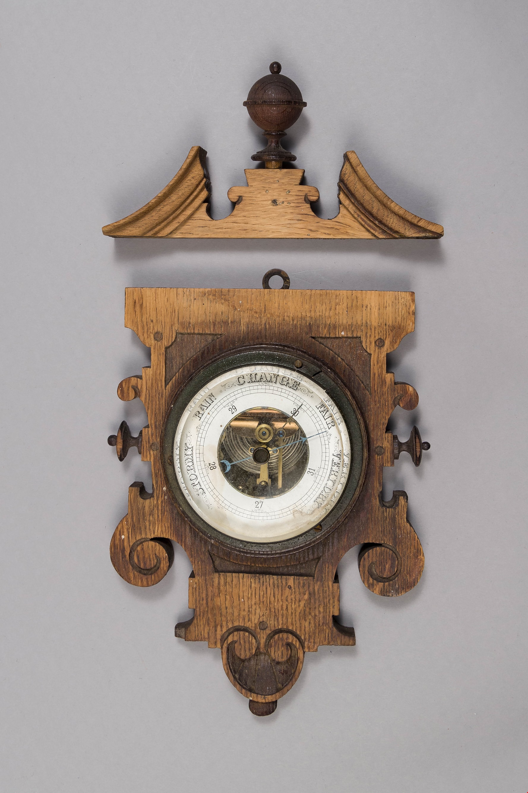
barometer
https://search.heritageburnaby.ca/link/museumartifact90178
- Repository
- Burnaby Village Museum
- Accession Code
- BV019.8.16
- Description
- barometer; aneroid barometer secured to a carved wood plaque; barometer has a calibrated dial to indicate air pressure; text on dial reads: "VERY DRY", "FAIR", "CHANGE", "RAIN", and "STORMY"; flat metal loop at top of wood plaque for hanging. Dark stained carved wood decorative scroll with finial; has detached from base plaque.
- Object History
- Object used in the Love Farmhouse, currently on site at Burnaby Village Museum.
- Geographic Access
- Cumberland Street
- Street Address
- 7651 Cumberland Street
- Historic Neighbourhood
- East Burnaby (Historic Neighbourhood)
- Planning Study Area
- Cariboo-Armstrong Area
Images
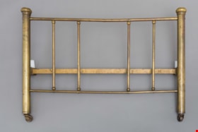
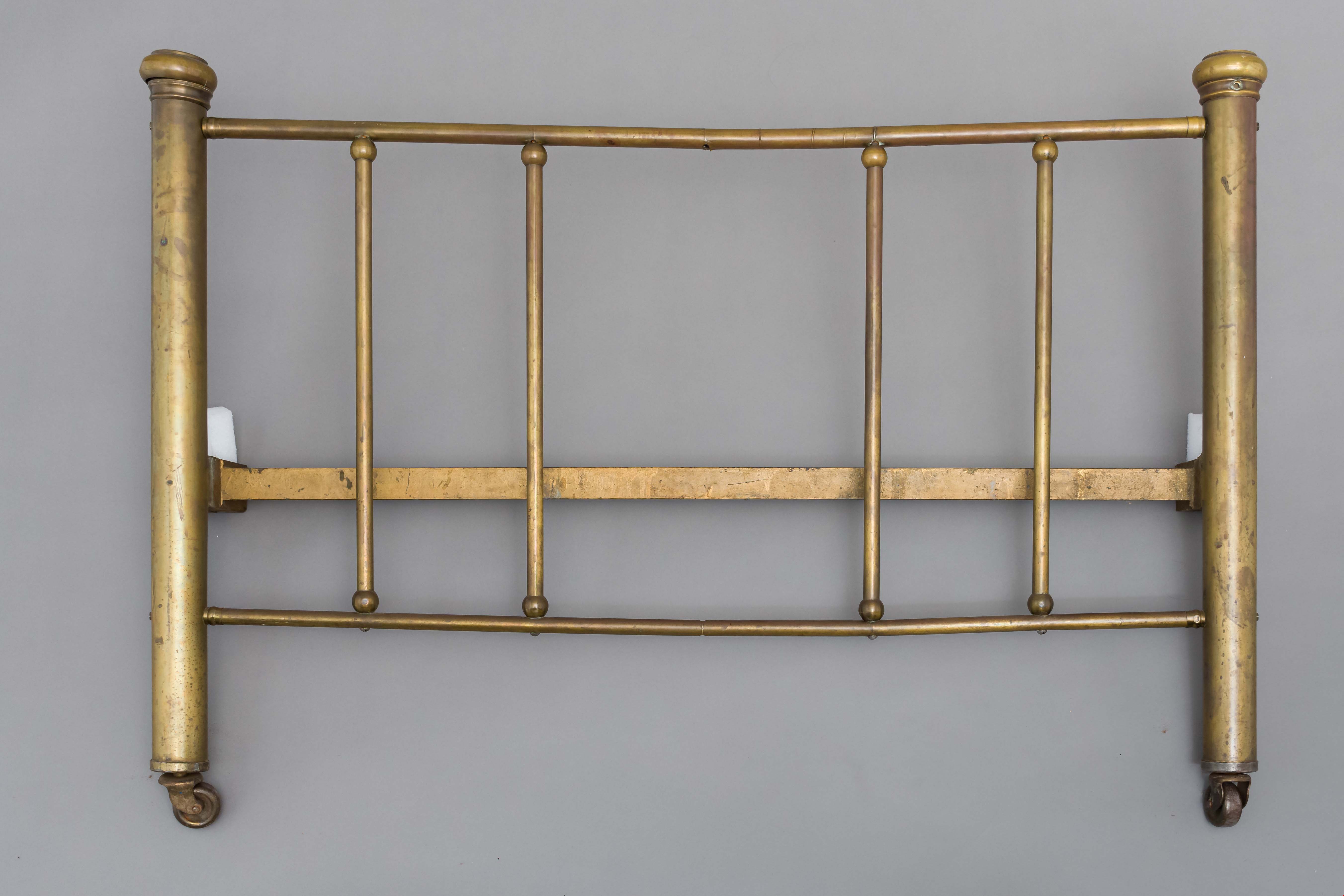
bed headboard
https://search.heritageburnaby.ca/link/museumartifact39541
- Repository
- Burnaby Village Museum
- Accession Code
- BV998.74.1
- Description
- Headboard, brass; has corner posts; on ball-bearing casters; top and bottom rails with five supporting rails; posts are 2" thick; top and bottom rails are 3/4" thick and verticals are 5/8" thick
- Object History
- The bed belonged to Leonard Love, son of Jesse and Martha Love.
- Category
- 02. Furnishings
- Classification
- Sleeping and Reclining Furniture
- Object Term
- Headboard
- Subjects
- Furniture
- Geographic Access
- Cumberland Street
- Historic Neighbourhood
- East Burnaby (Historic Neighbourhood)
- Planning Study Area
- Second Street Area
Images

building
https://search.heritageburnaby.ca/link/museumartifact3846
- Repository
- Burnaby Village Museum
- Accession Code
- BV988.33.1
- Description
- The core of the Jessie Love farm house is a 1893 two story, pioneer tent style building. The home was added to over the years and became a large Craftsmen style farm house.
- Object History
- Built on Cumberland Road in Burnaby in 1893. Music Room/Parlour/Living Room and bedrooms above added c.1898. Kitchen added c.1908. The home of Jesse and Martha Love and their eleven children. One of Burnaby's oldest structures. The home was moved to Burnaby Village Museum in the late 1980s and has been partially restored to its 1920s appearance.
- Category
- 01. Built Environment Objects
- Classification
- Structures - - Dwellings
- Object Term
- House
- Colour
- Brown
- Culture
- Canadian
- Geographic Access
- Cumberland Street
- Street Address
- 6501 Deer Lake Avenue
- Historic Neighbourhood
- East Burnaby (Historic Neighbourhood)
- Planning Study Area
- Cariboo-Armstrong Area
Images


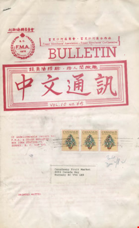
bulletin
https://search.heritageburnaby.ca/link/museumartifact91859
- Repository
- Burnaby Village Museum
- Accession Code
- BV023.25.3
- Description
- Fraser Merchants' Association - Bulletin -- [1982]. Legal sized, 15 page bulletin produced by the Fraser Merchants' Association and Fraser Merchants' Co-Operative. The bulletin is volume 10, number 65 from 1982. The document is printed in red text in both English and Chinese. The cover page has three postage stamps and the address for the Canada Way Fruit [Food] Market.
- Object History
- Item was owned by Harry Toy, proprietor of Canada Way Food market and member of the Fraser Merchants' Association. See BV023.16.19 for full biography.
- Category
- 08. Communication Artifacts
- Classification
- Documentary Artifacts - - Other Documents
- Object Term
- Serial
- Measurements
- Height: 36 cm
- Width: 22 cm
- Subjects
- Documentary Artifacts - Leaflets
- Geographic Access
- Canada Way
Images
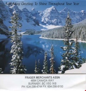
calendar
https://search.heritageburnaby.ca/link/museumartifact91860
- Repository
- Burnaby Village Museum
- Accession Code
- BV023.25.6
- Description
- Fraser Merchants' Association - Calendar -- [2001]. Calendar for 2001 circulated by the Fraser Merchants Association. The front cover of the calendar has a photograph of a lake and mountains covered in snow at Banff National Park.
- There is a page attached at the back of the calendar with the Fraser Merchants Association address, which is the same as the Canada Way Food Market.
- Object History
- Item was owned by Harry Toy, proprietor of Canada Way Food market and member of the Fraser Merchants' Association. See BV023.16.19 for full biography.
- Category
- 08. Communication Artifacts
- Classification
- Documentary Artifacts - - Other Documents
- Object Term
- Calendar
- Measurements
- Height: 22.5 cm
- Width: 21.5 cm
- Subjects
- Documentary Artifacts
- Geographic Access
- Canada Way
Images

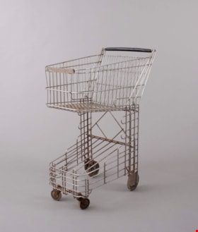
cart
https://search.heritageburnaby.ca/link/museumartifact91781
- Repository
- Burnaby Village Museum
- Accession Code
- BV023.17.1
- Description
- Small grocery or shopping cart. The cart was produced by Folding Carrier Corporation of Oklahoma. This cart is called the Nest Baskart which features a levered back panel to easily nest multiple carts together when not in use.
- The body of the cart is formed by metal spokes welded together to form a cage like pattern.
- The top of the cart has a large basket like area for holding items. The bottom of the cart has a sloped shelf that could have held another removable basket.
- The handle of the cart is covered in a hard black material, possibly hardened rubber or plastic.
- The cart features curved corners along the top and bottom of the basket area.
- The cart has four wheels, the back two are fixed and the front two are
- Object History
- Item was used in the Canada Way Food Market owned by Harry Toy between 1975 and the late 2000s. the building sat vacant until sold in 2023.
- Cart was used by donor to restock shelves when not in use by customers.
- Classification
- Merchandising T&E
- Object Term
- Cart, Shopping
- Marks/Labels
- "FOLDING CARRIER CORP. OKLAHOMA CITY, OKLA., U.S.A. / NEST BASKART, MODEL WK 1200 / PATENT NO. 2,479,530"
- Subjects
- Persons - Chinese Canadians
- Names
- Canada Way Food Market
- Geographic Access
- Canada Way
- Street Address
- 4692 Canada Way
Images
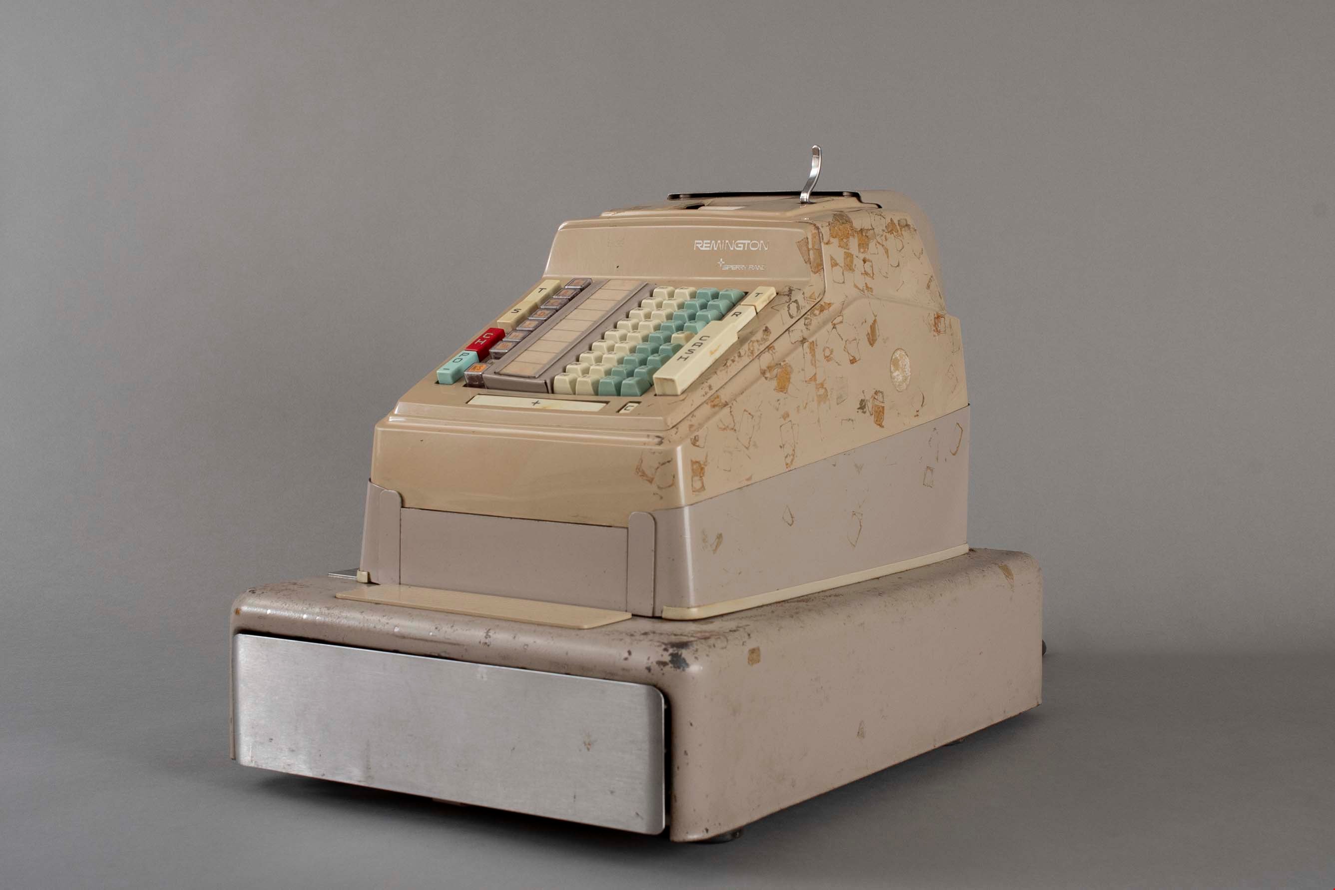
cash register
https://search.heritageburnaby.ca/link/museumartifact91785
- Repository
- Burnaby Village Museum
- Accession Code
- BV023.17.5
- Description
- Cash register, cash drawer, adding machine made by Remington Sperry Rand.
- It has four columns of keys for dollars and cents, three additional columns of digit keys, and three columns of keys with various functions on them. An addition bar and cancel button are across the base, and a paper tape at the top.
- Sales are not displayed visually by any indicator.
- There is a metal cash drawer that has plastic divisions for change and cash.
- There is a key that slots into a lock on the left side that controls the machine with a lever.
- The register is made of metal and plastic components.
- Object History
- Item was used in the Canada Way Food Market owned by Harry Toy between 1975 and the late 2000s. the building sat vacant until sold in 2023.
- Cash register was used daily in the Canada Way Food Market.
- Classification
- Merchandising T&E
- Object Term
- Register, Cash
- Maker
- Remington
- Subjects
- Persons - Chinese Canadians
- Names
- Canada Way Food Market
- Geographic Access
- Canada Way
- Street Address
- 4692 Canada Way
Images
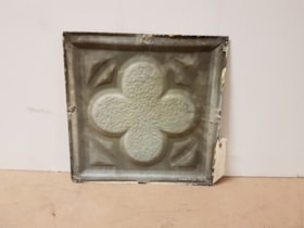
ceiling panel
https://search.heritageburnaby.ca/link/museumartifact81704
- Repository
- Burnaby Village Museum
- Accession Code
- BV988.33.109
- Description
- A single pressed metal ceiling panel with a raised four leaf clover motif. There are traces of a cream white paint at the edges. No rust.
- Object History
- This item was taken from Love farmhouse.
- Measurements
- The panel is 31.5 cm square.
- Geographic Access
- Cumberland Street
- Historic Neighbourhood
- East Burnaby (Historic Neighbourhood)
Images

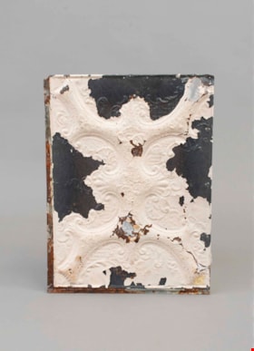
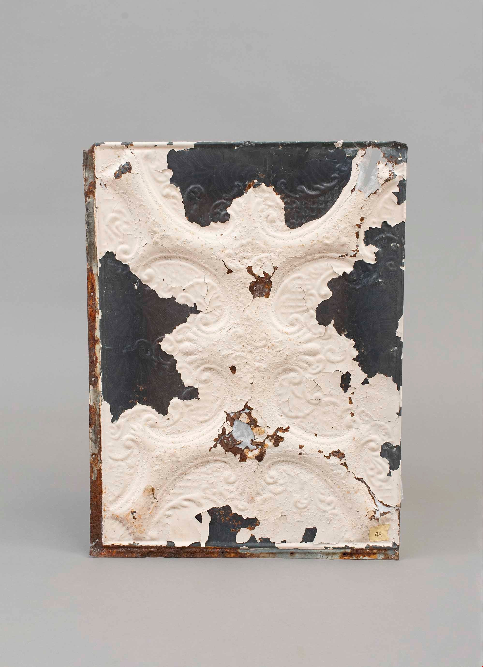
ceiling panel
https://search.heritageburnaby.ca/link/museumartifact81706
- Repository
- Burnaby Village Museum
- Accession Code
- BV988.33.111
- Description
- A single pressed metal ceiling panel with a raised scroll pattern motif. White paint is flaking from the face. There are four large areas (one on each edge) without paint. There are a number of rust holes with fiber backing as an experiment at repair There is heavy rusting on the edges and the back.
- The number "44" is written on a piece of masking tape on the face of the panel.
- Object History
- This item was taken from Love farmhouse.
- Measurements
- The panel is 45 cm X 60 cm.
- Geographic Access
- Cumberland Street
- Historic Neighbourhood
- East Burnaby (Historic Neighbourhood)
Images
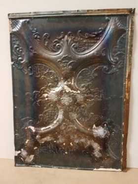
ceiling panel
https://search.heritageburnaby.ca/link/museumartifact81709
- Repository
- Burnaby Village Museum
- Accession Code
- BV988.33.114
- Description
- A single pressed metal ceiling panel with a raised scroll pattern motif(?). White paint is almost all flaked from the face. There is heavy rust on the back of the panel and fiber tape has been used to reinforce the surface.
- The number "33" is written on a piece of masking tape on the back of the panel.
- Object History
- This item was taken from Love farmhouse.
- Measurements
- The panel is 45 cm X 60 cm.
- Geographic Access
- Cumberland Street
- Historic Neighbourhood
- East Burnaby (Historic Neighbourhood)
Images

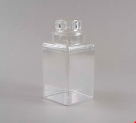
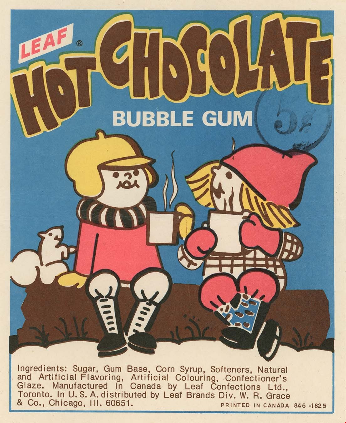
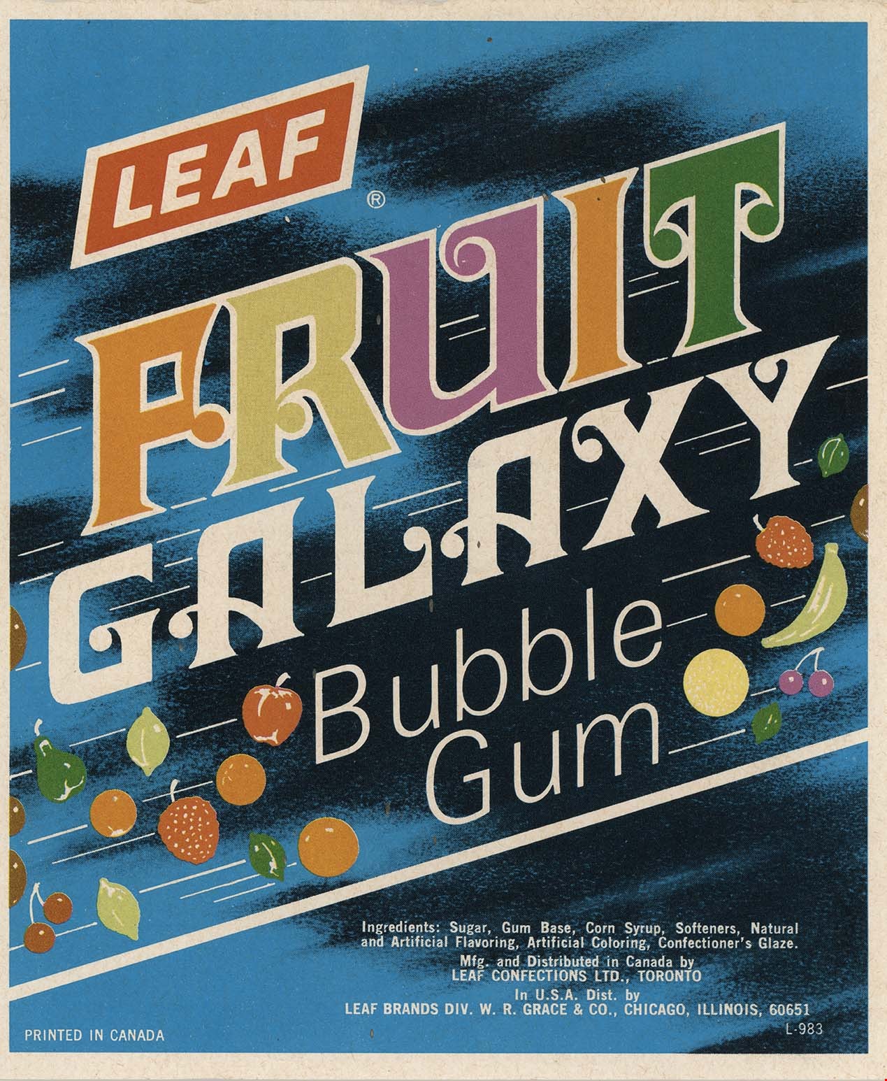
container
https://search.heritageburnaby.ca/link/museumartifact91787
- Repository
- Burnaby Village Museum
- Accession Code
- BV023.17.7
- Description
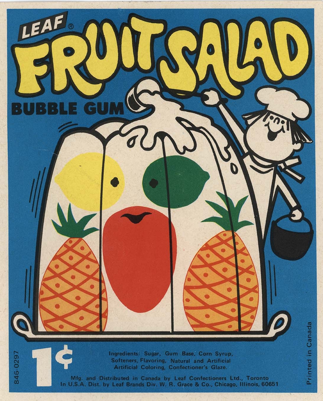
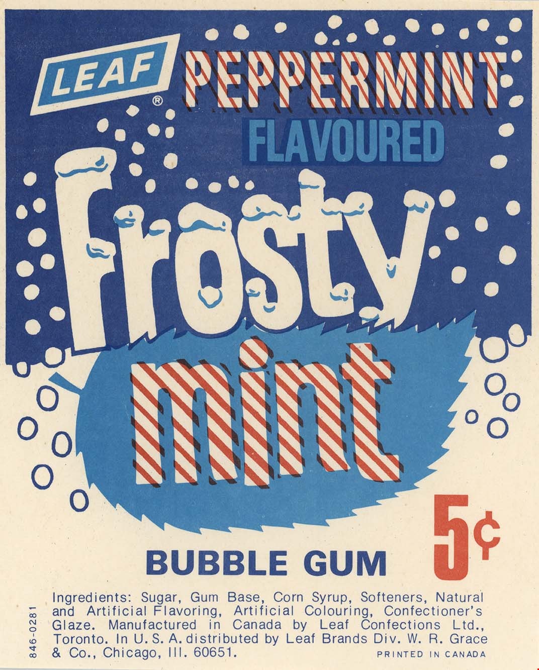
- Clear plastic containers used for selling 5 cent candy. The containers are rectangular in shape with a lid designed to look like a glass jar lid but actually opens much further down than expected.
- Inside the container was a product label advertising the type of bubble gum the container held.
- Object History
- Item was used in the Canada Way Food Market owned by Harry Toy between 1975 and the late 2000s. the building sat vacant until sold in 2023.
- Classification
- Container
- Object Term
- Canister, Food Storage
- Subjects
- Persons - Chinese Canadians
- Container
- Names
- Canada Way Food Market
- Geographic Access
- Canada Way
- Street Address
- 4692 Canada Way
Images
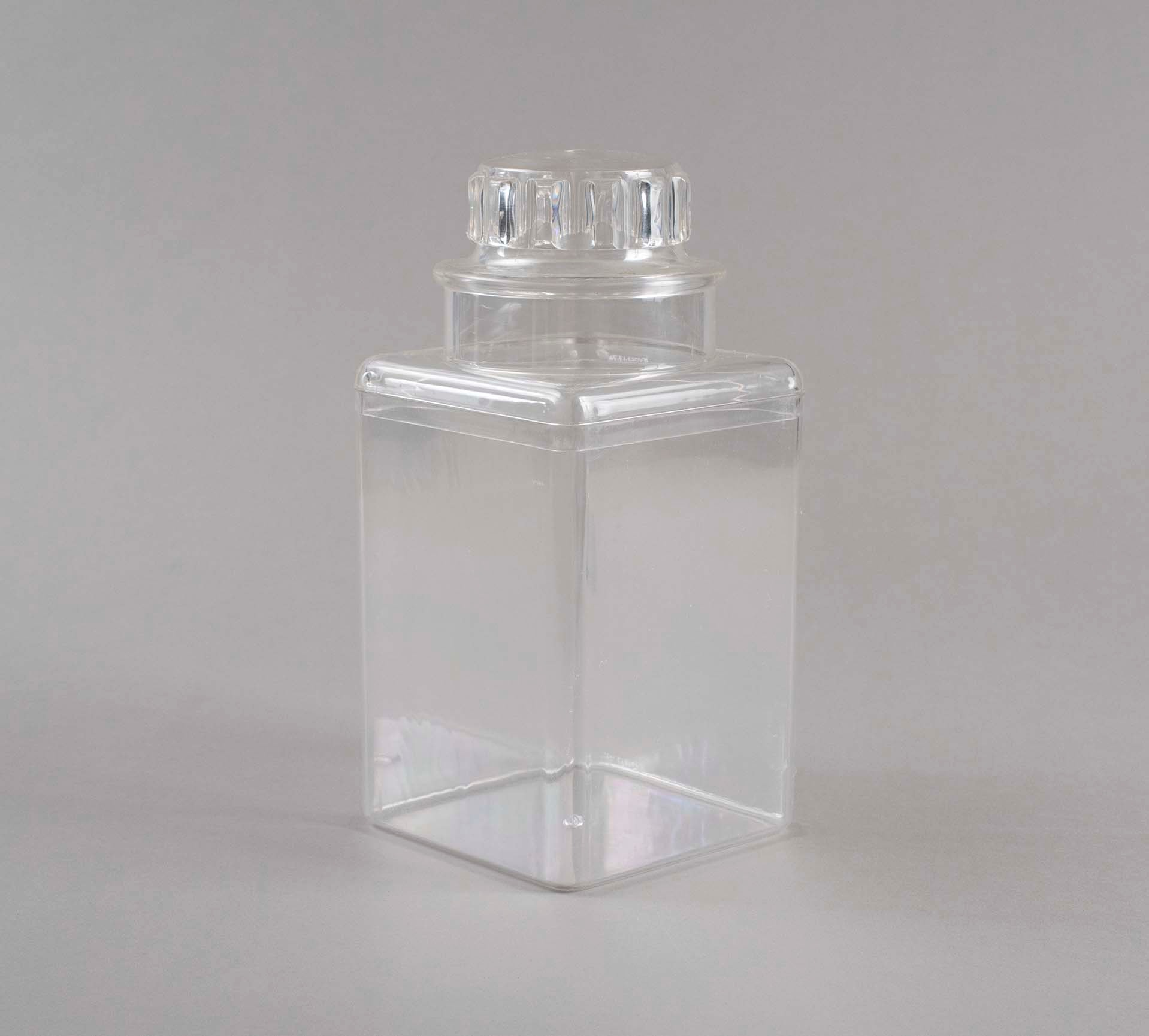
container
https://search.heritageburnaby.ca/link/museumartifact91788
- Repository
- Burnaby Village Museum
- Accession Code
- BV023.17.8
- Description
- Clear plastic containers used for selling 5 cent candy. The containers are rectangular in shape with a lid designed to look like a glass jar lid but actually opens much further down than expected.
- Inside the container was a product label advertising the type of bubble gum the container held.
- Object History
- Item was used in the Canada Way Food Market owned by Harry Toy between 1975 and the late 2000s. the building sat vacant until sold in 2023.
- Classification
- Container
- Object Term
- Canister, Food Storage
- Subjects
- Persons - Chinese Canadians
- Container
- Names
- Canada Way Food Market
- Geographic Access
- Canada Way
- Street Address
- 4692 Canada Way
Images
container
https://search.heritageburnaby.ca/link/museumartifact91789
- Repository
- Burnaby Village Museum
- Accession Code
- BV023.17.9
- Description
- Clear plastic containers used for selling 5 cent candy. The containers are rectangular in shape with a lid designed to look like a glass jar lid but actually opens much further down than expected.
- Inside the container was a product label advertising the type of bubble gum the container held.
- Object History
- Item was used in the Canada Way Food Market owned by Harry Toy between 1975 and the late 2000s. the building sat vacant until sold in 2023.
- Classification
- Container
- Object Term
- Canister, Food Storage
- Subjects
- Persons - Chinese Canadians
- Container
- Names
- Canada Way Food Market
- Geographic Access
- Canada Way
- Street Address
- 4692 Canada Way
Images
container
https://search.heritageburnaby.ca/link/museumartifact91790
- Repository
- Burnaby Village Museum
- Accession Code
- BV023.17.10
- Description
- Clear plastic containers used for selling 5 cent candy. The containers are rectangular in shape with a lid designed to look like a glass jar lid but actually opens much further down than expected.
- Inside the container was a product label advertising the type of bubble gum the container held.
- Object History
- Item was used in the Canada Way Food Market owned by Harry Toy between 1975 and the late 2000s. the building sat vacant until sold in 2023.
- Classification
- Container
- Object Term
- Canister, Food Storage
- Subjects
- Persons - Chinese Canadians
- Container
- Names
- Canada Way Food Market
- Geographic Access
- Canada Way
- Street Address
- 4692 Canada Way
Images
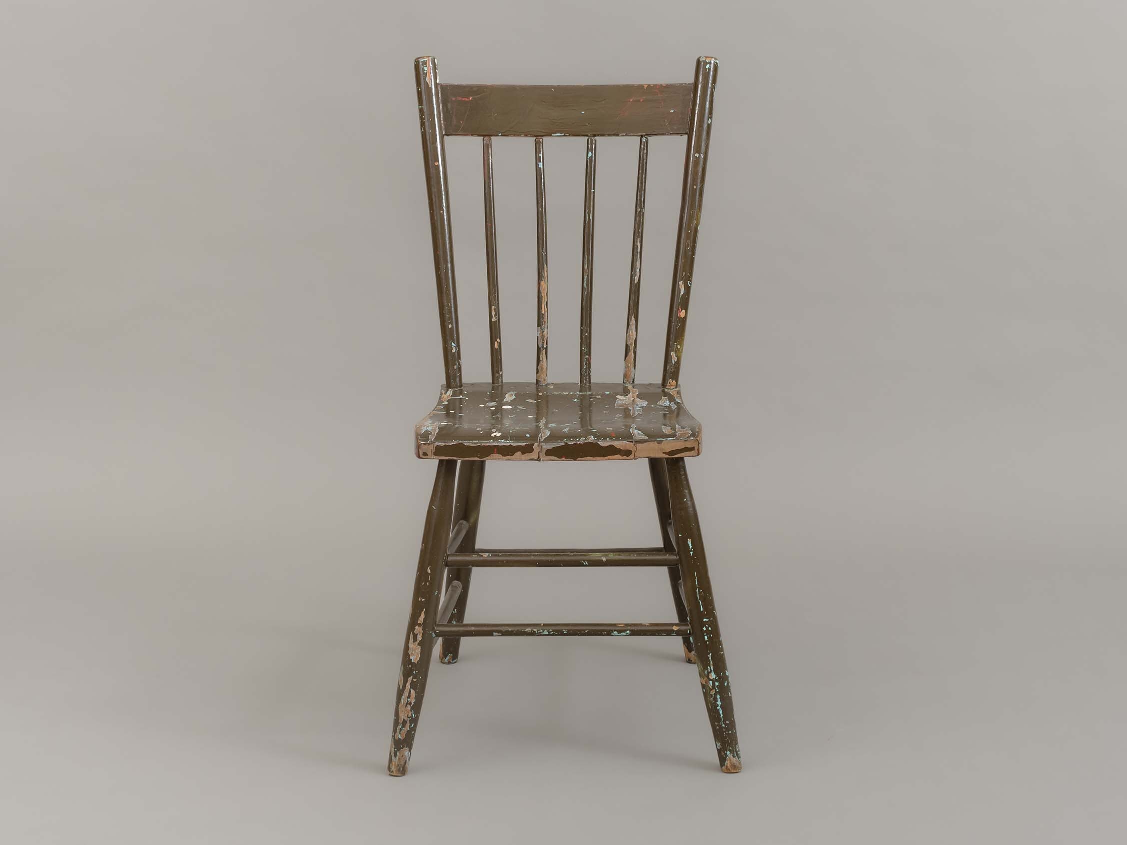
dining chair
https://search.heritageburnaby.ca/link/museumartifact90002
- Repository
- Burnaby Village Museum
- Accession Code
- BV019.8.15
- Description
- dining chair; side chair; brown painted wood; chair back has four vertical spindles; two horizontal stretchers between front and side legs; one horizontal stretcher between back legs.
- Object History
- Object used in the dining room of the Love farmhouse. The layers of paint beneath the brown outer layer reveal past colours of the chair that are documented in BVM photographs of the interior of the Love farmhouse.
- Category
- 02. Furnishings
- Classification
- Furniture - - Seating Furniture
- Object Term
- Chair
- Subjects
- Furniture
- Geographic Access
- Cumberland Street
- Street Address
- 7651 Cumberland Street
- Historic Neighbourhood
- East Burnaby (Historic Neighbourhood)
- Planning Study Area
- Cariboo-Armstrong Area
Images

Douglas Road School site
https://search.heritageburnaby.ca/link/museumdescription11136
- Repository
- Burnaby Village Museum
- Date
- April 19, 1915
- Collection/Fonds
- Ronald G. Scobbie collection
- Description Level
- Item
- Physical Description
- 1 survey plan : blueprint on paper ; 56 x 54 cm
- Scope and Content
- Survey plan of "Douglas Road School Site / Burnaby Municipality" "Being Lot 21, of Blocks 1-5 inc. 11 & 12 of the subd. of north half of Lot 80, Group 1, New Westminster District".
- Repository
- Burnaby Village Museum
- Collection/Fonds
- Ronald G. Scobbie collection
- Description Level
- Item
- Physical Description
- 1 survey plan : blueprint on paper ; 56 x 54 cm
- Material Details
- Scale 40 feet = 1 inch
- Scope and Content
- Survey plan of "Douglas Road School Site / Burnaby Municipality" "Being Lot 21, of Blocks 1-5 inc. 11 & 12 of the subd. of north half of Lot 80, Group 1, New Westminster District".
- Creator
- McGugan, Donald Johnston
- Subjects
- Buildings - Schools
- Names
- Douglas Road School
- Responsibility
- Burnett & McGugan, Engineers and Surveyors
- Geographic Access
- Canada Way
- Street Address
- 4861 Canada Way
- Accession Code
- BV003.83.15
- Access Restriction
- No restrictions
- Reproduction Restriction
- No known restrictions
- Date
- April 19, 1915
- Media Type
- Cartographic Material
- Historic Neighbourhood
- Burnaby Lake (Historic Neighbourhood)
- Planning Study Area
- Douglas-Gilpin Area
- Scan Resolution
- 440
- Scan Date
- 22-Dec-2020
- Scale
- 100
- Notes
- Title based on contents of plan
- Note in black ink on verso of plan reads: "1747"
- Oath on plan reads: "I, D.G. McGugan..." "...and did person- ally superintend the survey..." "...completed on the 3rd day of April 1915"; signed by D.J. McGugan, notarized by "H.A. Eastman", sworn "...19th day of April 1915" "Burnett and McGugan" "B.C. Land Surveyors Etc. New Westminster, B.C.."
Images

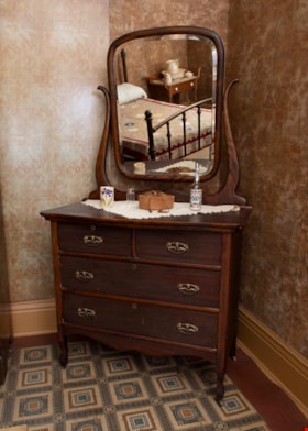
dresser
https://search.heritageburnaby.ca/link/museumartifact3362
- Repository
- Burnaby Village Museum
- Accession Code
- BV989.42.1
- Description
- Mahogany dresser C. 1920; donor plaque affixed to upper right hand drawer per curator; rectangular mirror with beveled edge is attached to curved brackets which extend up from back of dresser, can be tilted; two small drawers at top, two full-width ones below; all drawers have keyholes but plate is missing from upper right drawer
- Object History
- The mahogany dresser was donated by Gordon Love, son of John Leonard Love and also grandson of Jesse Love. The dresser was used in the Love farmhouse by Jesse's wife Martha Love. The dresser might have been part of John Leonard Love's inheritance when Jesse Love passes away. The handles on the dresser were replaced at some time with modern hardware. The hardware was replaced with more appropriate hardware for the 1920 time period. The dresser is located in the master bedroom of the Love farmhouse.
- Category
- 02. Furnishings
- Classification
- Furniture - - Storage & Display Furniture
- Object Term
- Dresser
- Subjects
- Furniture
- Geographic Access
- Cumberland Street
- Historic Neighbourhood
- East Burnaby (Historic Neighbourhood)
Images

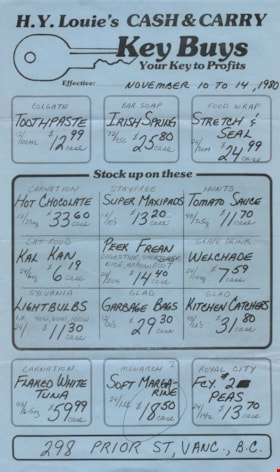
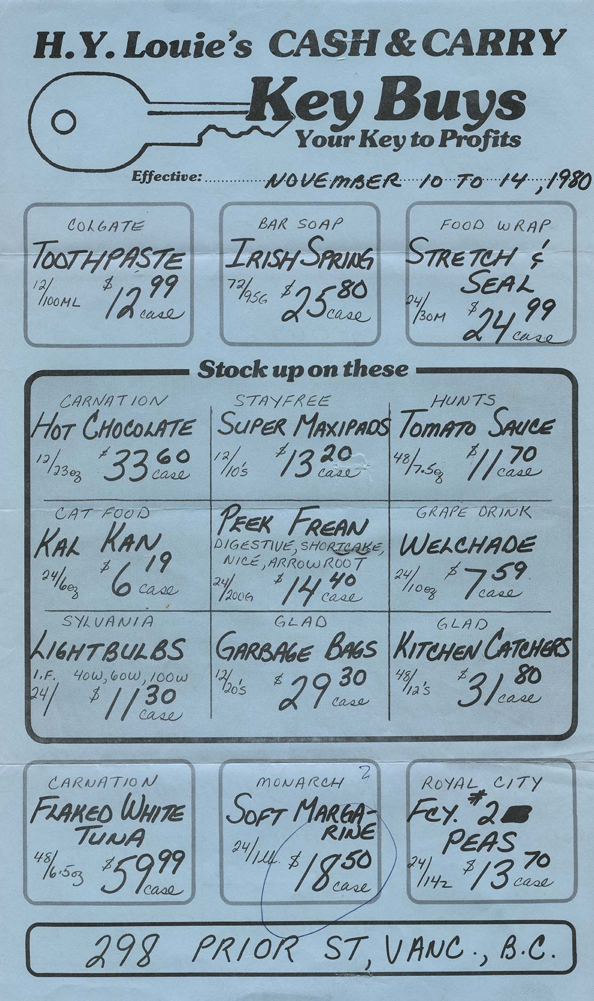
flyer
https://search.heritageburnaby.ca/link/museumartifact91861
- Repository
- Burnaby Village Museum
- Accession Code
- BV023.25.7
- Description
- H.Y. Louie's Cash & Carry - Flyer -- [1980]. Flyer or flier printed on blue legal sized paper for H.Y. Louie's Cash and Carry business. The flyer advertised different products that could be purchased and the sale price for the time period of November 10 to 14, 1980.
- The flyer was folded into four panels horizontally and stapled closed for mailing. On the back of the paper is the address for the Canada Way Market.
- Object History
- Item was owned by Harry Toy, proprietor of Canada Way Food market and member of the Fraser Merchants' Association. See BV023.16.19 for full biography.
- Category
- 08. Communication Artifacts
- Classification
- Advertising Media
- Object Term
- Flier
- Measurements
- Height: 36 cm
- Width: 22 cm
- Geographic Access
- Canada Way
Images
hinge
https://search.heritageburnaby.ca/link/museumartifact91380
- Repository
- Burnaby Village Museum
- Accession Code
- BV021.21.41
- Description
- Descorative silver coloured hinge was painted white, with three screw holes on each side.
- Object History
- This object was found in the Love Farmhouse attic in August 2021, where it had been stored since the farmhouse restoration project in the late 1990's.
- Category
- 01. Built Environment Objects
- Classification
- Building Components - - Finish Hardware
- Object Term
- Hinge
- Colour
- Silver
- Measurements
- height: 8 cm
- width: 4.5 cm
- depth: 1.5 cm
- Subjects
- Household Accessory
- Geographic Access
- Cumberland Street
- Historic Neighbourhood
- East Burnaby (Historic Neighbourhood)
Images
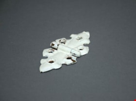
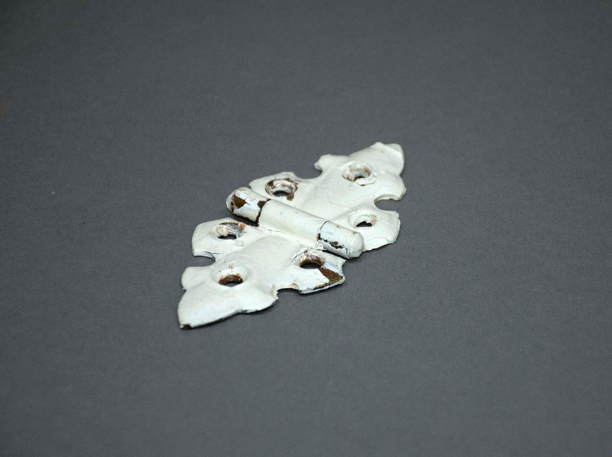
hinge
https://search.heritageburnaby.ca/link/museumartifact91383
- Repository
- Burnaby Village Museum
- Accession Code
- BV021.21.44
- Description
- Descorative brass hinge, painted white with three screw holes on each side.
- Object History
- This object was found in the Love Farmhouse attic in August 2021, where it had been stored since the farmhouse restoration project in the late 1990's.
- Category
- 01. Built Environment Objects
- Classification
- Building Components - - Finish Hardware
- Object Term
- Hinge
- Colour
- White
- Measurements
- height: 10 cm
- width: 5 cm
- depth: 1 cm
- Subjects
- Household Accessory
- Geographic Access
- Cumberland Street
- Historic Neighbourhood
- East Burnaby (Historic Neighbourhood)
Images
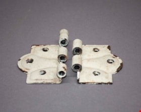
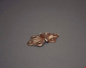
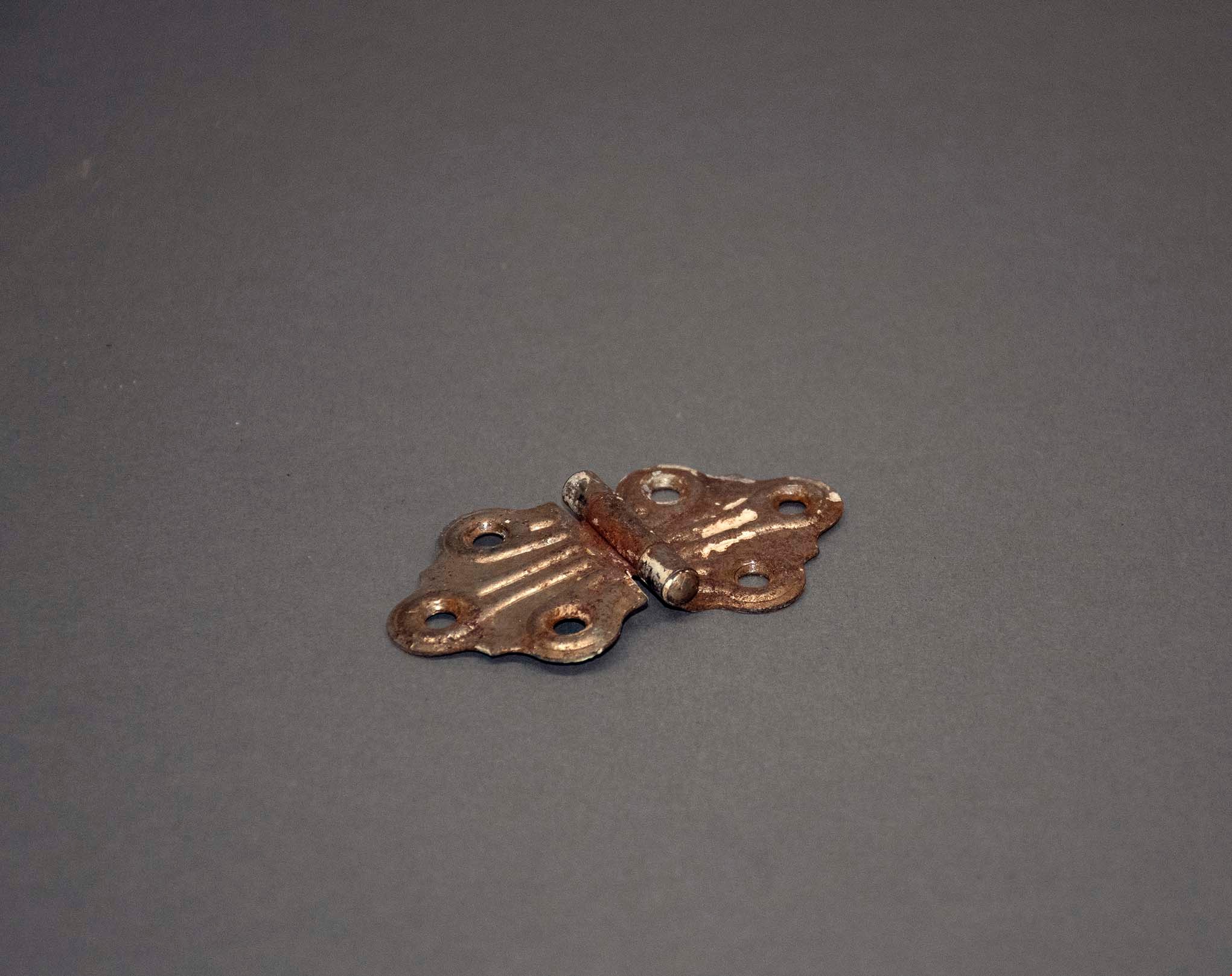
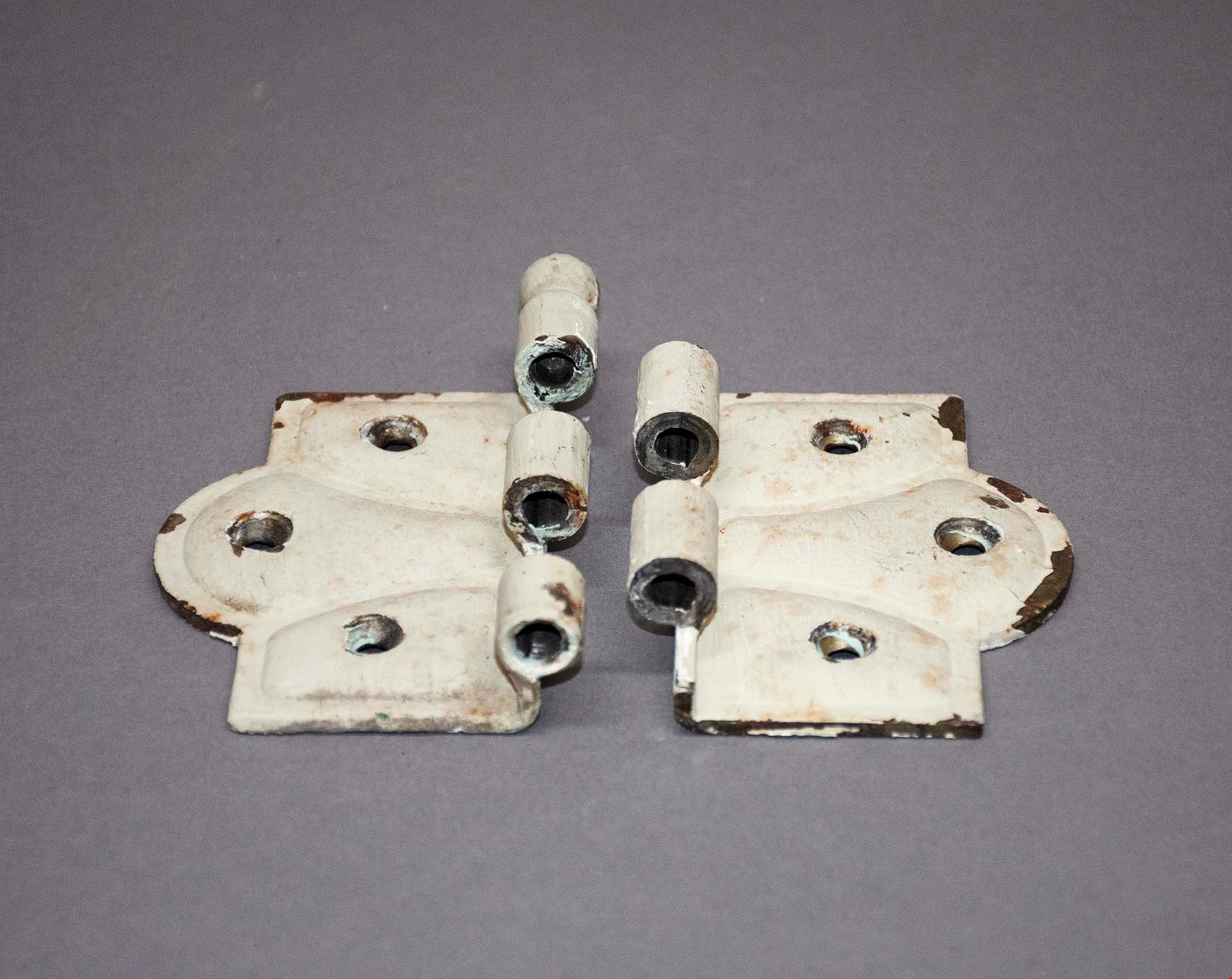
hinge set
https://search.heritageburnaby.ca/link/museumartifact91399
- Repository
- Burnaby Village Museum
- Accession Code
- BV021.21.48
- Description
- Two heavy metal decorative hinges painted cream with some blue shining through. There are three screws on each panel of the hinges.
- Object History
- This object was found in the Love Farmhouse attic August 2021, where it had been stored since the farmhouse restoration project in the late 1990's. This was likely an original piece to the home.
- Category
- 01. Built Environment Objects
- Classification
- Building Components - - Finish Hardware
- Object Term
- Hinge
- Colour
- Cream
- Subjects
- Household Accessory
- Geographic Access
- Cumberland Street
- Historic Neighbourhood
- East Burnaby (Historic Neighbourhood)
Images
linoleum
https://search.heritageburnaby.ca/link/museumartifact91422
- Repository
- Burnaby Village Museum
- Accession Code
- BV021.21.67
- Description
- Triangular piece of linoleum flooring. Pattern is blue and brown squares with white borders.
- Object History
- This object was found in the Love Farmhouse attic August 2021, where it had been stored since the farmhouse restoration project in the late 1990's. It is an original piece from the home.
- Category
- 01. Built Environment Objects
- Classification
- Building Components - - Surface Elements
- Object Term
- Linoleum
- Colour
- Blue
- Brown
- Measurements
- height: 54 cm
- width: 52.5 cm
- Subjects
- Building Components
- Geographic Access
- Cumberland Street
- Historic Neighbourhood
- East Burnaby (Historic Neighbourhood)
Images

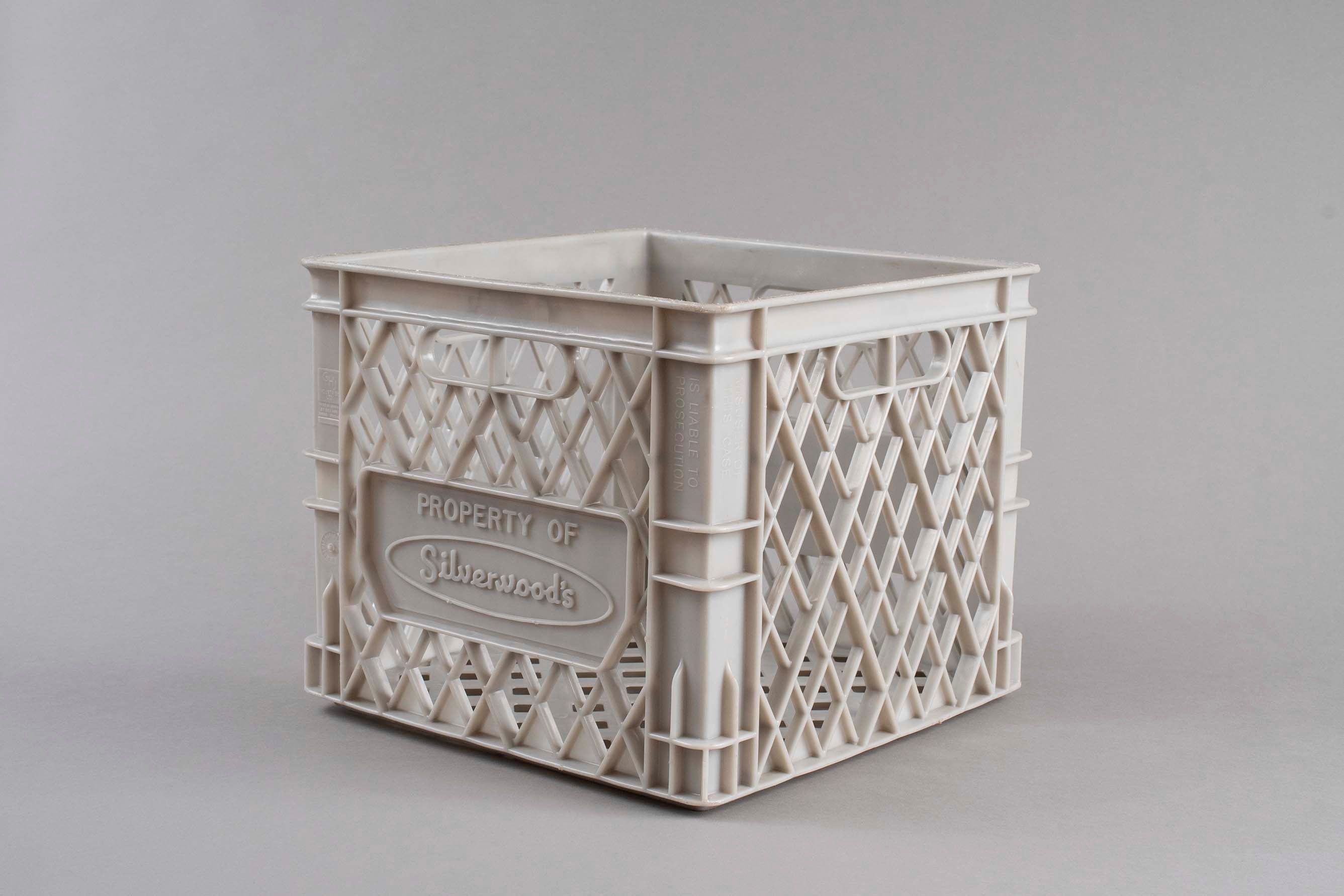
milk crate
https://search.heritageburnaby.ca/link/museumartifact91786
- Repository
- Burnaby Village Museum
- Accession Code
- BV023.17.6
- Description
- Light grey plastic milk crate produced for Silverwood's Dairy of Ontario.
- The plastic is formed in a diamond cut out pattern and has handles on two sides.
- There are various imprinted texts throughout.
- The top of the crate is scuffed an dirty
- Object History
- Item was used in the Canada Way Food Market owned by Harry Toy between 1975 and the late 2000s. the building sat vacant until sold in 2023.
- Classification
- Container
- Object Term
- Crate
- Marks/Labels
- "PROPERTY OF / SILVERWOOD'S"
- "MISUSER OF / THIS CASE / IS LIABLE TO / PROSECUTION"
- "G H J INDUSTRIES LTD / MADE IN CANADA BY GHJ IND / PATEND PENDING"
- "WARNING / USE BY OTHER THAN REGISTERED OWNER PROHIBITED BY LAW"
- Measurements
- Height: 27.5 cm
- Width: 33 cm
- Depth: 33 cm
- Subjects
- Persons - Chinese Canadians
- Container
- Names
- Canada Way Food Market
- Geographic Access
- Canada Way
- Street Address
- 4692 Canada Way
Images
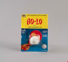
paddle ball replacement
https://search.heritageburnaby.ca/link/museumartifact91791
- Repository
- Burnaby Village Museum
- Accession Code
- BV023.17.11
- Description
- Paddle ball replacement kit including product packaging.
- The product is produced by Parker Brothers under the Bo-Lo trademark brand.
- The package is cardboard with a plastic shell containing a rubber ball and elastic band.
- The cardboard has a thick band of yellow above a gradient blue background. There is an illustration of a red Bo-Lo paddle ball.
- The back side of the package includes instructions for installing the new ball onto a paddle.
- The package is slightly damaged with creases along the cardboard and brown spotting on the back.
- Object History
- Item was used in the Canada Way Food Market owned by Harry Toy between 1975 and the late 2000s. the building sat vacant until sold in 2023.
- Category
- 09. Recreational Artifacts
- Classification
- Game Equipment
- Object Term
- Game
- Marks/Labels
- "BO-LO / BAT / RAQUETTE / REPLACEMENT KIT"
- Measurements
- Height: 14.5 cm
- Width: 10.5 cm
- Subjects
- Persons - Chinese Canadians
- Games
- Names
- Canada Way Food Market
- Geographic Access
- Canada Way
- Street Address
- 4692 Canada Way
Images

Plan of Subdivision of Block F Lot 1, D.L. 25 Group 1
https://search.heritageburnaby.ca/link/museumdescription18808
- Repository
- Burnaby Village Museum
- Date
- 17 Apr. 1912
- Collection/Fonds
- Love family fonds
- Description Level
- Item
- Physical Description
- 1 plan : black and red ink on linen ; 36 x 28.5 cm
- Scope and Content
- Item consists of Plan of Subdivision of Block F Lot 1, D.L. 25 Group 1 New Westminster District created by Provincial Land Surveyor Geoffrey K. Burnett.
- Repository
- Burnaby Village Museum
- Collection/Fonds
- Love family fonds
- Description Level
- Item
- Physical Description
- 1 plan : black and red ink on linen ; 36 x 28.5 cm
- Material Details
- Scale [1:1200]
- Scope and Content
- Item consists of Plan of Subdivision of Block F Lot 1, D.L. 25 Group 1 New Westminster District created by Provincial Land Surveyor Geoffrey K. Burnett.
- Creator
- Burnett, Geoffrey K.
- Names
- Burnett, Geoffrey K.
- Geographic Access
- Cumberland Street
- Accession Code
- BV992.26.28
- Access Restriction
- No restrictions
- Reproduction Restriction
- No known restrictions
- Date
- 17 Apr. 1912
- Media Type
- Cartographic Material
- Historic Neighbourhood
- East Burnaby (Historic Neighbourhood)
- Planning Study Area
- Cariboo-Armstrong Area
- Scan Resolution
- 600
- Scan Date
- 2022-07-11
- Scale
- 100
- Notes
- Title based on contents of item
- Scale is measured "100 FT = 1 INCH"
- "PLAN OF SUBDIVISION OF BLOCK "F" OF LOT 1, D.L. 25 GROUP 1. NEW WESTMINSTER DISTRICT"; Wright St., Sixth Ave., Fifth Ave., Cumberland St., L.1-8, 11-16; signature of Jesse Love, owner, witness S.P. King?; Geoffrey K. Burnett, P.L.S.; Fred A. Macpherson, Municipal Clerk, April 17, 1912; taxes paid to Dec. 31 1911, signed April 17 1912 by W.H. Griffin, collector"
Images


Plan of Subdivision of Block F Lot 1, D.L. 25 Group 1
https://search.heritageburnaby.ca/link/museumdescription18809
- Repository
- Burnaby Village Museum
- Date
- 17 Apr. 1912
- Collection/Fonds
- Love family fonds
- Description Level
- Item
- Physical Description
- 1 plan : black and red ink on linen ; 36 x 28.5 cm
- Scope and Content
- Item consists of Plan of Subdivision of Block F Lot 1, D.L. 25 Group 1 New Westminster District created by Provincial Land Surveyor Geoffrey K. Burnett.
- Repository
- Burnaby Village Museum
- Collection/Fonds
- Love family fonds
- Description Level
- Item
- Physical Description
- 1 plan : black and red ink on linen ; 36 x 28.5 cm
- Material Details
- Scale [1:1200]
- Scope and Content
- Item consists of Plan of Subdivision of Block F Lot 1, D.L. 25 Group 1 New Westminster District created by Provincial Land Surveyor Geoffrey K. Burnett.
- Creator
- Burnett, Geoffrey K.
- Names
- Burnett, Geoffrey K.
- Geographic Access
- Cumberland Street
- Accession Code
- BV992.26.29
- Access Restriction
- No restrictions
- Reproduction Restriction
- No known restrictions
- Date
- 17 Apr. 1912
- Media Type
- Cartographic Material
- Historic Neighbourhood
- East Burnaby (Historic Neighbourhood)
- Planning Study Area
- Cariboo-Armstrong Area
- Scan Resolution
- 600
- Scan Date
- 2022-07-11
- Scale
- 100
- Notes
- Title based on contents of item
- Scale is measured "100 FT = 1 INCH"
- "PLAN OF SUBDIVISION OF BLOCK "F" OF LOT 1, D.L. 25 GROUP 1. NEW WESTMINSTER DISTRICT"; Wright St., Sixth Ave., Fifth Ave., Cumberland St., L.1-8, 11-16; signature of Jesse Love, owner, witness S.P. King?; Geoffrey K. Burnett, P.L.S.; Fred A. Macpherson, Municipal Clerk, April 17, 1912; taxes paid to Dec. 31 1911, signed April 17 1912 by W.H. Griffin, collector"
Images


Schou Street School site
https://search.heritageburnaby.ca/link/museumdescription11138
- Repository
- Burnaby Village Museum
- Date
- April 12, 1915
- Collection/Fonds
- Ronald G. Scobbie collection
- Description Level
- Item
- Physical Description
- 1 survey plan : blueprint on paper ; 56 x 54 cm
- Scope and Content
- Survey plan of "Schou Street School Site / Burnaby Municipality" "Being Lot 1-12 inc. of Block 47, of subd. of Blocks 8-12 and 15-49 inclusive, Lot 69, Group 1" "New Westminster District";
- Repository
- Burnaby Village Museum
- Collection/Fonds
- Ronald G. Scobbie collection
- Description Level
- Item
- Physical Description
- 1 survey plan : blueprint on paper ; 56 x 54 cm
- Material Details
- Scale 40 feet = 1 inch
- Scope and Content
- Survey plan of "Schou Street School Site / Burnaby Municipality" "Being Lot 1-12 inc. of Block 47, of subd. of Blocks 8-12 and 15-49 inclusive, Lot 69, Group 1" "New Westminster District";
- Creator
- Burnett, Geoffrey K.
- Subjects
- Buildings - Schools
- Names
- Schou Street School
- Responsibility
- Burnett & McGugan, Engineers and Surveyors
- Geographic Access
- Canada Way
- Grandview Highway
- Gilmore Avenue
- Street Address
- 4054 Norfolk Street
- Accession Code
- BV003.83.17
- Access Restriction
- No restrictions
- Reproduction Restriction
- No known restrictions
- Date
- April 12, 1915
- Media Type
- Cartographic Material
- Historic Neighbourhood
- Broadview (Historic Neighbourhood)
- Planning Study Area
- Cascade-Schou Area
- Scan Resolution
- 440
- Scan Date
- 22-Dec-2020
- Scale
- 100
- Notes
- Title based on contents of plan
- Oath on plan reads: "I, Geoffrey K. Burnett...did person- ally superintend the survey..." "...completed on the 12th day of April 1915"; signed by Geoffrey K. Burnett, notarized by "S.F. Mark", sworn "..12th day.. April 1915" "Burnett and McGugan" "B.C. Land Surveyors Etc. New Westminster, B.C.
- ."handwritten on back, "1751"
- two school buildings are shown on this blueprint, "Old School Building", "New School Building"
Images

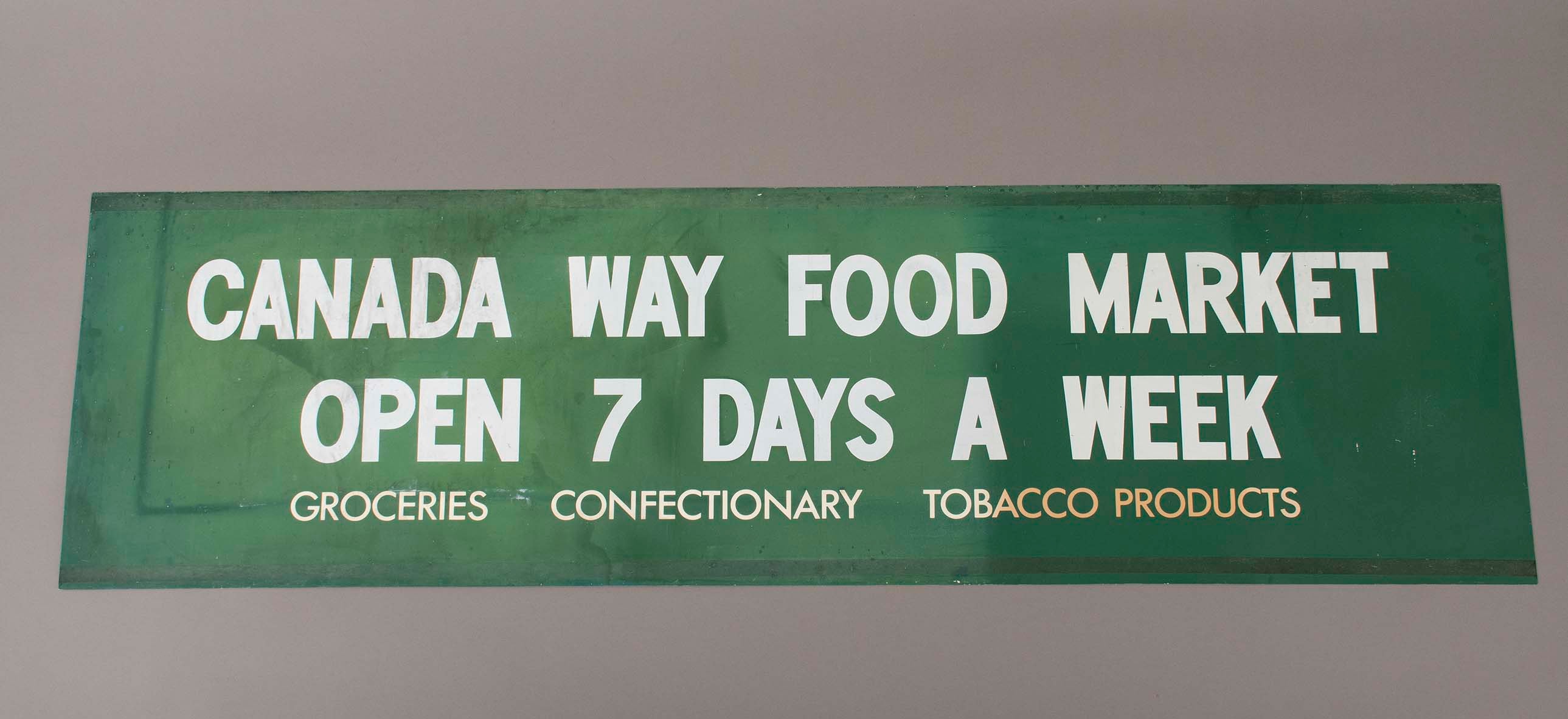
sign
https://search.heritageburnaby.ca/link/museumartifact91782
- Repository
- Burnaby Village Museum
- Accession Code
- BV023.17.2
- Description
- Green store sign from Canada Way Food Market. Plasticized green sign with white lettering.
- There is a 2.5 cm band of residue running the length of the sign at the top and bottom.
- Object History
- Item was used in the Canada Way Food Market owned by Harry Toy between 1975 and the late 2000s. the building sat vacant until sold in 2023.
- Category
- 08. Communication Artifacts
- Classification
- Advertising Media
- Object Term
- Sign, Advertising
- Marks/Labels
- "CANADA WAY FOOD MARKET / OPEN 7 DAYS A WEEK / GROCERIES CONFECTIONARY TOBACCO PRODUCTS"
- Measurements
- Height: 49.5 cm
- Width: 176.5
- Names
- Canada Way Food Market
- Geographic Access
- Canada Way
- Street Address
- 4692 Canada Way
Images
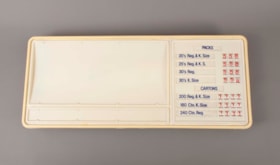
sign
https://search.heritageburnaby.ca/link/museumartifact91783
- Repository
- Burnaby Village Museum
- Accession Code
- BV023.17.3
- Description
- Large plastic sign with internal backlighting for advertising. The sign has two sections for ad inserts and one section for price display.
- The price display is currently set up advertising the price of packs and cartons of cigarettes
- The first bank of prices are 3 digit with small windows that reveal the number on a roller behind. The second bank of prices are 4 digits.
- The sign was made by CDA Industries in Scarborough, Ontario and is stamped with "JULY 1986"
- There are three labels at the top of the sign including information about how to replace the lamps or reinsert unrolled numbers.
- There is a hole at the top of the sign for the electrical cord to come out.
- There are two white metal brackets attached to the ends of the sign and there is a rusted chain hanging from each bracket.
- The plastic at the bottom right corner on the back is broken and damaged.
- Object History
- Item was used in the Canada Way Food Market owned by Harry Toy between 1975 and the late 2000s. the building sat vacant until sold in 2023.
- See BV023.25.1 for photograph of sign in situ.
- Category
- 08. Communication Artifacts
- Classification
- Advertising Media
- Object Term
- Sign, Advertising
- Marks/Labels
- "PACKS / 20's Reg. & K. Size 5.58 / 25's Reg. & K.S. 5.58 / 30's Reg. 5.58 / 30's K. Size 5.58"
- "CARTONS / 200 Reg. & K.Size 11.11 / 180 Ctn. K. Size 11.11 / 240 Ctn. Reg. 11.11"
- Measurements
- Height: 57.5 cm
- Width: 133.5 cm
- Depth: 13 cm
- Names
- Canada Way Food Market
- Geographic Access
- Canada Way
- Street Address
- 4692 Canada Way
Images
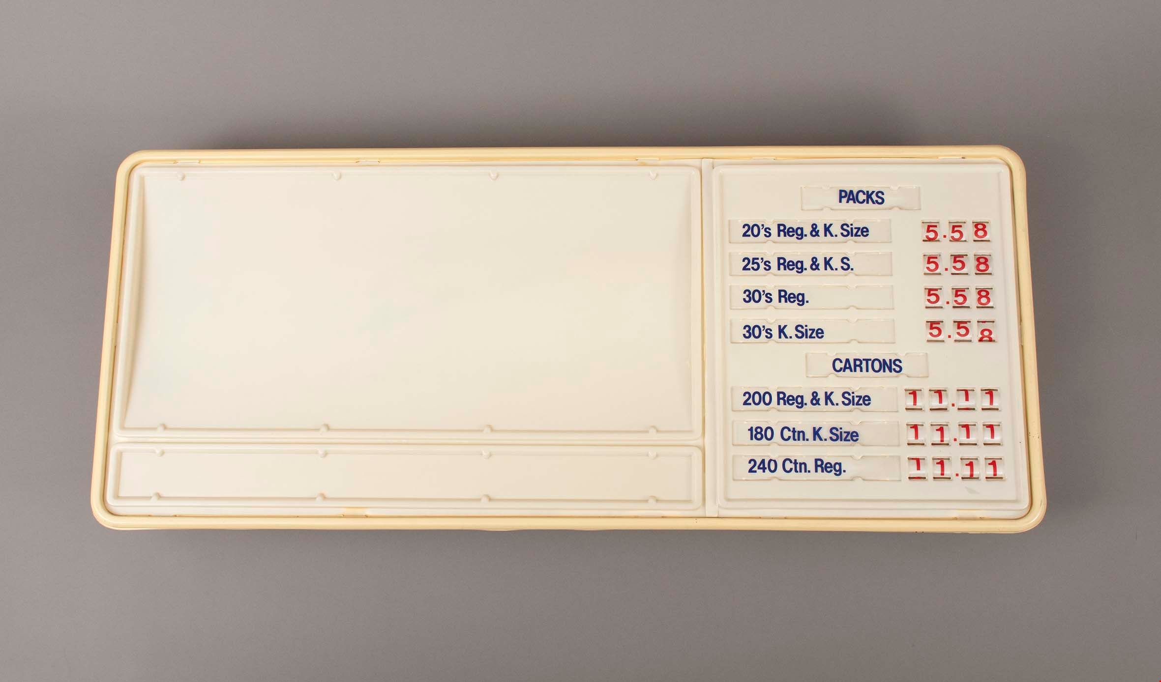
sign
https://search.heritageburnaby.ca/link/museumartifact91784
- Repository
- Burnaby Village Museum
- Accession Code
- BV023.17.4
- Description
- Wooden sandwich board advertising Dairyland products. The board consists of two wooden panels that were attached at the top with a piano hinge. The hinge is currently only attached to one panel. The wooden panels are painted white. The paint is chipping in many areas.
- Both panels feature the same information and have an large illustration of a cow's head an front body on the bottom left.
- The two panels are held together on the back with a rusty metal chain.
- Handwritten on the back of one of the panels is "Canada Way Food Market"
- Object History
- Item was used in the Canada Way Food Market owned by Harry Toy between 1975 and the late 2000s. the building sat vacant until sold in 2023.
- Category
- 08. Communication Artifacts
- Classification
- Advertising Media
- Object Term
- Sign, Advertising
- Marks/Labels
- "OPEN / Dairyland / Your / Fresh / Ideas / Dairy"
- Measurements
- Height: 74.5 cm
- Width: 49 cm
- Names
- Canada Way Food Market
- Geographic Access
- Canada Way
- Street Address
- 4692 Canada Way
Images


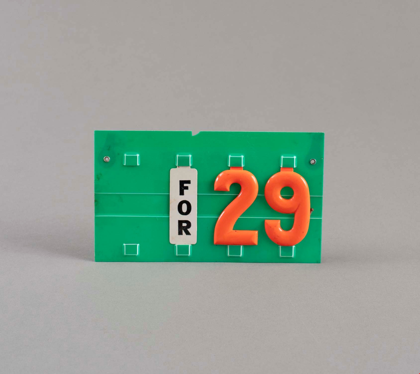
sign
https://search.heritageburnaby.ca/link/museumartifact91793
- Repository
- Burnaby Village Museum
- Accession Code
- BV023.17.13
- Description
- Green plastic price sign with slots for numbers to be placed. There are four sets of slots with three currently being used: "FOR" / "2" / "9".
- The numbers 2 and 9 are bright orange in colour.
- There are two metal hooks on the back of the sign.
- Object History
- Item was used in the Canada Way Food Market owned by Harry Toy between 1975 and the late 2000s. the building sat vacant until sold in 2023.
- Category
- 08. Communication Artifacts
- Classification
- Advertising Media
- Object Term
- Sign
- Measurements
- Height: 9 cm
- Width: 15 cm
- Subjects
- Persons - Chinese Canadians
- Names
- Canada Way Food Market
- Geographic Access
- Canada Way
- Street Address
- 4692 Canada Way
Images
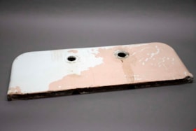
sink backsplash
https://search.heritageburnaby.ca/link/museumartifact91424
- Repository
- Burnaby Village Museum
- Accession Code
- BV021.21.65
- Description
- Rectangular piece of white metal painted pink, with curved edges at the top and two openings centre-top where faucets would sit.
- Object History
- Object was found in the Love Farmhouse attic August 2021, where it had been stored since the farmhouse restoration project in the late 1990's. This object is an original piece from the home.
- Category
- 01. Built Environment Objects
- Classification
- Building Components - - Surface Elements
- Object Term
- Backsplash
- Colour
- White
- Pink
- Measurements
- height: 73 cm
- width: 29 cm
- depth: 3.5 cm
- Subjects
- Building Components
- Geographic Access
- Cumberland Street
- Historic Neighbourhood
- East Burnaby (Historic Neighbourhood)
Images

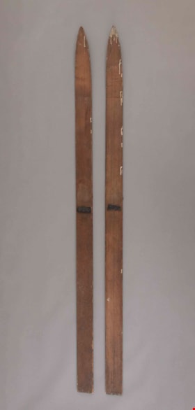
skis
https://search.heritageburnaby.ca/link/museumartifact36910
- Repository
- Burnaby Village Museum
- Accession Code
- BV988.33.22
- Description
- Home made skis made by William Parker. The original leather bindings are mostly gone, only one broken, dark coloured leather strap remains.
- Object History
- The skis were found in the Jesse Love farmhouse when moved to the Museum. The skis were hand made by Bill Parker, grandson of Jesse Love and son of Sarah Parker (Love) and William Parker. He made them while living in the Love farmhouse as a young man. He often did woodworking in the kitchen, after the bath tub was moved upstairs and before the kitchen was remodeled. When he was older his woodwork projects were done in the wood working shed outside. The skis were originally flat, but he found they did not work well. After observing people on store bought skis, he tried to steam the wood and weigh down the ends to get the tips of the skis to curve. He use the skis to around the yard and down the hill of Cumberland St. Bill later used the skis as a young adult while courting his wife. The skis were stored in the house and forgotten.
- A pair of skis in one corner of the farmhouse kitchen are visible in photographs of the kitchen taken in the early 1970.
- Maker
- Bill Parker
- Country Made
- Canada
- Province Made
- British Columbia
- Site/City Made
- Jesse Love Farmhouse
- Subjects
- Recreational Activities
- Geographic Access
- Cumberland Street
- Historic Neighbourhood
- East Burnaby (Historic Neighbourhood)
Images

![Survey and Subdivision plans in New Westminster District Group 1 – Burnaby
, [1908] thumbnail](/media/hpo/_Data/_BVM_Cartographic_Material/1977/1977_0093_0004a_001.jpg?width=280)
Survey and Subdivision plans in New Westminster District Group 1 – Burnaby
https://search.heritageburnaby.ca/link/museumdescription6973
- Repository
- Burnaby Village Museum
- Date
- [1908]
- Collection/Fonds
- Burnaby Village Museum Map collection
- Description Level
- File
- Physical Description
- 10 plans : blueprint ink on paper mounted on 2 sides of cardboard ; 76 cm x 102 cm
- Scope and Content
- Item consists of a large board of four New Westminster District Gp 1 - subdivision plans mounted on one side and six New Westminster District Gp 1 - subdivision plans mounted on the other side. Side A: 1. Blueprint "Plan / of - ReSubdivision / of / Lots 1-18 inclusive / Blocks 20 and 21 / in Sub…
- Repository
- Burnaby Village Museum
- Collection/Fonds
- Burnaby Village Museum Map collection
- Description Level
- File
- Physical Description
- 10 plans : blueprint ink on paper mounted on 2 sides of cardboard ; 76 cm x 102 cm
- Material Details
- Scales [between 1:792 and 1:4752]
- Index number on edge of board reads: "4"
- Scope and Content
- Item consists of a large board of four New Westminster District Gp 1 - subdivision plans mounted on one side and six New Westminster District Gp 1 - subdivision plans mounted on the other side. Side A: 1. Blueprint "Plan / of - ReSubdivision / of / Lots 1-18 inclusive / Blocks 20 and 21 / in Subdivision / of / Lot 53 -Gr.1 / New Westminster District" / "Subdivision Lot Numbers - Shown in Red". Plan is bordered by First Street / Jorgenson's Line / Fourth Avenue and Second Street with Fifith Avenue running through the centre. There is an index in the upper right corner of the plan. Planned is signed by "Peter Byrne" and "William R. Phillips" and dated July 28, 1908. (Geographic location: Burnaby) 2. Blueprint "Plan / of Subdivision / of / Lot 159 / and a Portion of Lot 158 / Group One / New Westminster District". Plan is bordered by Lots 96 and 97; South Wilson Street; North Arm Road and Lot 160 / Power House Road (Lot 155 A). B.C.E.R. Gilley Station is identified in the upper right corner of the plan. (Geographic location: Burnaby) 3. Blueprint plan identified as "Subdvs 10, L 88 and Lot 25, G. 1" Plan identifies Cumberland Street running from top to the bottom and a Ravine running alongside with the Jensen house, stable and barn. (Geographic location: Burnaby) 4. Blueprint Plan of "Lot 153. G. 1 /New Westminster District". Plan identifies the "New Westminster & Vancouver Tramway" and the "New Westminster and Vancouver Road" running through the plan of Lot 53. (Geographic location: Burnaby) Side B: 1. Blueprint plan of "Profile on Proposed North Rd. Diversion". 2. Blueprint plan (no title) showing wood lots north of Burnaby Lake and Brunette River and west of North Road. Various lots are identified as "Heavily Timbered" (Lot 57); "Splendid Fir and Cedar / Heavy Fir etc. / Fine Cedar" (Lots 143, 148); "Rough Light Timber," (Lot 56); "Some Fir and Cedar" (Lot 40). (Geographic location: Burnaby) 3. Blueprint "Plan / of Subdivision / of a Portion / of Lot 87, Gr.1 / New Westminster District". Plan is bordered by Burnaby Lake at the top and Hastings Road / Lot 86 at the bottom and Lot 90 to the east. "Albert J. Hill B.C.LotS." Annotation in ink reads: " J.A. Brownlee, B.C.L.S. / Subdivision / Map 1494 / Bd. 248". Plan is signed by "Peter Byrne, Reeve" (Geographic location: Burnaby) 4. Blueprint plan of Subdivisions along either side of Douglas Road including Lots 117; 119; 74; 80; 79 and 77. (Geographic location: Burnaby) 5. Blueprint "Plan / of / Subdivision of / Lot 27 / in Subdivision / of / Lot 30 / Group One / New Westminster District" Plan is bordered by Lot 26, Lot 28 and Hastings Rd. Lot 27 runs north of Edmonds Street. , "Albert J. Hill, B.C.LotS." (Geographic location: Burnaby) 6. Blueprint plan identified as a "Cultivated Orchard" including the names "W. Grace" and "G. Mead" located north of the North Arm Fraser River and west of "Twentieth Street_ City Boundary". Handwritten annotation in coloured pencil reads: "Portion of Lot 172" (Geographic location: Burnaby)
- Subjects
- Geographic Features - Forests
- Geographic Access
- Cumberland Street
- North Road
- Hastings Street
- Douglas Road
- Accession Code
- HV977.93.4
- Access Restriction
- No restrictions
- Reproduction Restriction
- No known restrictions
- Date
- [1908]
- Media Type
- Cartographic Material
- Historic Neighbourhood
- Burnaby Lake (Historic Neighbourhood)
- Fraser Arm (Historic Neighbourhood)
- Planning Study Area
- Douglas-Gilpin Area
- Burnaby Lake Area
- Scan Resolution
- 300
- Scale
- 72
- Notes
- Title based on contents of file
- Scale is measured in chains. (One chain equals 792 inches)
- The term "Lot" can also refer to a "District Lot”-
Images
![Survey and Subdivision plans in New Westminster District Group 1 – Burnaby
, [1908] thumbnail](/media/hpo/_Data/_BVM_Cartographic_Material/1977/1977_0093_0004a_001.jpg)

![Survey and Subdivision plans in New Westminster District Group 1 – Burnaby, [1905-1917] thumbnail](/media/hpo/_Data/_BVM_Cartographic_Material/1977/1977_0093_0022a_001.jpg?width=280)
Survey and Subdivision plans in New Westminster District Group 1 – Burnaby
https://search.heritageburnaby.ca/link/museumdescription6991
- Repository
- Burnaby Village Museum
- Date
- [1905-1917]
- Collection/Fonds
- Burnaby Village Museum Map collection
- Description Level
- File
- Physical Description
- 12 plans : 6 black ink on paper + 2 black & col. ink on paper + 4 graphite on paper
- Scope and Content
- Item consists of a large board of six New Westminster District subdivision plans mounted on one side and six New Westminster District subdivision plans mounted on the other side. Side A: 1. Plan drawn in graphite with markings in black ink "Surveyed for Mr. W. Wilson / Paterson Stat. B.C.E.R." . …
- Repository
- Burnaby Village Museum
- Collection/Fonds
- Burnaby Village Museum Map collection
- Description Level
- File
- Physical Description
- 12 plans : 6 black ink on paper + 2 black & col. ink on paper + 4 graphite on paper
- Material Details
- Scales [between 1:360 and 1:3168]
- Index number on edge of board reads: "22"
- Scope and Content
- Item consists of a large board of six New Westminster District subdivision plans mounted on one side and six New Westminster District subdivision plans mounted on the other side. Side A: 1. Plan drawn in graphite with markings in black ink "Surveyed for Mr. W. Wilson / Paterson Stat. B.C.E.R." . Plan includes subdivision of lots situated between B.C.E. Railway and Vancouver Road (Kingsway). (Geographic location: Burnaby) 2. Subdivision plan (no title) drawn in black ink with annotations in graphite. Plan covers District Lots 2, 4 and 6, west of North Road. Plan is stamped: "Albert J. Hill, Civil Engineer / and / Provincial Land Surveyor, / New Westminster, / B.C. (Geographic location: Burnaby) 3. Plan of "Portion of Municipality" with intials "RB" [sic] (handwritten in blue crayon). Plan covers the area north east of the City of New Westminster including District Lots 11, 13, 14, 12, 1 and 2. Plan is stamped: "Albert J. Hill, Civil Engineer / and / Provincial Land Surveyor, / New Westminster, / B.C. (Geographic location: Burnaby) 4."Plan / of Subdivision of / N.W.1/4 Lot 175 / Group 1 New West. Dist. / B.C. / Scale 4 chs = 1 in. " Plan is stamped: "Albert J. Hill, Civil Engineer / and / Provincial Land Surveyor, / New Westminster, / B.C. and initialed : "RB" [sic] (in blue pencil crayon) (Geographic location: Burnaby) 5. "Subdivision / of a Portion of / Lot 15 Group 1 / New Westminster Dist. / Scale 4 chs = 1 in". Plan provides numbered sudivisions - Lots 1 to 15 of District Lot 15 in red ink. (Geographic location: Burnaby) 6. Plan of "Central Park & / Vicinity" Plan includes subdivisions of District Lot 153 east of Central Park District Lot 151 and subdivision of District Lot 36 and 49 west of Boundary Road (Vancouver). Plan is stamped: "Albert J. Hill, Civil Engineer / and / Provincial Land Surveyor, / New Westminster, / B.C. and initialed : "RB" [sic] (in blue pencil crayon). (Geographic location: Burnaby) Side B: 1. Subdivision plan (no title) drawn in black ink. Plan identifies lots between Vancouver Road (Yale Road is crossed out and replaced with Vancouver Road) and B.C.E. Railway. "Scale 2 chs = 1 in" (Geographic location: Burnaby) 2. Plan of "Subdivision Lot 1 / Lot 69 Gr. 1 / Scale 30' = 1 " " Plan identifies Boundary Road, Still Creek and a Road Allowance between District Lot 118 and District Lot 69. Plan was "Surveyed for Burnaby Mun. Council / March 11th 1908 / G.K.B." (Geographic location: Burnaby) 3. Plan drawn in black ink (no title) showing a subdivision in Lot 25 with names "Newcomb", "Debeck" and "Armstrong" along with roads identified as Third Street, Cumberland Street, Armstrong Street and Cariboo [sic] Street and including Lots 27, 11 and 13.Plan is stamped: "Albert J. Hill, Civil Engineer / and / Provincial Land Surveyor, / New Westminster, / B.C. and initialed : "RB" [sic] (in blue pencil crayon). (Geographic location: Burnaby) 4. Handrawn subdivision plan in graphite titled: "Lot 13, Gr.1" with intials "RB" [sic] (handwritten in blue crayon). Plan is bordered by Armstrong Street (Lot 11, G.1), Cumberland St. (Lot 25, G.1) and Tenth Avenue (City Boundary). The plan is singed by "Albert J. Hill / P.L.S." and one of the subdivided lots is identified with the name: "W. Karrymann". (Geographic location: Burnaby) 5. Handrawn sketch in graphite titled: "Lot 88, Gr.1" with intials "RB" [sic] (handwritten in blue crayon). Plan appears to be a draft of a subdivision plan of a portion of District Lot 88 along Cumberland Road. The plan is signed: "16/7/17 _W.F. Draper [sic] / B.C.L.S." (Geographic location: Burnaby) 6. "Plan / of Subdivision / of Blocks 61, 62 and 2 / Lot 30 / Group 1 / N.W. Dist. / Scale 1ch = 1 in". Plan is intialed by: "PB" with a note: "Also see board 2 / for duplicate" (handwritten in blue crayon). (Geographic location: Burnaby)
- Creator
- Hill, Albert James
- Geographic Access
- Boundary Road
- Kingsway
- Cumberland Street
- Accession Code
- HV977.93.22
- Access Restriction
- No restrictions
- Reproduction Restriction
- No known restrictions
- Date
- [1905-1917]
- Media Type
- Cartographic Material
- Historic Neighbourhood
- Central Park (Historic Neighbourhood)
- Scan Resolution
- 300
- Scale
- 100
- Notes
- Title based on contents of file
- Scale is measured in chains and feet. (One chain equals 792 inches)
- The term "Lot" can also refer to a "District Lot”
- Some plans are stamped: "Albert J. Hill, Civil Engineer / and / Provincial Land Surveyor, / New Westminster, / B.C." and intialed: "RB" [sic]
Images
![Survey and Subdivision plans in New Westminster District Group 1 – Burnaby, [1905-1917] thumbnail](/media/hpo/_Data/_BVM_Cartographic_Material/1977/1977_0093_0022a_001.jpg)


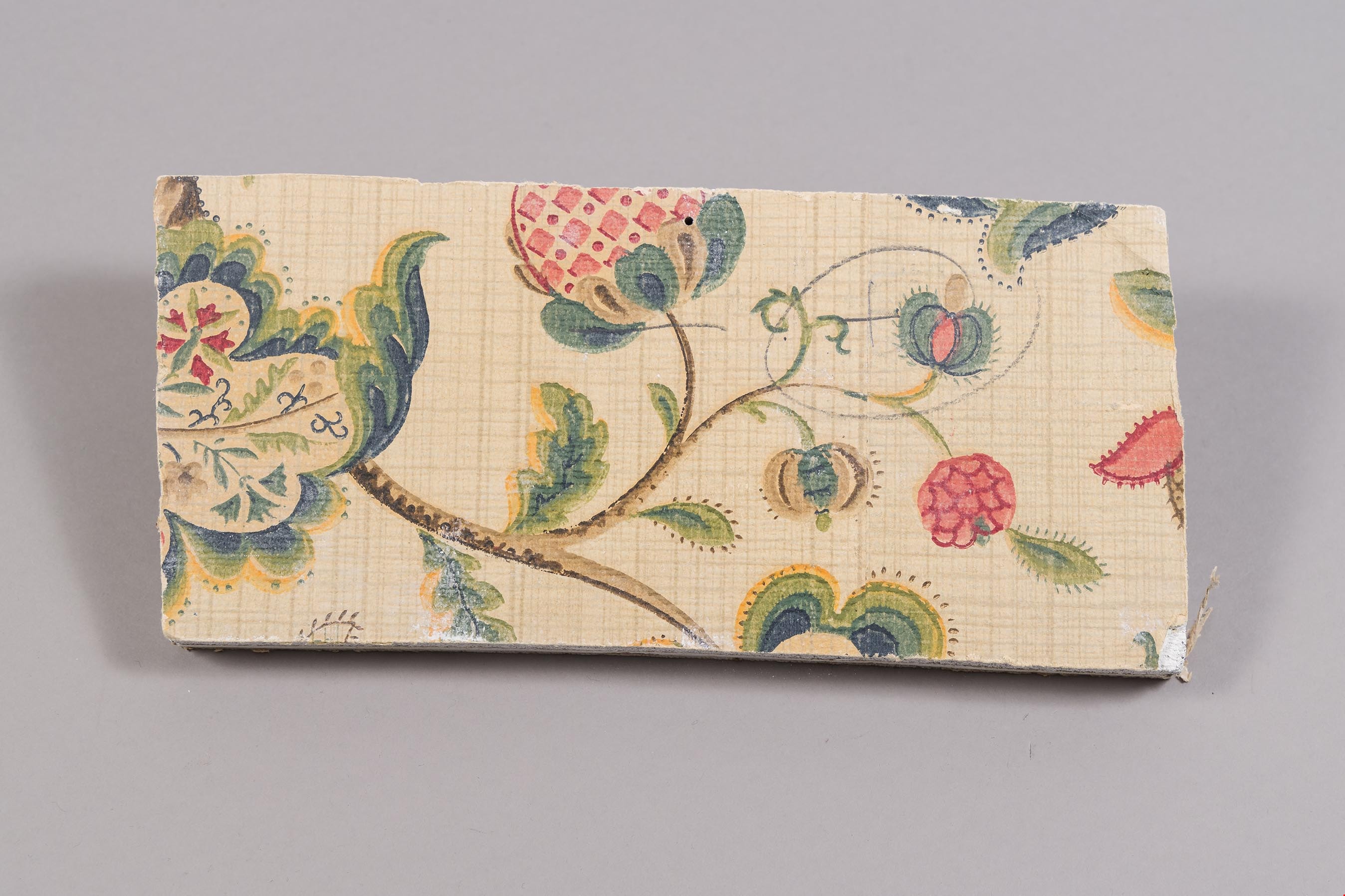
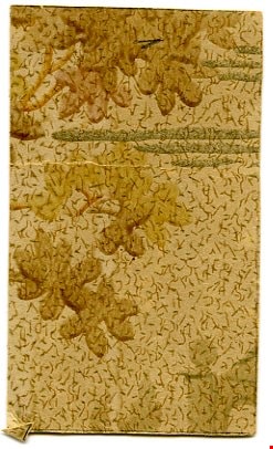
wallpaper fragment
https://search.heritageburnaby.ca/link/museumartifact40158
- Repository
- Burnaby Village Museum
- Accession Code
- BV988.33.93
- Description
- Piece of wallpaper, small, rectangular; light beige ground flecked with small green dashes and larger brown dashes and squiggles; brown and greenish watercolour leaf shapes, parallel metallic gold lines of varying lengths grouped in threes; back appears to have pieces of other wall papers attached
- Object History
- This artifact was found in Love Farmhouse, in the bedroom, when one of the thermostats was found.
- Names
- Love, Jesse, 1849-1928
- Geographic Access
- Cumberland Street
- Historic Neighbourhood
- East Burnaby (Historic Neighbourhood)
Images
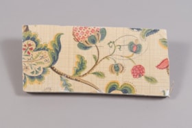
wall section
https://search.heritageburnaby.ca/link/museumartifact81703
- Repository
- Burnaby Village Museum
- Accession Code
- BV988.33.108
- Description
- A section of wall board and plaster with a flower motif wallpaper on the top surface.
- Object History
- This item was taken from Love farmhouse. It is unknown what room the fragment is from.
- Measurements
- 13 cm. X 28.5 cm X 2.5 cm thick. ( plaster 1.5 cm and wallboard 1 cm)
- Geographic Access
- Cumberland Street
- Historic Neighbourhood
- East Burnaby (Historic Neighbourhood)
Images