More like 'Hotel Burnaby'
Narrow Results By
Subject
- Accidents - Automobile Accidents 1
- Adornment 10
- Adornment - Jewelry 2
- Adornment - Lapel Pins 10
- Advertising Medium 103
- Advertising Medium - Business Cards 17
- Advertising Medium - Flyer 38
- Advertising Medium - Poster 18
- Advertising Medium - Signs and Signboards 262
- Aerial Photographs 27
- Agricultural Tools and Equipment - Plows 3
- Agriculture 4

Duncan & Margaret McGregor Estate 'Glen-Lyon' Mansion
https://search.heritageburnaby.ca/link/landmark518
- Repository
- Burnaby Heritage Planning
- Description
- Overlooking the rich farmland of the Fraser River floodplain, 'Glen-Lyon' is an Edwardian era rural estate, with a tall, two and one-half storey plus basement wood-frame mansion, set in a pastoral and formal landscape with an associated barn and early log pond, located near a ravine and forested ar…
- Associated Dates
- 1902
- Formal Recognition
- Heritage Designation, Community Heritage Register
- Street View URL
- Google Maps Street View
- Repository
- Burnaby Heritage Planning
- Geographic Access
- Marine Drive
- Associated Dates
- 1902
- Formal Recognition
- Heritage Designation, Community Heritage Register
- Enactment Type
- Bylaw No. 12183
- Enactment Date
- 11/12/2006
- Description
- Overlooking the rich farmland of the Fraser River floodplain, 'Glen-Lyon' is an Edwardian era rural estate, with a tall, two and one-half storey plus basement wood-frame mansion, set in a pastoral and formal landscape with an associated barn and early log pond, located near a ravine and forested area adjacent to Marine Drive in South Burnaby.
- Heritage Value
- ‘Glen-Lyon’ is valued as an excellent example of a privately-owned Edwardian era country estate built at the turn of the nineteenth century. The property retains significant heritage features including the Edwardian era mansion with rustic Arts and Crafts features, and elements of a working agricultural landscape. The property was originally the Royal City Mills logging camp, and in 1900 was purchased by Duncan Campbell McGregor (1853-1929) and Margaret Jane McGregor (1875-1960), who named their estate ‘Glen-Lyon’ after Duncan McGregor’s birthplace in Perthshire, Scotland. The McGregors were active in municipal affairs and social activities, and played a significant role in the early development of Burnaby. Duncan McGregor served as a city councillor from 1909 to 1912 and was elected reeve of Burnaby in 1913. Margaret McGregor was instrumental in the formation and fundraising activities of the Victoria Order of Nurses in Burnaby. Additionally, the site is historically significant for its association with early social welfare and correctional reform. The estate was sold in 1926 to an inter-denominational religious organization called the Home of the Friendless, which used it as their B.C. headquarters. The organization was charged with several cases of abuse and neglect in 1937, after which a Royal Commission was formed that led to new legislation to regulate and license all private welfare institutions. 'Glen-Lyon' was sold to the provincial government, and was dedicated in 1939 by the Lt.-Gov. E.W. Hamber for use as the New Haven Borstal Home for Boys and Youthful Offenders (later renamed the New Haven Correction Centre). The Borstal movement originated in England in the late nineteenth century, as an alternative to sending young offenders and runaways to prisons by providing reformatories that focused on discipline and vocational skill. This site’s role as the first North American institution devoted to the Borstal School philosophy was historic, and influenced corrections programs across Canada. The site retains significant features from its development in 1939 as the Borstal School, including a large gambrel-roofed barn designed by Chief Provincial Architect Henry Whittaker of the Department of Public Works that is the only remaining structure of its kind in Burnaby. Between 1941 and 1945 the mansion housed the Provincial School for the Deaf and Blind when the Borstal School was closed temporarily as a war measure during the Second World War.
- Defining Elements
- Key elements that define the heritage character of 'Glen-Lyon' Mansion include its: - location on a sloping site with expansive southern exposure, adjacent to Marine Drive - residential form, scale and massing of the house as exemplified by its two and one-half storey height, above-ground basement and rectangular plan - Arts and Crafts elements of the house such as its stone foundation, multi-gabled roof line with steep central hipped roof, symmetrical cross-gables, side shed dormers, bellcast upper walls sheathed in cedar shingles and lower walls sheathed in narrow clapboard - original exterior features of the house such as the full width front verandah with square columns, central staircase on the southern elevation, original doors and stained glass windows; and the irregular fenestration such as double-hung 1-over-1 wooden-sash windows, bay windows, and projecting windows in the gable ends - original interior features of the house such as the U-shaped main stair designed around two symmetrically placed Ionic columns, and interior trim on the main floor including boxed beams and fireplaces - gambrel-roofed barn with roof vent with finial, sliding hay loft and access doors, small multi-pane windows, and lapped wooden siding - associated landscape features such as the original garden plantings with some exotic and many native specimen trees; the original log pond and its concrete Marine Drive causeway and culvert; rockeries and a rose garden
- Historic Neighbourhood
- Fraser Arm (Historic Neighbourhood)
- Planning Study Area
- Big Bend Area
- Architect
- Henry Whittaker
- Function
- Primary Historic--Estate
- Community
- Burnaby
- Cadastral Identifier
- 003-004-661
- Boundaries
- 'Glen-Lyon' is comprised of a single residential lot located at 4250 Marine Drive, Burnaby.
- Area
- 230873.18
- Contributing Resource
- Building
- Ownership
- Private
- Names
- McGregor, Duncan C. (1853-1929)
- Whittaker, Henry
- Home of the Friendless
- Borstal School
- New Haven Correction Centre
- Subjects
- Buildings - Heritage
- Buildings - Residential - Houses
- Buildings - Public - Detention Facilities
- Buildings - Residential
- Street Address
- 4250 Marine Drive
- Street View URL
- Google Maps Street View
Images


E.W. Bateman House 'Elworth'
https://search.heritageburnaby.ca/link/landmark538
- Repository
- Burnaby Heritage Planning
- Description
- The E.W. Bateman House is a one-and-one-half storey wood-frame residence set within in a garden landscape. The house and its adjacent garage are the only historic buildings standing on their original site within the Burnaby Village Museum property.
- Associated Dates
- 1922
- Formal Recognition
- Heritage Designation, Community Heritage Register
- Other Names
- Edwin & Mary Bateman Residence
- Street View URL
- Google Maps Street View
- Repository
- Burnaby Heritage Planning
- Other Names
- Edwin & Mary Bateman Residence
- Geographic Access
- Deer Lake Avenue
- Associated Dates
- 1922
- Formal Recognition
- Heritage Designation, Community Heritage Register
- Enactment Type
- Bylaw No. 9807
- Enactment Date
- 23/11/1992
- Description
- The E.W. Bateman House is a one-and-one-half storey wood-frame residence set within in a garden landscape. The house and its adjacent garage are the only historic buildings standing on their original site within the Burnaby Village Museum property.
- Heritage Value
- The E.W. Bateman House was constructed in the Deer Lake Crescent subdivision, that was originally promoted in 1911 as an upper class suburban neighbourhood. It represents one of the first residential developments in the City of Burnaby that required buildings to be of a specific value, thus demonstrating the desire for exclusivity among the successful businessmen who chose to settle in the area. The house and grounds illustrate the reduced scale of upper-class residential construction at a time of modest returning prosperity that followed the end of the First World War, and the social, cultural, lifestyle and leisure sensibilities of the owners in the Deer Lake Crescent subdivision: such values as social aspiration, racial exclusivity, demonstration of architectural taste, and importance of a landscaped garden. The heritage value of the E.W. Bateman House is its comprehensive representation of an upper middle-class suburban residence of the early 1920s. It was built for retired CPR executive Edwin Wettenhall Bateman (1859-1957) and his wife, Mary (Dale) Bateman (1865-1935), by contractor William Dodson in 1922. The Bateman House was designed by English-born and trained architect Enoch Evans (1862-1939) of E. Evans and Son, and is an important surviving residential design by Evans, and a typical example of the eclectic Period Revival influences that were common to domestic architecture in the post-First World War era. The symmetry of the imposing front verandah, supported by exaggerated Ionic columns, gives the relatively-modest house an image of grandeur and formality. Named after Edwin Bateman’s birthplace in Cheshire, England, ‘Elworth’ also symbolizes allegiance to England and the patriotic tenor of the time. The heritage value for this house also lies in its interpretive value within the Burnaby Village Museum. The site is an important cultural feature for the interpretation of Burnaby’s heritage to the public. The E.W. Bateman House was purchased by Burnaby in 1970 and became the focal point for the development of the Museum. Both the interior and exterior of the house have been restored and interpreted to the date of original construction, including recreated room interiors and period furnishings.
- Defining Elements
- The elements that define the heritage character of the E.W. Bateman House include its: - rectangular form and massing with central entry on long side - side gable roof with front shed dormer with cedar shingle cladding - symmetry of front facade - full open front verandah inset under the roofline, supported with Ionic columns - cedar shingle siding - multi-paned double-hung wooden-sash windows, mixture of 6-over-1 and 8-over-1 - symmetrical disposition of fenestration, with double-assembly units on the ground floor - exterior shutters - two flanking brick chimneys on the side elevations - interior room layouts and original interior features such as quality millwork and original hardware - original garage at the rear of the house
- Locality
- Deer Lake Park
- Historic Neighbourhood
- Burnaby Lake (Historic Neighbourhood)
- Planning Study Area
- Morley-Buckingham Area
- Organization
- Burnaby Village Museum
- Architect
- Enoch Evans
- E. Evans and Son
- Builder
- William Dodson
- Function
- Primary Current--Museum
- Primary Historic--Single Dwelling
- Community
- Burnaby
- Cadastral Identifier
- P.I.D. No. 011-030-356 Legal Description: Parcel 1, District Lot 79 and District Lot 85, Group 1, New Westminster District, Reference Plan 77594
- Boundaries
- Burnaby Village Museum is comprised of a single municipally-owned property located at 6501 Deer Lake Avenue, Burnaby.
- Area
- 38,488.63
- Contributing Resource
- Building
- Landscape Feature
- Structure
- Ownership
- Public (local)
- Documentation
- Heritage Site Files: PC77000 20. City of Burnaby Planning and Building Department, 4949 Canada Way, Burnaby, B.C., V5G 1M2
- Subjects
- Buildings - Residential
- Buildings - Residential - Houses
- Buildings - Heritage
- Buildings - Civic - Museums
- Street Address
- 6501 Deer Lake Avenue
- Street View URL
- Google Maps Street View
Images


Barnet Lumber Company House
https://search.heritageburnaby.ca/link/landmark662
- Repository
- Burnaby Heritage Planning
- Description
- Residential building.
- Associated Dates
- 1925
- Street View URL
- Google Maps Street View
- Repository
- Burnaby Heritage Planning
- Geographic Access
- Texaco Drive
- Associated Dates
- 1925
- Description
- Residential building.
- Heritage Value
- This house is one of two surviving houses built as a “Model Home” for the manager of the Barnet Lumber Company, which was the successor to the North Pacific Lumber Company. It was used as a combined home and office. It was constructed with framing lumber and millwork sawn at the mill. Typical of the Craftsman style, the house has a front gabled roof with triangular eave brackets. It has been altered with the addition of asbestos shingles over the original siding, but retains its form, scale and massing. This house was designed by the firm of Townley & Matheson. The partnership of Fred Laughton Townley (1887-1966) and Robert Michael Matheson began in 1919, and the firm left a rich legacy of sophisticated work, including schools, commercial structures, many fine residences and the landmark Vancouver City Hall.
- Historic Neighbourhood
- Barnet (Historic Neighbourhood)
- Planning Study Area
- Burnaby Mountain Area
- Architect
- Townley & Matheson
- Area
- 2225.77
- Contributing Resource
- Building
- Ownership
- Public (local)
- Street Address
- 8007 Texaco Drive
- Street View URL
- Google Maps Street View
Images


Barnet Lumber Company House
https://search.heritageburnaby.ca/link/landmark663
- Repository
- Burnaby Heritage Planning
- Description
- Residential building.
- Associated Dates
- 1925
- Street View URL
- Google Maps Street View
- Repository
- Burnaby Heritage Planning
- Geographic Access
- Texaco Drive
- Associated Dates
- 1925
- Description
- Residential building.
- Heritage Value
- This house is one of two surviving houses built as a “Model Home” for one of the assistant managers of the Barnet Lumber Company, using framing lumber and millwork sawn at the mill. This house was also designed by the firm of Townley & Matheson. The house was raised and renovated in 1997, resulting in alterations such as new dormers and elongated porch piers.
- Historic Neighbourhood
- Barnet (Historic Neighbourhood)
- Planning Study Area
- Burnaby Mountain Area
- Architect
- Townley & Matheson
- Contributing Resource
- Building
- Ownership
- Private
- Street Address
- 8039 Texaco Drive
- Street View URL
- Google Maps Street View
Images


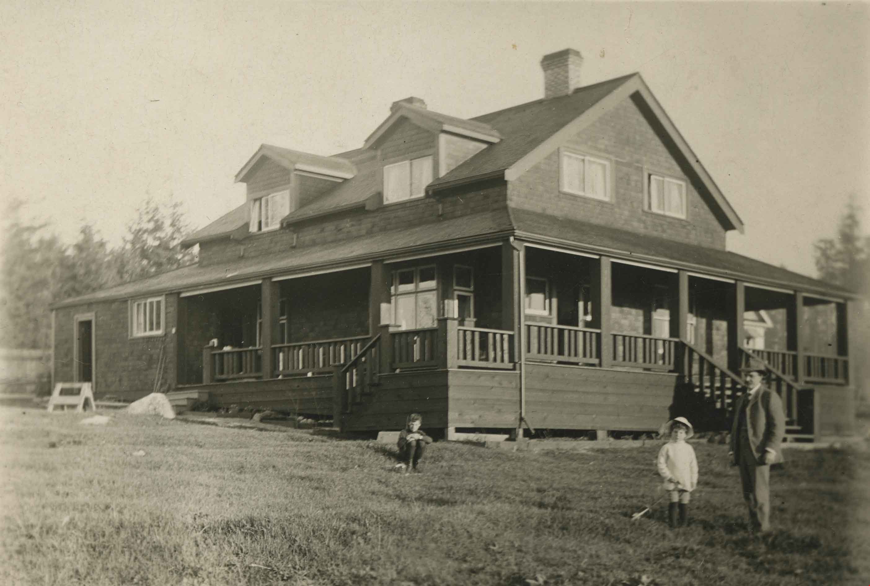
H.T. Ceperley Estate 'Fairacres' Mansion
https://search.heritageburnaby.ca/link/landmark526
- Repository
- Burnaby Heritage Planning
- Description
- 'Fairacres' is a large, two-and-one-half storey estate house in the British Arts and Crafts style, located in Deer Lake Park, with four associated original outbuildings.
- Associated Dates
- 1911
- Formal Recognition
- Heritage Designation, Community Heritage Register
- Other Names
- Henry Tracy & Grace Ceperley Estate
- Burnaby Art Gallery
- Street View URL
- Google Maps Street View
- Repository
- Burnaby Heritage Planning
- Other Names
- Henry Tracy & Grace Ceperley Estate
- Burnaby Art Gallery
- Geographic Access
- Deer Lake Avenue
- Associated Dates
- 1911
- Formal Recognition
- Heritage Designation, Community Heritage Register
- Enactment Type
- Bylaw No. 9807
- Enactment Date
- 23/11/1992
- Description
- 'Fairacres' is a large, two-and-one-half storey estate house in the British Arts and Crafts style, located in Deer Lake Park, with four associated original outbuildings.
- Heritage Value
- 'Fairacres' is important as a record of the early years of Burnaby, specifically the Deer Lake area, as a place of tranquility and beautiful scenery in which the wealthy and successful in the burgeoning cities of New Westminster and Vancouver chose to retire or to make their family homes. The main house, which anchors in style and setting the outbuildings on the estate, demonstrates the social, cultural, and aesthetic values of local wealthy businessmen and women of the early twentieth century - values such as appreciation of architectural elegance and grand interior spaces, leisure and recreation, formal landscaped gardens and scenic views. Also important is the association with the English-born and trained architect Robert Mackay Fripp (1858-1917), as this was one of his grandest residential commissions. Steeped in the current architectural trends in Great Britain, Fripp designed this sprawling mansion in the Arts and Crafts style, reflected in the architectural detailing and proportions. The style was common at the time and was often used for estate mansions as a symbol of affluence and good, modern taste as well as an affinity for all things British. Quality is displayed inside and out in the finishes and materials, orchestrated by prominent local contractor, James Charles Allen, including imported English materials of specific value such as imported Medmenham tiles in the fireplace surrounds, one of the earliest documented use of these tiles outside the United Kingdom. Detailed features of the interior woodwork were carved by Scottish-born master wood carver George Selkirk Gibson (1867-1942), who was best known for his many commissions for prominent British Columbia architect Samuel Maclure. The outbuildings at 'Fairacres' are an important record of the functioning of a large estate of the time. The Garage and Stables and the Chauffeur’s Cottage accommodated the use of automobiles, horses and carriages, and in concert with the estate's location near the new British Columbia Electric Railway 'Burnaby Lake' interurban line, illustrate the evolving nature of regional transportation and the growing bedroom communities and estates made possible by increasing options for transportation. Other outbuildings accommodated the agricultural activities that helped support the Ceperley estate. The estate was conceived and funded by American-born Grace E. Dixon Ceperley (1863-1917), who had achieved significant wealth through a bequest from her brother-in-law, Vancouver pioneer Arthur Ferguson. Her husband, Henry Tracy Ceperley (1850-1929), also American-born, was a successful and well-respected businessman who made a significant contribution to the development of the City of Vancouver. The construction of 'Fairacres' spawned the transformation of the Deer Lake area from a farming community into a preferred location for elite suburban homes. 'Fairacres' is significant to the City of Burnaby as its first civic heritage conservation project. Acquired in 1966 for conversion to Burnaby’s first art gallery, it was dedicated in 1967 to mark Canada’s Centennial of Confederation.
- Defining Elements
- Key elements that define the heritage character of the ‘Fairacres’ mansion include its: - setting in relation to the gardens, its former market garden, and the vistas to Deer Lake and other grand homes in the area - side gable roof with prominent dormers and cedar shingle cladding - verandah across the eastern (garden) facade, with its view over the landscaped gardens and the distant mountains - porte cochere with its side steps for those arriving by automobile, and central raised step for those alighting from horse-drawn carriages - rich variety of exterior elements that demonstrate the typical Arts and Crafts use of local materials such as cobble stone chimneys and foundations, wide wooden siding and half-timbering - mixture of double-hung and casement wooden-sash windows, many with multi-paned sash - lavish interior spaces, designed for entertaining on a grand scale, including a billiard room with a beamed ceiling and an inglenook fireplace, and generous living and dining rooms arranged off a central hall - quality of the interior materials such as imported Medmenham tiles in fireplace surrounds, window hardware by Hope and Sons, and leaded stained glass - interior wood work including the staircase, and carvings by George Selkirk Gibson - remaining formal Edwardian garden landscape elements, including the cross-axial plan that reflects the relationship of the mansion to its 'outdoor rooms'
- Locality
- Deer Lake Park
- Historic Neighbourhood
- Burnaby Lake (Historic Neighbourhood)
- Planning Study Area
- Douglas-Gilpin Area
- Architect
- Robert Mackay Fripp
- Function
- Primary Current--Museum
- Primary Historic--Estate
- Community
- Burnaby
- Cadastral Identifier
- P.I.D. No. 004-493-311 Legal Description: Block 3 Except: Part subdivided by Plan 26865, District Lot 79, Group 1, New Westminster District, Plan 536
- Boundaries
- ‘Fairacres’ is comprised of a single municipally-owned property located at 6344 Deer Lake Avenue, Burnaby.
- Area
- 17,065.00
- Contributing Resource
- Building
- Landscape Feature
- Ownership
- Public (local)
- Other Collection
- City of Burnaby, Visual Art Collection: Original rendering by R.P.S. Twizell Burnaby Historical Society, Community Archives: Ceperley Photograph Album Burnaby Village Museum, Collection: Carved dining room panels by G.S. Gibson and other hardware items
- Documentation
- Heritage Site Files: PC77000 20. City of Burnaby Planning and Building Department, 4949 Canada Way, Burnaby, B.C., V5G 1M2
- Names
- Ceperley, Grace
- Ceperley, H.T.
- Fripp, Robert Mackay
- Allen, James Charles
- Gibson, George Selkirk
- Street Address
- 6344 Deer Lake Avenue
- Street View URL
- Google Maps Street View
Images


![Some of our homes, [1907] thumbnail](/media/hpo/_Data/_Archives_Images/_Unrestricted/371/411-006.jpg?width=280)
Some of our homes
https://search.heritageburnaby.ca/link/archivedescription38347
- Repository
- City of Burnaby Archives
- Date
- [1907]
- Collection/Fonds
- Burnaby Historical Society fonds
- Description Level
- Item
- Physical Description
- 1 photograph : b&w postcard ; 8.5 x 14 cm
- Scope and Content
- Photographic postcard of three houses at Barnet as well as the railway station. A caption on the card reads: "Some of our homes / Barnet B.C."
- Repository
- City of Burnaby Archives
- Date
- [1907]
- Collection/Fonds
- Burnaby Historical Society fonds
- Subseries
- Charles Lee subseries
- Physical Description
- 1 photograph : b&w postcard ; 8.5 x 14 cm
- Description Level
- Item
- Record No.
- 411-006
- Access Restriction
- No restrictions
- Reproduction Restriction
- No known restrictions
- Accession Number
- BHS2000-13
- Scope and Content
- Photographic postcard of three houses at Barnet as well as the railway station. A caption on the card reads: "Some of our homes / Barnet B.C."
- Subjects
- Buildings - Residential - Houses
- Documentary Artifacts - Postcards
- Buildings - Commercial - Train Stations
- Media Type
- Photograph
- Notes
- Title taken from caption
- Geographic Access
- Barnet Village
- Barnet Road
- Street Address
- 8181 Barnet Road
- Historic Neighbourhood
- Barnet (Historic Neighbourhood)
- Planning Study Area
- Burnaby Mountain Area
Images
![Some of our homes, [1907] thumbnail](/media/hpo/_Data/_Archives_Images/_Unrestricted/371/411-006.jpg)
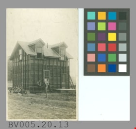
postcard
https://search.heritageburnaby.ca/link/museumartifact48364
- Repository
- Burnaby Village Museum
- Accession Code
- BV005.20.13
- Description
- Postcard: black and white photo, white border; vertical; shows two-storey wood-frame house during construction; two men sit on saw horse? in front, ladder visible against one side; wire fence between house and photographer; pencilled in border at bottom right, "1911 Burnaby"; no exact location identified; on reverse in black, "POST CARD"; short wavy line below and one extending about a centimetre down centre; at left, "CORRESPONDENCE", at right "ADDRESS"; dotted outline of rectangle at upper right; unused; soiled, stained and spotted; darkened around edges; creases; corners worn; impression of postmark, "11" very clear
- Classification
- Written Communication T&E - - Writing Media
- Object Term
- Postcard
- Marks/Labels
- 1911 Burnaby
- Colour
- Black
- White
- Country Made
- Canada
- Province Made
- British Columbia
- Site/City Made
- Burnaby
- Title
- 1911 Burnaby
- Publication Date
- 1911
- Subjects
- Documentary Artifacts
- Documentary Artifacts - Postcards
- Buildings
- Buildings - Residential
- Buildings - Residential - Houses
Images

![A Pretty Dwelling, Barnet, [191-] thumbnail](/media/hpo/_Data/_Archives_Images/_Unrestricted/540/540-027.jpg?width=280)
A Pretty Dwelling, Barnet
https://search.heritageburnaby.ca/link/archivedescription73619
- Repository
- City of Burnaby Archives
- Date
- [191-]
- Collection/Fonds
- LaFavor Family fonds
- Description Level
- Item
- Physical Description
- 1 photograph : sepia postcard ; 8.5 x 14 cm
- Scope and Content
- Photographic postcard of house in Barnet, BC, in which the image is entitled "A Pretty Dwelling."
- Repository
- City of Burnaby Archives
- Date
- [191-]
- Collection/Fonds
- LaFavor Family fonds
- Physical Description
- 1 photograph : sepia postcard ; 8.5 x 14 cm
- Description Level
- Item
- Record No.
- 540-027
- Access Restriction
- No restrictions
- Reproduction Restriction
- No restrictions
- Accession Number
- 2007-03
- Scope and Content
- Photographic postcard of house in Barnet, BC, in which the image is entitled "A Pretty Dwelling."
- Subjects
- Documentary Artifacts - Postcards
- Buildings - Residential - Houses
- Industries - Logging/lumber
- Names
- Barnet Mill
- Media Type
- Photograph
- Notes
- Transcribed title
- Geographic Access
- Barnet Village
- Texaco Drive
- Historic Neighbourhood
- Barnet (Historic Neighbourhood)
- Planning Study Area
- Burnaby Mountain Area
Images
![A Pretty Dwelling, Barnet, [191-] thumbnail](/media/hpo/_Data/_Archives_Images/_Unrestricted/540/540-027.jpg)
![A Pretty Dwelling, Barnet B.C., [1907] thumbnail](/media/hpo/_Data/_Archives_Images/_Unrestricted/371/411-008.jpg?width=280)
A Pretty Dwelling, Barnet B.C.
https://search.heritageburnaby.ca/link/archivedescription38349
- Repository
- City of Burnaby Archives
- Date
- [1907]
- Collection/Fonds
- Burnaby Historical Society fonds
- Description Level
- Item
- Physical Description
- 1 photograph : sepia postcard ; 8.5 x 14 cm
- Scope and Content
- Photograph of the front garden and exterior of the North Pacific Lumber Co. (NPLC) Manager's house at Barnet. The caption on the card reads: "A Pretty Dwelling, Barnet B.C."
- Repository
- City of Burnaby Archives
- Date
- [1907]
- Collection/Fonds
- Burnaby Historical Society fonds
- Subseries
- Charles Lee subseries
- Physical Description
- 1 photograph : sepia postcard ; 8.5 x 14 cm
- Description Level
- Item
- Record No.
- 411-008
- Access Restriction
- No restrictions
- Reproduction Restriction
- No known restrictions
- Accession Number
- BHS2000-13
- Scope and Content
- Photograph of the front garden and exterior of the North Pacific Lumber Co. (NPLC) Manager's house at Barnet. The caption on the card reads: "A Pretty Dwelling, Barnet B.C."
- Media Type
- Photograph
- Notes
- Title taken from caption
- Geographic Access
- Barnet Village
- Barnet Road
- Street Address
- 8181 Barnet Road
- Historic Neighbourhood
- Barnet (Historic Neighbourhood)
- Planning Study Area
- Burnaby Mountain Area
Images
![A Pretty Dwelling, Barnet B.C., [1907] thumbnail](/media/hpo/_Data/_Archives_Images/_Unrestricted/371/411-008.jpg)

B.G. Walker house
https://search.heritageburnaby.ca/link/archivedescription35002
- Repository
- City of Burnaby Archives
- Date
- 1910 (date of original), copied 1986
- Collection/Fonds
- Burnaby Historical Society fonds
- Description Level
- Item
- Physical Description
- 1 photograph : b&w postcard ; 8.4 x 13.8 cm
- Scope and Content
- Photographic postcard of the B.G. Walker house, Edmonds Street and Kingsway. Note the cedar stumps in background.
- Repository
- City of Burnaby Archives
- Date
- 1910 (date of original), copied 1986
- Collection/Fonds
- Burnaby Historical Society fonds
- Subseries
- Patterson family subseries
- Physical Description
- 1 photograph : b&w postcard ; 8.4 x 13.8 cm
- Description Level
- Item
- Record No.
- 171-023
- Access Restriction
- Open access
- Reproduction Restriction
- No known restrictions
- Accession Number
- BHS1986-20
- Scope and Content
- Photographic postcard of the B.G. Walker house, Edmonds Street and Kingsway. Note the cedar stumps in background.
- Media Type
- Photograph
- Notes
- Title based on contents of photograph
- Geographic Access
- Edmonds Street
- Kingsway
- Historic Neighbourhood
- Edmonds (Historic Neighbourhood)
Images

![Fred Holdsworth and his wife in front of their house, [1912] thumbnail](/media/hpo/_Data/_BVM_Images/1977/198000120001.jpg?width=280)
Fred Holdsworth and his wife in front of their house
https://search.heritageburnaby.ca/link/museumdescription3029
- Repository
- Burnaby Village Museum
- Date
- [1912]
- Collection/Fonds
- Burnaby Village Museum Photograph collection
- Description Level
- Item
- Physical Description
- 1 photograph : b&w postcard ; 13.9 x 8.5 cm
- Scope and Content
- Photographic postcard of Fred Holdsworth and his wife standing outside their Neville Street Home. The house is two storeys with an attic with windows. The porch is elevated with steep stairs leading to the front door, which is on the second floor. They are both standing with their hands on their hi…
- Repository
- Burnaby Village Museum
- Collection/Fonds
- Burnaby Village Museum Photograph collection
- Description Level
- Item
- Physical Description
- 1 photograph : b&w postcard ; 13.9 x 8.5 cm
- Scope and Content
- Photographic postcard of Fred Holdsworth and his wife standing outside their Neville Street Home. The house is two storeys with an attic with windows. The porch is elevated with steep stairs leading to the front door, which is on the second floor. They are both standing with their hands on their hips. There are variant spellings of "Holdsworth" used in the notes in the accession file. They are "Houldsworth" and "Hallsworth." The 1937 British Columbia directory lists a Fred Houldsworth at 3345 Neville Street, Burnaby. The address was later renumbered 5249 Neville Street.
- Geographic Access
- Neville Street
- Street Address
- 5249 Neville Street
- Accession Code
- HV980.12.1
- Access Restriction
- No restrictions
- Reproduction Restriction
- May be restricted by third party rights
- Date
- [1912]
- Media Type
- Photograph
- Historic Neighbourhood
- Alta-Vista (Historic Neighbourhood)
- Planning Study Area
- Clinton-Glenwood Area
- Scan Resolution
- 600
- Scan Date
- 2023-09-12
- Notes
- Title based on contents of photograph
Images
![Fred Holdsworth and his wife in front of their house, [1912] thumbnail](/media/hpo/_Data/_BVM_Images/1977/198000120001.jpg)
Greyfriars
https://search.heritageburnaby.ca/link/archivedescription34294
- Repository
- City of Burnaby Archives
- Date
- 1912
- Collection/Fonds
- Burnaby Historical Society fonds
- Description Level
- Item
- Physical Description
- 1 photograph : b&w postcard ; 8.8 x 13.5 cm
- Scope and Content
- Photographic postcard of "Greyfriars," the F.J. Peers House in the Burnaby Lake area. Standing in front of the home are two children and a man who may be Francis J. Peers. The children are unidentified.
- Repository
- City of Burnaby Archives
- Date
- 1912
- Collection/Fonds
- Burnaby Historical Society fonds
- Subseries
- Peers family subseries
- Physical Description
- 1 photograph : b&w postcard ; 8.8 x 13.5 cm
- Description Level
- Item
- Record No.
- 020-001
- Access Restriction
- No restrictions
- Reproduction Restriction
- No known restrictions
- Accession Number
- BHS2007-04
- Scope and Content
- Photographic postcard of "Greyfriars," the F.J. Peers House in the Burnaby Lake area. Standing in front of the home are two children and a man who may be Francis J. Peers. The children are unidentified.
- Names
- Peers, Francis J.
- Media Type
- Photograph
- Notes
- Title based on contents of photograph
- Geographic Access
- Rugby Street
- Street Address
- 5289 Rugby Avenue
- Historic Neighbourhood
- Burnaby Lake (Historic Neighbourhood)
- Planning Study Area
- Morley-Buckingham Area
Images
![Holdsworth House on Neville Street, [1912] thumbnail](/media/hpo/_Data/_BVM_Images/1977/198000120002.jpg?width=280)
Holdsworth House on Neville Street
https://search.heritageburnaby.ca/link/museumdescription3030
- Repository
- Burnaby Village Museum
- Date
- [1912]
- Collection/Fonds
- Burnaby Village Museum Photograph collection
- Description Level
- Item
- Physical Description
- 1 photograph : sepia postcard ; 8.8 x 13.8 cm
- Scope and Content
- Photographic postcard of the Holdsworth house on Neville Street. The house is two storeys with an attic with windows. The porch is elevated with steep stairs leading to the front door, which is on the second floor. There is a woman standing in the porch, looking towards the photographer. Another ho…
- Repository
- Burnaby Village Museum
- Collection/Fonds
- Burnaby Village Museum Photograph collection
- Description Level
- Item
- Physical Description
- 1 photograph : sepia postcard ; 8.8 x 13.8 cm
- Scope and Content
- Photographic postcard of the Holdsworth house on Neville Street. The house is two storeys with an attic with windows. The porch is elevated with steep stairs leading to the front door, which is on the second floor. There is a woman standing in the porch, looking towards the photographer. Another house is visible right beside the Holdsworth house. There are variant spellings of "Holdsworth" used in the notes in the accession file. They are "Houldsworth" and "Hallsworth." The 1937 British Columbia directory lists a Fred Houldsworth at 3345 Neville Street, Burnaby. The address was later renumbered 5249 Neville Street.
- Geographic Access
- Neville Street
- Street Address
- 5249 Neville Street
- Accession Code
- HV980.12.2
- Access Restriction
- No restrictions
- Reproduction Restriction
- May be restricted by third party rights
- Date
- [1912]
- Media Type
- Photograph
- Historic Neighbourhood
- Alta-Vista (Historic Neighbourhood)
- Planning Study Area
- Clinton-Glenwood Area
- Scan Resolution
- 600
- Scan Date
- 2023-09-12
- Notes
- Title based on contents of photograph
Images
![Holdsworth House on Neville Street, [1912] thumbnail](/media/hpo/_Data/_BVM_Images/1977/198000120002.jpg)
![Home of Arthur Lobley and his wife, [1915] thumbnail](/media/hpo/_Data/_BVM_Images/1976/1976_0236_0001_001.jpg?width=280)
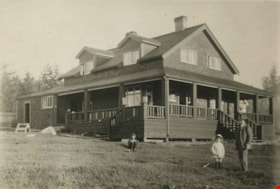
Home of Arthur Lobley and his wife
https://search.heritageburnaby.ca/link/museumdescription893
- Repository
- Burnaby Village Museum
- Date
- [1915]
- Collection/Fonds
- Burnaby Village Museum Photograph collection
- Description Level
- Item
- Physical Description
- 1 photograph : b&w postcard ; 9.0 x 13.9 cm
- Scope and Content
- Photographic postcard of a large three storey house with brick chimney and front balcony, with steps leading up to it. There are vegetable gardens around the house and a small tool shed on the left. There is an "x" marked on the left side of the photograph, with an annotation on the back reading: "…
- Repository
- Burnaby Village Museum
- Collection/Fonds
- Burnaby Village Museum Photograph collection
- Description Level
- Item
- Physical Description
- 1 photograph : b&w postcard ; 9.0 x 13.9 cm
- Scope and Content
- Photographic postcard of a large three storey house with brick chimney and front balcony, with steps leading up to it. There are vegetable gardens around the house and a small tool shed on the left. There is an "x" marked on the left side of the photograph, with an annotation on the back reading: "This is one side of house; x where front baclony is." Another annotation on the back of the photograph reads: "Home of Mr. and Mrs. Arthur Lobley on Marlborough Ave. S. Burnaby (just off Kingsway). Lobley Park named after Mr. Lobley." Arthur Lobley is credited for opening the Royal Oak Road to the tram station at Royal Oak in 1897, in George Green's book, "History of Burnaby," pg. 134.
- Geographic Access
- Marlborough Avenue
- Kingsway
- Accession Code
- HV976.236.1
- Access Restriction
- No restrictions
- Reproduction Restriction
- No known restrictions
- Date
- [1915]
- Media Type
- Photograph
- Historic Neighbourhood
- Central Park (Historic Neighbourhood)
- Planning Study Area
- Marlborough Area
- Scan Resolution
- 600
- Scan Date
- 2023-06-27
- Notes
- Title based on contents of photograph
Images
![Home of Arthur Lobley and his wife, [1915] thumbnail](/media/hpo/_Data/_BVM_Images/1976/1976_0236_0001_001.jpg)

Neville Street by Royal Oak
https://search.heritageburnaby.ca/link/museumdescription3031
- Repository
- Burnaby Village Museum
- Date
- 1912
- Collection/Fonds
- Burnaby Village Museum Photograph collection
- Description Level
- Item
- Physical Description
- 1 photograph : sepia postcard ; 8.8 x 13.9 cm
- Scope and Content
- Photographic postcard of Neville Street just off Royal Oak Avenue. The street is a dirt road lined with residential buildings on one side and eletric power poles on the other side. The Holdsworth house is seen being constructed on the left. There is scaffolding on the side of the building and a cle…
- Repository
- Burnaby Village Museum
- Collection/Fonds
- Burnaby Village Museum Photograph collection
- Description Level
- Item
- Physical Description
- 1 photograph : sepia postcard ; 8.8 x 13.9 cm
- Scope and Content
- Photographic postcard of Neville Street just off Royal Oak Avenue. The street is a dirt road lined with residential buildings on one side and eletric power poles on the other side. The Holdsworth house is seen being constructed on the left. There is scaffolding on the side of the building and a cleared lot beside the house. here are variant spellings of "Holdsworth" used in the notes in the accession file. They are "Houldsworth" and "Hallsworth." The 1937 British Columbia directory lists a Fred Houldsworth at 3345 Neville Street, Burnaby. The address was later renumbered 5249 Neville Street. An annotation on the back of the postcard reads: "Nevil [sic] Street - 1912 - Just off Royal Oak."
- Subjects
- Buildings - Residential - Houses
- Documentary Artifacts - Postcards
- Geographic Features - Roads
- Geographic Access
- Neville Street
- Royal Oak Avenue
- Accession Code
- HV980.12.3
- Access Restriction
- No restrictions
- Reproduction Restriction
- May be restricted by third party rights
- Date
- 1912
- Media Type
- Photograph
- Historic Neighbourhood
- Alta-Vista (Historic Neighbourhood)
- Planning Study Area
- Clinton-Glenwood Area
- Scan Resolution
- 600
- Scan Date
- 2023-09-12
- Notes
- Title based on contents of photograph
Images

![Some of Our Homes, Barnet, [1912] thumbnail](/media/Hpo/_Data/_Archives_Images/_Unrestricted/001/015-014.jpg?width=280)
Some of Our Homes, Barnet
https://search.heritageburnaby.ca/link/archivedescription39782
- Repository
- City of Burnaby Archives
- Date
- [1912]
- Collection/Fonds
- Burnaby Historical Society fonds
- Description Level
- Item
- Physical Description
- 1 photograph : b&w postcard ; 8.5 x 13.8 cm
- Scope and Content
- Photograph on a postcard shows row of houses along a street at Barnet Village. The postcard is postmarked July 30, 1912, Barnet, from Evelyn, who had travelled to Barnet, to her mother, Mrs. John Laity in Port Hammond, BC.
- Repository
- City of Burnaby Archives
- Date
- [1912]
- Collection/Fonds
- Burnaby Historical Society fonds
- Subseries
- Photographs subseries
- Physical Description
- 1 photograph : b&w postcard ; 8.5 x 13.8 cm
- Description Level
- Item
- Record No.
- 015-014
- Access Restriction
- No restrictions
- Reproduction Restriction
- No known restrictions
- Accession Number
- BHS2007-04
- Scope and Content
- Photograph on a postcard shows row of houses along a street at Barnet Village. The postcard is postmarked July 30, 1912, Barnet, from Evelyn, who had travelled to Barnet, to her mother, Mrs. John Laity in Port Hammond, BC.
- Subjects
- Buildings - Residential - Houses
- Documentary Artifacts - Postcards
- Geographic Features - Roads
- Names
- Barnet Mill
- Media Type
- Photograph
- Notes
- Caption at bottom of photograph reads, "Some of our homes, Barnet, B.C."
- Geographic Access
- Barnet Village
- Texaco Drive
- Street Address
- 8059 Texaco Drive
- Historic Neighbourhood
- Barnet (Historic Neighbourhood)
- Planning Study Area
- Burnaby Mountain Area
Images
![Some of Our Homes, Barnet, [1912] thumbnail](/media/Hpo/_Data/_Archives_Images/_Unrestricted/001/015-014.jpg)
![Stride family home, [between 1915 and 1920] thumbnail](/media/hpo/_Data/_Archives_Images/_Unrestricted/001/001-001.jpg?width=280)
Stride family home
https://search.heritageburnaby.ca/link/archivedescription34025
- Repository
- City of Burnaby Archives
- Date
- [between 1915 and 1920]
- Collection/Fonds
- Burnaby Historical Society fonds
- Description Level
- Item
- Physical Description
- 1 photograph : sepia postcard ; 8 x 14 cm
- Scope and Content
- Photographic postcard of the exterior of the Stride family home located at Kingsway and 18th Avenue. Two people are traveling in a Model T Ford (with the top down) along the street in front of the house.
- Repository
- City of Burnaby Archives
- Date
- [between 1915 and 1920]
- Collection/Fonds
- Burnaby Historical Society fonds
- Subseries
- Stride family subseries
- Physical Description
- 1 photograph : sepia postcard ; 8 x 14 cm
- Description Level
- Item
- Record No.
- 001-001
- Access Restriction
- No restrictions
- Reproduction Restriction
- No known restrictions
- Accession Number
- BHS2007-04
- Scope and Content
- Photographic postcard of the exterior of the Stride family home located at Kingsway and 18th Avenue. Two people are traveling in a Model T Ford (with the top down) along the street in front of the house.
- Subjects
- Buildings - Residential - Houses
- Documentary Artifacts - Postcards
- Transportation - Automobiles
- Media Type
- Photograph
- Notes
- Title based on contents of photograph
- Geographic Access
- Kingsway
- 18th Avenue
- Historic Neighbourhood
- Edmonds (Historic Neighbourhood)
Images
![Stride family home, [between 1915 and 1920] thumbnail](/media/hpo/_Data/_Archives_Images/_Unrestricted/001/001-001.jpg)

5486 Dominion Street
https://search.heritageburnaby.ca/link/archivedescription91871
- Repository
- City of Burnaby Archives
- Date
- 1971
- Collection/Fonds
- Small family fonds
- Description Level
- Item
- Physical Description
- 1 photograph : b&w ; 9 cm x 9 cm
- Scope and Content
- Photograph of the Small family's house at 5486 Dominion Street with a "For Sale" sign on the lawn. The house was put up for sale by Lauretta Small after she inherited the Roberts' house at 5538 Dominion Street in 1969. Lauretta, by then a widow, relocated back into the Roberts' house which was th…
- Repository
- City of Burnaby Archives
- Date
- 1971
- Collection/Fonds
- Small family fonds
- Physical Description
- 1 photograph : b&w ; 9 cm x 9 cm
- Description Level
- Item
- Record No.
- 620-052
- Access Restriction
- No restrictions
- Reproduction Restriction
- No reproduction permitted
- Accession Number
- 2017-01
- Scope and Content
- Photograph of the Small family's house at 5486 Dominion Street with a "For Sale" sign on the lawn. The house was put up for sale by Lauretta Small after she inherited the Roberts' house at 5538 Dominion Street in 1969. Lauretta, by then a widow, relocated back into the Roberts' house which was the house she grew up in as a child.
- Media Type
- Photograph
- Notes
- Transcribed title
- Title transcribed from donor's notes
- Note in blue ink on verso of photograph reads: "P.14"
- Note in blue ink on verso of photograph reads: "5486 Dominion St / Burnaby, B.C. / Fall '71"
- 5486 Dominion Street later subdivided into two lots: 5480 and 5488 Dominion Street
- Street Address
- 5486 Dominion Street
- Historic Neighbourhood
- Burnaby Lake (Historic Neighbourhood)
- Planning Study Area
- Ardingley-Sprott Area
Images


Lillian Mann's property
https://search.heritageburnaby.ca/link/archivedescription46242
- Repository
- City of Burnaby Archives
- Date
- March 1983
- Collection/Fonds
- Columbian Newspaper collection
- Description Level
- Item
- Physical Description
- 1 photograph : b&w ; 15.5 x 23.5 cm
- Scope and Content
- Photograph of Lillian Mann's property, with signs which read such things as; "Forced Sale", "Expropriation Sale!" and Demolition Sale!" posted up along the front yard, and nailed to the large Cedar tree.
- Repository
- City of Burnaby Archives
- Date
- March 1983
- Collection/Fonds
- Columbian Newspaper collection
- Physical Description
- 1 photograph : b&w ; 15.5 x 23.5 cm
- Description Level
- Item
- Record No.
- 480-1130
- Access Restriction
- No restrictions
- Reproduction Restriction
- No restrictions
- Accession Number
- 2003-02
- Scope and Content
- Photograph of Lillian Mann's property, with signs which read such things as; "Forced Sale", "Expropriation Sale!" and Demolition Sale!" posted up along the front yard, and nailed to the large Cedar tree.
- Media Type
- Photograph
- Photographer
- King, Basil
- Notes
- Title based on contents of photograph
- Newspaper clipping attached to verso of photograph reads: "READY TO MOVE ... Lillian Mann, the Burnaby homeowner who waged a lengthy but unsuccessful battle against expropriation of her Cameron Street home, is ready to move. But she hasn't lost her spark, as the terse messages on her front lawn indicate. The property is to become a parking lot for the Cameron Public Library."
- Geographic Access
- Cameron Street
- Historic Neighbourhood
- Burquitlam (Historic Neighbourhood)
- Planning Study Area
- Lyndhurst Area
Images

![Mildred Herolz, [1930] (date of original), copied 1991 thumbnail](/media/hpo/_Data/_Archives_Images/_Unrestricted/370/370-568.jpg?width=280)
Mildred Herolz
https://search.heritageburnaby.ca/link/archivedescription37981
- Repository
- City of Burnaby Archives
- Date
- [1930] (date of original), copied 1991
- Collection/Fonds
- Burnaby Historical Society fonds
- Description Level
- Item
- Physical Description
- 1 photograph : b&w ; 4.6 x 2.4 cm print on contact sheet 20.7 x 26.2 cm
- Scope and Content
- Photograph of Mildred Herolz reading outside her Deer Lake Drive home.
- Repository
- City of Burnaby Archives
- Date
- [1930] (date of original), copied 1991
- Collection/Fonds
- Burnaby Historical Society fonds
- Subseries
- Burnaby Image Bank subseries
- Physical Description
- 1 photograph : b&w ; 4.6 x 2.4 cm print on contact sheet 20.7 x 26.2 cm
- Description Level
- Item
- Record No.
- 370-568
- Access Restriction
- No restrictions
- Reproduction Restriction
- No known restrictions
- Accession Number
- BHS1999-03
- Scope and Content
- Photograph of Mildred Herolz reading outside her Deer Lake Drive home.
- Names
- Heroly, Mildred
- Media Type
- Photograph
- Notes
- Title based on contents of photograph
- 1 b&w copy negative accompanying
- Geographic Access
- Deer Lake Drive
- Historic Neighbourhood
- Burnaby Lake (Historic Neighbourhood)
- Planning Study Area
- Morley-Buckingham Area
Images
![Mildred Herolz, [1930] (date of original), copied 1991 thumbnail](/media/hpo/_Data/_Archives_Images/_Unrestricted/370/370-568.jpg)