Narrow Results By
Subject
- Accidents 1
- Accidents - Automobile Accidents 3
- Adornment - Lapel Pins 1
- Advertising Medium 2
- Advertising Medium - Poster 1
- Advertising Medium - Signs and Signboards
- Aerial Photographs
- Agricultural Tools and Equipment 3
- Agriculture - Crops 4
- Agriculture - Farms 18
- Agriculture - Fruit and Berries 1
- Animals - Birds 4

Canada Way
https://search.heritageburnaby.ca/link/archivedescription79957
- Repository
- City of Burnaby Archives
- Date
- September, 1976
- Collection/Fonds
- Burnaby Public Library Contemporary Visual Archive Project
- Description Level
- Item
- Physical Description
- 1 photograph : b&w ; 11 x 16 cm mounted on cardboard
- Scope and Content
- Photograph shows a view looking west along Canada Way, taken from Westminster Avenue.
- Repository
- City of Burnaby Archives
- Date
- September, 1976
- Collection/Fonds
- Burnaby Public Library Contemporary Visual Archive Project
- Physical Description
- 1 photograph : b&w ; 11 x 16 cm mounted on cardboard
- Description Level
- Item
- Record No.
- 556-522
- Access Restriction
- No restrictions
- Reproduction Restriction
- Reproduce for fair dealing purposes only
- Accession Number
- 2013-13
- Scope and Content
- Photograph shows a view looking west along Canada Way, taken from Westminster Avenue.
- Subjects
- Aerial Photographs
- Media Type
- Photograph
- Photographer
- Campbell, Peg
- Notes
- Scope note taken directly from BPL photograph description.
- 1 b&w copy negative : 10 x 12.5 cm accompanying
- Geographic Access
- Canada Way
- Westminster Avenue
- Planning Study Area
- Douglas-Gilpin Area
Images


Cornerstone for New Municipal Hall
https://search.heritageburnaby.ca/link/archivedescription55624
- Repository
- City of Burnaby Archives
- Date
- 1955
- Collection/Fonds
- Charles MacSorley fonds
- Description Level
- Item
- Physical Description
- 1 photograph : b&w ; 9 x 9 cm
- Scope and Content
- Photograph of the commemorative cornerstone laid for the new Municipal Hall building. The stone reads: "This stone was laid by His Worship Reeve Charles W. MacSorley / September 23rd 1955."
- Repository
- City of Burnaby Archives
- Date
- 1955
- Collection/Fonds
- Charles MacSorley fonds
- Physical Description
- 1 photograph : b&w ; 9 x 9 cm
- Description Level
- Item
- Record No.
- 486-018
- Access Restriction
- No restrictions
- Reproduction Restriction
- Reproduce for fair dealing purposes only
- Accession Number
- 2005-14
- Scope and Content
- Photograph of the commemorative cornerstone laid for the new Municipal Hall building. The stone reads: "This stone was laid by His Worship Reeve Charles W. MacSorley / September 23rd 1955."
- Media Type
- Photograph
- Notes
- Title based on contents of photograph
- Geographic Access
- Canada Way
- Street Address
- 4949 Canada Way
- Historic Neighbourhood
- Burnaby Lake (Historic Neighbourhood)
- Planning Study Area
- Douglas-Gilpin Area
Images

![Aerial photograph of the Burnaby Village area, [1946] (date of original), copied 1991 thumbnail](/media/hpo/_Data/_Archives_Images/_Unrestricted/370/370-532.jpg?width=280)
Aerial photograph of the Burnaby Village area
https://search.heritageburnaby.ca/link/archivedescription37945
- Repository
- City of Burnaby Archives
- Date
- [1946] (date of original), copied 1991
- Collection/Fonds
- Burnaby Historical Society fonds
- Description Level
- Item
- Physical Description
- 1 photograph : b&w ; 3.5 x 4.4 cm print on contact sheet 20.5 x 26.7 cm
- Scope and Content
- Aerial photograph of the Sperling Avenue/Douglas Road Burnaby Village area.
- Repository
- City of Burnaby Archives
- Date
- [1946] (date of original), copied 1991
- Collection/Fonds
- Burnaby Historical Society fonds
- Subseries
- Burnaby Image Bank subseries
- Physical Description
- 1 photograph : b&w ; 3.5 x 4.4 cm print on contact sheet 20.5 x 26.7 cm
- Description Level
- Item
- Record No.
- 370-532
- Access Restriction
- No restrictions
- Reproduction Restriction
- No known restrictions
- Accession Number
- BHS1999-03
- Scope and Content
- Aerial photograph of the Sperling Avenue/Douglas Road Burnaby Village area.
- Subjects
- Aerial Photographs
- Media Type
- Photograph
- Notes
- Title based on contents of photograph
- 1 b&w copy negative accompanying
- Negative has a pink cast
- Geographic Access
- Douglas Road
- Sperling Avenue
- Canada Way
- Historic Neighbourhood
- Burnaby Lake (Historic Neighbourhood)
Images
![Aerial photograph of the Burnaby Village area, [1946] (date of original), copied 1991 thumbnail](/media/hpo/_Data/_Archives_Images/_Unrestricted/370/370-532.jpg)

Construction Sign
https://search.heritageburnaby.ca/link/archivedescription79447
- Repository
- City of Burnaby Archives
- Date
- September 24, 1976
- Collection/Fonds
- Burnaby Public Library Contemporary Visual Archive Project
- Description Level
- Item
- Physical Description
- 1 photograph : b&w ; 11 x 16 cm mounted on cardboard
- Scope and Content
- Photograph shows an "obstruction ahead" sign put down by BC Hydro crew, who can be seen working in the background, near Sperling and Canada Way.
- Repository
- City of Burnaby Archives
- Date
- September 24, 1976
- Collection/Fonds
- Burnaby Public Library Contemporary Visual Archive Project
- Physical Description
- 1 photograph : b&w ; 11 x 16 cm mounted on cardboard
- Description Level
- Item
- Record No.
- 556-299
- Access Restriction
- No restrictions
- Reproduction Restriction
- Reproduce for fair dealing purposes only
- Accession Number
- 2013-13
- Scope and Content
- Photograph shows an "obstruction ahead" sign put down by BC Hydro crew, who can be seen working in the background, near Sperling and Canada Way.
- Media Type
- Photograph
- Photographer
- Born, A. J.
- Notes
- Scope note taken directly from BPL photograph description.
- 1 b&w copy negative : 10 x 12.5 cm accompanying
- Geographic Access
- Sperling Avenue
- Canada Way
- Historic Neighbourhood
- Burnaby Lake (Historic Neighbourhood)
- Planning Study Area
- Morley-Buckingham Area
Images


Highway No. 1
https://search.heritageburnaby.ca/link/archivedescription79950
- Repository
- City of Burnaby Archives
- Date
- September, 1976
- Collection/Fonds
- Burnaby Public Library Contemporary Visual Archive Project
- Description Level
- Item
- Physical Description
- 1 photograph : b&w ; 11 x 16 cm mounted on cardboard
- Scope and Content
- Photograph shows a view of the No. 1 Highway looking northwest from Sprott Street overpass.
- Repository
- City of Burnaby Archives
- Date
- September, 1976
- Collection/Fonds
- Burnaby Public Library Contemporary Visual Archive Project
- Physical Description
- 1 photograph : b&w ; 11 x 16 cm mounted on cardboard
- Description Level
- Item
- Record No.
- 556-520
- Access Restriction
- No restrictions
- Reproduction Restriction
- Reproduce for fair dealing purposes only
- Accession Number
- 2013-13
- Scope and Content
- Photograph shows a view of the No. 1 Highway looking northwest from Sprott Street overpass.
- Subjects
- Aerial Photographs
- Media Type
- Photograph
- Photographer
- Salmon, Stu
- Notes
- Scope note taken directly from BPL photograph description.
- 1 b&w copy negative : 10 x 12.5 cm accompanying
- Geographic Access
- Trans Canada Highway
- Historic Neighbourhood
- Burnaby Lake (Historic Neighbourhood)
- Planning Study Area
- Douglas-Gilpin Area
Images


Highway No. 1
https://search.heritageburnaby.ca/link/archivedescription79977
- Repository
- City of Burnaby Archives
- Date
- September 23, 1976
- Collection/Fonds
- Burnaby Public Library Contemporary Visual Archive Project
- Description Level
- Item
- Physical Description
- 1 photograph : b&w ; 11 x 16 cm mounted on cardboard
- Scope and Content
- Photograph shows a view of underdeveloped area and the No. 1 Highway looking northwest from the Sperling Overpass with Capitol Hill in the background.
- Repository
- City of Burnaby Archives
- Date
- September 23, 1976
- Collection/Fonds
- Burnaby Public Library Contemporary Visual Archive Project
- Physical Description
- 1 photograph : b&w ; 11 x 16 cm mounted on cardboard
- Description Level
- Item
- Record No.
- 556-533
- Access Restriction
- No restrictions
- Reproduction Restriction
- Reproduce for fair dealing purposes only
- Accession Number
- 2013-13
- Scope and Content
- Photograph shows a view of underdeveloped area and the No. 1 Highway looking northwest from the Sperling Overpass with Capitol Hill in the background.
- Subjects
- Aerial Photographs
- Media Type
- Photograph
- Photographer
- Campbell, Peg
- Notes
- Scope note taken directly from BPL photograph description.
- 1 b&w copy negative : 10 x 12.5 cm accompanying
- Geographic Access
- Trans Canada Highway
- Planning Study Area
- Ardingley-Sprott Area
Images


New regulations at work site
https://search.heritageburnaby.ca/link/archivedescription95095
- Repository
- City of Burnaby Archives
- Date
- April 16, 2020
- Collection/Fonds
- Burnaby Photographic Society fonds
- Description Level
- Item
- Physical Description
- 1 photograph (tiff)
- Scope and Content
- Photograph of signs attached to security fencing outside the closed Schou Education Centre on Canada Way. Signs are handwritten and contain COVID-19 site safety protocols. Photograph was taken from Norfolk Street, facing south.
- Repository
- City of Burnaby Archives
- Date
- April 16, 2020
- Collection/Fonds
- Burnaby Photographic Society fonds
- Physical Description
- 1 photograph (tiff)
- Description Level
- Item
- Record No.
- 623-014
- Access Restriction
- No restrictions
- Reproduction Restriction
- No restrictions
- Accession Number
- 2020-10
- Scope and Content
- Photograph of signs attached to security fencing outside the closed Schou Education Centre on Canada Way. Signs are handwritten and contain COVID-19 site safety protocols. Photograph was taken from Norfolk Street, facing south.
- Media Type
- Photograph
- Photographer
- Damer, Eric
- Notes
- Transcribed title
- Geographic Access
- Gilmore Avenue
- Canada Way
- Street Address
- 4054 Norfolk Street
- Historic Neighbourhood
- Broadview (Historic Neighbourhood)
- Planning Study Area
- Cascade-Schou Area
Images


Stormont Overpass
https://search.heritageburnaby.ca/link/archivedescription45376
- Repository
- City of Burnaby Archives
- Date
- August 1978
- Collection/Fonds
- Columbian Newspaper collection
- Description Level
- Item
- Physical Description
- 1 photograph : b&w ; 12.5 x 24 cm
- Scope and Content
- Aerial photograph of Stormont Overpass which would provide a direct link from the Trans Canada Highway (previously named the 401 Freeway) to the Lougheed Highway and Simon Fraser University. This was taken when the excavation work was completed, and grading and paving still need to be done.
- Repository
- City of Burnaby Archives
- Date
- August 1978
- Collection/Fonds
- Columbian Newspaper collection
- Physical Description
- 1 photograph : b&w ; 12.5 x 24 cm
- Description Level
- Item
- Record No.
- 480-271
- Access Restriction
- No restrictions
- Reproduction Restriction
- No restrictions
- Accession Number
- 2003-02
- Scope and Content
- Aerial photograph of Stormont Overpass which would provide a direct link from the Trans Canada Highway (previously named the 401 Freeway) to the Lougheed Highway and Simon Fraser University. This was taken when the excavation work was completed, and grading and paving still need to be done.
- Media Type
- Photograph
- Photographer
- Hodge, Craig
- Notes
- Title based on contents of photograph
- Note in pencil on verso of photograph reads: "Altair Aviation / photo by / Craig Hodge"
- Geographic Access
- Cariboo Road
- Gaglardi Way
- Trans Canada Highway
- Historic Neighbourhood
- Burquitlam (Historic Neighbourhood)
- Planning Study Area
- Burnaby Lake Area
- Cameron Area
Images


Stormont Overpass
https://search.heritageburnaby.ca/link/archivedescription45377
- Repository
- City of Burnaby Archives
- Date
- August 1978
- Collection/Fonds
- Columbian Newspaper collection
- Description Level
- Item
- Physical Description
- 1 photograph : b&w ; 16.5 x 24 cm
- Scope and Content
- Aerial photograph of Stormont Overpass which would provide a direct link from the 401 Freeway to the Lougheed Highway and Simon Fraser University. This was taken when the excavation work was completed, and grading and paving still need to be done.
- Repository
- City of Burnaby Archives
- Date
- August 1978
- Collection/Fonds
- Columbian Newspaper collection
- Physical Description
- 1 photograph : b&w ; 16.5 x 24 cm
- Description Level
- Item
- Record No.
- 480-272
- Access Restriction
- No restrictions
- Reproduction Restriction
- No restrictions
- Accession Number
- 2003-02
- Scope and Content
- Aerial photograph of Stormont Overpass which would provide a direct link from the 401 Freeway to the Lougheed Highway and Simon Fraser University. This was taken when the excavation work was completed, and grading and paving still need to be done.
- Media Type
- Photograph
- Photographer
- Hodge, Craig
- Notes
- Title based on contents of photograph
- Newspaper clipping attached to verso of photograph reads: "After six years, work on the Stormont interchange in Burnaby is only a few weeks from completion. The huge clover-leaf junction of Gaglardi Way and the Freeway is on the top left-hand corner, with Gaglardi Way approaching from the bottom right where a bridge has been completed over the Burlington Northern tracks. An embankment linking that bridge with one over the Brunette River awaits only a layer of tarmac, and a path has been cleared through the woods to link up with the clover-leaf. The present access to the Freeway is along the road running from the left to right across the middle of the picture. The interchange will open next month."
- Note in pencil on verso of photograph reads: "Altair Aviation / photo by / Craig Hodge"
- Geographic Access
- Cariboo Road
- Gaglardi Way
- Trans Canada Highway
- Historic Neighbourhood
- Burquitlam (Historic Neighbourhood)
- Planning Study Area
- Burnaby Lake Area
- Cameron Area
Images

![Stormont Overpass, [1978] thumbnail](/media/hpo/_Data/_Archives_Images/_Unrestricted/480/480-275.jpg?width=280)
Stormont Overpass
https://search.heritageburnaby.ca/link/archivedescription45380
- Repository
- City of Burnaby Archives
- Date
- [1978]
- Collection/Fonds
- Columbian Newspaper collection
- Description Level
- Item
- Physical Description
- 1 photograph : b&w ; 16 x 24 cm
- Scope and Content
- Aerial photograph of Stormont Overpass which would provide a direct link from the Trans Canada Highway (previously named the 401 Freeway) to the Lougheed Highway and Simon Fraser University. This was taken when the excavation work was completed, and paving still need to be done.
- Repository
- City of Burnaby Archives
- Date
- [1978]
- Collection/Fonds
- Columbian Newspaper collection
- Physical Description
- 1 photograph : b&w ; 16 x 24 cm
- Description Level
- Item
- Record No.
- 480-275
- Access Restriction
- No restrictions
- Reproduction Restriction
- No restrictions
- Accession Number
- 2003-02
- Scope and Content
- Aerial photograph of Stormont Overpass which would provide a direct link from the Trans Canada Highway (previously named the 401 Freeway) to the Lougheed Highway and Simon Fraser University. This was taken when the excavation work was completed, and paving still need to be done.
- Media Type
- Photograph
- Photographer
- King, Basil
- Notes
- Title based on contents of photograph
- Note on verso of photograph reads: "One of the biggest Highways"
- Geographic Access
- Cariboo Road
- Gaglardi Way
- Trans Canada Highway
- Historic Neighbourhood
- Burquitlam (Historic Neighbourhood)
- Planning Study Area
- Burnaby Lake Area
- Cameron Area
Images
![Stormont Overpass, [1978] thumbnail](/media/hpo/_Data/_Archives_Images/_Unrestricted/480/480-275.jpg)

Vacant Lots
https://search.heritageburnaby.ca/link/archivedescription79343
- Repository
- City of Burnaby Archives
- Date
- September, 1976
- Collection/Fonds
- Burnaby Public Library Contemporary Visual Archive Project
- Description Level
- Item
- Physical Description
- 1 photograph : b&w ; 11 x 16 cm mounted on cardboard
- Scope and Content
- Photograph shows a sign advertising vacant lots at Canada Way and Laurel Street, zoned for stores and offices.
- Repository
- City of Burnaby Archives
- Date
- September, 1976
- Collection/Fonds
- Burnaby Public Library Contemporary Visual Archive Project
- Physical Description
- 1 photograph : b&w ; 11 x 16 cm mounted on cardboard
- Description Level
- Item
- Record No.
- 556-253
- Access Restriction
- No restrictions
- Reproduction Restriction
- Reproduce for fair dealing purposes only
- Accession Number
- 2013-13
- Scope and Content
- Photograph shows a sign advertising vacant lots at Canada Way and Laurel Street, zoned for stores and offices.
- Media Type
- Photograph
- Photographer
- Salmon, Stu
- Notes
- Scope note taken directly from BPL photograph description.
- 1 b&w copy negative : 10 x 12.5 cm accompanying
- Geographic Access
- Canada Way
- Laurel Street
- Planning Study Area
- Douglas-Gilpin Area
Images

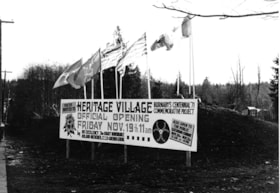
Sign for Heritage Village official opening
https://search.heritageburnaby.ca/link/museumdescription13633
- Repository
- Burnaby Village Museum
- Date
- November 1971
- Collection/Fonds
- Donald Copan collection
- Description Level
- Item
- Physical Description
- 1 photograph : b&w ; 8.9 x 12.7 cm
- Scope and Content
- Photograph of sign for the "Heritage Village Official Opening Friday November 19th 11am". The sign is located on Canada Way and Deer Lake Avenue. Flags flying over the sign include; BC Centennial; British Columbia and Canada flags.
- Repository
- Burnaby Village Museum
- Collection/Fonds
- Donald Copan collection
- Series
- Copan album series
- Description Level
- Item
- Physical Description
- 1 photograph : b&w ; 8.9 x 12.7 cm
- Scope and Content
- Photograph of sign for the "Heritage Village Official Opening Friday November 19th 11am". The sign is located on Canada Way and Deer Lake Avenue. Flags flying over the sign include; BC Centennial; British Columbia and Canada flags.
- Subjects
- Events - Openings
- Advertising Medium - Signs and Signboards
- Symbols - Flags
- Ceremonial Artifacts - Flags
- Names
- Burnaby Village Museum
- Accession Code
- BV005.54.528
- Access Restriction
- No restrictions
- Reproduction Restriction
- May be restricted by third party rights
- Date
- November 1971
- Media Type
- Photograph
- Scan Resolution
- 600
- Scan Date
- August 11, 2020
- Scale
- 100
- Notes
- Title based on contents of photograph
Images

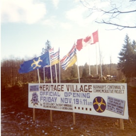
Sign for Heritage Village official opening
https://search.heritageburnaby.ca/link/museumdescription13637
- Repository
- Burnaby Village Museum
- Date
- November 1971
- Collection/Fonds
- Donald Copan collection
- Description Level
- Item
- Physical Description
- 1 photograph : col. ; 8.9 x 8.9 cm
- Scope and Content
- Photograph of sign for the "Heritage Village Official Opening Friday November 19th 11am". The sign is located on Canada Way and Deer Lake Avenue. Flags flying over the sign include; BC Centennial; British Columbia and Canada flags.
- Repository
- Burnaby Village Museum
- Collection/Fonds
- Donald Copan collection
- Series
- Copan album series
- Description Level
- Item
- Physical Description
- 1 photograph : col. ; 8.9 x 8.9 cm
- Scope and Content
- Photograph of sign for the "Heritage Village Official Opening Friday November 19th 11am". The sign is located on Canada Way and Deer Lake Avenue. Flags flying over the sign include; BC Centennial; British Columbia and Canada flags.
- Subjects
- Events - Openings
- Advertising Medium - Signs and Signboards
- Symbols - Flags
- Ceremonial Artifacts - Flags
- Names
- Burnaby Village Museum
- Accession Code
- BV005.54.532
- Access Restriction
- No restrictions
- Reproduction Restriction
- May be restricted by third party rights
- Date
- November 1971
- Media Type
- Photograph
- Scan Resolution
- 600
- Scan Date
- August 11, 2020
- Scale
- 100
- Notes
- Title based on contents of photograph
Images


Burnaby Lake rowing course dredging
https://search.heritageburnaby.ca/link/archivedescription38303
- Repository
- City of Burnaby Archives
- Date
- 1971
- Collection/Fonds
- Burnaby Historical Society fonds
- Description Level
- Item
- Physical Description
- 1 photograph : col. ; 12.5 x 18 cm
- Scope and Content
- Aerial photograph of the Burnaby Lake rowing course being dredged in 1971, in preparation for the 1973 Canada Summer Games.
- Repository
- City of Burnaby Archives
- Date
- 1971
- Collection/Fonds
- Burnaby Historical Society fonds
- Subseries
- Photographs subseries
- Physical Description
- 1 photograph : col. ; 12.5 x 18 cm
- Description Level
- Item
- Record No.
- 400-001
- Access Restriction
- No restrictions
- Reproduction Restriction
- Reproduce for fair dealing purposes only
- Accession Number
- BHS2007-04
- Scope and Content
- Aerial photograph of the Burnaby Lake rowing course being dredged in 1971, in preparation for the 1973 Canada Summer Games.
- Media Type
- Photograph
- Notes
- Title based on contents of photograph
- Geographic Access
- Roberts Street
- Burnaby Lake
- Street Address
- 6871 Roberts Street
- Historic Neighbourhood
- Burnaby Lake (Historic Neighbourhood)
- Planning Study Area
- Burnaby Lake Area
Images


Closed ’Til Further Notice
https://search.heritageburnaby.ca/link/archivedescription95130
- Repository
- City of Burnaby Archives
- Date
- April 27, 2020
- Collection/Fonds
- Burnaby Photographic Society fonds
- Description Level
- Item
- Physical Description
- 1 photograph (tiff)
- Scope and Content
- Photograph of the Shadbolt Centre for the Arts' digital marquee on Canada Way, at night. The marquee, which reads "Closed", is brightly illuminated in the dark.
- Repository
- City of Burnaby Archives
- Date
- April 27, 2020
- Collection/Fonds
- Burnaby Photographic Society fonds
- Physical Description
- 1 photograph (tiff)
- Description Level
- Item
- Record No.
- 623-048
- Access Restriction
- No restrictions
- Reproduction Restriction
- Reproduce for fair dealing purposes only
- Accession Number
- 2020-10
- Scope and Content
- Photograph of the Shadbolt Centre for the Arts' digital marquee on Canada Way, at night. The marquee, which reads "Closed", is brightly illuminated in the dark.
- Media Type
- Photograph
- Photographer
- Jerome, Ron
- Notes
- Transcribed title
- Geographic Access
- Deer Lake Avenue
- Street Address
- 6450 Deer Lake Avenue
- Historic Neighbourhood
- Burnaby Lake (Historic Neighbourhood)
- Planning Study Area
- Douglas-Gilpin Area
Images

![The Fair Haven, [between 1950 and 1957] thumbnail](/media/Hpo/_Data/_Archives_Images/_Unrestricted/251/305-001.jpg?width=280)
The Fair Haven
https://search.heritageburnaby.ca/link/archivedescription36597
- Repository
- City of Burnaby Archives
- Date
- [between 1950 and 1957]
- Collection/Fonds
- Burnaby Historical Society fonds
- Description Level
- Item
- Physical Description
- 1 photograph : col. postcard ; 9 x 14 cm
- Scope and Content
- Aerial photographic postcard of "the Fair Haven," a group of United Church homes for Senior Citizens. The road in the foreground is Rumble Street, and the long road to the right is Sussex Avenue. The small forest behind "the Fair Haven" is the David Gary Park.
- Repository
- City of Burnaby Archives
- Date
- [between 1950 and 1957]
- Collection/Fonds
- Burnaby Historical Society fonds
- Subseries
- Vera Jackson Pel subseries
- Physical Description
- 1 photograph : col. postcard ; 9 x 14 cm
- Description Level
- Item
- Record No.
- 305-001
- Access Restriction
- No restrictions
- Reproduction Restriction
- Reproduce for fair dealing purposes only
- Accession Number
- BHS1992-46
- Scope and Content
- Aerial photographic postcard of "the Fair Haven," a group of United Church homes for Senior Citizens. The road in the foreground is Rumble Street, and the long road to the right is Sussex Avenue. The small forest behind "the Fair Haven" is the David Gary Park.
- Subjects
- Aerial Photographs
- Documentary Artifacts - Postcards
- Buildings - Residential - Seniors Housing
- Names
- Fair Haven
- Media Type
- Photograph
- Notes
- Typewritten note on verso of postcard reads: "AERIAL VIEW/ 'The Fairhaven', Burnaby BC / United Church Homes for Senior Citizens / 4341 Rumble St., Burnaby, BC"
- Handwritten note on verso of postcard reads: ""The road in the foreground is Rumble Street. The long road to the right is Sussex Avenue. The road, going up, on the left, barely visible is McKay Avenue = lower corner. Behind Fair Haven is the future David Gary Park cleared in the late 1950's - then more trees were felled in October 1962 with Hurricane Freda (blown over, uprooted trees) that left the park as it is today in 1993. The top row of little (5) white cottages were moved from the N.W. corner of Willingdon and Kingsway where Old Orchard Mall is now - they were part of Old Orchard Auto Villas, the first Fair Havens. Note: All cottages on right side of Lodge have been moved to Vancouver Island in 1991 for Motel units - by barge."
- Printed on verso of postcard: "Traveltime product, made in Vancouver, Canada, by Grant-Mann Lithographers Ltd."
- Geographic Access
- Rumble Street
- Street Address
- 4341 Rumble Street
- Historic Neighbourhood
- Alta-Vista (Historic Neighbourhood)
- Planning Study Area
- Sussex-Nelson Area
Images
![The Fair Haven, [between 1950 and 1957] thumbnail](/media/Hpo/_Data/_Archives_Images/_Unrestricted/251/305-001.jpg)
![Gordon Presbyterian Church Refreshment Tent, [1912] (date of original), copied 1987 thumbnail](/media/hpo/_Data/_Archives_Images/_Unrestricted/126/193-001.jpg?width=280)
Gordon Presbyterian Church Refreshment Tent
https://search.heritageburnaby.ca/link/archivedescription35100
- Repository
- City of Burnaby Archives
- Date
- [1912] (date of original), copied 1987
- Collection/Fonds
- Burnaby Historical Society fonds
- Description Level
- Item
- Physical Description
- 1 photograph : b&w ; 8.8 x 12.5 cm print
- Scope and Content
- Photograph of the exterior of the Gordon Presbyterian Church refreshment tent at the Central Park Agricultural Exhibition. Banners above the door of the tent read, "Gordon Presby Church Refreshments" and "Hot Meals." Other banners and penants read, "God Save the King" and "Canada." Nine women an…
- Repository
- City of Burnaby Archives
- Date
- [1912] (date of original), copied 1987
- Collection/Fonds
- Burnaby Historical Society fonds
- Subseries
- Gordon Presbyterian Church subseries
- Physical Description
- 1 photograph : b&w ; 8.8 x 12.5 cm print
- Description Level
- Item
- Record No.
- 193-001
- Access Restriction
- No restrictions
- Reproduction Restriction
- No known restrictions
- Accession Number
- BHS1987-02
- Scope and Content
- Photograph of the exterior of the Gordon Presbyterian Church refreshment tent at the Central Park Agricultural Exhibition. Banners above the door of the tent read, "Gordon Presby Church Refreshments" and "Hot Meals." Other banners and penants read, "God Save the King" and "Canada." Nine women and two men are standing outside the tent. The women are wearing aprons. There is an automobile parked on the right side of the photograph.
- Subjects
- Buildings - Commercial - Restaurants
- Advertising Medium - Signs and Signboards
- Structures - Tents
- Media Type
- Photograph
- Notes
- Title based on contents of photograph
- Geographic Access
- Central Park
- Imperial Street
- Street Address
- 3883 Imperial Street
- Historic Neighbourhood
- Central Park (Historic Neighbourhood)
- Planning Study Area
- Maywood Area
Images
![Gordon Presbyterian Church Refreshment Tent, [1912] (date of original), copied 1987 thumbnail](/media/hpo/_Data/_Archives_Images/_Unrestricted/126/193-001.jpg)
![Gordon Presbyterian Church Refreshment Tent, [1912] (date of original), copied 1987 thumbnail](/media/hpo/_Data/_Archives_Images/_Unrestricted/126/193-002.jpg?width=280)
Gordon Presbyterian Church Refreshment Tent
https://search.heritageburnaby.ca/link/archivedescription35101
- Repository
- City of Burnaby Archives
- Date
- [1912] (date of original), copied 1987
- Collection/Fonds
- Burnaby Historical Society fonds
- Description Level
- Item
- Physical Description
- 1 photograph : b&w ; 8.7 x 12.4 cm print
- Scope and Content
- Photograph of the exterior of the Gordon Presbyterian Church refreshment tent at the Central Park Agricultural Exhibition. A sign above the door of the tent reads, "Gordon Presby Church Refreshments." Eight women and two men are standing outside the tent. The women are wearing aprons. Pennants …
- Repository
- City of Burnaby Archives
- Date
- [1912] (date of original), copied 1987
- Collection/Fonds
- Burnaby Historical Society fonds
- Subseries
- Gordon Presbyterian Church subseries
- Physical Description
- 1 photograph : b&w ; 8.7 x 12.4 cm print
- Description Level
- Item
- Record No.
- 193-002
- Access Restriction
- No restrictions
- Reproduction Restriction
- No known restrictions
- Accession Number
- BHS1987-02
- Scope and Content
- Photograph of the exterior of the Gordon Presbyterian Church refreshment tent at the Central Park Agricultural Exhibition. A sign above the door of the tent reads, "Gordon Presby Church Refreshments." Eight women and two men are standing outside the tent. The women are wearing aprons. Pennants on the tent read, "Canada."
- Subjects
- Buildings - Commercial - Restaurants
- Advertising Medium - Signs and Signboards
- Structures - Tents
- Media Type
- Photograph
- Notes
- Title based on contents of photograph
- Geographic Access
- Central Park
- Imperial Street
- Street Address
- 3883 Imperial Street
- Historic Neighbourhood
- Central Park (Historic Neighbourhood)
- Planning Study Area
- Maywood Area
Images
![Gordon Presbyterian Church Refreshment Tent, [1912] (date of original), copied 1987 thumbnail](/media/hpo/_Data/_Archives_Images/_Unrestricted/126/193-002.jpg)
![Highway Improvement Project signage, [1972] thumbnail](/media/hpo/_Data/_Archives_Images/_Unrestricted/480/480-280.jpg?width=280)
Highway Improvement Project signage
https://search.heritageburnaby.ca/link/archivedescription45385
- Repository
- City of Burnaby Archives
- Date
- [1972]
- Collection/Fonds
- Columbian Newspaper collection
- Description Level
- Item
- Physical Description
- 1 photograph : b&w ; 14 x 21 cm
- Scope and Content
- Photograph of Highway Improvement Project signage (developed by the British Columbian Government under W.A.C. Bennett) along the Trans Canada Highway.
- Repository
- City of Burnaby Archives
- Date
- [1972]
- Collection/Fonds
- Columbian Newspaper collection
- Physical Description
- 1 photograph : b&w ; 14 x 21 cm
- Description Level
- Item
- Record No.
- 480-280
- Access Restriction
- No restrictions
- Reproduction Restriction
- No restrictions
- Accession Number
- 2003-02
- Scope and Content
- Photograph of Highway Improvement Project signage (developed by the British Columbian Government under W.A.C. Bennett) along the Trans Canada Highway.
- Media Type
- Photograph
- Photographer
- King, Basil
- Notes
- Title based on contents of photograph
Images
![Highway Improvement Project signage, [1972] thumbnail](/media/hpo/_Data/_Archives_Images/_Unrestricted/480/480-280.jpg)
![Lenkurt Electric Company, [1957] thumbnail](/media/Hpo/_Data/_Archives_Images/_Unrestricted/001/099-001.jpg?width=280)
Lenkurt Electric Company
https://search.heritageburnaby.ca/link/archivedescription34690
- Repository
- City of Burnaby Archives
- Date
- [1957]
- Collection/Fonds
- Burnaby Historical Society fonds
- Description Level
- Item
- Physical Description
- 1 photograph : b&w ; 20.3 x 25.3 cm
- Scope and Content
- Photograph of aerial view of the Lenkurt Electric Company at 6960 Lougheed Highway (later renumbered 7018 Lougheed Highway). A sign on the top of the building reads, "Lenkurt." An information sheet from the Company Relation Division of Lenkurt attached to the back of the photograph reads, "Aerial…
- Repository
- City of Burnaby Archives
- Date
- [1957]
- Collection/Fonds
- Burnaby Historical Society fonds
- Subseries
- Photographs subseries
- Physical Description
- 1 photograph : b&w ; 20.3 x 25.3 cm
- Description Level
- Item
- Record No.
- 099-001
- Access Restriction
- No restrictions
- Reproduction Restriction
- Reproduce for fair dealing purposes only
- Accession Number
- BHS2007-04
- Scope and Content
- Photograph of aerial view of the Lenkurt Electric Company at 6960 Lougheed Highway (later renumbered 7018 Lougheed Highway). A sign on the top of the building reads, "Lenkurt." An information sheet from the Company Relation Division of Lenkurt attached to the back of the photograph reads, "Aerial view of a 34,000 square foot building including a 19,000 square foot extension to the existing 15,000 square foot plant of Lenkurt Electric Co. of Canada Ltd. in North Burnaby, B.C., as at May 10th, 1957. / The building is situated on 20 acres of land and faces north onto Lougheed Highway."
- Names
- Lenkurt Electric Company
- Media Type
- Photograph
- Photographer
- Commercial Illustrators Industrial Photographers
- Notes
- Title based on contents of photograph
- Stamp and annotation on back of photograph reads, "TA. 8817 / Commerical Illustrators / Industrial Photographers / 601 Denman St., Vancouver 5, B.C. / File No. 1080-1"
- Geographic Access
- Lougheed Highway
- Street Address
- 7018 Lougheed Highway
- Historic Neighbourhood
- Lozells (Historic Neighbourhood)
- Planning Study Area
- Government Road Area
Images
![Lenkurt Electric Company, [1957] thumbnail](/media/Hpo/_Data/_Archives_Images/_Unrestricted/001/099-001.jpg)