More like 'Burnaby creek conservationists'
Narrow Results By
Person / Organization
- Baldwin, Ruth 1
- Barnet Mill 1
- BC Society of Model Engineers (BCSME) 1
- British Columbia Electric Railway Company 1
- Brownlee, James Harrison 1
- Burnaby Art Gallery 1
- Burnaby Lake Rowing Pavilion 1
- Burnaby Mountain Park 1
- Burnaby Village Museum 1
- Central Park 2
- Central Park Pitch 'n Putt 1
- Clinton Elementary School 1
![Speycasting at Deer Lake Beach, [2005] thumbnail](/media/hpo/_Data/_Archives_Images/_Unrestricted/535/535-2169-2.jpg?width=280)
Speycasting at Deer Lake Beach
https://search.heritageburnaby.ca/link/archivedescription96547
- Repository
- City of Burnaby Archives
- Date
- [2005]
- Collection/Fonds
- Burnaby NewsLeader photograph collection
- Description Level
- File
- Physical Description
- 2 photographs (tiff) : col.
- Scope and Content
- File contains photographs of Sandy Hamilton speycasting (a style of fly fishing) at Deer Lake Beach. Photographs include a close-up of Hamilton and Hamilton casting on to Deer Lake, with the lake, houses, and towers visible in the background.
- Repository
- City of Burnaby Archives
- Date
- [2005]
- Collection/Fonds
- Burnaby NewsLeader photograph collection
- Physical Description
- 2 photographs (tiff) : col.
- Description Level
- File
- Record No.
- 535-2169
- Access Restriction
- No restrictions
- Reproduction Restriction
- No restrictions
- Accession Number
- 2018-12
- Scope and Content
- File contains photographs of Sandy Hamilton speycasting (a style of fly fishing) at Deer Lake Beach. Photographs include a close-up of Hamilton and Hamilton casting on to Deer Lake, with the lake, houses, and towers visible in the background.
- Media Type
- Photograph
- Photographer
- Bartel, Mario
- Notes
- Title based on caption
- Collected by editorial for use in a March 2005 issue of the Burnaby NewsLeader
- Caption from metadata: "Sandy Hamilton works on his speycasting technique at Deer Lake beach on Saturday. Speycasting is a two-handed style of fly fishing that was developed on the Spey River in Scotland."
- Geographic Access
- Deer Lake
- Deer Lake Park
- Historic Neighbourhood
- Burnaby Lake (Historic Neighbourhood)
- Planning Study Area
- Morley-Buckingham Area
Images
![Speycasting at Deer Lake Beach, [2005] thumbnail](/media/hpo/_Data/_Archives_Images/_Unrestricted/535/535-2169-2.jpg)
Still Creek Flora
https://search.heritageburnaby.ca/link/archivedescription91703
- Repository
- City of Burnaby Archives
- Date
- 1991
- Collection/Fonds
- Doreen Lawson fonds
- Description Level
- File
- Physical Description
- 6 photographs : col. slides ; 35 mm
- Scope and Content
- File consists photographs of colourful flora around Still Creek. Flower species have not been identified.
- Repository
- City of Burnaby Archives
- Date
- 1991
- Collection/Fonds
- Doreen Lawson fonds
- Physical Description
- 6 photographs : col. slides ; 35 mm
- Description Level
- File
- Record No.
- 618-021
- Access Restriction
- No restrictions
- Reproduction Restriction
- No restrictions
- Accession Number
- 2015-15
- Scope and Content
- File consists photographs of colourful flora around Still Creek. Flower species have not been identified.
- Subjects
- Geographic Features - Lakes and Ponds
- Animals - Birds
- Plants - Trees
- Natural Phenomena - Snow
- Media Type
- Photograph
- Photographer
- Lawson, Doreen A.
- Notes
- Transcribed title
- Title transcribed from slide sheet
- Note purple and blue ink on original slide sheet read: "Still Creek / Flora / 1991"
- Geographic Access
- Still Creek
- Historic Neighbourhood
- Burnaby Lake (Historic Neighbourhood)
Images
![Burnaby rivers, [2002] thumbnail](/media/hpo/_Data/_Archives_Images/_Unrestricted/535/535-2800-1.jpg?width=280)
Burnaby rivers
https://search.heritageburnaby.ca/link/archivedescription97440
- Repository
- City of Burnaby Archives
- Date
- [2002]
- Collection/Fonds
- Burnaby NewsLeader photograph collection
- Description Level
- File
- Physical Description
- 4 photographs (tiff) : col.
- Scope and Content
- File contains photographs of people with Burnaby rivers and creeks. Photographs depict BCIT river conservationist Mark Angelo posing in Deer Lake Brook by Burnaby Village Museum, and Lorna Johnson, Gordie Cook, and Jack McAfee enjoying Fraser Foreshore Park by the Fraser River.
- Repository
- City of Burnaby Archives
- Date
- [2002]
- Collection/Fonds
- Burnaby NewsLeader photograph collection
- Physical Description
- 4 photographs (tiff) : col.
- Description Level
- File
- Record No.
- 535-2800
- Access Restriction
- No restrictions
- Reproduction Restriction
- No restrictions
- Accession Number
- 2018-12
- Scope and Content
- File contains photographs of people with Burnaby rivers and creeks. Photographs depict BCIT river conservationist Mark Angelo posing in Deer Lake Brook by Burnaby Village Museum, and Lorna Johnson, Gordie Cook, and Jack McAfee enjoying Fraser Foreshore Park by the Fraser River.
- Media Type
- Photograph
- Photographer
- Bartel, Mario
- Notes
- Title based on caption
- Collected by editorial for use in a September 2002 issue of the Burnaby NewsLeader
- Caption from metadata for 535-2800-1 and 535-2800-2: "Mark Angelo, of BCIT, who's made it his mission to save and preserve Burnaby's rivers and creeks, says he's particularly proud of Deer Lake Brook, as it babbles through Burnaby Village Museum, on its way to Burnaby Lake."
- Caption from metadata for 535-2800-3: "Lorna Johnson hits a tennis ball out into the Fraser River at Fraser Foreshore Park, to her dog, Keiko."
- Caption from metadata for 535-2800-4: "Gordie Cook and Jack McAfee shoot the breeze and enjoy the sunshine along the Fraser River, at Fraser Foreshore Park in Burnaby."
- Geographic Access
- Deer Lake Brook
- Burnaby Fraser Foreshore Park
- Fraser River
- Historic Neighbourhood
- Fraser Arm (Historic Neighbourhood)
- Burnaby Lake (Historic Neighbourhood)
- Planning Study Area
- Morley-Buckingham Area
- Big Bend Area
Images
![Burnaby rivers, [2002] thumbnail](/media/hpo/_Data/_Archives_Images/_Unrestricted/535/535-2800-1.jpg)
![David Doyle, [2002] thumbnail](/media/hpo/_Data/_Archives_Images/_Unrestricted/535/535-1981-1.jpg?width=280)
David Doyle
https://search.heritageburnaby.ca/link/archivedescription96298
- Repository
- City of Burnaby Archives
- Date
- [2002]
- Collection/Fonds
- Burnaby NewsLeader photograph collection
- Description Level
- File
- Physical Description
- 2 photographs (tiff) : col.
- Scope and Content
- File contains photographs of David Doyle on Burnaby Mountain. Photographs depict Doyle using a GPS to map streams and watercourses to gather environmental data ahead of the UniverCity development by SFU on Burnaby Mountain.
- Repository
- City of Burnaby Archives
- Date
- [2002]
- Collection/Fonds
- Burnaby NewsLeader photograph collection
- Physical Description
- 2 photographs (tiff) : col.
- Description Level
- File
- Record No.
- 535-1981
- Access Restriction
- No restrictions
- Reproduction Restriction
- No restrictions
- Accession Number
- 2018-12
- Scope and Content
- File contains photographs of David Doyle on Burnaby Mountain. Photographs depict Doyle using a GPS to map streams and watercourses to gather environmental data ahead of the UniverCity development by SFU on Burnaby Mountain.
- Subjects
- Geographic Features - Streams
- Names
- Simon Fraser University
- Media Type
- Photograph
- Photographer
- Bartel, Mario
- Notes
- Title based on caption
- Collected by editorial for use in a February 2002 issue of the Burnaby NewsLeader
- Caption from metadata: "David Doyle uses a satellite Global Positioning System to map streams and watercourses on Burnaby Mountain, in preparation for the Univer-City development around Simon Fraser University. The data he accumulates will be used by the Stoney Creek Environmental Committee to guage the impact construction may have on water quality and fish habitats."
- Geographic Access
- Burnaby Mountain Conservation Area
- Planning Study Area
- Burnaby Mountain Area
Images
![David Doyle, [2002] thumbnail](/media/hpo/_Data/_Archives_Images/_Unrestricted/535/535-1981-1.jpg)
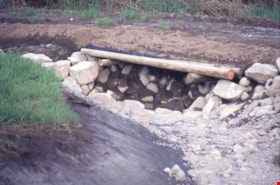
Beaver Creek - Royal Oak Avenue
https://search.heritageburnaby.ca/link/archivedescription91582
- Repository
- City of Burnaby Archives
- Date
- August 9, 1996
- Collection/Fonds
- Doreen Lawson fonds
- Description Level
- File
- Physical Description
- 13 photographs : col. slides ; 35 mm
- Scope and Content
- File consists of photographs of Beaver Creek and Royal Oak Avenue taken during the Royal Oak Avenue Realignment project.
- Repository
- City of Burnaby Archives
- Date
- August 9, 1996
- Collection/Fonds
- Doreen Lawson fonds
- Physical Description
- 13 photographs : col. slides ; 35 mm
- Description Level
- File
- Record No.
- 605-015
- Access Restriction
- No restrictions
- Reproduction Restriction
- No restrictions
- Accession Number
- 2003-30
- Scope and Content
- File consists of photographs of Beaver Creek and Royal Oak Avenue taken during the Royal Oak Avenue Realignment project.
- Subjects
- Geographic Features - Creeks
- Names
- Lawson, Doreen A.
- Media Type
- Photograph
- Photographer
- Lawson, Doreen A.
- Notes
- Title based on contents of photographs
- Geographic Access
- Deer Lake Park
- Historic Neighbourhood
- Burnaby Lake (Historic Neighbourhood)
- Planning Study Area
- Oakalla Area
Images


Byrne Creek
https://search.heritageburnaby.ca/link/archivedescription91705
- Repository
- City of Burnaby Archives
- Date
- March 25, 1993
- Collection/Fonds
- Doreen Lawson fonds
- Description Level
- File
- Physical Description
- 40 photographs : col. slides ; 35 mm
- Scope and Content
- File consists of photographs of Byrne Creek. The photographs depict the creek prior to clean-up with the water and paths littered with debris. Also included in the file are photographs of an unidentified man pulling a dead fish from the creek.
- Repository
- City of Burnaby Archives
- Date
- March 25, 1993
- Collection/Fonds
- Doreen Lawson fonds
- Physical Description
- 40 photographs : col. slides ; 35 mm
- Description Level
- File
- Record No.
- 618-023
- Access Restriction
- No restrictions
- Reproduction Restriction
- No restrictions
- Accession Number
- 2015-15
- Scope and Content
- File consists of photographs of Byrne Creek. The photographs depict the creek prior to clean-up with the water and paths littered with debris. Also included in the file are photographs of an unidentified man pulling a dead fish from the creek.
- Media Type
- Photograph
- Photographer
- Lawson, Doreen A.
- Glover, Ken
- Notes
- Transcribed title
- Title transcribed from label on slide sheets
- Note in black ink on recto of slide frames 618-023-11, 618-023-12, 618-023-14, 618-023-33, and 618-023-40 reads: "Ken Glover / BOB"
- Geographic Access
- Byrne Creek
- Historic Neighbourhood
- Edmonds (Historic Neighbourhood)
- Planning Study Area
- Stride Avenue Area
Images

![Clinton Elementary School students releasing salmon in Byrne Creek, [1999] thumbnail](/media/hpo/_Data/_Archives_Images/_Unrestricted/535/535-3168-1.jpg?width=280)
Clinton Elementary School students releasing salmon in Byrne Creek
https://search.heritageburnaby.ca/link/archivedescription98088
- Repository
- City of Burnaby Archives
- Date
- [1999]
- Collection/Fonds
- Burnaby NewsLeader photograph collection
- Description Level
- File
- Physical Description
- 2 photographs (tiff) : col.
- Scope and Content
- File contains photographs of Clinton Elementary School students releasing salmon fingerlings into Byrne Creek.
- Repository
- City of Burnaby Archives
- Date
- [1999]
- Collection/Fonds
- Burnaby NewsLeader photograph collection
- Physical Description
- 2 photographs (tiff) : col.
- Description Level
- File
- Record No.
- 535-3168
- Access Restriction
- No restrictions
- Reproduction Restriction
- No restrictions
- Accession Number
- 2018-12
- Scope and Content
- File contains photographs of Clinton Elementary School students releasing salmon fingerlings into Byrne Creek.
- Media Type
- Photograph
- Photographer
- Bartel, Mario
- Notes
- Title based on caption
- Collected by editorial for use in a May 1999 issue of the Burnaby NewsLeader
- Caption from metadata for 535-3168-1: "Chantalle Pike, Matthew Jowit and Tyler Seymour, from Clinton Elementary School, release some of the 5,000 year-old Coho salmon into Byrne Creek. The fingerlings, each weighing about 20 grams, were raised at the Bell-Irving Hatchery in Maple Ridge and they will spend a short time in the creek before making their way out to sea."
- Geographic Access
- Byrne Creek
- Historic Neighbourhood
- Edmonds (Historic Neighbourhood)
- Planning Study Area
- Stride Avenue Area
Images
![Clinton Elementary School students releasing salmon in Byrne Creek, [1999] thumbnail](/media/hpo/_Data/_Archives_Images/_Unrestricted/535/535-3168-1.jpg)
![Fish release for BC Rivers Week, [2000] thumbnail](/media/hpo/_Data/_Archives_Images/_Unrestricted/535/535-2700-1.jpg?width=280)
Fish release for BC Rivers Week
https://search.heritageburnaby.ca/link/archivedescription97303
- Repository
- City of Burnaby Archives
- Date
- [2000]
- Collection/Fonds
- Burnaby NewsLeader photograph collection
- Description Level
- File
- Physical Description
- 2 photographs (tiff) : col.
- Scope and Content
- File contains photographs of the fish release kickoff event for BC Rivers Week. Photographs depict Morley Rempel, a fish culturist at the Fraser Valley Trout Hatchery, moving trout into a bucket with a net and Environment Minister Joan Sawicki and the chairman of the Outdoor Recreation Council of B…
- Repository
- City of Burnaby Archives
- Date
- [2000]
- Collection/Fonds
- Burnaby NewsLeader photograph collection
- Physical Description
- 2 photographs (tiff) : col.
- Description Level
- File
- Record No.
- 535-2700
- Access Restriction
- No restrictions
- Reproduction Restriction
- No restrictions
- Accession Number
- 2018-12
- Scope and Content
- File contains photographs of the fish release kickoff event for BC Rivers Week. Photographs depict Morley Rempel, a fish culturist at the Fraser Valley Trout Hatchery, moving trout into a bucket with a net and Environment Minister Joan Sawicki and the chairman of the Outdoor Recreation Council of BC, Mark Angelo, releasing the trout in Guichon Creek.
- Names
- Sawicki, Joan
- Media Type
- Photograph
- Photographer
- Bartel, Mario
- Notes
- Title based on caption
- Collected by editorial for use in a September 2000 issue of the Burnaby NewsLeader
- Caption from metadata for 535-2700-1: "Morley Rempel, a fish culturist at the Fraser Valley Trout Hatchery, prepares the first cutthroat trout fingerlings to be released into Guichon Creek, a kickoff for BC Rivers Week."
- Caption from metadata for 535-2700-2: "Environment Minister Joan Sawicki and the chairman of the Outdoor Recreation Council of BC, Mark Angelo, release the first trout fingerlings into Guichon Creek, to celebrate its rehabilitation, and to launch BC Rivers Week."
- Planning Study Area
- Douglas-Gilpin Area
Images
![Fish release for BC Rivers Week, [2000] thumbnail](/media/hpo/_Data/_Archives_Images/_Unrestricted/535/535-2700-1.jpg)
Marine Way
https://search.heritageburnaby.ca/link/archivedescription93716
- Repository
- City of Burnaby Archives
- Date
- 1987
- Collection/Fonds
- Grover, Elliott & Co. Ltd. fonds
- Description Level
- File
- Physical Description
- 24 photographs : col. negatives ; 35 mm
- Scope and Content
- Photographs of an undeveloped property along Marine Way. Property is located adjacent to railway tracks and a creek.
- Repository
- City of Burnaby Archives
- Date
- 1987
- Collection/Fonds
- Grover, Elliott & Co. Ltd. fonds
- Physical Description
- 24 photographs : col. negatives ; 35 mm
- Description Level
- File
- Record No.
- 622-005
- Access Restriction
- No restrictions
- Reproduction Restriction
- No restrictions
- Accession Number
- 2017-39
- Scope and Content
- Photographs of an undeveloped property along Marine Way. Property is located adjacent to railway tracks and a creek.
- Media Type
- Photograph
- Notes
- Transcribed title
- Title transcribed from original print envelope
- File no. 87-297-B
- Geographic Access
- Marine Way
- Historic Neighbourhood
- Fraser Arm (Historic Neighbourhood)
- Planning Study Area
- Big Bend Area
![Salmon Send Off, [2002] thumbnail](/media/hpo/_Data/_Archives_Images/_Unrestricted/535/535-2351-2.jpg?width=280)
Salmon Send Off
https://search.heritageburnaby.ca/link/archivedescription96752
- Repository
- City of Burnaby Archives
- Date
- [2002]
- Collection/Fonds
- Burnaby NewsLeader photograph collection
- Description Level
- File
- Physical Description
- 2 photographs (tiff) : col.
- Scope and Content
- File contains photographs of the annual Salmon Send Off at Stoney Creek. Photographs depict a group of students (Cristina Leighton, Sara Ellis, Megan Lyons, Tommy Monkman, Alicia Yeung, and Ryan Tyson) who attended the first Salmon Send Off 12 years prior with salmon they are about to release, and …
- Repository
- City of Burnaby Archives
- Date
- [2002]
- Collection/Fonds
- Burnaby NewsLeader photograph collection
- Physical Description
- 2 photographs (tiff) : col.
- Description Level
- File
- Record No.
- 535-2351
- Access Restriction
- No restrictions
- Reproduction Restriction
- No restrictions
- Accession Number
- 2018-12
- Scope and Content
- File contains photographs of the annual Salmon Send Off at Stoney Creek. Photographs depict a group of students (Cristina Leighton, Sara Ellis, Megan Lyons, Tommy Monkman, Alicia Yeung, and Ryan Tyson) who attended the first Salmon Send Off 12 years prior with salmon they are about to release, and Maurice Coulter-Boisvert, of the Federal Department of Fisheries and Oceans, scooping up salmon for release as a crowd looks on in the background.
- Media Type
- Photograph
- Photographer
- Bartel, Mario
- Notes
- Title based on caption
- Collected by editorial for use in a May 2002 issue of the Burnaby NewsLeader
- Caption from metadata: "Cristina Leighton, Sara Ellis, Megan Lyons, Tommy Monkman, Alicia Yeung and Ryan Tyson check out the 14-month old Coho smolts they're about to release into Burnaby's Stoney Creek, at the annual Salmon Send Off, on Saturday. The group were all kindergarten students at the first Salmon Send Off 12 years ago, and, like the little fish, they decided to return to do it again to celebrate their graduation from Grade 12 at Burnaby Mountain Secondary."
- Caption from metadata for 535-2351-2: "Maurice Coulter-Boisvert, of the Federal Department of Fisheries and Oceans, scoops up 14 month-old Coho smolts to be released into Burnaby's Stoney Creek, at the annual Salmon Send Off on Saturday. The smolts, raised at the Kanaka Creek hatchery in Maple Ridge, will begin their journey to the ocean after about a week in the creek."
- Geographic Access
- Stoney Creek
- Historic Neighbourhood
- Burquitlam (Historic Neighbourhood)
- Planning Study Area
- Lyndhurst Area
Images
![Salmon Send Off, [2002] thumbnail](/media/hpo/_Data/_Archives_Images/_Unrestricted/535/535-2351-2.jpg)
![Stoney Creek and SkyTrain construction, [2000] thumbnail](/media/hpo/_Data/_Archives_Images/_Unrestricted/535/535-1595-1.jpg?width=280)
Stoney Creek and SkyTrain construction
https://search.heritageburnaby.ca/link/archivedescription95737
- Repository
- City of Burnaby Archives
- Date
- [2000]
- Collection/Fonds
- Burnaby NewsLeader photograph collection
- Description Level
- File
- Physical Description
- 2 photographs (tiff) : col.
- Scope and Content
- File contains photographs of conservationists observing the effects of the SkyTrain construction on Stoney Creek. In one photograph, a man kneels under an awning to view the culvert and construction work. In the other, a conservationist leans against the railing of a footbridge; the SkyTrain and co…
- Repository
- City of Burnaby Archives
- Date
- [2000]
- Collection/Fonds
- Burnaby NewsLeader photograph collection
- Physical Description
- 2 photographs (tiff) : col.
- Description Level
- File
- Record No.
- 535-1595
- Access Restriction
- No restrictions
- Reproduction Restriction
- No restrictions
- Accession Number
- 2018-12
- Scope and Content
- File contains photographs of conservationists observing the effects of the SkyTrain construction on Stoney Creek. In one photograph, a man kneels under an awning to view the culvert and construction work. In the other, a conservationist leans against the railing of a footbridge; the SkyTrain and construction vehicles and framing are visible in the background.
- Media Type
- Photograph
- Photographer
- Bartel, Mario
- Notes
- Title based on caption
- Collected by editorial for use in a February 2001 issue of the Burnaby NewsLeader
- Caption from metadata for 535-1595-1: "Al Russell checks some of the remedial work done by the Skytrain construction project to protect Stoney Creek. When dirty, contaminated water from the Lougheed Highway was running off into the creek, crews built a culvert into riprap, and laid down absorbent pads to filter contaminents."
- Caption from metadata for 535-1595-2: "Jennifer Hechison surveys Stoney Creek from a footbridge and upgraded path built by the GVRD and conservationists. But the upgrades end below the Skytrain construction project, and Hechison says it's up to the public to remain vigilant that Skytrain live up to its commitments to protect the creek."
- Geographic Access
- Stoney Creek
- Historic Neighbourhood
- Burquitlam (Historic Neighbourhood)
- Planning Study Area
- Lyndhurst Area
Images
![Stoney Creek and SkyTrain construction, [2000] thumbnail](/media/hpo/_Data/_Archives_Images/_Unrestricted/535/535-1595-1.jpg)
6088 Cassie Avenue
https://search.heritageburnaby.ca/link/archivedescription93717
- Repository
- City of Burnaby Archives
- Date
- 1987
- Collection/Fonds
- Grover, Elliott & Co. Ltd. fonds
- Description Level
- File
- Physical Description
- 14 photographs : col. negatives ; 35 mm + 5 photographs : col. ; 10 cm x 15 cm
- Scope and Content
- Photographs of the private residence and garden located at 6088 Cassie Avenue - an address that no longer exists.
- Repository
- City of Burnaby Archives
- Date
- 1987
- Collection/Fonds
- Grover, Elliott & Co. Ltd. fonds
- Physical Description
- 14 photographs : col. negatives ; 35 mm + 5 photographs : col. ; 10 cm x 15 cm
- Description Level
- File
- Record No.
- 622-006
- Access Restriction
- No restrictions
- Reproduction Restriction
- No restrictions
- Accession Number
- 2017-39
- Scope and Content
- Photographs of the private residence and garden located at 6088 Cassie Avenue - an address that no longer exists.
- Media Type
- Photograph
- Notes
- Transcribed title
- Title transcribed from original print envelope
- File no. 87-300-B
- Geographic Access
- Cassie Avenue
- Historic Neighbourhood
- Central Park (Historic Neighbourhood)
- Planning Study Area
- Maywood Area
7837 CA Way Burnaby
https://search.heritageburnaby.ca/link/archivedescription93813
- Repository
- City of Burnaby Archives
- Date
- November 1992
- Collection/Fonds
- Grover, Elliott & Co. Ltd. fonds
- Description Level
- File
- Physical Description
- 48 photographs : col. negatives ; 35 mm + 5 photographs : col. ; 10 cm x 15 cm
- Scope and Content
- Photographs of the residential buildings located at 7837 Canada Way. Buildings include a two-storey blue-shingled house, single-storey addition, and a guest house. File also contains photographs of the Capilano suspension bridge and Capilano Suspension Bridge Park in North Vancouver.
- Repository
- City of Burnaby Archives
- Date
- November 1992
- Collection/Fonds
- Grover, Elliott & Co. Ltd. fonds
- Physical Description
- 48 photographs : col. negatives ; 35 mm + 5 photographs : col. ; 10 cm x 15 cm
- Description Level
- File
- Record No.
- 622-061
- Access Restriction
- No restrictions
- Reproduction Restriction
- No restrictions
- Accession Number
- 2017-39
- Scope and Content
- Photographs of the residential buildings located at 7837 Canada Way. Buildings include a two-storey blue-shingled house, single-storey addition, and a guest house. File also contains photographs of the Capilano suspension bridge and Capilano Suspension Bridge Park in North Vancouver.
- Media Type
- Photograph
- Notes
- Transcribed title
- Title transcribed from envelope photographs were originally housed in
- File no. 92-437-B
- Sticky note adhered to 622-061-9 print reads: "7 / View of the building looking northeast across the site".
- Sticky note adhered to 622-061-13 print reads: "6 / View of the original house and the single storey addition looking north west across the property".
- Sticky note adhered to 622-061-17 print reads: "8 / View northeast across the property from the southeast corner".
- Sticky note adhered to 622-061-21 print reads: "9 / View west from the property along the lane at the south side".
- Sticky note adhered to 622-061-26 reads: "3 / The original house now part of the guest home and the view south along the east property line".
- Sticky note adhered to 622-061-27 reads: "4 / View west along Canada Way [illegible] the subject".
- Sticky note adhered to 622-061-28 reads: "5 / The most recent addition - the single storey L shaped structure at the west end of the guesthouse".
- Sticky note adhere to 622-061-29 reads: "5A / The original house"."
- Photographer identified as "D.E."
- Geographic Access
- Canada Way
- Street Address
- 7837 Canada Way
- Planning Study Area
- Lake City Area
9886 and 9940 Broadway
https://search.heritageburnaby.ca/link/archivedescription94331
- Repository
- City of Burnaby Archives
- Date
- March 1995
- Collection/Fonds
- Grover, Elliott & Co. Ltd. fonds
- Description Level
- File
- Physical Description
- 70 photographs : col. negatives ; 35 mm
- Scope and Content
- Photographs of Broadway, various residential houses and towers, and undeveloped properties at unidentified locations.
- Repository
- City of Burnaby Archives
- Date
- March 1995
- Collection/Fonds
- Grover, Elliott & Co. Ltd. fonds
- Physical Description
- 70 photographs : col. negatives ; 35 mm
- Description Level
- File
- Record No.
- 622-116
- Access Restriction
- No restrictions
- Reproduction Restriction
- No restrictions
- Accession Number
- 2017-39
- Scope and Content
- Photographs of Broadway, various residential houses and towers, and undeveloped properties at unidentified locations.
- Media Type
- Photograph
- Notes
- Transcribed title
- Title transcribed from envelope photographs were originally housed in
- File no. 95-069-B
- Photographer identified as "K.H."
- Geographic Access
- Broadway
- Street Address
- 9886 Broadway
- 9940 Broadway
- Historic Neighbourhood
- Burquitlam (Historic Neighbourhood)
- Planning Study Area
- Lyndhurst Area
![Aftermath of a snowfall, [1999] thumbnail](/media/hpo/_Data/_Archives_Images/_Unrestricted/535/535-3125-1.jpg?width=280)
Aftermath of a snowfall
https://search.heritageburnaby.ca/link/archivedescription98045
- Repository
- City of Burnaby Archives
- Date
- [1999]
- Collection/Fonds
- Burnaby NewsLeader photograph collection
- Description Level
- File
- Physical Description
- 4 photographs (tiff) : b&w
- Scope and Content
- File contains photographs of the aftermath of a large snowfall. Photographs depict an unidentified person moving snow with a wheelbarrow; people shovelling out cars stuck on roads in the snow; and a crane and snow-covered park.
- Repository
- City of Burnaby Archives
- Date
- [1999]
- Collection/Fonds
- Burnaby NewsLeader photograph collection
- Physical Description
- 4 photographs (tiff) : b&w
- Description Level
- File
- Record No.
- 535-3125
- Access Restriction
- No restrictions
- Reproduction Restriction
- No restrictions
- Accession Number
- 2018-12
- Scope and Content
- File contains photographs of the aftermath of a large snowfall. Photographs depict an unidentified person moving snow with a wheelbarrow; people shovelling out cars stuck on roads in the snow; and a crane and snow-covered park.
- Subjects
- Natural Phenomena - Snow
- Geographic Features - Parks
- Geographic Features - Roads
- Transportation - Automobiles
- Media Type
- Photograph
- Notes
- Title based on contents of file
- Collected by editorial for use in a February 1999 issue of the Burnaby NewsLeader
Images
![Aftermath of a snowfall, [1999] thumbnail](/media/hpo/_Data/_Archives_Images/_Unrestricted/535/535-3125-1.jpg)
![Burnaby Fraser Foreshore Park, [2000] thumbnail](/media/hpo/_Data/_Archives_Images/_Unrestricted/535/535-2524-1.jpg?width=280)
Burnaby Fraser Foreshore Park
https://search.heritageburnaby.ca/link/archivedescription96970
- Repository
- City of Burnaby Archives
- Date
- [2000]
- Collection/Fonds
- Burnaby NewsLeader photograph collection
- Description Level
- File
- Physical Description
- 2 photographs (tiff) : col.
- Scope and Content
- File contains photographs of Mayor Doug Drummond and another unidentified person posing by the Fraser River in Burnaby Fraser Foreshore Park.
- Repository
- City of Burnaby Archives
- Date
- [2000]
- Collection/Fonds
- Burnaby NewsLeader photograph collection
- Physical Description
- 2 photographs (tiff) : col.
- Description Level
- File
- Record No.
- 535-2524
- Access Restriction
- No restrictions
- Reproduction Restriction
- No restrictions
- Accession Number
- 2018-12
- Scope and Content
- File contains photographs of Mayor Doug Drummond and another unidentified person posing by the Fraser River in Burnaby Fraser Foreshore Park.
- Media Type
- Photograph
- Notes
- Title based on original file name
- Collected by editorial for use in a June 2000 issue of the Burnaby NewsLeader
- Geographic Access
- Burnaby Fraser Foreshore Park
- Historic Neighbourhood
- Fraser Arm (Historic Neighbourhood)
- Planning Study Area
- Big Bend Area
Images
![Burnaby Fraser Foreshore Park, [2000] thumbnail](/media/hpo/_Data/_Archives_Images/_Unrestricted/535/535-2524-1.jpg)
![Doug Drummond at Barnet Marine Park, [2003] thumbnail](/media/hpo/_Data/_Archives_Images/_Unrestricted/535/535-2277-1.jpg?width=280)
Doug Drummond at Barnet Marine Park
https://search.heritageburnaby.ca/link/archivedescription96655
- Repository
- City of Burnaby Archives
- Date
- [2003]
- Collection/Fonds
- Burnaby NewsLeader photograph collection
- Description Level
- File
- Physical Description
- 2 photographs (tiff) : col.
- Scope and Content
- File contains photographs of former City of Burnaby mayor Doug Drummond at Barnet Marine Park before is improvement and expansion. Photographs depict Drummond standing by the Inlet and walking along the waterfront path with Parks Commissioner Dan Johnston.
- Repository
- City of Burnaby Archives
- Date
- [2003]
- Collection/Fonds
- Burnaby NewsLeader photograph collection
- Physical Description
- 2 photographs (tiff) : col.
- Description Level
- File
- Record No.
- 535-2277
- Access Restriction
- No restrictions
- Reproduction Restriction
- No restrictions
- Accession Number
- 2018-12
- Scope and Content
- File contains photographs of former City of Burnaby mayor Doug Drummond at Barnet Marine Park before is improvement and expansion. Photographs depict Drummond standing by the Inlet and walking along the waterfront path with Parks Commissioner Dan Johnston.
- Subjects
- Geographic Features - Inlets
- Geographic Features - Parks
- Officials - Mayors and Reeves
- Officials - Commissioners
- Media Type
- Photograph
- Photographer
- Bartel, Mario
- Notes
- Title based on caption
- Collected by editorial for use in a March 2003 issue of the Burnaby NewsLeader
- Caption from metadata for 535-2277-1: "Former Burnaby Mayor, Doug Drummond, takes in the view from Barnet Marine Park, which will be expanded to the west, and enhanced with an interpretive centre in the old public works building and a rebuilt wharf reaching into the Burrard Inlet. Improving the park was one of Drummond's goals during his term in office."
- Caption fro metadata for 535-2277-2: "Former Burnaby mayor, Doug Drummond, and the city's parks commissioner, Dan Johnston, stroll along the path at Barnet Marine Park. The park will be expanded to the west, and enhanced with a rebuilt wharf into Burrard Inlet and an interpretive centre in the old public works building. The plan for the park will be the realization of one of Drummond's goals during his term in office."
- Geographic Access
- Barnet Marine Park
- Burrard Inlet
- Historic Neighbourhood
- Barnet (Historic Neighbourhood)
- Planning Study Area
- Burnaby Mountain Area
Images
![Doug Drummond at Barnet Marine Park, [2003] thumbnail](/media/hpo/_Data/_Archives_Images/_Unrestricted/535/535-2277-1.jpg)
Edmonds St + 18th Ave (SW of 16th Street)
https://search.heritageburnaby.ca/link/archivedescription93727
- Repository
- City of Burnaby Archives
- Date
- March 1989
- Collection/Fonds
- Grover, Elliott & Co. Ltd. fonds
- Description Level
- File
- Physical Description
- 14 photographs : col. negatives ; 35 mm
- Scope and Content
- Photographs of the intersections at Edmonds Street and 18th Avenue and Edmonds Street and 16th Avenue and an unidentified residential lane.
- Repository
- City of Burnaby Archives
- Date
- March 1989
- Collection/Fonds
- Grover, Elliott & Co. Ltd. fonds
- Physical Description
- 14 photographs : col. negatives ; 35 mm
- Description Level
- File
- Record No.
- 622-015
- Access Restriction
- No restrictions
- Reproduction Restriction
- No restrictions
- Accession Number
- 2017-39
- Scope and Content
- Photographs of the intersections at Edmonds Street and 18th Avenue and Edmonds Street and 16th Avenue and an unidentified residential lane.
- Media Type
- Photograph
- Notes
- Transcribed title
- Title transcribed from original print envelope
- Photographs 622-015-001 : 622-015-002 depict Edmonds Street and 16th Avenue, facing south
- Photographs 622-015-003 : 622-015-004 depict the view southwest along Edmonds Street
- Photographs 622-015-006 : 622-015-008 depict the view southeast along 16th Street
- Photographs 622-015-009 : 622-015-011 depict the view southwest along 18th Avenue
- Locations were identified using notes on verso of accompanying prints
- Geographic Access
- 18th Avenue
- Edmonds Street
- 16th Avenue
- Historic Neighbourhood
- Edmonds (Historic Neighbourhood)
- Planning Study Area
- Stride Avenue Area
![Trans Canada Trail in North Burnaby, [2000] thumbnail](/media/hpo/_Data/_Archives_Images/_Unrestricted/535/535-2117-1.jpg?width=280)
Trans Canada Trail in North Burnaby
https://search.heritageburnaby.ca/link/archivedescription96493
- Repository
- City of Burnaby Archives
- Date
- [2000]
- Collection/Fonds
- Burnaby NewsLeader photograph collection
- Description Level
- File
- Physical Description
- 2 photographs (tiff) : col.
- Scope and Content
- File contains photographs of Ruth Hardy, Anita Loy, and Trudy Mile walking the Trans Canada Trail in North Burnaby. Photographs depict them enjoying a view of the Burrard Inlet from the Heights Trail leg and walking past a trail marker that reads: "The Heights Trail."
- Repository
- City of Burnaby Archives
- Date
- [2000]
- Collection/Fonds
- Burnaby NewsLeader photograph collection
- Physical Description
- 2 photographs (tiff) : col.
- Description Level
- File
- Record No.
- 535-2117
- Access Restriction
- No restrictions
- Reproduction Restriction
- No restrictions
- Accession Number
- 2018-12
- Scope and Content
- File contains photographs of Ruth Hardy, Anita Loy, and Trudy Mile walking the Trans Canada Trail in North Burnaby. Photographs depict them enjoying a view of the Burrard Inlet from the Heights Trail leg and walking past a trail marker that reads: "The Heights Trail."
- Media Type
- Photograph
- Photographer
- Bartel, Mario
- Notes
- Title based on caption
- Collected by editorial for use in a March 2000 issue of the Burnaby NewsLeader
- Caption from metadata for 535-2117-1: "Ruth Hardy, Anita Loy and Trudy Mile enjoy some of the views along the Heights Trail leg of the Trans Canada Trail, as it winds along Burrard Inlet."
- Caption from metadata for 535-2117-2: "Ruth Hardy, Trudy Mile and Anita Loy get a little exercise along the Trans Canada Trail as it winds through North Burnaby."
- Geographic Access
- Burrard Inlet
- Burnaby Heights Park
- Historic Neighbourhood
- Vancouver Heights (Historic Neighbourhood)
- Planning Study Area
- Burnaby Heights Area
Images
![Trans Canada Trail in North Burnaby, [2000] thumbnail](/media/hpo/_Data/_Archives_Images/_Unrestricted/535/535-2117-1.jpg)
2040-2074 Alpha Ave
https://search.heritageburnaby.ca/link/archivedescription93883
- Repository
- City of Burnaby Archives
- Date
- March 8, 1993
- Collection/Fonds
- Grover, Elliott & Co. Ltd. fonds
- Description Level
- File
- Physical Description
- 26 photographs : col. negatives ; 35 mm
- Scope and Content
- Photographs of the commercial buildings located at 2040-2074 Alpha Avenue. Stores visible in the photographs include E.B. Horsman and Bellevue.
- Repository
- City of Burnaby Archives
- Date
- March 8, 1993
- Collection/Fonds
- Grover, Elliott & Co. Ltd. fonds
- Physical Description
- 26 photographs : col. negatives ; 35 mm
- Description Level
- File
- Record No.
- 622-066
- Access Restriction
- No restrictions
- Reproduction Restriction
- No restrictions
- Accession Number
- 2017-39
- Scope and Content
- Photographs of the commercial buildings located at 2040-2074 Alpha Avenue. Stores visible in the photographs include E.B. Horsman and Bellevue.
- Media Type
- Photograph
- Notes
- Transcribed title
- Title transcribed from envelope photographs were originally housed in
- File no. 93-103-B
- Geographic Access
- Alpha Avenue
- Planning Study Area
- Dawson-Delta Area