Narrow Results By
Subject
- Advertising Medium - Signs and Signboards 2
- Animals - Dogs 1
- Animals - Poultry 1
- Buildings - Commercial 3
- Buildings - Commercial - Automobile Dealerships 1
- Buildings - Industrial 1
- Construction 1
- Construction Tools and Equipment 1
- Geographic Features - Forests 1
- Geographic Features - Lakes and Ponds 1
- Geographic Features - Parks 1
- Geographic Features - Roads 1

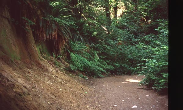
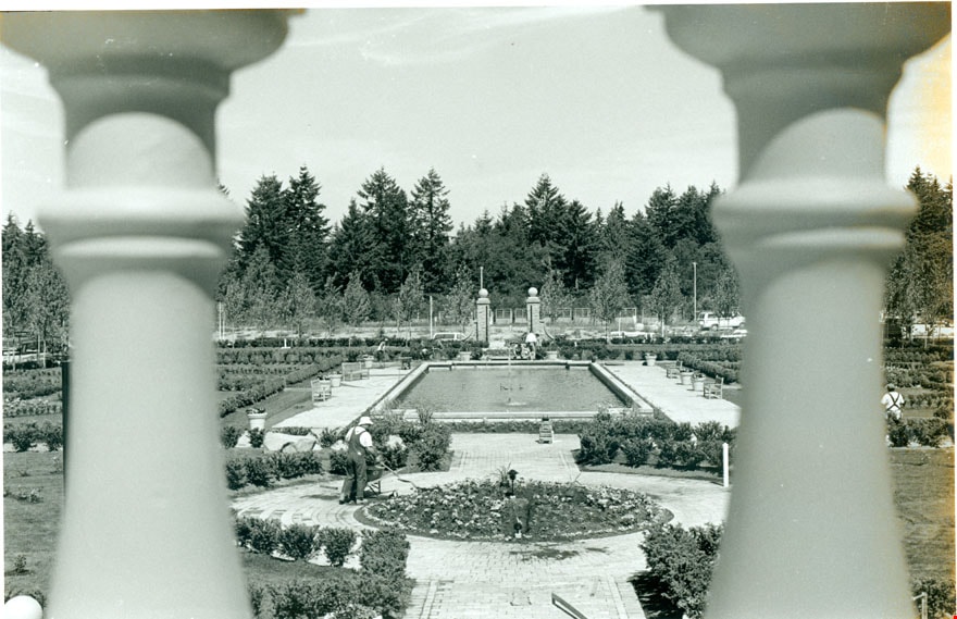
Cut of land on Burnaby Mountain
https://search.heritageburnaby.ca/link/archivedescription97810
- Repository
- City of Burnaby Archives
- Date
- 1996
- Collection/Fonds
- Burnaby Mountain Preservation Society fonds
- Description Level
- Item
- Physical Description
- 1 photograph : col. slide ; 35 mm
- Scope and Content
- Photograph of a cut of land.
- Repository
- City of Burnaby Archives
- Date
- 1996
- Collection/Fonds
- Burnaby Mountain Preservation Society fonds
- Physical Description
- 1 photograph : col. slide ; 35 mm
- Description Level
- Item
- Record No.
- 629-011
- Access Restriction
- No restrictions
- Reproduction Restriction
- Reproduce for fair dealing purposes only
- Accession Number
- 2006-13
- Scope and Content
- Photograph of a cut of land.
- Subjects
- Geographic Features - Trails
- Media Type
- Photograph
- Notes
- Stamp on slide reads: "July 08, 1996."
- Geographic Access
- Burnaby Mountain Conservation Area
- Planning Study Area
- Burnaby Mountain Area
Images
![Land surveyor on a road, [1999] thumbnail](/media/hpo/_Data/_Archives_Images/_Unrestricted/535/535-3313.jpg?width=280)
Land surveyor on a road
https://search.heritageburnaby.ca/link/archivedescription98246
- Repository
- City of Burnaby Archives
- Date
- [1999]
- Collection/Fonds
- Burnaby NewsLeader photograph collection
- Description Level
- Item
- Physical Description
- 1 photograph (tiff) : b&w
- Scope and Content
- Photograph of an unidentified land surveyor standing behind a land surveying total station at the curve of a road.
- Repository
- City of Burnaby Archives
- Date
- [1999]
- Collection/Fonds
- Burnaby NewsLeader photograph collection
- Physical Description
- 1 photograph (tiff) : b&w
- Description Level
- Item
- Record No.
- 535-3313
- Access Restriction
- No restrictions
- Reproduction Restriction
- No restrictions
- Accession Number
- 2018-12
- Scope and Content
- Photograph of an unidentified land surveyor standing behind a land surveying total station at the curve of a road.
- Media Type
- Photograph
- Notes
- Title based on contents of photograph
- Collected by editorial for use in a September 1999 issue of the Burnaby NewsLeader
Images
![Land surveyor on a road, [1999] thumbnail](/media/hpo/_Data/_Archives_Images/_Unrestricted/535/535-3313.jpg)
1160 Douglas Rd
https://search.heritageburnaby.ca/link/archivedescription94327
- Repository
- City of Burnaby Archives
- Date
- December 1994
- Collection/Fonds
- Grover, Elliott & Co. Ltd. fonds
- Description Level
- File
- Physical Description
- 22 photographs : col. negatives ; 35 mm
- Scope and Content
- Photographs of the exterior of a three-storey commerical building located at 1160 Douglas Road.
- Repository
- City of Burnaby Archives
- Date
- December 1994
- Collection/Fonds
- Grover, Elliott & Co. Ltd. fonds
- Physical Description
- 22 photographs : col. negatives ; 35 mm
- Description Level
- File
- Record No.
- 622-112
- Access Restriction
- No restrictions
- Reproduction Restriction
- No restrictions
- Accession Number
- 2017-39
- Scope and Content
- Photographs of the exterior of a three-storey commerical building located at 1160 Douglas Road.
- Media Type
- Photograph
- Photographer
- Young, Richard
- Notes
- Transcribed title
- Title transcribed from envelope photographs were originally housed in
- File no. 94-424-B
- Geographic Access
- Douglas Road
- Street Address
- 1160 Douglas Road
- Historic Neighbourhood
- Vancouver Heights (Historic Neighbourhood)
- Planning Study Area
- Willingdon Heights Area
4010 Regent St.
https://search.heritageburnaby.ca/link/archivedescription94318
- Repository
- City of Burnaby Archives
- Date
- September 1994
- Collection/Fonds
- Grover, Elliott & Co. Ltd. fonds
- Description Level
- File
- Physical Description
- 25 photographs : col. negatives ; 35 mm
- Scope and Content
- Photographs of an undeveloped property located at 4010 Regent Street. Property is covered with soil, brush, and some trees.
- Repository
- City of Burnaby Archives
- Date
- September 1994
- Collection/Fonds
- Grover, Elliott & Co. Ltd. fonds
- Physical Description
- 25 photographs : col. negatives ; 35 mm
- Description Level
- File
- Record No.
- 622-103
- Access Restriction
- No restrictions
- Reproduction Restriction
- No restrictions
- Accession Number
- 2017-39
- Scope and Content
- Photographs of an undeveloped property located at 4010 Regent Street. Property is covered with soil, brush, and some trees.
- Subjects
- Land Clearing
- Media Type
- Photograph
- Photographer
- Young, Richard
- Notes
- Transcribed title
- Title transcribed from envelope photographs were originally housed in
- File no. 94-342-B
- Geographic Access
- Regent Street
- Street Address
- 4010 Regent Street
- Historic Neighbourhood
- Broadview (Historic Neighbourhood)
- Planning Study Area
- West Central Valley Area
5200 Oakmount Cr.
https://search.heritageburnaby.ca/link/archivedescription94313
- Repository
- City of Burnaby Archives
- Date
- June 1994
- Collection/Fonds
- Grover, Elliott & Co. Ltd. fonds
- Description Level
- File
- Physical Description
- 23 photographs : col. negatives ; 35 mm
- Scope and Content
- Photographs of an undeveloped property located at 5200 Oakmount Crescent - an address that no longer exists.
- Repository
- City of Burnaby Archives
- Date
- June 1994
- Collection/Fonds
- Grover, Elliott & Co. Ltd. fonds
- Physical Description
- 23 photographs : col. negatives ; 35 mm
- Description Level
- File
- Record No.
- 622-098
- Access Restriction
- No restrictions
- Reproduction Restriction
- No restrictions
- Accession Number
- 2017-39
- Scope and Content
- Photographs of an undeveloped property located at 5200 Oakmount Crescent - an address that no longer exists.
- Subjects
- Land Clearing
- Media Type
- Photograph
- Notes
- Transcribed title
- Title transcribed from envelope photographs were originally housed in
- File no. 94-236-B
- Photographer identified as "J.C."
- Geographic Access
- Oakmount Crescent
- Historic Neighbourhood
- Central Park (Historic Neighbourhood)
- Planning Study Area
- Windsor Area
5548 Marshland Ave
https://search.heritageburnaby.ca/link/archivedescription94302
- Repository
- City of Burnaby Archives
- Date
- January 1994
- Collection/Fonds
- Grover, Elliott & Co. Ltd. fonds
- Description Level
- File
- Physical Description
- 25 photographs : col. negatives ; 35 mm
- Scope and Content
- Photographs of an undeveloped property located at 5548 Marshland Avenue - an address that no longer exists.
- Repository
- City of Burnaby Archives
- Date
- January 1994
- Collection/Fonds
- Grover, Elliott & Co. Ltd. fonds
- Physical Description
- 25 photographs : col. negatives ; 35 mm
- Description Level
- File
- Record No.
- 622-087
- Access Restriction
- No restrictions
- Reproduction Restriction
- No restrictions
- Accession Number
- 2017-39
- Scope and Content
- Photographs of an undeveloped property located at 5548 Marshland Avenue - an address that no longer exists.
- Subjects
- Land Clearing
- Media Type
- Photograph
- Notes
- Transcribed title
- Title transcribed from envelope photographs were originally housed in
- File no. 94-023-B
- Photographer identified as "K.D."
- Geographic Access
- Marshland Avenue
- Historic Neighbourhood
- Fraser Arm (Historic Neighbourhood)
- Planning Study Area
- Big Bend Area
7026 Kingsway
https://search.heritageburnaby.ca/link/archivedescription94304
- Repository
- City of Burnaby Archives
- Date
- January 1994
- Collection/Fonds
- Grover, Elliott & Co. Ltd. fonds
- Description Level
- File
- Physical Description
- 19 photographs : col. negatives ; 35 mm
- Scope and Content
- Photographs of commercial and undeveloped properties located in the 7100 block of Kingsway, including Middlegate Honda, with mid-rise towers visible in the background.
- Repository
- City of Burnaby Archives
- Date
- January 1994
- Collection/Fonds
- Grover, Elliott & Co. Ltd. fonds
- Physical Description
- 19 photographs : col. negatives ; 35 mm
- Description Level
- File
- Record No.
- 622-089
- Access Restriction
- No restrictions
- Reproduction Restriction
- No restrictions
- Accession Number
- 2017-39
- Scope and Content
- Photographs of commercial and undeveloped properties located in the 7100 block of Kingsway, including Middlegate Honda, with mid-rise towers visible in the background.
- Media Type
- Photograph
- Notes
- Transcribed title
- Title transcribed from envelope photographs were originally housed in
- File no. 94-028-B
- Photographer identified as "L.D."
- Geographic Access
- Kingsway
- Historic Neighbourhood
- Edmonds (Historic Neighbourhood)
- Planning Study Area
- Stride Avenue Area
8980 Fraserwood Crt
https://search.heritageburnaby.ca/link/archivedescription94326
- Repository
- City of Burnaby Archives
- Date
- December 1994
- Collection/Fonds
- Grover, Elliott & Co. Ltd. fonds
- Description Level
- File
- Physical Description
- 24 photographs : col. negatives ; 35 mm
- Scope and Content
- Photographs of an undeveloped property located at 8980 Fraserwood Court. A Sutton Group real estate sign on the property advertises the site as the Fraserwood Corporate Centre with strata warehouse and office flex space. File also contains photographs of the commerical building adjacent to the si…
- Repository
- City of Burnaby Archives
- Date
- December 1994
- Collection/Fonds
- Grover, Elliott & Co. Ltd. fonds
- Physical Description
- 24 photographs : col. negatives ; 35 mm
- Description Level
- File
- Record No.
- 622-111
- Access Restriction
- No restrictions
- Reproduction Restriction
- No restrictions
- Accession Number
- 2017-39
- Scope and Content
- Photographs of an undeveloped property located at 8980 Fraserwood Court. A Sutton Group real estate sign on the property advertises the site as the Fraserwood Corporate Centre with strata warehouse and office flex space. File also contains photographs of the commerical building adjacent to the site.
- Media Type
- Photograph
- Notes
- Transcribed title
- Title transcribed from envelope photographs were originally housed in
- File no. 94-422-B
- Photographer identified as "L.D."
- Geographic Access
- Fraserwood Court
- Street Address
- 8980 Fraserwood Court
- Historic Neighbourhood
- Fraser Arm (Historic Neighbourhood)
- Planning Study Area
- Big Bend Area
Burnaby
https://search.heritageburnaby.ca/link/archivedescription93751
- Repository
- City of Burnaby Archives
- Date
- 1991
- Collection/Fonds
- Grover, Elliott & Co. Ltd. fonds
- Description Level
- File
- Physical Description
- 43 photographs : col. negatives ; 35 mm
- Scope and Content
- Photographs of the exterior of a single-storey industrial building and surrounding undeveloped property. A sign on the building reads "Bauer". The location of the building has not been identified.
- Repository
- City of Burnaby Archives
- Date
- 1991
- Collection/Fonds
- Grover, Elliott & Co. Ltd. fonds
- Physical Description
- 43 photographs : col. negatives ; 35 mm
- Description Level
- File
- Record No.
- 622-036
- Access Restriction
- No restrictions
- Reproduction Restriction
- No restrictions
- Accession Number
- 2017-39
- Scope and Content
- Photographs of the exterior of a single-storey industrial building and surrounding undeveloped property. A sign on the building reads "Bauer". The location of the building has not been identified.
- Subjects
- Buildings - Industrial
- Land Clearing
- Media Type
- Photograph
- Notes
- Transcribed title
- Title transcribed from envelope photographs were originally housed in
- File no. 91-452-B

Residents involved in protesting tree removal
https://search.heritageburnaby.ca/link/archivedescription78595
- Repository
- City of Burnaby Archives
- Date
- October 8, 1995
- Collection/Fonds
- Burnaby NewsLeader photograph collection
- Description Level
- Item
- Physical Description
- 1 photograph : b&w ; 16.5 x 24.5 cm
- Scope and Content
- Photograph of residents of Burnaby protesting the clearing of land around the Hong Kong Bank, in Discovery Park industrial site near British Columbia Institute of Technology (BCIT).
- Repository
- City of Burnaby Archives
- Date
- October 8, 1995
- Collection/Fonds
- Burnaby NewsLeader photograph collection
- Physical Description
- 1 photograph : b&w ; 16.5 x 24.5 cm
- Description Level
- Item
- Record No.
- 535-0011
- Access Restriction
- No restrictions
- Reproduction Restriction
- No reproduction permitted
- Accession Number
- 2012-11
- Scope and Content
- Photograph of residents of Burnaby protesting the clearing of land around the Hong Kong Bank, in Discovery Park industrial site near British Columbia Institute of Technology (BCIT).
- Names
- Chami, Parvin
- Media Type
- Photograph
- Photographer
- Ponne, Simone
- Notes
- Title based on contents of photograph
- Note in black ink on recto of photograph reads: "2764A Bby Ponne / Bby p. 1 81%"
- Trim marks and/or reproduction instructions on recto (scan is cropped)
- Geographic Access
- Willingdon Avenue
- Planning Study Area
- Douglas-Gilpin Area
Images

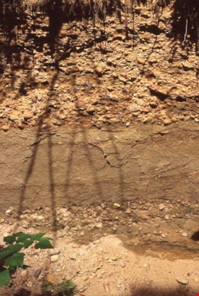
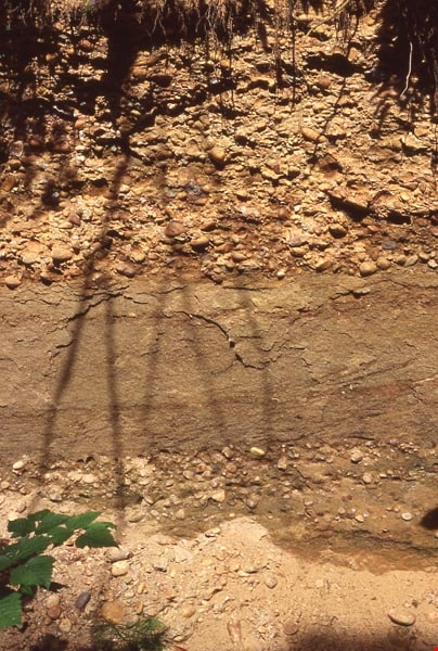
Sediment layers on Burnaby Mountain
https://search.heritageburnaby.ca/link/archivedescription97811
- Repository
- City of Burnaby Archives
- Date
- 1996
- Collection/Fonds
- Burnaby Mountain Preservation Society fonds
- Description Level
- Item
- Physical Description
- 1 photograph : col. slide ; 35 mm
- Scope and Content
- Photograph of sediment layers.
- Repository
- City of Burnaby Archives
- Date
- 1996
- Collection/Fonds
- Burnaby Mountain Preservation Society fonds
- Physical Description
- 1 photograph : col. slide ; 35 mm
- Description Level
- Item
- Record No.
- 629-012
- Access Restriction
- No restrictions
- Reproduction Restriction
- Reproduce for fair dealing purposes only
- Accession Number
- 2006-13
- Scope and Content
- Photograph of sediment layers.
- Subjects
- Land
- Media Type
- Photograph
- Notes
- Stamp on slide reads: "July 08, 1996."
- Geographic Access
- Burnaby Mountain Conservation Area
- Planning Study Area
- Burnaby Mountain Area
Images
Baldwin family subseries
https://search.heritageburnaby.ca/link/archivedescription65666
- Repository
- City of Burnaby Archives
- Date
- 1964-2002
- Collection/Fonds
- Burnaby Historical Society fonds
- Description Level
- Subseries
- Physical Description
- Textual records and photographs
- Scope and Content
- Subseries consist of records pertaining to the Baldwin family home. Included in the fonds are newspaper clippings, magazine articles, and photographs of the house taken by Basil King.
- Repository
- City of Burnaby Archives
- Date
- 1964-2002
- Collection/Fonds
- Burnaby Historical Society fonds
- Subseries
- Baldwin family subseries
- Physical Description
- Textual records and photographs
- Description Level
- Subseries
- Accession Number
- BHS1998-03
- Scope and Content
- Subseries consist of records pertaining to the Baldwin family home. Included in the fonds are newspaper clippings, magazine articles, and photographs of the house taken by Basil King.
- History
- In 1959 Dr. William "Bill" Baldwin (d. 1987) and his wife Ruth (d. 2009) bought a cottage and approximately two and a half acres of land on the shores of Deer Lake for $16,000. The cottage and land had been owned by one of Dr. Baldwin’s colleagues at Burnaby Hospital. The couple lived in the cottage with their two young children John (b.1958) and Susan (b.1959) for a few years before deciding to renovate and expand their home. William was close friends with Arthur Erickson, the two having gone to Prince of Wales High School and McGill University together. Ruth decided that they needed a lakeshore home rather than a renovation on their cottage and Arthur Erickson would be the man to design it. Local builder Torstein Kravik completed the house in 1965. The home is considered an early example of Erickson’s design aesthetic, demonstrating his vision of "site, light and cadence." It is thought to be the best example of West Coast contemporary architecture in Burnaby. In 2001, at the age of seventy-eight, Ruth approached the City of Burnaby about buying the property,on the condition that the house be protected and that Ruth could continue to rent the home. The City purchased it and gave it Heritage designation. As of 2010, the Baldwin home and garden is on lease to The Land Conservancy of BC (TLC) to serve as a “guest house.” It is available for lease to local residents and visitors for overnight stays.
- Media Type
- Photograph
- Textual Record
- Creator
- Baldwin, Ruth
- Notes
- Title based on contents of subseries
- Photo catalogue 357, MSS145
Grover, Elliott & Co. Ltd. fonds
https://search.heritageburnaby.ca/link/archivedescription93711
- Repository
- City of Burnaby Archives
- Date
- 1987-1998
- Collection/Fonds
- Grover, Elliott & Co. Ltd. fonds
- Description Level
- Fonds
- Physical Description
- 3847 photographs (92 col. prints, 10 cm x 15 cm ; 3754 col. negatives, 35 mm) + 4 computer disks (14 x 14 cm).
- Scope and Content
- The fonds consists of street-level photographs of commercial, industrial, residential, and undeveloped properties in Burnaby, B.C. These photographs originally formed part of the Grover, Elliott & Co. Ltd's real estate appraisal records.
- Repository
- City of Burnaby Archives
- Date
- 1987-1998
- Collection/Fonds
- Grover, Elliott & Co. Ltd. fonds
- Physical Description
- 3847 photographs (92 col. prints, 10 cm x 15 cm ; 3754 col. negatives, 35 mm) + 4 computer disks (14 x 14 cm).
- Description Level
- Fonds
- Access Restriction
- Open access
- Accession Number
- 2017-39
- Scope and Content
- The fonds consists of street-level photographs of commercial, industrial, residential, and undeveloped properties in Burnaby, B.C. These photographs originally formed part of the Grover, Elliott & Co. Ltd's real estate appraisal records.
- History
- Grover, Elliott, & Co. Ltd (Grover Elliot) is a real estate appraisal, valuation, and consulting firm that opened on January 2, 1974. It was founded by three real estate appraisers who took over an existing appraisal office. The firm provides real estate appraisals for all property types throughout British Columbia, including land, residential, industrial, and commercial properties. Grover Elliot was first located at 5685 Cambie Street in Vancouver, B.C. In June 1985, the firm moved its offices to the Burrard Building in downtown Vancouver on West Georgia St. in order to provide a base closer to the Land Title Office where employees regularly conducted research. In May 2016, it moved to 609 West Hastings Street in Vancouver, B.C. In February 2018, following the retirement of owner and President Larry Dybvig, the firm was purchased by three Grover Elliott appraisers: Angus Heaps, Brent McLaren, and Michael Oord. Dybvig served as President of the firm from 2001 to 2018. The company provides appraisals for all types of real estate including land, multifamily residential, industrial properties, and commercial properties.
- Media Type
- Photograph
- Creator
- Grover, Elliott & Co. Ltd.
- Notes
- Photo catalogue 622
Small family fonds
https://search.heritageburnaby.ca/link/archivedescription91819
- Repository
- City of Burnaby Archives
- Date
- 1922-2016
- Collection/Fonds
- Small family fonds
- Description Level
- Fonds
- Physical Description
- 75 photographs : b&w & col. + 1 plan
- Scope and Content
- Fonds consists of photographs documenting the transformation of the Burnaby Lake area of Burnaby, B.C. from semi-rural in the 1920s to urbanized in 2016. Photographs depict the land and houses located on the corner of Douglas Road and Dominion Street as the property was rezoned and its density quad…
- Repository
- City of Burnaby Archives
- Date
- 1922-2016
- Collection/Fonds
- Small family fonds
- Physical Description
- 75 photographs : b&w & col. + 1 plan
- Description Level
- Fonds
- Access Restriction
- Open access
- Reproduction Restriction
- May be restricted by third party rights
- Accession Number
- 2017-01
- Scope and Content
- Fonds consists of photographs documenting the transformation of the Burnaby Lake area of Burnaby, B.C. from semi-rural in the 1920s to urbanized in 2016. Photographs depict the land and houses located on the corner of Douglas Road and Dominion Street as the property was rezoned and its density quadrupled. Fonds also includes photographs of the Small family house being moved to 5496 Dominion Street and the original landscape plan for 5118 Douglas Road.
- History
- In 1915, John W. Roberts and his wife Mary Allen Roberts moved from the United States to Canada along with their daughter, Lauretta. On first moving to Canada, the family lived in a rented house in Vancouver and John worked as a movie projectionist in the city. The couple had three more children, all sons: John A., Edward, and Roland. Circa 1921, John purchased a large parcel of land at the corner of Douglas Road and Dominion Street in Burnaby. This parcel encompassed the equivalent of at least six 66-foot lots along the south side of Dominion Street and the same along the north side of Norfolk Street. On their property, a barn and small living quarters were built. The family moved in, raising goats and growing potatoes to supplement their income. They also planted cherry, apple, and pear trees; hazelnut and walnut trees; raspberries; and a large vegetable garden, the fruits of which Mary preserved for year-round use. At this time, agricultural activities were common for families in the area: the Roberts' neighbours kept chickens for personal use and for selling eggs; grew mushrooms for commercial sale; and sold manure from an old buckboard drawn by Clydesdale horses. John built a new house in the middle of the Roberts’ lots on the southwest corner of Douglas Road and Dominion Street. The house faced Douglas Road and overlooked a large, well-landscaped front yard to the east and a full-sized, clay tennis court to the north. The family moved into this new house in 1925. When the Roberts ceased raising goats, the barn and original living quarters were reduced to a double-car garage with storage space plus a sawdust-insulated “root cellar”. John also built a house on the northwest corner of the lot at Douglas Road and Dominion Street (3093 Douglas Road), which was purchased by the Hardy family. In 1957, part of this property (3071 Douglas Road) was sold to the Brocklebanks who built a house and lived there. In addition, John built a house at the northwest corner of Douglas Road and Norfolk Street (5106 Douglas Road). The original purchaser of this house is unknown, but in 1949, it was bought by the Meyers family. In 1952 or 1953, the Meyers sold part of this property and the Manahans built a house on it, facing Douglas Road. Several other lots that John owned were also sold off over the years. By the 1950s, John owned only five 66-foot lots from Douglas Road west, along the south side Dominion Street. In 1954, John sold the lot furthest from Douglas Road (5486 Dominion Street) to a builder who built a “ranch-style” house and put it up for sale. John retired from his career as a movie projectionist in the 1950s. He, Mary, and Lauretta retained their US citizenship all their lives, although they never returned to the USA except for brief visits. John A., Edward, and Roland who, as children of US citizens, also had US citizenship, eventually moved to the US, where they remained for the rest of their lives. In 1945, Lauretta married Frederick Small. The couple lived in a rented house in Vancouver for a few years before moving in with John and Mary in Burnaby. The couple had four children: Elizabeth, Kathryn, Charles, and Martin. In 1955, Frederick purchased the rancher at 5486 Dominion Street and the family moved in. The Small children grew up enjoying the freedom of having their grandparent’s large property in addition to their parent’s yard to play in. The back lane that ran between Dominion Street and Norfolk Street was filled with trees and bushes, creating a narrow bit of “forest” to explore. In 1957, John died. Mary died in 1969, as did Frederick. Lauretta was executor for her mother’s and husband’s estates. After much consideration, she decided to sell the house at 5486 Dominion Street and move back into her childhood home. By doing so, she was able to settle her mother’s estate to the satisfaction of her brothers. Elizabeth married and moved away. Over the next few years, the “Roberts” house was home to Lauretta, Kathryn, Charles, and Martin, with the three grown children moving in and out several times during the 1970s. In 1981, Lauretta died. Her children discussed at length how to divide up the property, which consisted of four 66-foot lots, according to her will. None of her children wanted to see the old family house destroyed but the house straddled two lots. They finally decided that if one of them wanted to pay to move the house to sit on one of the lots, the “value” of the house would not enter into the settlement of the estate. Kathryn chose to do this. In 1982, the old house was moved to 5496 Dominion Street and Kathryn continued to live in it. Martin died in 1982. Elizabeth and Charles each inherited one lot and the last lot, which would have gone to Martin, was sold, the funds divided equally between Elizabeth, Kathryn, and Charles. The three lots between 5496 Dominion Street and Douglas Road were subdivided into 33-foot lots and six new houses were built. In 1993, the Meyers property and the Manahan property were subdivided into 33-foot lots facing Norfolk Street and the old houses were torn down and four new houses were built.
- Media Type
- Photograph
- Technical Drawing
- Creator
- Small family
Advisory Planning Commission subseries
https://search.heritageburnaby.ca/link/archivedescription96030
- Repository
- City of Burnaby Archives
- Date
- [1960]-2012
- Collection/Fonds
- City Council and Office of the City Clerk fonds
- Description Level
- Subseries
- Physical Description
- 40 folders of textual records + 1 photograph
- Scope and Content
- Subseries consists of commission records for the Advisory Planning Commission including agendas, minutes, reports, and correspondence and a Commission portrait.
- Repository
- City of Burnaby Archives
- Date
- [1960]-2012
- Collection/Fonds
- City Council and Office of the City Clerk fonds
- Series
- Council Committee series
- Subseries
- Advisory Planning Commission subseries
- Physical Description
- 40 folders of textual records + 1 photograph
- Description Level
- Subseries
- Scope and Content
- Subseries consists of commission records for the Advisory Planning Commission including agendas, minutes, reports, and correspondence and a Commission portrait.
- History
- The Advisory Planning Commission was established in July of 1963. The Advisory Planning Commission was the successor to the Town Planning Commission. The Commission was responsible for advising Council on land use matters and reviewing all zoning bylaw amendments before being forwarded to public hearing. The Commission was disbanded on February 20, 2017.
- Media Type
- Textual Record
- Photograph
- Graphic Material
Appraisal documents
https://search.heritageburnaby.ca/link/archivedescription88429
- Repository
- City of Burnaby Archives
- Date
- 1993
- Collection/Fonds
- Krewenchuk family fonds
- Description Level
- File
- Physical Description
- 5 p. of textual records + 2 photographs : col. (Polaroid) ; 7 x 9 cm
- Scope and Content
- File consists of land appraisal documents for 7460 Salisbury Avenue, Lot 167, D.L.95, Group 1, Plan 30087 and 30088. The appraisal document includes documents regarding the estimated value of the property, a lot plan and two colour photographs of the house and property.
- Repository
- City of Burnaby Archives
- Date
- 1993
- Collection/Fonds
- Krewenchuk family fonds
- Physical Description
- 5 p. of textual records + 2 photographs : col. (Polaroid) ; 7 x 9 cm
- Description Level
- File
- Record No.
- MSS192-002
- Access Restriction
- In Archives only
- Reproduction Restriction
- No reproduction permitted
- Accession Number
- 2015-05
- Scope and Content
- File consists of land appraisal documents for 7460 Salisbury Avenue, Lot 167, D.L.95, Group 1, Plan 30087 and 30088. The appraisal document includes documents regarding the estimated value of the property, a lot plan and two colour photographs of the house and property.
- Media Type
- Textual Record
- Photograph
- Notes
- Title based on contents of file
Belgravia at City in the Park
https://search.heritageburnaby.ca/link/archivedescription79322
- Repository
- City of Burnaby Archives
- Date
- July 14, 1996
- Collection/Fonds
- Burnaby NewsLeader photograph collection
- Description Level
- Item
- Physical Description
- 1 photograph : b&w ; 15 x 23 cm
- Scope and Content
- Photograph of Belgravia at City in the Park housing development project on former south Burnaby industrial land. Developers have re-created an old world setting, complete with stone walls and a private formal garden.
- Repository
- City of Burnaby Archives
- Date
- July 14, 1996
- Collection/Fonds
- Burnaby NewsLeader photograph collection
- Physical Description
- 1 photograph : b&w ; 15 x 23 cm
- Description Level
- Item
- Record No.
- 535-0350
- Access Restriction
- No restrictions
- Reproduction Restriction
- No reproduction permitted
- Accession Number
- 2012-11
- Scope and Content
- Photograph of Belgravia at City in the Park housing development project on former south Burnaby industrial land. Developers have re-created an old world setting, complete with stone walls and a private formal garden.
- Subjects
- Geographic Features - Parks
- Media Type
- Photograph
- Photographer
- Langdeau, Brian
- Notes
- Title based on contents of photograph
- Note in black ink on recto of photograph reads: "Bby pg 1. / B 1812 Brian Bby / 82%"
- Trim marks and/or reproduction instructions on recto (scan is cropped)
Images

Burnaby Lake Pilot Dredging Project
https://search.heritageburnaby.ca/link/archivedescription91710
- Repository
- City of Burnaby Archives
- Date
- August 1999 - September 1999
- Collection/Fonds
- Doreen Lawson fonds
- Description Level
- File
- Physical Description
- 19 photographs : col. slides ; 35 mm
- Scope and Content
- File consists of photographs documenting the Burnaby Lake Pilot Dredging Project undertaken by the City of Burnaby between August 20 and September 16, 1999. Photographs depict silt-laded water in Still Creek prior to the dredging, mechanical dredging equipment on land and in use on the lake, and t…
- Repository
- City of Burnaby Archives
- Date
- August 1999 - September 1999
- Collection/Fonds
- Doreen Lawson fonds
- Physical Description
- 19 photographs : col. slides ; 35 mm
- Description Level
- File
- Record No.
- 618-029
- Access Restriction
- No restrictions
- Reproduction Restriction
- No restrictions
- Accession Number
- 2015-15
- Scope and Content
- File consists of photographs documenting the Burnaby Lake Pilot Dredging Project undertaken by the City of Burnaby between August 20 and September 16, 1999. Photographs depict silt-laded water in Still Creek prior to the dredging, mechanical dredging equipment on land and in use on the lake, and the adjacent water treatment facility. Also contained in the file are photographs of Deputy Director of Engineering, Lambert Chu, speaking at the dredging site and vials containing two water samples: one clear and one opaque with brown sediment.
- Media Type
- Photograph
- Photographer
- Lawson, Doreen A.
- Notes
- Title based on contents of photographs
- Geographic Access
- Burnaby Lake
- Still Creek
- Historic Neighbourhood
- Burnaby Lake (Historic Neighbourhood)
- Planning Study Area
- Burnaby Lake Area
Images

Doreen Lawson fonds
https://search.heritageburnaby.ca/link/archivedescription58356
- Repository
- City of Burnaby Archives
- Date
- 1950-2002
- Collection/Fonds
- Doreen Lawson fonds
- Description Level
- Fonds
- Physical Description
- 18 cm of textual records + approx. 1000 photographs
- Scope and Content
- Fonds consists of records created and received by Doreen Lawson during her career as Parks Commissioner (1965-1971), Burnaby City Council member (1972-1985, 1990-1999) and environmental advocate following her retirement from Council in 1999. Records include election campaign materials, congratulat…
- Repository
- City of Burnaby Archives
- Date
- 1950-2002
- Collection/Fonds
- Doreen Lawson fonds
- Physical Description
- 18 cm of textual records + approx. 1000 photographs
- Description Level
- Fonds
- Accession Number
- 2003-30
- 2015-15
- Scope and Content
- Fonds consists of records created and received by Doreen Lawson during her career as Parks Commissioner (1965-1971), Burnaby City Council member (1972-1985, 1990-1999) and environmental advocate following her retirement from Council in 1999. Records include election campaign materials, congratulatory letters and correspondence, community speeches and slideshow presentations regarding the conservation of Burnaby Lake, the administrative papers of the Burnaby Centennial Rhododendron and Spring Flower Show Society, and photographs of Burnaby waterways and wildlife.
- History
- Doreen Anne Fowler Lawson was born July 8, 1928, to Eva Barnhill and Leonard Fowler. Her parents met in Alberta but decided to move to Vancouver where they got married and Doreen was born. The family moved to the north side of Claude Avenue in Burnaby when Doreen was a few months old. In 1931, they moved to a house with an acre of land directly across the street from their first house.
- When Doreen was six, her family moved to Collingwood, Vancouver, near where her father grew up. This is where her brother Ron was born. The family moved again to County Line in Langley Prairie in 1944, which is where Doreen met Edward Lawson, her future husband. Soon after, they moved to a seven-acre plot in Burquitlam. Ed and Doreen Lawson’s eldest daughter, Linda, was born in 1954. Their second daughter, Wendy, was born in 1959 and their youngest, Lisa, was born in 1961. They lived in the Brentwood area, where all three daughters attended Brentwood Elementary School. Linda went on to Alpha Secondary School.
- In 1945, Doreen began her first of several office jobs, and in the early 1950s she became the first woman to be elected into a vice-president position within the BC Trade Union Congress (now the BC Federation of Labour).
- Doreen Lawson had a long and prolific political career, starting as Parks Commissioner in 1965, and serving as its chair from 1969 to 1971. She was instrumental in the selection and promotion of the rhododendron as the official flower of Burnaby in 1966. In 1971, she was elected to Burnaby City Council and, in 1972, Doreen proposed that Council take action to declare Burnaby Lake a wildlife sanctuary. After a 10-year campaign, she was able to convince Council to declare the park “a nature conservation area.” She put forward a policy of preservation for creeks and streams, as well as a proposal to preserve trees in subdivisions, both of which were adopted by Council. Doreen continued to serve on Council until 1985, during which time she initiated and chaired the Burnaby Information Committee, which designed the present Burnaby logo (and official flower pins) and established the Information Burnaby Newsletter. In 1979 Doreen Lawson won Vancouver Natural History Society’s Frank Sanford Award.
- In 1984, Doreen was elected the first woman president of the Federation of Canadian Municipalities. Doreen ran as a BC Liberal Party candidate in the new Federal Riding of Burnaby in 1979, and from 1985 to 1987, she served as the Executive Director of the British Columbia Liberal Party. As the B.C. Liberal Party Executive Director, her major responsibility was to work with both the Federal and Provincial Associations in implementing riding organizations and fundraising programs in preparation for election time. In the 1980s, Doreen was an active guest lecturer at Burnaby Elementary and High Schools as well as at the University of British Columbia and Simon Fraser University. Doreen was active in a variety of community clubs and organizations including: the Burnaby Library Board; Greater Vancouver Spinners and Weavers Guild; and Vancouver Natural History Society. She was an executive member of the Burnaby-New Westminster Canada Summer Games; the Burnaby Division of the United Way; Information Burnaby Committee; and the Brentwood Parent Teachers Association; as well as serving as the President of the Burnaby Voters Association from 1988-1990.
- In 1990, Doreen was elected back to Burnaby Council and put forward the rejuvenation of Burnaby Lake which she saw completed before her final year on Council in 1999. Doreen continued to be a strong environmental advocate for the protection and rejuvenation of Burnaby Lake after she retired from council.
- Doreen Lawson died October 11, 2003.
- Media Type
- Textual Record
- Photograph
- Creator
- Lawson, Doreen A.
- Notes
- Title based on contents of fonds
- MSS071, photo catalogue 605, photo catalogue 618
Graham Ford
https://search.heritageburnaby.ca/link/archivedescription79866
- Repository
- City of Burnaby Archives
- Date
- January 5, 1997
- Collection/Fonds
- Burnaby NewsLeader photograph collection
- Description Level
- Item
- Physical Description
- 1 photograph : b&w ; 22.5 x 17 cm
- Scope and Content
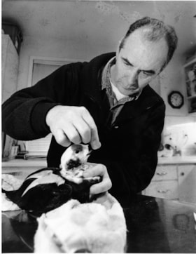
- Photograph of Graham Ford, director of Wildlife Rescue Association of British Columbia, tending to a Old Squaw after it was hurt trying to land on ice.
- Repository
- City of Burnaby Archives
- Date
- January 5, 1997
- Collection/Fonds
- Burnaby NewsLeader photograph collection
- Physical Description
- 1 photograph : b&w ; 22.5 x 17 cm
- Description Level
- Item
- Record No.
- 535-0552
- Access Restriction
- No restrictions
- Reproduction Restriction
- No reproduction permitted
- Accession Number
- 2012-11
- Scope and Content
- Photograph of Graham Ford, director of Wildlife Rescue Association of British Columbia, tending to a Old Squaw after it was hurt trying to land on ice.
- Subjects
- Animals - Poultry
- Media Type
- Photograph
- Photographer
- Bartel, Mario
- Notes
- Title based on contents of photograph
- Note in black and blue ink on recto of photograph reads: "50% page 4 Bby / 104 Bby Mario"
- Trim marks and/or reproduction instructions on recto (scan is cropped)
Images
