Narrow Results By
Decade
- 2020s 2
- 2010s 46
- 2000s 89
- 1990s 233
- 1980s
- 1970s
- 1960s 546
- 1950s 801
- 1940s 937
- 1930s 952
- 1920s 1152
- 1910s 813
- 1900s 231
- 1890s 74
- 1880s 11
- 1870s 8
- 1860s 10
- 1850s 5
- 1840s 3
- 1830s 2
- 1820s 2
- 1810s 3
- 1800s 3
- 1790s 2
- 1780s 2
- 1770s 2
- 1760s 2
- 1750s 2
- 1740s 2
- 1730s 2
- 1720s 2
- 1710s 2
- 1700s 2
- 1690s 2
- 1680s 2
- 1670s 1
- 1660s 1
- 1650s 1
- 1640s 1
- 1630s 1
- 1620s 1
- 1610s 1
- 1600s 1
- 1590s 1
- 1580s 1
- 1570s 1
- 1560s 1
- 1550s 1
- 1540s 1
- 1530s 1
- 1520s 1
- 1510s 1
- 1500s 1
- 1490s 1
- 1480s 1
![3700 Block Hastings Street, [196-] thumbnail](/media/hpo/_Data/_Archives_Images/_Unrestricted/316/366-002.jpg?width=280)
3700 Block Hastings Street
https://search.heritageburnaby.ca/link/archivedescription37373
- Repository
- City of Burnaby Archives
- Date
- [196-]
- Collection/Fonds
- Burnaby Historical Society fonds
- Description Level
- Item
- Physical Description
- 1 photograph : b&w negative
- Scope and Content
- Photograph shows a view looking west along the south side of the 3700 block of Hastings Street.
- Repository
- City of Burnaby Archives
- Date
- [196-]
- Collection/Fonds
- Burnaby Historical Society fonds
- Subseries
- Municipal record subseries
- Physical Description
- 1 photograph : b&w negative
- Description Level
- Item
- Record No.
- 366-002
- Access Restriction
- No restrictions
- Reproduction Restriction
- Reproduce for fair dealing purposes only
- Accession Number
- BHS1998-12
- Scope and Content
- Photograph shows a view looking west along the south side of the 3700 block of Hastings Street.
- Subjects
- Buildings
- Media Type
- Photograph
- Notes
- Title based on contents of photograph.
- Geographic Access
- Hastings Street
- Street Address
- 3700 Hastings Street
- Historic Neighbourhood
- Vancouver Heights (Historic Neighbourhood)
- Planning Study Area
- Willingdon Heights Area
Images
![3700 Block Hastings Street, [196-] thumbnail](/media/hpo/_Data/_Archives_Images/_Unrestricted/316/366-002.jpg)
![7342 Curtis Street, [1981] thumbnail](/media/hpo/_Data/_Archives_Images/_Unrestricted/371/382-002.jpg?width=280)
7342 Curtis Street
https://search.heritageburnaby.ca/link/archivedescription38276
- Repository
- City of Burnaby Archives
- Date
- [1981]
- Collection/Fonds
- Burnaby Historical Society fonds
- Description Level
- Item
- Physical Description
- 1 photograph : b&w ; 9 x 12.5 cm
- Scope and Content
- Photograph of the house located at 7342 Curtis Street.
- Repository
- City of Burnaby Archives
- Date
- [1981]
- Collection/Fonds
- Burnaby Historical Society fonds
- Subseries
- Photographs subseries
- Physical Description
- 1 photograph : b&w ; 9 x 12.5 cm
- Description Level
- Item
- Record No.
- 382-002
- Access Restriction
- No restrictions
- Reproduction Restriction
- Reproduce for fair dealing purposes only
- Accession Number
- BHS1999-12
- Scope and Content
- Photograph of the house located at 7342 Curtis Street.
- Subjects
- Buildings - Residential - Houses
- Media Type
- Photograph
- Notes
- Title based on contents of photograph
- Geographic Access
- Curtis Street
- Street Address
- 7342 Curtis Street
- Historic Neighbourhood
- Lochdale (Historic Neighbourhood)
- Planning Study Area
- Lochdale Area
Images
![7342 Curtis Street, [1981] thumbnail](/media/hpo/_Data/_Archives_Images/_Unrestricted/371/382-002.jpg)
A Development Programme for Burnaby Lake
https://search.heritageburnaby.ca/link/archivedescription62806
- Repository
- City of Burnaby Archives
- Date
- December 1975
- Collection/Fonds
- Burnaby Historical Society fonds
- Description Level
- Item
- Physical Description
- 1 booklet
- Scope and Content
- Item is a booklet entitled, "A Development Programme for Burnaby Lake Regional Park" produced by the Burnaby Planning Department in December of 1975.
- Repository
- City of Burnaby Archives
- Date
- December 1975
- Collection/Fonds
- Burnaby Historical Society fonds
- Subseries
- Municipal record subseries
- Physical Description
- 1 booklet
- Description Level
- Item
- Record No.
- MSS096-002
- Access Restriction
- Open access
- Accession Number
- BHS2001-09
- Scope and Content
- Item is a booklet entitled, "A Development Programme for Burnaby Lake Regional Park" produced by the Burnaby Planning Department in December of 1975.
- Media Type
- Textual Record
- Edition
- Second printing
- Notes
- Continuation of title: "...Regional Park"
Alistair Ross papers
https://search.heritageburnaby.ca/link/archivedescription65732
- Repository
- City of Burnaby Archives
- Date
- [1922]-[1998]
- Collection/Fonds
- Burnaby Historical Society fonds
- Description Level
- Item
- Physical Description
- 1 file of textual records (photocopies)
- Scope and Content
- Item is a four page, typewritten personal memory of growing up in Burnaby (photocopied), specifically of the Burnaby Lake Interurban, written by Alistair Ross.
- Repository
- City of Burnaby Archives
- Date
- [1922]-[1998]
- Collection/Fonds
- Burnaby Historical Society fonds
- Subseries
- Ross family subseries
- Physical Description
- 1 file of textual records (photocopies)
- Description Level
- Item
- Record No.
- MSS146-002
- Access Restriction
- Open access
- Accession Number
- BHS1999-14
- Scope and Content
- Item is a four page, typewritten personal memory of growing up in Burnaby (photocopied), specifically of the Burnaby Lake Interurban, written by Alistair Ross.
- Media Type
- Textual Record
- Notes
- Title based on contents of file
![Burnaby Art Gallery, [1980] thumbnail](/media/hpo/_Data/_Archives_Images/_Unrestricted/316/349-002.jpg?width=280)
Burnaby Art Gallery
https://search.heritageburnaby.ca/link/archivedescription37306
- Repository
- City of Burnaby Archives
- Date
- [1980]
- Collection/Fonds
- Burnaby Historical Society fonds
- Description Level
- Item
- Physical Description
- 1 photograph : b&w ; 10 x 15 cm
- Scope and Content
- Photograph of the exterior of the Burnaby Art Gallery and parking lot. This building was formerly the H. Ceperley family's Fairacres estate, built in 1911.
- Repository
- City of Burnaby Archives
- Date
- [1980]
- Collection/Fonds
- Burnaby Historical Society fonds
- Subseries
- Jim Wolf subseries
- Physical Description
- 1 photograph : b&w ; 10 x 15 cm
- Description Level
- Item
- Record No.
- 349-002
- Access Restriction
- No restrictions
- Reproduction Restriction
- Reproduce for fair dealing purposes only
- Accession Number
- BHS1997-09
- Scope and Content
- Photograph of the exterior of the Burnaby Art Gallery and parking lot. This building was formerly the H. Ceperley family's Fairacres estate, built in 1911.
- Names
- Burnaby Art Gallery
- Media Type
- Photograph
- Photographer
- Houghtaling, Kim
- Notes
- Title based on contents of photograph
- Geographic Access
- Deer Lake Avenue
- Street Address
- 6344 Deer Lake Avenue
- Historic Neighbourhood
- Burnaby Lake (Historic Neighbourhood)
- Planning Study Area
- Douglas-Gilpin Area
Images
![Burnaby Art Gallery, [1980] thumbnail](/media/hpo/_Data/_Archives_Images/_Unrestricted/316/349-002.jpg)
![Burnaby Lake Pavilion, [1972] thumbnail](/media/hpo/_Data/_Archives_Images/_Unrestricted/371/389-002.jpg?width=280)
Burnaby Lake Pavilion
https://search.heritageburnaby.ca/link/archivedescription39789
- Repository
- City of Burnaby Archives
- Date
- [1972]
- Collection/Fonds
- Burnaby Historical Society fonds
- Description Level
- Item
- Physical Description
- 1 photograph : b&w ; 8.7 x 13.3 cm
- Scope and Content
- Photograph of the Burnaby Lake Rowing Pavilion. The pavilion and other facilities at Burnaby Lake were built in the early 1970s in preparation for the 1973 Canada Summer Games which were co-hosted in 1973 by Burnaby and New Westminster.
- Repository
- City of Burnaby Archives
- Date
- [1972]
- Collection/Fonds
- Burnaby Historical Society fonds
- Subseries
- Photographs subseries
- Physical Description
- 1 photograph : b&w ; 8.7 x 13.3 cm
- Description Level
- Item
- Record No.
- 389-002
- Access Restriction
- No restrictions
- Reproduction Restriction
- Reproduce for fair dealing purposes only
- Accession Number
- BHS2007-04
- Scope and Content
- Photograph of the Burnaby Lake Rowing Pavilion. The pavilion and other facilities at Burnaby Lake were built in the early 1970s in preparation for the 1973 Canada Summer Games which were co-hosted in 1973 by Burnaby and New Westminster.
- Media Type
- Photograph
- Notes
- Title based on contents of photograph.
- Geographic Access
- Burnaby Lake
- Roberts Street
- Street Address
- 6871 Roberts Street
- Historic Neighbourhood
- Burnaby Lake (Historic Neighbourhood)
- Planning Study Area
- Burnaby Lake Area
Images
![Burnaby Lake Pavilion, [1972] thumbnail](/media/hpo/_Data/_Archives_Images/_Unrestricted/371/389-002.jpg)

Burnaby Mountain Park
https://search.heritageburnaby.ca/link/archivedescription37403
- Repository
- City of Burnaby Archives
- Date
- 1970
- Collection/Fonds
- Burnaby Historical Society fonds
- Description Level
- Item
- Physical Description
- 1 photograph : col. postcard ; 9 x 14 cm
- Scope and Content
- Photograph of Burnaby Mountain Park looking west towards Vancouver. The caption on the back of the postcard reads: "This view was taken from Burnaby Mountain Park, which is adjacent to Simon Fraser University. Some of the most spectacular views can be seen from this high elevation."
- Repository
- City of Burnaby Archives
- Date
- 1970
- Collection/Fonds
- Burnaby Historical Society fonds
- Subseries
- Robert Prittie subseries
- Physical Description
- 1 photograph : col. postcard ; 9 x 14 cm
- Description Level
- Item
- Record No.
- 369-002
- Access Restriction
- No restrictions
- Reproduction Restriction
- Reproduce for fair dealing purposes only
- Accession Number
- BHS1999-01
- Scope and Content
- Photograph of Burnaby Mountain Park looking west towards Vancouver. The caption on the back of the postcard reads: "This view was taken from Burnaby Mountain Park, which is adjacent to Simon Fraser University. Some of the most spectacular views can be seen from this high elevation."
- Media Type
- Photograph
- Photographer
- Weinhaupl, George
- Notes
- Title based on contents of photograph
- Geographic Access
- Burnaby Mountain Conservation Area
- Centennial Way
- Street Address
- 100 Centennial Way
- Planning Study Area
- Burnaby Mountain Area
Images

Burnaby Procedure Bylaw 1971
https://search.heritageburnaby.ca/link/archivedescription58386
- Repository
- City of Burnaby Archives
- Date
- 1971
- Collection/Fonds
- Burnaby Historical Society fonds
- Description Level
- Item
- Physical Description
- 1 booklet
- Scope and Content
- Item is a booklet containing the "Burnaby Procedure Bylaw 1971 / Bylaw No. 6023 / A Bylaw to regulate the proceedings of the Municipal Council of The Corporation of the District of Burnaby (Consolidated for convenience with Bylaws Nos. 6535, 7466 and 8961)."
- Repository
- City of Burnaby Archives
- Date
- 1971
- Collection/Fonds
- Burnaby Historical Society fonds
- Subseries
- Municipal record subseries
- Physical Description
- 1 booklet
- Description Level
- Item
- Record No.
- MSS081-002
- Accession Number
- BHS1996-09
- Scope and Content
- Item is a booklet containing the "Burnaby Procedure Bylaw 1971 / Bylaw No. 6023 / A Bylaw to regulate the proceedings of the Municipal Council of The Corporation of the District of Burnaby (Consolidated for convenience with Bylaws Nos. 6535, 7466 and 8961)."
- Media Type
- Textual Record

Burnett home
https://search.heritageburnaby.ca/link/archivedescription37371
- Repository
- City of Burnaby Archives
- Date
- 1974
- Collection/Fonds
- Burnaby Historical Society fonds
- Description Level
- Item
- Physical Description
- 1 photograph : col. ; 9 x 12.8 cm
- Scope and Content
- Photograph of the home of Mr. Burnett (old street number 6561 Canada Way).
- Repository
- City of Burnaby Archives
- Date
- 1974
- Collection/Fonds
- Burnaby Historical Society fonds
- Subseries
- Photographs subseries
- Physical Description
- 1 photograph : col. ; 9 x 12.8 cm
- Description Level
- Item
- Record No.
- 365-002
- Access Restriction
- No restrictions
- Reproduction Restriction
- Reproduce for fair dealing purposes only
- Accession Number
- BHS2007-04
- Scope and Content
- Photograph of the home of Mr. Burnett (old street number 6561 Canada Way).
- Subjects
- Buildings - Residential - Houses
- Media Type
- Photograph
- Notes
- Title based on caption
- Geographic Access
- Canada Way
- Planning Study Area
- Lakeview-Mayfield Area
Images


Central Park Pharmacy
https://search.heritageburnaby.ca/link/archivedescription35025
- Repository
- City of Burnaby Archives
- Date
- July 1986
- Collection/Fonds
- Burnaby Historical Society fonds
- Description Level
- Item
- Physical Description
- 1 photograph : b&w ; 8.8 x 12.5 cm
- Scope and Content
- Photograph of the Central Park Pharmacy and Post Office, 3967 Kingsway at Jersey Avenue. A view north up Jersey Avenue can be seen at the left side of the photograph, and Kingsway can be seen at the front and right side of the photo. Signs read, "Central Park Pharmacy," "Drugs," and "Central Park…
- Repository
- City of Burnaby Archives
- Date
- July 1986
- Collection/Fonds
- Burnaby Historical Society fonds
- Subseries
- Evelyn Salisbury subseries
- Physical Description
- 1 photograph : b&w ; 8.8 x 12.5 cm
- Description Level
- Item
- Record No.
- 177-002
- Access Restriction
- No restrictions
- Reproduction Restriction
- Reproduce for fair dealing purposes only
- Accession Number
- BHS1986-25
- Scope and Content
- Photograph of the Central Park Pharmacy and Post Office, 3967 Kingsway at Jersey Avenue. A view north up Jersey Avenue can be seen at the left side of the photograph, and Kingsway can be seen at the front and right side of the photo. Signs read, "Central Park Pharmacy," "Drugs," and "Central Park." Automobiles and a truck are parked on the street. The north shore mountains can be seen in the background.
- Subjects
- Buildings - Commercial - Drugstores
- Names
- Central Park Pharmacy
- Media Type
- Photograph
- Notes
- Title based on contents of photograph
- Geographic Access
- Kingsway
- Jersey Avenue
- Street Address
- 3967 Kingsway
- Historic Neighbourhood
- Central Park (Historic Neighbourhood)
- Planning Study Area
- Garden Village Area
Images

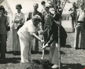
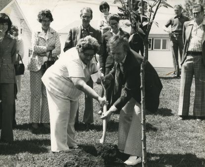
Eastburn Park tree planting
https://search.heritageburnaby.ca/link/archivedescription38626
- Repository
- City of Burnaby Archives
- Date
- June 8, 1976
- Collection/Fonds
- Burnaby Historical Society fonds
- Description Level
- Item
- Physical Description
- 1 photograph : b&w ; 20.5 x 25.5 cm pasted on cardboard backing
- Scope and Content
- Photograph of Jessie Beattie and Burnaby Mayor Tom Constable shoveling dirt onto a tree at a tree planting ceremony at Eastburn Park. Also identified in the photograph is Susan Dunn, who can be seen standing to the far left.
- Repository
- City of Burnaby Archives
- Date
- June 8, 1976
- Collection/Fonds
- Burnaby Historical Society fonds
- Subseries
- Municipal record subseries
- Physical Description
- 1 photograph : b&w ; 20.5 x 25.5 cm pasted on cardboard backing
- Description Level
- Item
- Record No.
- 467-002
- Access Restriction
- No restrictions
- Reproduction Restriction
- No restrictions
- Accession Number
- BHS2004-5
- Scope and Content
- Photograph of Jessie Beattie and Burnaby Mayor Tom Constable shoveling dirt onto a tree at a tree planting ceremony at Eastburn Park. Also identified in the photograph is Susan Dunn, who can be seen standing to the far left.
- Subjects
- Ceremonies
- Officials - Alderman and Councillors
- Officials - Mayors and Reeves
- Geographic Features - Parks
- Media Type
- Photograph
- Notes
- Title based on contents of photograph
- Geographic Access
- Eastburn Park
- 13th Avenue
- Street Address
- 7944 13th Avenue
- Historic Neighbourhood
- East Burnaby (Historic Neighbourhood)
- Planning Study Area
- Second Street Area
Images
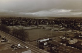
Edmonds School and sports field
https://search.heritageburnaby.ca/link/archivedescription35953
- Repository
- City of Burnaby Archives
- Date
- December 1987
- Collection/Fonds
- Burnaby Historical Society fonds
- Description Level
- Item
- Physical Description
- 1 photograph : sepia ; 12.5 x 17.5 cm print
- Scope and Content
- Photograph of Edmonds Street School, including the sports field, taken from the New Vista Tower.
- Repository
- City of Burnaby Archives
- Date
- December 1987
- Collection/Fonds
- Burnaby Historical Society fonds
- Subseries
- Edmonds School subseries
- Physical Description
- 1 photograph : sepia ; 12.5 x 17.5 cm print
- Description Level
- Item
- Record No.
- 207-002
- Access Restriction
- No restrictions
- Reproduction Restriction
- Reproduce for fair dealing purposes only
- Accession Number
- BHS1988-07
- Scope and Content
- Photograph of Edmonds Street School, including the sports field, taken from the New Vista Tower.
- Names
- Edmonds Community School
- Media Type
- Photograph
- Notes
- Title based on contents of photograph
- Geographic Access
- 18th Avenue
- Street Address
- 7651 18th Avenue
- Historic Neighbourhood
- Edmonds (Historic Neighbourhood)
- Planning Study Area
- Edmonds Area
Images


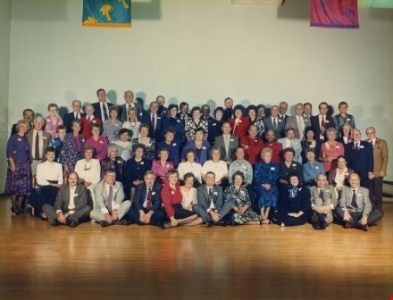
Edmonds School Class Reunion
https://search.heritageburnaby.ca/link/archivedescription38416
- Repository
- City of Burnaby Archives
- Date
- 1989
- Collection/Fonds
- Burnaby Historical Society fonds
- Description Level
- Item
- Physical Description
- 1 photograph : col. ; 20 x 25 cm + 4 p.
- Scope and Content
- Photograph of the members of the grade nine class at Edmonds School from 1949, in 1989, at their 40th reunion.
- Repository
- City of Burnaby Archives
- Date
- 1989
- Collection/Fonds
- Burnaby Historical Society fonds
- Subseries
- Burnaby Retired Teachers subseries
- Physical Description
- 1 photograph : col. ; 20 x 25 cm + 4 p.
- Description Level
- Item
- Record No.
- 434-002
- Access Restriction
- No restrictions
- Reproduction Restriction
- Reproduce for fair dealing purposes only
- Accession Number
- BHS2002-11
- Scope and Content
- Photograph of the members of the grade nine class at Edmonds School from 1949, in 1989, at their 40th reunion.
- Subjects
- Celebrations
- Names
- Edmonds Community School
- Media Type
- Photograph
- Notes
- Title based on contents of photograph
- 4 pages accompanying include an identification key
- Geographic Access
- 18th Avenue
- Street Address
- 7651 18th Avenue
- Historic Neighbourhood
- Edmonds (Historic Neighbourhood)
- Planning Study Area
- Edmonds Area
Images

Empty lot
https://search.heritageburnaby.ca/link/archivedescription38283
- Repository
- City of Burnaby Archives
- Date
- 1987
- Collection/Fonds
- Burnaby Historical Society fonds
- Description Level
- Item
- Physical Description
- 1 photograph : col. ; 8.9 x 11 cm
- Scope and Content
- Photograph of the site of Bonsor Hall, on Fern Avenue, after demolition. A blue car is visible.
- Repository
- City of Burnaby Archives
- Date
- 1987
- Collection/Fonds
- Burnaby Historical Society fonds
- Subseries
- Photographs subseries
- Physical Description
- 1 photograph : col. ; 8.9 x 11 cm
- Description Level
- Item
- Record No.
- 386-002
- Access Restriction
- No restrictions
- Reproduction Restriction
- Reproduce for fair dealing purposes only
- Accession Number
- BHS2007-04
- Scope and Content
- Photograph of the site of Bonsor Hall, on Fern Avenue, after demolition. A blue car is visible.
- Subjects
- Transportation - Automobiles
- Media Type
- Photograph
- Notes
- Title based on contents of photograph
- Geographic Access
- Fern Avenue
- Historic Neighbourhood
- Central Park (Historic Neighbourhood)
- Planning Study Area
- Marlborough Area
Images


Former site of the Kelly Douglas building
https://search.heritageburnaby.ca/link/archivedescription35028
- Repository
- City of Burnaby Archives
- Date
- August 18, 1986
- Collection/Fonds
- Burnaby Historical Society fonds
- Description Level
- Item
- Physical Description
- 1 photograph : col. ; 8.8 x 12.6 cm
- Scope and Content
- Photograph of the site of Kelly Douglas and Co. at 4700 Kingsway after the building was demolished. Buildings and the Skytrain Expo line are visible in the background.
- Repository
- City of Burnaby Archives
- Date
- August 18, 1986
- Collection/Fonds
- Burnaby Historical Society fonds
- Subseries
- Evelyn Salisbury subseries
- Physical Description
- 1 photograph : col. ; 8.8 x 12.6 cm
- Description Level
- Item
- Record No.
- 178-002
- Access Restriction
- No restrictions
- Reproduction Restriction
- Reproduce for fair dealing purposes only
- Accession Number
- BHS1986-26
- Scope and Content
- Photograph of the site of Kelly Douglas and Co. at 4700 Kingsway after the building was demolished. Buildings and the Skytrain Expo line are visible in the background.
- Media Type
- Photograph
- Notes
- Title based on contents of photograph
- Geographic Access
- Kingsway
- Street Address
- 4700 Kingsway
- Historic Neighbourhood
- Central Park (Historic Neighbourhood)
- Planning Study Area
- Maywood Area
Images

![Interurban 1223, [April 9, 1970] thumbnail](/media/hpo/_Data/_Archives_Images/_Unrestricted/316/364-002.jpg?width=280)
Interurban 1223
https://search.heritageburnaby.ca/link/archivedescription37367
- Repository
- City of Burnaby Archives
- Date
- [April 9, 1970]
- Collection/Fonds
- Burnaby Historical Society fonds
- Description Level
- Item
- Physical Description
- 1 photograph : b&w ; 19 x 24 cm
- Scope and Content
- Photograph of the interurban tram on display at Edmonds and Kingsway. A note written at the bottom of the photograph reads: "app. April 9/70" but the date of the photograph may be earlier than 1970.
- Repository
- City of Burnaby Archives
- Date
- [April 9, 1970]
- Collection/Fonds
- Burnaby Historical Society fonds
- Subseries
- Photographs subseries
- Physical Description
- 1 photograph : b&w ; 19 x 24 cm
- Description Level
- Item
- Record No.
- 364-002
- Access Restriction
- No restrictions
- Reproduction Restriction
- Reproduce for fair dealing purposes only
- Accession Number
- BHS2007-04
- Scope and Content
- Photograph of the interurban tram on display at Edmonds and Kingsway. A note written at the bottom of the photograph reads: "app. April 9/70" but the date of the photograph may be earlier than 1970.
- Subjects
- Transportation - Electric Railroads
- Media Type
- Photograph
- Notes
- Title based on contents of photograph
- Geographic Access
- Kingsway
- Edmonds Street
- Historic Neighbourhood
- Edmonds (Historic Neighbourhood)
- Planning Study Area
- Edmonds Area
Images
![Interurban 1223, [April 9, 1970] thumbnail](/media/hpo/_Data/_Archives_Images/_Unrestricted/316/364-002.jpg)
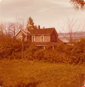
Lubbock's farm house
https://search.heritageburnaby.ca/link/archivedescription36513
- Repository
- City of Burnaby Archives
- Date
- 1977
- Collection/Fonds
- Burnaby Historical Society fonds
- Description Level
- Item
- Physical Description
- 1 photograph : col. ; 9 x 8.5 cm
- Scope and Content
- Photograph of Lubbock's farm house and surrounding trees.
- Repository
- City of Burnaby Archives
- Date
- 1977
- Collection/Fonds
- Burnaby Historical Society fonds
- Subseries
- Lubbock family subseries
- Physical Description
- 1 photograph : col. ; 9 x 8.5 cm
- Description Level
- Item
- Record No.
- 289-002
- Access Restriction
- No restrictions
- Reproduction Restriction
- Reproduce for fair dealing purposes only
- Accession Number
- BHS1992-24
- Scope and Content
- Photograph of Lubbock's farm house and surrounding trees.
- Subjects
- Buildings - Residential - Houses
- Media Type
- Photograph
- Notes
- Title based on contents of photograph
- Geographic Access
- Grandview Highway
- Canada Way
- Burris Street
- Street Address
- 7803 Burris Street
- Historic Neighbourhood
- Burnaby Lake (Historic Neighbourhood)
- Planning Study Area
- Morley-Buckingham Area
Images

![Mathers house, [1970] thumbnail](/media/hpo/_Data/_Archives_Images/_Unrestricted/371/405-002.jpg?width=280)
Mathers house
https://search.heritageburnaby.ca/link/archivedescription38324
- Repository
- City of Burnaby Archives
- Date
- [1970]
- Collection/Fonds
- Burnaby Historical Society fonds
- Description Level
- Item
- Physical Description
- 1 photograph : b&w ; 6.5 x 8.2 cm
- Scope and Content
- Photograph of the Mathers house at Deer Lake, which also served as the Seminary of Christ the King.
- Repository
- City of Burnaby Archives
- Date
- [1970]
- Collection/Fonds
- Burnaby Historical Society fonds
- Subseries
- Photographs subseries
- Physical Description
- 1 photograph : b&w ; 6.5 x 8.2 cm
- Description Level
- Item
- Record No.
- 405-002
- Access Restriction
- No restrictions
- Reproduction Restriction
- Reproduce for fair dealing purposes only
- Accession Number
- BHS2000-5
- Scope and Content
- Photograph of the Mathers house at Deer Lake, which also served as the Seminary of Christ the King.
- Media Type
- Photograph
- Notes
- Title based on contents of photograph
- Geographic Access
- Deer Lake Avenue
- Street Address
- 6490 Deer Lake Avenue
- Historic Neighbourhood
- Burnaby Lake (Historic Neighbourhood)
- Planning Study Area
- Douglas-Gilpin Area
Images
![Mathers house, [1970] thumbnail](/media/hpo/_Data/_Archives_Images/_Unrestricted/371/405-002.jpg)

Naud house
https://search.heritageburnaby.ca/link/archivedescription38295
- Repository
- City of Burnaby Archives
- Date
- 1985
- Collection/Fonds
- Burnaby Historical Society fonds
- Description Level
- Item
- Physical Description
- 1 photograph : b&w ; 12.5 x 17.5 cm
- Scope and Content
- Photograph of the Naud house, at 4737 Victory Street. This home was built by Onzieme Naud and is now a protected heritage site in Burnaby.
- Repository
- City of Burnaby Archives
- Date
- 1985
- Collection/Fonds
- Burnaby Historical Society fonds
- Subseries
- Photographs subseries
- Physical Description
- 1 photograph : b&w ; 12.5 x 17.5 cm
- Description Level
- Item
- Record No.
- 398-002
- Access Restriction
- No restrictions
- Reproduction Restriction
- Reproduce for fair dealing purposes only
- Accession Number
- BHS2007-04
- Scope and Content
- Photograph of the Naud house, at 4737 Victory Street. This home was built by Onzieme Naud and is now a protected heritage site in Burnaby.
- Media Type
- Photograph
- Notes
- Title based on contents of photograph
- Geographic Access
- Victory Street
- Street Address
- 4737 Victory Street
- Historic Neighbourhood
- Alta-Vista (Historic Neighbourhood)
- Planning Study Area
- Sussex-Nelson Area
Images

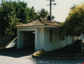
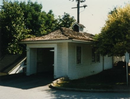
Oakalla Warden's House
https://search.heritageburnaby.ca/link/archivedescription34854
- Repository
- City of Burnaby Archives
- Date
- 1985
- Collection/Fonds
- Burnaby Historical Society fonds
- Description Level
- Item
- Physical Description
- 1 photograph : col. ; 8.8 x 11.3 cm
- Scope and Content
- Photograph of the Warden's house and garage at Oakalla Prison Farm, Royal Oak Road.
- Repository
- City of Burnaby Archives
- Date
- 1985
- Collection/Fonds
- Burnaby Historical Society fonds
- Subseries
- Evelyn Salisbury subseries
- Physical Description
- 1 photograph : col. ; 8.8 x 11.3 cm
- Description Level
- Item
- Record No.
- 145-002
- Access Restriction
- No restrictions
- Reproduction Restriction
- Reproduce for fair dealing purposes only
- Accession Number
- BHS1985-15
- Scope and Content
- Photograph of the Warden's house and garage at Oakalla Prison Farm, Royal Oak Road.
- Names
- Oakalla Prison Farm
- Media Type
- Photograph
- Notes
- Title based on contents of photograph
- Geographic Access
- Oakmount Crescent
- Street Address
- 5220 Oakmount Crescent
- Historic Neighbourhood
- Burnaby Lake (Historic Neighbourhood)
- Planning Study Area
- Oakalla Area
Images