Narrow Results By
Subject
- Advertising Medium - Signs and Signboards 5
- Aerial Photographs 1
- Agriculture 1
- Agriculture - Farms 1
- Buildings - Commercial 4
- Buildings - Commercial - Grocery Stores 3
- Buildings - Commercial - Restaurants 2
- Buildings - Commercial - Stores 1
- Buildings - Heritage 1
- Buildings - Industrial - Mills 1
- Buildings - Residential 30
- Buildings - Residential - Apartments 22

Martello Group sign at 6615 Telford Avenue
https://search.heritageburnaby.ca/link/archivedescription98675
- Repository
- City of Burnaby Archives
- Date
- 2022
- Collection/Fonds
- Disappearing Burnaby collection
- Description Level
- Item
- Physical Description
- 1 photograph (jpeg) : col.
- Scope and Content
- Photograph of a sign, which reads "Professionally Managed by Martello," on the lawn of an apartment building located at 6615 Telford Avenue. The building was constructed in 1964. Other residential towers, a construction crane, and cars parked along Telford Avenue are visible in the background.
- Repository
- City of Burnaby Archives
- Date
- 2022
- Collection/Fonds
- Disappearing Burnaby collection
- Physical Description
- 1 photograph (jpeg) : col.
- Description Level
- Item
- Record No.
- 634-022
- Access Restriction
- No restrictions
- Reproduction Restriction
- No restrictions
- Accession Number
- 2022-14
- Scope and Content
- Photograph of a sign, which reads "Professionally Managed by Martello," on the lawn of an apartment building located at 6615 Telford Avenue. The building was constructed in 1964. Other residential towers, a construction crane, and cars parked along Telford Avenue are visible in the background.
- Subjects
- Buildings - Residential
- Buildings - Residential - Apartments
- Advertising Medium - Signs and Signboards
- Media Type
- Photograph
- Photographer
- Cheung, Nakita
- Notes
- Title taken from the associated blog post
- Associated blog post: https://disappearingburnaby.wordpress.com/2022/06/09/martello-group/
- Geographic Access
- Telford Avenue
- Street Address
- 6615 Telford Avenue
- Historic Neighbourhood
- Central Park (Historic Neighbourhood)
- Planning Study Area
- Maywood Area
Images

![Midge Bowen, P. Lauchlani and unidentified woman, [between 1940 and 1960] thumbnail](/media/hpo/_Data/_Archives_Images/_Unrestricted/550/550-255.jpg?width=280)
Midge Bowen, P. Lauchlani and unidentified woman
https://search.heritageburnaby.ca/link/archivedescription82728
- Repository
- City of Burnaby Archives
- Date
- [between 1940 and 1960]
- Collection/Fonds
- Hill family and Vidal family fonds
- Description Level
- Item
- Physical Description
- 1 photograph : sepia, mounted on black construction paper ; 9 x 11.5 cm
- Scope and Content
- Photograph is a portrait of three women identified from left to right as Miss. Spohn, Midge Bowen and P. Laughlani. They are sitting near a cabin and a body of water is visible in the background.
- Repository
- City of Burnaby Archives
- Date
- [between 1940 and 1960]
- Collection/Fonds
- Hill family and Vidal family fonds
- Physical Description
- 1 photograph : sepia, mounted on black construction paper ; 9 x 11.5 cm
- Description Level
- Item
- Record No.
- 550-255
- Access Restriction
- No restrictions
- Reproduction Restriction
- No restrictions
- Accession Number
- 2013-03
- Scope and Content
- Photograph is a portrait of three women identified from left to right as Miss. Spohn, Midge Bowen and P. Laughlani. They are sitting near a cabin and a body of water is visible in the background.
- Subjects
- Buildings - Residential - Cabins
- Media Type
- Photograph
- Notes
- Title based on note accompanying photograph
- Note in pencil on paper reads: "... Spohn - Midge Bowen - P Laughlani"
Images
![Midge Bowen, P. Lauchlani and unidentified woman, [between 1940 and 1960] thumbnail](/media/hpo/_Data/_Archives_Images/_Unrestricted/550/550-255.jpg)
Nancy Peter subseries
https://search.heritageburnaby.ca/link/archivedescription97449
- Repository
- City of Burnaby Archives
- Date
- 1952-1992
- Collection/Fonds
- Burnaby Historical Society fonds
- Description Level
- Subseries
- Physical Description
- Photographs and textual records
- Scope and Content
- Subseries consists of photographs of Burnaby Lake compiled by Nancy Peter. Subseries also contains one school report: "A Study of Burnaby taken from the Point of View of Education."
- Repository
- City of Burnaby Archives
- Date
- 1952-1992
- Collection/Fonds
- Burnaby Historical Society fonds
- Subseries
- Nancy Peter subseries
- Physical Description
- Photographs and textual records
- Description Level
- Subseries
- Accession Number
- BHS1992-45
- BHS1992-40
- Scope and Content
- Subseries consists of photographs of Burnaby Lake compiled by Nancy Peter. Subseries also contains one school report: "A Study of Burnaby taken from the Point of View of Education."
- History
- Nancy M. Bailey was the vice principal of Lord Tweedsmeer Hight School in Cloverdale, BC. In 1941, she met Laurence J. Peter, an industrial arts teacher at the school. In 1943 the couple married and in 1947 they moved to Burnaby. Laurence and Nancy had four children: two boys, John and Ted, and two girls, Alice and Margaret. The family was actively involved in the Burnaby community with Laurence and Nancy taking part in local politics and community activities and their children participating in Boy Scouts and Girl Guides and music lessons. All four children graduated from Burnaby North High School and in 1970, Ted and Alice completed their studies at British Columbia Institute of Technology (BCIT). They worked local jobs in the community including on the construction of the Burnaby Mountain Golf Course. Laurence worked as a Mental Health Coordinator (Special Counselor) in the Vancouver School System and in 1959, Nancy joined the staff at the newly opened Burnaby Central Senior Secondary School as a Math teacher. She later became the head of the Mathematics Department at the school. The couple continued their education at summer school at Washington State University in Pullman, Washington, where Nancy completed her Masters Degree in 1964 and Laurence his Doctoral degree in 1963. Laurence joined the faculty of the University of British Columbia in 1965 and received the WSU Regents’ Distinguished Alumnus Award in 1980. The couple separated in 1965 and Laurence moved to California in 1966 to teach at the University of Southern California. Nancy continued to teach at Burnaby South, until her retirement in 1978 after 30 years as head of the Mathematics Department at Burnaby Central. She was an active member of the Burnaby Historical Society for many years. Nancy passed away in Nanaimo near her family on April 21, 2013 at the age of 97.
- Media Type
- Photograph
- Textual Record
- Creator
- Peter, Nancy M. Bailey
- Notes
- Title based on creator of subseries
![Ontario Place, [1969?] thumbnail](/media/hpo/_Data/_BVM_Images/2013/2013_0012_0051_001.jpg?width=280)
Ontario Place
https://search.heritageburnaby.ca/link/museumdescription3694
- Repository
- Burnaby Village Museum
- Date
- [1969?]
- Collection/Fonds
- Harold Edward Winch collection
- Description Level
- Item
- Physical Description
- 1 photograph : b&w ; 12.8 x 17.8 cm
- Scope and Content
- Item is a photograph of a construction site at Ontario Place including five men and one woman. The men include Harold Winch and Dr. Gurdial Singh Dhillon, a member of Indian Parliament; the woman is identified as "Jean McPherson, CPA official." CPA most likely refers to the Commonwealth Parliamenta…
- Repository
- Burnaby Village Museum
- Collection/Fonds
- Harold Edward Winch collection
- Description Level
- Item
- Physical Description
- 1 photograph : b&w ; 12.8 x 17.8 cm
- Scope and Content
- Item is a photograph of a construction site at Ontario Place including five men and one woman. The men include Harold Winch and Dr. Gurdial Singh Dhillon, a member of Indian Parliament; the woman is identified as "Jean McPherson, CPA official." CPA most likely refers to the Commonwealth Parliamentary Association.
- Subjects
- Government - Federal Government
- Names
- Winch, Harold Edward
- Accession Code
- BV013.12.51
- Date
- [1969?]
- Media Type
- Photograph
- Related Material
- See photograph BV013.12.74.
- Notes
- Title based on contents of photograph
- Photograph is a part of original scrapbook Item BV013.12.11
Images
![Ontario Place, [1969?] thumbnail](/media/hpo/_Data/_BVM_Images/2013/2013_0012_0051_001.jpg)
Paneloc Marketing Ltd. business records series
https://search.heritageburnaby.ca/link/museumdescription15112
- Repository
- Burnaby Village Museum
- Date
- 1957-1973
- Collection/Fonds
- Elmer Wilson Martin fonds
- Description Level
- Series
- Physical Description
- 10 photographs + 9 architectural drawings + approx. 2 cm of textual records
- Scope and Content
- Series consists of business records relating to Elmer Wilson Martin's involvement with Paneloc Marketing Ltd. including business cards; architectural drawings of various building models; correspondence; reports; price lists; quotes and photographs of completed paneloc buildings and buildings under …
- Repository
- Burnaby Village Museum
- Collection/Fonds
- Elmer Wilson Martin fonds
- Description Level
- Series
- Physical Description
- 10 photographs + 9 architectural drawings + approx. 2 cm of textual records
- Scope and Content
- Series consists of business records relating to Elmer Wilson Martin's involvement with Paneloc Marketing Ltd. including business cards; architectural drawings of various building models; correspondence; reports; price lists; quotes and photographs of completed paneloc buildings and buildings under construction. Series also includes an Elections poster when E.W. Martin ran for Reeve of Burnaby in 1959.
- Accession Code
- BV019.37; BV019.40
- Date
- 1957-1973
- Media Type
- Photograph
- Textual Record
- Architectural Drawing
- Notes
- Title based on contents of series
Planning Department fonds
https://search.heritageburnaby.ca/link/archivedescription102
- Repository
- City of Burnaby Archives
- Date
- 1940-2016
- Collection/Fonds
- Planning Department fonds
- Description Level
- Fonds
- Physical Description
- 80 m of textual records and other material
- Scope and Content
- Fonds consists of those records created during the regular conduct of business by the Planning Department and its predecessor agencies according to their mandate of providing professional and technical advice to Council on the current and future uses of City land and resources.
- Repository
- City of Burnaby Archives
- Date
- 1940-2016
- Collection/Fonds
- Planning Department fonds
- Physical Description
- 80 m of textual records and other material
- Description Level
- Fonds
- File Class
- 71000 10 (add. 2020)
- 71000 20 (add. 2020)
- 71000 30 (add. 2020)
- 71000 40 (add. 2020)
- Access Restriction
- Subject to FOIPPA
- Reproduction Restriction
- Reproductions subject to FOIPPA.
- Scope and Content
- Fonds consists of those records created during the regular conduct of business by the Planning Department and its predecessor agencies according to their mandate of providing professional and technical advice to Council on the current and future uses of City land and resources.
- History
- The City of Burnaby Planning Department was established on October 9, 1956, when the City Council unanimously carried the motion to create a distinct department to deal with planning issues within the City and appointed Mr. William John Blakely as its head. This decision followed a report and recommendation made by the City’s Chief Administrative Officer which indicated that the role of the Planning Engineer and his staff had quickly expanded to become a separate division within the Engineering Department and that they were functioning as an independent unit in all but name. The proposed separation of the Engineering and Planning departments had been in the works since the early part of 1956 when staff changes and restructuring within the Engineering Department’s Planning Division illustrated the undermanned condition of the Planning Engineer’s office. As a result, Council asked the Chief Administrative Officer to undertake a study examining the feasibility of creating a distinct Planning Department. This report was delivered to Council on July 3, 1956, but was laid over until a Committee of the Council had the opportunity to study the functions of the Planning department to determine the necessity of the proposal. The Committee’s findings were in line with the initial report and the Planning Department was established with a staff of nine (the head Planning Engineer, an Administrative Planner, three Research Planning Assistants, a Draughtsman, a Subdivision Control Clerk, a department Clerk and a Clerk Stenographer). This new department was to offer advice and carry out the work intensive in matters such as zoning and rezoning applications, subdivision control, traffic and transportation planning, and general City planning schemes. Prior to the creation of the Planning Department, a number of bodies within the City had been responsible for fulfilling the functions carried out by this new unit. In the earliest years of the City, the members of Council were responsible for matters of planning and were assisted in their job by the City’s Engineer or any number of hired consultants (e.g. surveyors, cartographers). By 1906, however, the provincial laws surrounding the subdivision process had changed, and local governments were charged with the task of approving all private subdivision plans in their respective Municipalities. In Burnaby, the City Council passed a bylaw decreeing that all subdivision plans were to be submitted to Council for review and the City Engineer was responsible for ensuring compliance with the law. After the first Town Planning Bylaw in 1924 which restricted the type and size of construction that could occur in certain City areas, the Engineering and Building departments were to work together to oversee the enforcement of the Bylaw and the development of City plans. The scope and competence required to carry out this work grew as Burnaby’s population expanded, and in 1930 Council passed the Town Planning Commission Bylaw (No. 1028) that saw the creation of a permanent body – the Town Planning Commission – which was to serve as an advisory body to help direct the planning activities in the City while the actual work continued to be carried out by the Engineering Department. This body was comprised of the Reeve, the Chairman of the School Board, the Chairman of the Park Committee (later, the Board of Parks Commissioners), and six appointed citizens who served three-year terms. Council referred all matters of subdivisions, transportation planning, and rezoning to this Commission, which was later supported in its work by several other special or standing committees such as the Subdivision Committee, the Apartment Committee, the Transportation Committee or the Town Planning Board of Appeal. By 1953, it had become apparent that the advisory committees that were dedicated to these planning issues needed a permanent staff to carry out the work intensive, so a restructuring of the Engineering department resulted in a permanent Planning Engineer’s office being created. The Town Planning Commission continued in its advisory capacity even after the determination came in 1956 to create a separate Planning Department. When Bylaw No. 4473 was passed in 1963, the Town Planning Commission was disbanded in favour of a new Advisory Planning Commission that would turn over all routine matters such as subdivision and rezoning applications to the Planning Department but would offer advice and community input into the more complex planning schemes within the City and act as an intermediary in cases where Council and Planning staff were in disagreement. A new Advisory Planning Commission Bylaw (No. 7600) was adopted in 1980 which allowed for even greater community participation in the planning process. The Planning Department was initially responsible to report directly to Council, but in 1957, the administrative structure of Municipal staff changed with the introduction of the Burnaby Municipal Manager Bylaw (No. 3859) and from that point on, the head of the Planning Department held a direct reporting relationship to the Municipal Manager, who in turn was responsible for reporting the activities of the Department to the City Council. Over the years, the internal structure and the scope of responsibilities of the Department have changed during periods of staff reorganizations. Under the larger umbrella of the Planning and Building Department, Planning has come to be comprised of two divisions: the Current Planning Division and the Long Range Planning Division. The functions of the Current Planning Division include rezoning, subdivision, development plan areas, preliminary plan approvals, urban design, heritage planning, and urban trails and bicycle routes. The Long Range Planning Division is responsible for environmental planning concerns, transportation planning, housing, neighbourhood area planning, social planning and planning information services. In 2022, the Planning and Building Department was reorganized to better align functions with delivery of services. The Climate Action and Engery Division moved from Corporate Services to the Planning and Building Department, while Indigenous Relations and Facilities Management moved to Corporate Services and Lands and Facilities, respectively. The position of Director of Planning and Building was changed to General Manager, Planning and Development. The following individuals have served as Planning Engineer and/or Director of the Planning Department and/or General Manager, Planning and Development for the City of Burnaby: William John Blakely 1954-1956 (as Planning Engineer) 1956-1963 (as Head of the Department) Anthony P. Parr 1964-1993 Don G. Stenson 1993-2001 Jack S. Belhouse 2001-2006 Basil Luksun 2006-2012 Lou Pelletier 2012-2019 Edward Kozak 2019-present
- Formats
- Microforms exist for some records. See series descriptions.
- Media Type
- Textual Record
- Photograph
- Moving Images
- Creator
- City of Burnaby
- Notes
- Title based on contents of fonds
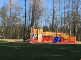
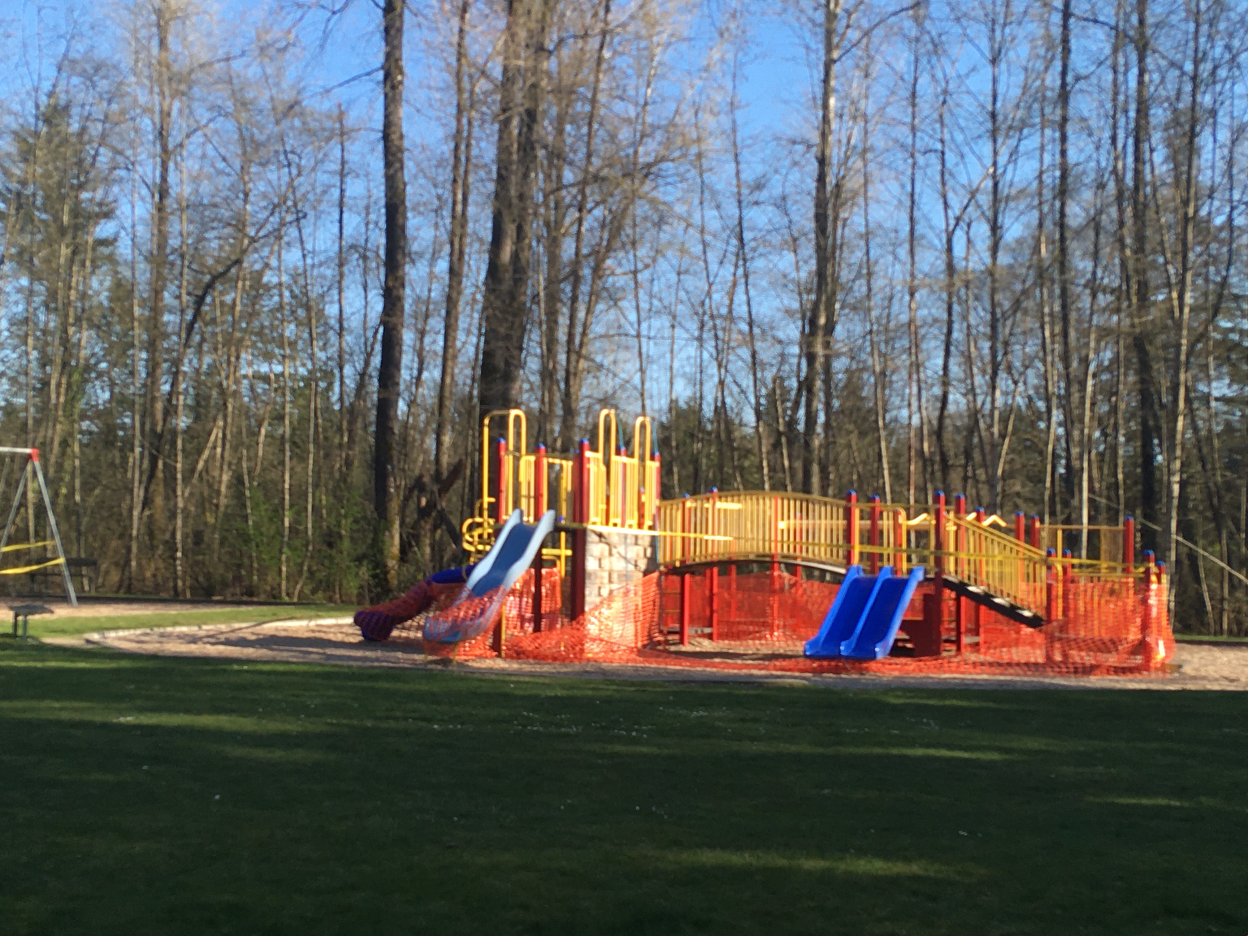
Playground in Squint Lake Park
https://search.heritageburnaby.ca/link/museumdescription14736
- Repository
- Burnaby Village Museum
- Date
- 9 Apr. 2020
- Collection/Fonds
- Burnaby Village Museum COVID-19 collection
- Description Level
- Item
- Physical Description
- 1 photograph (jpg) : col. ; 72 dpi.
- Scope and Content
- Photograph of the Squint Lake Park playground. The playground equipment is surrounded by orange construction fencing to prevent childlren from playing on it. The playground was closed down by the City of Burnaby in the spring of 2020 due to the COVID-19 pandemic and public health orders.
- Repository
- Burnaby Village Museum
- Collection/Fonds
- Burnaby Village Museum COVID-19 collection
- Description Level
- Item
- Physical Description
- 1 photograph (jpg) : col. ; 72 dpi.
- Scope and Content
- Photograph of the Squint Lake Park playground. The playground equipment is surrounded by orange construction fencing to prevent childlren from playing on it. The playground was closed down by the City of Burnaby in the spring of 2020 due to the COVID-19 pandemic and public health orders.
- History
- Tristan Johnson took photos around Burnaby because as a parent of two elementary school aged children during the COVID-19 pandemic, one of the most notable things about COVID-19 during Spring 2020 was the closure of playgrounds and the playgrounds being taped up.
- Accession Code
- BV020.21.1
- Access Restriction
- No restrictions
- Reproduction Restriction
- No known restrictions
- Date
- 9 Apr. 2020
- Media Type
- Photograph
- Planning Study Area
- Sperling-Broadway Area
- Photographer
- Johnson, Tristan
- Notes
- Title based on contents of photograph
Images
Riverway West School PTA scrapbook
https://search.heritageburnaby.ca/link/archivedescription58351
- Repository
- City of Burnaby Archives
- Date
- 1923-1967
- Collection/Fonds
- Burnaby Historical Society fonds
- Description Level
- Item
- Physical Description
- 1 scrapbook
- Scope and Content
- Item is a scrapbook created by the Riverway West School Parent-Teachers' Association. Included in the scrapbook are photographs, correspondence, reports and newspaper clippings. Documents and photos within are related to Burnaby's first May Days including the first programme and May Queen photograp…
- Repository
- City of Burnaby Archives
- Date
- 1923-1967
- Collection/Fonds
- Burnaby Historical Society fonds
- Physical Description
- 1 scrapbook
- Material Details
- Scrapbook is a binder made of wood with construction paper pages housed inside plastic sheets
- Description Level
- Item
- Record No.
- MSS068-001
- Access Restriction
- No restrictions
- Reproduction Restriction
- No known restrictions
- Accession Number
- BHS1992-03
- Scope and Content
- Item is a scrapbook created by the Riverway West School Parent-Teachers' Association. Included in the scrapbook are photographs, correspondence, reports and newspaper clippings. Documents and photos within are related to Burnaby's first May Days including the first programme and May Queen photograph, the formation of the Riverway Park, PTA functions, members, Riverway West student photographs. The scrapbook was created by the 1960-1961 PTA members, notably: Mrs. Emily Eichler, Historian; Mrs. C.L. James, Assistant Historian; Mrs. Gordon Dowding, Photographer; and Mr. Rod Beaton, who designed the cover. The design on the wooden cover of the scrapbook was burned into the wood by Mrs. Eichler's son using a magnifying glass. The last page was added in 1967 or later.
- Media Type
- Textual Record
- Photograph
Robert Bailey fonds
https://search.heritageburnaby.ca/link/archivedescription66714
- Repository
- City of Burnaby Archives
- Date
- 1965-1970
- Collection/Fonds
- Robert Bailey fonds
- Description Level
- Fonds
- Physical Description
- 39 photographs : col. slides ; 35 mm
- Scope and Content
- Fonds consists of photographs of the construction and opening of the Burnaby Mountain Golf Course, taken by Robert Bailey.
- Repository
- City of Burnaby Archives
- Date
- 1965-1970
- Collection/Fonds
- Robert Bailey fonds
- Physical Description
- 39 photographs : col. slides ; 35 mm
- Description Level
- Fonds
- Access Restriction
- No restrictions
- Accession Number
- 2011-14
- Scope and Content
- Fonds consists of photographs of the construction and opening of the Burnaby Mountain Golf Course, taken by Robert Bailey.
- History
- Robert Bailey worked as the Parks Superintendent in Burnaby until 1975. He died in 2002.
- Media Type
- Photograph
- Creator
- Bailey, Robert
- Notes
- Title based on contents of fonds
- Photo catalogue 526
![Simon Fraser University, [196-] (date of original), copied 1991 thumbnail](/media/hpo/_Data/_Archives_Images/_Unrestricted/370/370-801.jpg?width=280)
Simon Fraser University
https://search.heritageburnaby.ca/link/archivedescription38214
- Repository
- City of Burnaby Archives
- Date
- [196-] (date of original), copied 1991
- Collection/Fonds
- Burnaby Historical Society fonds
- Description Level
- Item
- Physical Description
- 1 photograph : b&w ; 3.1 x 4.5 cm print on contact sheet 20.5 x 26.8 cm
- Scope and Content
- Aerial photograph of the Simon Fraser University (SFU) Burnaby campus under construction, facing west.
- Repository
- City of Burnaby Archives
- Date
- [196-] (date of original), copied 1991
- Collection/Fonds
- Burnaby Historical Society fonds
- Subseries
- Burnaby Image Bank subseries
- Physical Description
- 1 photograph : b&w ; 3.1 x 4.5 cm print on contact sheet 20.5 x 26.8 cm
- Description Level
- Item
- Record No.
- 370-801
- Access Restriction
- No restrictions
- Reproduction Restriction
- Reproduce for fair dealing purposes only
- Accession Number
- BHS1999-03
- Scope and Content
- Aerial photograph of the Simon Fraser University (SFU) Burnaby campus under construction, facing west.
- Media Type
- Photograph
- Notes
- Title based on contents of photograph
- 1 b&w copy negative accompanying
- Geographic Access
- Burnaby Mountain Conservation Area
- University Drive
- Street Address
- 8888 University Drive
- Planning Study Area
- Burnaby Mountain Area
Images
![Simon Fraser University, [196-] (date of original), copied 1991 thumbnail](/media/hpo/_Data/_Archives_Images/_Unrestricted/370/370-801.jpg)
![Unidentifed man holding a golf club, [between 1940 and 1960] thumbnail](/media/hpo/_Data/_Archives_Images/_Unrestricted/550/550-256.jpg?width=280)
Unidentifed man holding a golf club
https://search.heritageburnaby.ca/link/archivedescription82729
- Repository
- City of Burnaby Archives
- Date
- [between 1940 and 1960]
- Collection/Fonds
- Hill family and Vidal family fonds
- Description Level
- Item
- Physical Description
- 1 photograph : sepia, mounted on construction paper ; 14 x 8.5 cm
- Scope and Content
- Photograph is a portrait of an unidentified man leaning on a golf club.
- Repository
- City of Burnaby Archives
- Date
- [between 1940 and 1960]
- Collection/Fonds
- Hill family and Vidal family fonds
- Physical Description
- 1 photograph : sepia, mounted on construction paper ; 14 x 8.5 cm
- Description Level
- Item
- Record No.
- 550-256
- Access Restriction
- No restrictions
- Reproduction Restriction
- No restrictions
- Accession Number
- 2013-03
- Scope and Content
- Photograph is a portrait of an unidentified man leaning on a golf club.
- Subjects
- Recreational Activities - Golf
- Media Type
- Photograph
- Notes
- Title based on contents of photograph
Images
![Unidentifed man holding a golf club, [between 1940 and 1960] thumbnail](/media/hpo/_Data/_Archives_Images/_Unrestricted/550/550-256.jpg)

Rooted : Chinese Canadian stories in Burnaby
https://search.heritageburnaby.ca/link/museumlibrary7646
- Repository
- Burnaby Village Museum
- Collection
- Digital Reference Collection
- Material Type
- Digital Resource
- ISBN
- 978-0-9689849-2-5
- Call Number
- 971.133 ROO
- Contributor
- Fong, Denise
- Lemke, Jane
- Codd, Lisa
- Place of Publication
- Burnaby
- Publisher
- City of Burnaby
- Publication Date
- 2023
- Printer
- Metropolitan Fine Printers
- Physical Description
- 203 p. : ill. ; 30.5 cm
- Library Subject (LOC)
- Chinese Canadians--British Columbia--Burnaby--History
- Race discrimination -- Canada
- Subjects
- Persons - Chinese Canadians
- Agriculture
- Agriculture - Farms
- Persons - Families
- Rights
- Rights - Human Rights
- Social Issues
- Social Issues - Racism
- Notes
- There are two versions of the book: English and Simplified Chinese (left, below) and the other in English and Traditional Chinese (right, below).
- From the late 1800s to the present day, Chinese Canadians have made Burnaby into a more vibrant and livable city. Rooted: Chinese Canadian Stories in Burnaby brings together a collection of diverse stories and photographs from the community, celebrating the legacy and contributions of Burnaby’s Chinese Canadian community spanning over a century. This coffee-table book features oral histories and interviews with descendants of multigenerational family farms, green grocers, corner stores, restaurants, and places of worship. Also included are archival research and community perspectives on anti-Asian racism, community activism, courage, and resilience.
- The publication has been timed to coincide with the 100th anniversary of the introduction of the Chinese Exclusion Act by the Government of Canada in 1923. This federal legislation followed decades of discriminatory legislation by Canada’s federal, provincial and municipal governments that targeted Chinese Canadians by limiting opportunities to live, work and raise families in Canada. The Chinese Exclusion Act banned almost all migration from China and remained in place until 1947. Publishing this book in 2023 is an effort by the City of Burnaby to recognize the impact of discriminatory legislation on Chinese Canadians in our community, including discriminatory bylaws and practices implemented by Burnaby’s early municipal government.
- Edited by Denise Fong (Lead Researcher), Jane Lemke (Burnaby Village Museum Curator) and Lisa Codd (City of Burnaby Heritage Planner).
Images

Digital Books
South Burnaby Garden Club subseries
https://search.heritageburnaby.ca/link/archivedescription121
- Repository
- City of Burnaby Archives
- Date
- 1915-2009
- Collection/Fonds
- Burnaby Historical Society fonds
- Description Level
- Subseries
- Physical Description
- Textual records and 1 photograph
- Scope and Content
- Subseries consists of the administrative records of the South Burnaby Garden Club from their early beginnings as the Central Park Agricultural Association and Farmer's Institute (1901-1926), the South Burnaby Horticultural Association and Farmers Institute (1927-1957) to the early 2000s.
- Repository
- City of Burnaby Archives
- Date
- 1915-2009
- Collection/Fonds
- Burnaby Historical Society fonds
- Subseries
- South Burnaby Garden Club subseries
- Physical Description
- Textual records and 1 photograph
- Description Level
- Subseries
- Accession Number
- BHS1986-36
- BHS2008-17
- Scope and Content
- Subseries consists of the administrative records of the South Burnaby Garden Club from their early beginnings as the Central Park Agricultural Association and Farmer's Institute (1901-1926), the South Burnaby Horticultural Association and Farmers Institute (1927-1957) to the early 2000s.
- History
- The South Burnaby Garden Club as formed in 1901 after a group of Central Park residents met to form a Farmers’ Institute. They leased 17 acres of Central Park from the Provincial Government and with the support of government grants constructed a two-story building on the property. The building was constructed in time for the first annual Fall Fair in September 1901. In 1903 the Institute amalgamated with the South Vancouver and Burnaby Agricultural Society to become the Central Park Agricultural Association & Farmers Institute. In 1907 the membership doubled to 520 members. Increasing urbanization and the First World War saw the last exhibition in 1919. The lease on the building expired in 1921. The Society continued to meet and hold small exhibitions in rented halls under the South Burnaby Horticultural Association name. After several name changes, the association became the South Burnaby Garden Club in 1958 and continues to this day.
- Media Type
- Photograph
- Textual Record
- Creator
- South Burnaby Garden Club
- Notes
- PC223, PC488, MSS028
- Title based on creator and contents of subseries
1962 Ford Galaxie registered owner's manual and owner service policy
https://search.heritageburnaby.ca/link/museumlibrary6414
- Repository
- Burnaby Village Museum
- Collection
- Special Collection
- Material Type
- Book
- Accession Code
- HV972.35.94
- Call Number
- 629.2 FOR
- Edition
- Fifth ed.
- Place of Publication
- Oakville, Ont.
- Publisher
- Ford Motor Co. of Canada
- Publication Date
- 1962
- Printer
- Sumner Printing
- Inscription
- "J. H. Robins 3525 Dover St Burnaby BC" [handwritten on cover in blue ink] "Champion - F - 11 - Y Autolite BF - 42 .032-.036 .014.016" [handwritten in pencil on back cover]
- Library Subject (LOC)
- Automobiles--Handbooks, manuals, etc.
- Ford automobiles--Handbooks, manuals, etc.
- Names
- Ford Motor Company
- Object History
- The tools included in this donation belonged to Samuel Robins. Samuel and his wife Sarah Ann Robins moved to Burnaby in 1918. Samuel was a stonemason who worked on many projects in the Lower Mainland, including constructing houses in Shaughnessy and he also worked in the Vancouver City Hall.

3955 Moscrop Street
https://search.heritageburnaby.ca/link/archivedescription98654
- Repository
- City of Burnaby Archives
- Date
- 2021
- Collection/Fonds
- Disappearing Burnaby collection
- Description Level
- Item
- Physical Description
- 1 photograph (jpeg) : col.
- Scope and Content
- Photograph of the exterior of a house located at 3955 Moscrop Street. The house was constructed in 1954. The photograph depicts the house at night, with the house's porch light on, and a car is in the driveway in front of the house.
- Repository
- City of Burnaby Archives
- Date
- 2021
- Collection/Fonds
- Disappearing Burnaby collection
- Physical Description
- 1 photograph (jpeg) : col.
- Description Level
- Item
- Record No.
- 634-001
- Access Restriction
- No restrictions
- Reproduction Restriction
- No restrictions
- Accession Number
- 2022-14
- Scope and Content
- Photograph of the exterior of a house located at 3955 Moscrop Street. The house was constructed in 1954. The photograph depicts the house at night, with the house's porch light on, and a car is in the driveway in front of the house.
- Media Type
- Photograph
- Photographer
- Cheung, Nakita
- Notes
- Title taken from the associated blog post
- Associated blog post: https://disappearingburnaby.wordpress.com/2022/02/24/moscrop-house/
- Geographic Access
- Moscrop Street
- Street Address
- 3955 Moscrop Street
- Historic Neighbourhood
- Broadview (Historic Neighbourhood)
- Planning Study Area
- Cascade-Schou Area
Images


5130 Irving Street
https://search.heritageburnaby.ca/link/archivedescription98671
- Repository
- City of Burnaby Archives
- Date
- 2022
- Collection/Fonds
- Disappearing Burnaby collection
- Description Level
- Item
- Physical Description
- 1 photograph (jpeg) : col.
- Scope and Content
- Photograph of the front steps and the entrance of a three-storey apartment building located at 5130 Irving Street. The photograph depicts the building at night, with the lobby and some of the apartments' windows illuminated from inside. The building was constructed in 1971.
- Repository
- City of Burnaby Archives
- Date
- 2022
- Collection/Fonds
- Disappearing Burnaby collection
- Physical Description
- 1 photograph (jpeg) : col.
- Description Level
- Item
- Record No.
- 634-018
- Access Restriction
- No restrictions
- Reproduction Restriction
- No restrictions
- Accession Number
- 2022-14
- Scope and Content
- Photograph of the front steps and the entrance of a three-storey apartment building located at 5130 Irving Street. The photograph depicts the building at night, with the lobby and some of the apartments' windows illuminated from inside. The building was constructed in 1971.
- Media Type
- Photograph
- Photographer
- Cheung, Nakita
- Notes
- Title taken from the associated blog post
- Associated blog post: https://disappearingburnaby.wordpress.com/2022/05/04/e-just-e/
- Geographic Access
- Irving Street
- Street Address
- 5130 Irving Street
- Historic Neighbourhood
- Central Park (Historic Neighbourhood)
- Planning Study Area
- Marlborough Area
Images


5130 Irving Street lobby
https://search.heritageburnaby.ca/link/archivedescription98672
- Repository
- City of Burnaby Archives
- Date
- 2022
- Collection/Fonds
- Disappearing Burnaby collection
- Description Level
- Item
- Physical Description
- 1 photograph (jpeg) : col.
- Scope and Content
- Photograph of the entrance of an apartment building located at 5130 Irving Street. The building was constructed in 1971. The photograph depicts the entrance and the lobby from the exterior at night. The lobby is illuminated and a crest featuring an "E" is on the entrance window.
- Repository
- City of Burnaby Archives
- Date
- 2022
- Collection/Fonds
- Disappearing Burnaby collection
- Physical Description
- 1 photograph (jpeg) : col.
- Description Level
- Item
- Record No.
- 634-019
- Access Restriction
- No restrictions
- Reproduction Restriction
- No restrictions
- Accession Number
- 2022-14
- Scope and Content
- Photograph of the entrance of an apartment building located at 5130 Irving Street. The building was constructed in 1971. The photograph depicts the entrance and the lobby from the exterior at night. The lobby is illuminated and a crest featuring an "E" is on the entrance window.
- Media Type
- Photograph
- Photographer
- Cheung, Nakita
- Notes
- Title taken from the associated blog post
- Associated blog post: https://disappearingburnaby.wordpress.com/2022/05/04/e-just-e/
- Geographic Access
- Irving Street
- Street Address
- 5130 Irving Street
- Historic Neighbourhood
- Central Park (Historic Neighbourhood)
- Planning Study Area
- Marlborough Area
Images


5990 Irmin Street
https://search.heritageburnaby.ca/link/archivedescription98685
- Repository
- City of Burnaby Archives
- Date
- 2022
- Collection/Fonds
- Disappearing Burnaby collection
- Description Level
- Item
- Physical Description
- 1 photograph (jpeg) : col.
- Scope and Content
- Photograph of a multi-storey house located at 5990 Irmin Street. The photograph depicts of the exterior of the house at dusk; a light is on in one of the house's rooms and a vehicle is parked in the house's driveway next to a portable garage. A "For Sale" sign on the edge of the property reads: "Fu…
- Repository
- City of Burnaby Archives
- Date
- 2022
- Collection/Fonds
- Disappearing Burnaby collection
- Physical Description
- 1 photograph (jpeg) : col.
- Description Level
- Item
- Record No.
- 634-032
- Access Restriction
- No restrictions
- Reproduction Restriction
- No restrictions
- Accession Number
- 2022-14
- Scope and Content
- Photograph of a multi-storey house located at 5990 Irmin Street. The photograph depicts of the exterior of the house at dusk; a light is on in one of the house's rooms and a vehicle is parked in the house's driveway next to a portable garage. A "For Sale" sign on the edge of the property reads: "Future Development Land." Another house is visible in the background. The house was constructed in 1923 and is nearby to 7530 Buller Avenue.
- Media Type
- Photograph
- Photographer
- Cheung, Nakita
- Notes
- Title taken from the associated blog post
- Associated blog post: https://disappearingburnaby.wordpress.com/2022/06/30/william-esther-burdick-residence/
- Geographic Access
- Irmin Street
- Street Address
- 5990 Irmin Street
- Historic Neighbourhood
- Alta Vista (Historic Neighbourhood)
- Planning Study Area
- Clinton-Glenwood Area
Images


6280 Marlborough Avenue
https://search.heritageburnaby.ca/link/archivedescription98673
- Repository
- City of Burnaby Archives
- Date
- 2022
- Collection/Fonds
- Disappearing Burnaby collection
- Description Level
- Item
- Physical Description
- 1 photograph (jpeg) : col.
- Scope and Content
- Photograph of the front steps and entry to a three-storey apartment building, located at 6280 Marlborough Avenue. The photograph depicts the building at night and shows the brick building's details, including its lion statues and busts along the stair railings and the curved arches in front of the …
- Repository
- City of Burnaby Archives
- Date
- 2022
- Collection/Fonds
- Disappearing Burnaby collection
- Physical Description
- 1 photograph (jpeg) : col.
- Description Level
- Item
- Record No.
- 634-020
- Access Restriction
- No restrictions
- Reproduction Restriction
- No restrictions
- Accession Number
- 2022-14
- Scope and Content
- Photograph of the front steps and entry to a three-storey apartment building, located at 6280 Marlborough Avenue. The photograph depicts the building at night and shows the brick building's details, including its lion statues and busts along the stair railings and the curved arches in front of the front windows and door. The building was constructed in 1973.
- Media Type
- Photograph
- Photographer
- Cheung, Nakita
- Notes
- Title taken from the associated blog post
- Associated blog post: https://disappearingburnaby.wordpress.com/2022/05/12/marlborough-ave/
- Geographic Access
- Marlborough Avenue
- Street Address
- 6280 Marlborough Avenue
- Historic Neighbourhood
- Central Park (Historic Neighbourhood)
- Planning Study Area
- Marlborough Area
Images


6410 Denbigh Avenue
https://search.heritageburnaby.ca/link/archivedescription98667
- Repository
- City of Burnaby Archives
- Date
- 2022
- Collection/Fonds
- Disappearing Burnaby collection
- Description Level
- Item
- Physical Description
- 1 photograph (jpeg) : col.
- Scope and Content
- Photograph of the exterior of a single-storey house located at 6410 Denbigh Avenue, taken from across the street at dusk. The house was constructed in 1949. Lights illuminate the front porch and the interior of one of the house's windows and there is a small amount of snow on the lawn in front of t…
- Repository
- City of Burnaby Archives
- Date
- 2022
- Collection/Fonds
- Disappearing Burnaby collection
- Physical Description
- 1 photograph (jpeg) : col.
- Description Level
- Item
- Record No.
- 634-014
- Access Restriction
- No restrictions
- Reproduction Restriction
- No restrictions
- Accession Number
- 2022-14
- Scope and Content
- Photograph of the exterior of a single-storey house located at 6410 Denbigh Avenue, taken from across the street at dusk. The house was constructed in 1949. Lights illuminate the front porch and the interior of one of the house's windows and there is a small amount of snow on the lawn in front of the house.
- Media Type
- Photograph
- Photographer
- Cheung, Nakita
- Notes
- Title taken from the associated blog post
- Associated blog post: https://disappearingburnaby.wordpress.com/2022/05/15/denbigh-ave/
- Geographic Access
- Denbigh Avenue
- Street Address
- 6410 Denbigh Avenue
- Historic Neighbourhood
- Central Park (Historic Neighbourhood)
- Planning Study Area
- Windsor Area
Images
