More like 'Stone fountain in lake'
Narrow Results By
Creator
- Aero Surveys Limited 1
- British Columbia Government Photograph 1
- Campbell Studios Limited 1
- Commercial Illustrators Industrial Photographers 2
- Croton Studio Limited 1
- Croton Studio Limited 1
- Digney, Andy 4
- King, Basil 3
- Lansdowne, James Fenwick 9
- Lindsay, Jack 4
- National Film Board of Canada 1
- Steffens-Colmer Limited 1
![Kindergartners at Stanley Park, [between 1957 and 1968] thumbnail](/media/hpo/_Data/_Archives_Images/_Unrestricted/205/246-041.jpg?width=280)
Kindergartners at Stanley Park
https://search.heritageburnaby.ca/link/archivedescription53034
- Repository
- City of Burnaby Archives
- Date
- [between 1957 and 1968]
- Collection/Fonds
- Burnaby Historical Society fonds
- Description Level
- Item
- Physical Description
- 1 photograph : b&w ; 7.5 x 7.5 cm, mounted on heavy-weight paper 28.5 x 20 cm
- Scope and Content
- Photograph of the Tinkerbell Cooperative Kindergarten on a field trip to Stanley Park. The kindergartners are all sitting on the grass in the shade, eating ice cream.
- Repository
- City of Burnaby Archives
- Date
- [between 1957 and 1968]
- Collection/Fonds
- Burnaby Historical Society fonds
- Subseries
- Tinkerbell Kindergarten subseries
- Physical Description
- 1 photograph : b&w ; 7.5 x 7.5 cm, mounted on heavy-weight paper 28.5 x 20 cm
- Description Level
- Item
- Record No.
- 246-041
- Access Restriction
- No restrictions
- Reproduction Restriction
- Reproduce for fair dealing purposes only
- Accession Number
- BHS1990-12
- Scope and Content
- Photograph of the Tinkerbell Cooperative Kindergarten on a field trip to Stanley Park. The kindergartners are all sitting on the grass in the shade, eating ice cream.
- Media Type
- Photograph
- Notes
- Title based on contents of photograph
Images
![Kindergartners at Stanley Park, [between 1957 and 1968] thumbnail](/media/hpo/_Data/_Archives_Images/_Unrestricted/205/246-041.jpg)
![Lenkurt Electric Company, [1957] thumbnail](/media/Hpo/_Data/_Archives_Images/_Unrestricted/001/099-001.jpg?width=280)
Lenkurt Electric Company
https://search.heritageburnaby.ca/link/archivedescription34690
- Repository
- City of Burnaby Archives
- Date
- [1957]
- Collection/Fonds
- Burnaby Historical Society fonds
- Description Level
- Item
- Physical Description
- 1 photograph : b&w ; 20.3 x 25.3 cm
- Scope and Content
- Photograph of aerial view of the Lenkurt Electric Company at 6960 Lougheed Highway (later renumbered 7018 Lougheed Highway). A sign on the top of the building reads, "Lenkurt." An information sheet from the Company Relation Division of Lenkurt attached to the back of the photograph reads, "Aerial…
- Repository
- City of Burnaby Archives
- Date
- [1957]
- Collection/Fonds
- Burnaby Historical Society fonds
- Subseries
- Photographs subseries
- Physical Description
- 1 photograph : b&w ; 20.3 x 25.3 cm
- Description Level
- Item
- Record No.
- 099-001
- Access Restriction
- No restrictions
- Reproduction Restriction
- Reproduce for fair dealing purposes only
- Accession Number
- BHS2007-04
- Scope and Content
- Photograph of aerial view of the Lenkurt Electric Company at 6960 Lougheed Highway (later renumbered 7018 Lougheed Highway). A sign on the top of the building reads, "Lenkurt." An information sheet from the Company Relation Division of Lenkurt attached to the back of the photograph reads, "Aerial view of a 34,000 square foot building including a 19,000 square foot extension to the existing 15,000 square foot plant of Lenkurt Electric Co. of Canada Ltd. in North Burnaby, B.C., as at May 10th, 1957. / The building is situated on 20 acres of land and faces north onto Lougheed Highway."
- Names
- Lenkurt Electric Company
- Media Type
- Photograph
- Photographer
- Commercial Illustrators Industrial Photographers
- Notes
- Title based on contents of photograph
- Stamp and annotation on back of photograph reads, "TA. 8817 / Commerical Illustrators / Industrial Photographers / 601 Denman St., Vancouver 5, B.C. / File No. 1080-1"
- Geographic Access
- Lougheed Highway
- Street Address
- 7018 Lougheed Highway
- Historic Neighbourhood
- Lozells (Historic Neighbourhood)
- Planning Study Area
- Government Road Area
Images
![Lenkurt Electric Company, [1957] thumbnail](/media/Hpo/_Data/_Archives_Images/_Unrestricted/001/099-001.jpg)
Looking east from Norland Avenue
https://search.heritageburnaby.ca/link/archivedescription37441
- Repository
- City of Burnaby Archives
- Date
- 1958 (date of original), copied 1991
- Collection/Fonds
- Burnaby Historical Society fonds
- Description Level
- Item
- Physical Description
- 1 photograph : b&w ; 4.2 x 4.1 cm print on contact sheet 20.2 x 25.3 cm
- Scope and Content
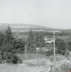
- Photograph taken from the back of 3908 Norland Avenue (originally numbered 4437 Norland Avenue), facing east. Burnaby Mountain can be seen in the background.
- Repository
- City of Burnaby Archives
- Date
- 1958 (date of original), copied 1991
- Collection/Fonds
- Burnaby Historical Society fonds
- Subseries
- Burnaby Image Bank subseries
- Physical Description
- 1 photograph : b&w ; 4.2 x 4.1 cm print on contact sheet 20.2 x 25.3 cm
- Description Level
- Item
- Record No.
- 370-029
- Access Restriction
- No restrictions
- Reproduction Restriction
- No restrictions
- Accession Number
- BHS1999-03
- Scope and Content
- Photograph taken from the back of 3908 Norland Avenue (originally numbered 4437 Norland Avenue), facing east. Burnaby Mountain can be seen in the background.
- Subjects
- Geographic Features - Mountains
- Media Type
- Photograph
- Notes
- Title based on contents of photograph
- 1 b&w copy negative accompanying
- Geographic Access
- Norland Avenue
- Burnaby Mountain Conservation Area
- Street Address
- 3908 Norland Avenue
- Historic Neighbourhood
- Burnaby Lake (Historic Neighbourhood)
- Planning Study Area
- Douglas-Gilpin Area
Images

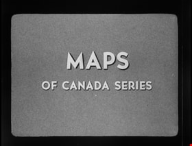
Maps of Canada Series - Forest Areas
https://search.heritageburnaby.ca/link/museumlibrary7532
- Repository
- Burnaby Village Museum
- Publication Date
- c1952
- Repository
- Burnaby Village Museum
- Collection
- Special Collection
- Material Type
- Photograph
- Accession Code
- BV016.7.6
- Place of Publication
- Ottawa
- Publisher
- National Film Board of Canada
- Publication Date
- c1952
- Physical Description
- 21 photographs : filmstrip ; cellulose aacetate, b&w pos.
- Library Subject (LOC)
- Documentary Films
- Filmstrips
- Forests and forestry--Canada
- Object History
- Came in with Oakalla Prison records and artifacts in 1991. Filmstrip was utilized by staff and inmates of Oakalla. Digitized by BVM into preservation and accessible formats in 2020.
- Notes
- Filmstrip (illustrations and text) provides a brief synopsis identifying Canada's forest regions and species in the Maritime Provinces; Quebec; Ontario; Prarie Provinces; British Columbia and Northern Areas along with the "Value of Forest Products by Province - 1948".
Images

Documents
![Margaret, Robert Leonard and Bob Love at beach in Lincoln City, [between 1950 and 1951] thumbnail](/media/hpo/_Data/_BVM_Images/2023/2023_0024_0033_001.jpg?width=280)
Margaret, Robert Leonard and Bob Love at beach in Lincoln City
https://search.heritageburnaby.ca/link/museumdescription20386
- Repository
- Burnaby Village Museum
- Date
- [between 1950 and 1951]
- Collection/Fonds
- Robert Leonard Love fonds
- Description Level
- Item
- Physical Description
- 1 photograph : b&w ; 9 x 6.5 cm
- Scope and Content
- Photograph of parents, Margaret Love and Robert Leonard Love with their son Robert Mathew "Bob" Love in the water at beach in Lincoln City, Oregon.
- Repository
- Burnaby Village Museum
- Collection/Fonds
- Robert Leonard Love fonds
- Description Level
- Item
- Physical Description
- 1 photograph : b&w ; 9 x 6.5 cm
- Scope and Content
- Photograph of parents, Margaret Love and Robert Leonard Love with their son Robert Mathew "Bob" Love in the water at beach in Lincoln City, Oregon.
- Accession Code
- BV023.24.33
- Access Restriction
- No restrictions
- Reproduction Restriction
- No known restrictions
- Date
- [between 1950 and 1951]
- Media Type
- Photograph
- Scan Resolution
- 600
- Scan Date
- 2023-12-05
- Notes
- Title based on contents of photograph
- Annotation on verso of photograph reads: "Bob-Margaret - / Bob @ Beach"
Images
![Margaret, Robert Leonard and Bob Love at beach in Lincoln City, [between 1950 and 1951] thumbnail](/media/hpo/_Data/_BVM_Images/2023/2023_0024_0033_001.jpg)

New Freeway in Burnaby
https://search.heritageburnaby.ca/link/archivedescription45383
- Repository
- City of Burnaby Archives
- Date
- 1959
- Collection/Fonds
- Columbian Newspaper collection
- Description Level
- Item
- Physical Description
- 1 photograph : b&w ; 20.5 x 18.5 cm
- Scope and Content
- Photograph of the Lower mainland's "new freeway" in Burnaby. This was taken along the Trans Canada Highway with the Willingdon exit off to the south and the Grandview Highway off to the west.
- Repository
- City of Burnaby Archives
- Date
- 1959
- Collection/Fonds
- Columbian Newspaper collection
- Physical Description
- 1 photograph : b&w ; 20.5 x 18.5 cm
- Description Level
- Item
- Record No.
- 480-278
- Access Restriction
- No restrictions
- Reproduction Restriction
- No restrictions
- Accession Number
- 2003-02
- Scope and Content
- Photograph of the Lower mainland's "new freeway" in Burnaby. This was taken along the Trans Canada Highway with the Willingdon exit off to the south and the Grandview Highway off to the west.
- Subjects
- Geographic Features - Roads
- Media Type
- Photograph
- Photographer
- King, Basil
- Notes
- Title based on note on verso of photograph
- Note on verso of photograph reads: "Lower mainland's new freeway in Burnaby"
- Geographic Access
- Trans Canada Highway
- Historic Neighbourhood
- Broadview (Historic Neighbourhood)
- Planning Study Area
- Cascade-Schou Area
Images

![New Vista Society Housing Projects, [between 1949 and 1957] thumbnail](/media/hpo/_Data/_Archives_Images/_Unrestricted/513/514-013.jpg?width=280)
New Vista Society Housing Projects
https://search.heritageburnaby.ca/link/archivedescription64687
- Repository
- City of Burnaby Archives
- Date
- [between 1949 and 1957]
- Collection/Fonds
- Ernest Winch fonds
- Description Level
- Item
- Physical Description
- 1 photograph : b&w postcard ; 8 x 13 cm
- Scope and Content
- Photographic postcard of an unpaved road lined with New Vista Society Housing Projects.
- Repository
- City of Burnaby Archives
- Date
- [between 1949 and 1957]
- Collection/Fonds
- Ernest Winch fonds
- Physical Description
- 1 photograph : b&w postcard ; 8 x 13 cm
- Description Level
- Item
- Record No.
- 514-013
- Access Restriction
- No restrictions
- Reproduction Restriction
- Reproduce for fair dealing purposes only
- Accession Number
- 2010-06
- Scope and Content
- Photographic postcard of an unpaved road lined with New Vista Society Housing Projects.
- Names
- New Vista Society
- Media Type
- Photograph
- Notes
- Title based on contents of photograph
- Handwritten in border of photograph: "1-2-3"
Images
![New Vista Society Housing Projects, [between 1949 and 1957] thumbnail](/media/hpo/_Data/_Archives_Images/_Unrestricted/513/514-013.jpg)
![Overpass, [195-] (date of original), copied 1976 thumbnail](/media/hpo/_Data/_BVM_Images/1974/197602510029.jpg?width=280)
Overpass
https://search.heritageburnaby.ca/link/museumdescription1624
- Repository
- Burnaby Village Museum
- Date
- [195-] (date of original), copied 1976
- Collection/Fonds
- Burnaby Village Museum Photograph collection
- Description Level
- Item
- Physical Description
- 1 photograph : col. negative ; 4.5 x 6.5 cm
- Scope and Content
- Photograph of a newly constructed overpass, with a roadway below prepared for construction. An unidentified man is standing on the right side. The location is unidentified, but it is likely that the photograph was taken in Burnaby.
- Repository
- Burnaby Village Museum
- Collection/Fonds
- Burnaby Village Museum Photograph collection
- Description Level
- Item
- Physical Description
- 1 photograph : col. negative ; 4.5 x 6.5 cm
- Scope and Content
- Photograph of a newly constructed overpass, with a roadway below prepared for construction. An unidentified man is standing on the right side. The location is unidentified, but it is likely that the photograph was taken in Burnaby.
- Accession Code
- HV976.251.29
- Access Restriction
- No restrictions
- Reproduction Restriction
- May be restricted by third party rights
- Date
- [195-] (date of original), copied 1976
- Media Type
- Photograph
- Scan Resolution
- 300
- Scan Date
- 22/8/2006
- Scale
- 100
- Notes
- Title based on contents of photograph
- The print is made as a black and white print from a colour negative film
Images
![Overpass, [195-] (date of original), copied 1976 thumbnail](/media/hpo/_Data/_BVM_Images/1974/197602510029.jpg)

Standard Oil Company
https://search.heritageburnaby.ca/link/archivedescription34567
- Repository
- City of Burnaby Archives
- Date
- 1958
- Collection/Fonds
- Burnaby Historical Society fonds
- Description Level
- Item
- Physical Description
- 1 photograph : b&w ; 28.0 x 35.8 cm
- Scope and Content
- Aerial photograph of the Standard Oil Company Stanovan Refinery storage and shipping area, along the Burrard Inlet.
- Repository
- City of Burnaby Archives
- Date
- 1958
- Collection/Fonds
- Burnaby Historical Society fonds
- Subseries
- Photographs subseries
- Physical Description
- 1 photograph : b&w ; 28.0 x 35.8 cm
- Description Level
- Item
- Record No.
- 052-003
- Access Restriction
- No restrictions
- Reproduction Restriction
- Reproduce for fair dealing purposes only
- Accession Number
- BHS2007-04
- Scope and Content
- Aerial photograph of the Standard Oil Company Stanovan Refinery storage and shipping area, along the Burrard Inlet.
- Media Type
- Photograph
- Notes
- Title based on contents of photograph
- Geographic Access
- Eton Street
- Street Address
- 4403 Eton Street
- Historic Neighbourhood
- Vancouver Heights (Historic Neighbourhood)
- Planning Study Area
- Burnaby Heights Area
Images

Still Creek
https://search.heritageburnaby.ca/link/archivedescription36510
- Repository
- City of Burnaby Archives
- Date
- 1950
- Collection/Fonds
- Burnaby Historical Society fonds
- Description Level
- Item
- Physical Description
- 1 photograph : b&w ; 8.5 x 14 cm
- Scope and Content
- Photograph of the Burnaby Lake bog taken from a small board walk that connected Sperling Avenue with a trail to Government Road at the west end of Burnaby Lake. Near the modern-day site of the Burnaby Lake Sports fields, this photograph was taken looking north west across Sperling Avenue and Still …
- Repository
- City of Burnaby Archives
- Date
- 1950
- Collection/Fonds
- Burnaby Historical Society fonds
- Subseries
- Photographs subseries
- Physical Description
- 1 photograph : b&w ; 8.5 x 14 cm
- Description Level
- Item
- Record No.
- 288-001
- Access Restriction
- No restrictions
- Reproduction Restriction
- Reproduce for fair dealing purposes only
- Accession Number
- BHS1992-23
- Scope and Content
- Photograph of the Burnaby Lake bog taken from a small board walk that connected Sperling Avenue with a trail to Government Road at the west end of Burnaby Lake. Near the modern-day site of the Burnaby Lake Sports fields, this photograph was taken looking north west across Sperling Avenue and Still Creek.
- Subjects
- Geographic Features - Bogs
- Names
- Still Creek
- Media Type
- Photograph
- Notes
- Title based on contents of photograph
- Photograph is a modern contact print of an original negative that was loaned to the Archives
- Geographic Access
- Still Creek
- Burnaby Lake
- Sperling Avenue
- Historic Neighbourhood
- Burnaby Lake (Historic Neighbourhood)
- Planning Study Area
- Douglas-Gilpin Area
Images

![Street clearing, [195-] (date of original), copied 1976 thumbnail](/media/hpo/_Data/_BVM_Images/1974/197602510027.jpg?width=280)
Street clearing
https://search.heritageburnaby.ca/link/museumdescription1622
- Repository
- Burnaby Village Museum
- Date
- [195-] (date of original), copied 1976
- Collection/Fonds
- Burnaby Village Museum Photograph collection
- Description Level
- Item
- Physical Description
- 1 photograph : col. negative ; 4.5 x 6.5 cm
- Scope and Content
- Photograph of the Grandview ramp off of the Trans Canada Highway in Burnaby that is cleared, possibly in preparation for the highway. The clearing for the street is several lanes wide, and in the distance, an overpass bridge can be seen. There are houses and along both sides of the cleared street.
- Repository
- Burnaby Village Museum
- Collection/Fonds
- Burnaby Village Museum Photograph collection
- Description Level
- Item
- Physical Description
- 1 photograph : col. negative ; 4.5 x 6.5 cm
- Scope and Content
- Photograph of the Grandview ramp off of the Trans Canada Highway in Burnaby that is cleared, possibly in preparation for the highway. The clearing for the street is several lanes wide, and in the distance, an overpass bridge can be seen. There are houses and along both sides of the cleared street.
- Accession Code
- HV976.251.27
- Access Restriction
- No restrictions
- Reproduction Restriction
- May be restricted by third party rights
- Date
- [195-] (date of original), copied 1976
- Media Type
- Photograph
- Scan Resolution
- 300
- Scan Date
- 22/8/2006
- Scale
- 100
- Notes
- Title based on contents of photograph
- The print is made as a black and white print from a colour negative film
Images
![Street clearing, [195-] (date of original), copied 1976 thumbnail](/media/hpo/_Data/_BVM_Images/1974/197602510027.jpg)
![Swimming at Brownie Hideaway, [between 1958 and 1960] thumbnail](/media/hpo/_Data/_BVM_Images/2015/2015_0036_0091_001.jpg?width=280)
Swimming at Brownie Hideaway
https://search.heritageburnaby.ca/link/museumdescription4548
- Repository
- Burnaby Village Museum
- Date
- [between 1958 and 1960]
- Collection/Fonds
- Burnaby Girl Guides fonds
- Description Level
- Item
- Physical Description
- 1 photograph : b&w ; 7 x 7 cm
- Scope and Content
- Photograph of a group of six unidentified people at the beach. Two women are seated on a large log at the water's edge while a group of young people are wading in the water not far from the shore.
- Repository
- Burnaby Village Museum
- Collection/Fonds
- Burnaby Girl Guides fonds
- Description Level
- Item
- Physical Description
- 1 photograph : b&w ; 7 x 7 cm
- Scope and Content
- Photograph of a group of six unidentified people at the beach. Two women are seated on a large log at the water's edge while a group of young people are wading in the water not far from the shore.
- Accession Code
- BV015.36.91
- Access Restriction
- No restrictions
- Reproduction Restriction
- May be restricted by third party rights
- Date
- [between 1958 and 1960]
- Media Type
- Photograph
- Arrangement
- Loose photographs and slides arranged by Kathryn Raadsheer nee Hardy.
- Notes
- Transcribed title
- Note in blue pencil on verso of photograph reads: "Beth_Hill"
Images
![Swimming at Brownie Hideaway, [between 1958 and 1960] thumbnail](/media/hpo/_Data/_BVM_Images/2015/2015_0036_0091_001.jpg)
![Trans Mountain Pipe Line loading dock, [1958] thumbnail](/media/Hpo/_Data/_Archives_Images/_Unrestricted/001/098-001.jpg?width=280)
Trans Mountain Pipe Line loading dock
https://search.heritageburnaby.ca/link/archivedescription34689
- Repository
- City of Burnaby Archives
- Date
- [1958]
- Collection/Fonds
- Burnaby Historical Society fonds
- Description Level
- Item
- Physical Description
- 1 photograph : b&w ; 20.4 x 25.3 cm
- Scope and Content
- Aerial photograph of the Trans Mountain Pipe Line Westridge loading dock on Burrard Inlet. Houses are visible in the background, and railroad tracks along the edge of the inlet.
- Repository
- City of Burnaby Archives
- Date
- [1958]
- Collection/Fonds
- Burnaby Historical Society fonds
- Subseries
- Photographs subseries
- Physical Description
- 1 photograph : b&w ; 20.4 x 25.3 cm
- Description Level
- Item
- Record No.
- 098-001
- Access Restriction
- No restrictions
- Reproduction Restriction
- Reproduce for fair dealing purposes only
- Accession Number
- BHS2007-04
- Scope and Content
- Aerial photograph of the Trans Mountain Pipe Line Westridge loading dock on Burrard Inlet. Houses are visible in the background, and railroad tracks along the edge of the inlet.
- Media Type
- Photograph
- Photographer
- Commercial Illustrators Industrial Photographers
- Notes
- Title based on contents of photograph
- Stamp and annotation on back of photograph reads, "TA. 8817 / Commerical Illustrators / Industrial Photographers / 601 Denman St., Vancouver 5, B.C. / File No. 9412-2"
- Historic Neighbourhood
- Lochdale (Historic Neighbourhood)
- Planning Study Area
- Westridge Area
Images
![Trans Mountain Pipe Line loading dock, [1958] thumbnail](/media/Hpo/_Data/_Archives_Images/_Unrestricted/001/098-001.jpg)
![Two lane tunnel, [between 1947 and 1957] thumbnail](/media/hpo/_Data/_BVM_Images/2022/2022_0032_0569_001.jpg?width=280)
Two lane tunnel
https://search.heritageburnaby.ca/link/museumdescription20147
- Repository
- Burnaby Village Museum
- Date
- [between 1947 and 1957]
- Collection/Fonds
- Esther Love Stanley fonds
- Description Level
- Item
- Physical Description
- 1 photograph : b&w ; 6 x 9 cm
- Scope and Content
- Photograph of a two lane tunnel on an unidentified roadway. A garden with flowers is between the two tunnel openings.
- Repository
- Burnaby Village Museum
- Collection/Fonds
- Esther Love Stanley fonds
- Description Level
- Item
- Physical Description
- 1 photograph : b&w ; 6 x 9 cm
- Scope and Content
- Photograph of a two lane tunnel on an unidentified roadway. A garden with flowers is between the two tunnel openings.
- Subjects
- Structures
- Geographic Features - Roads
- Accession Code
- BV022.32.569
- Access Restriction
- No restrictions
- Reproduction Restriction
- No known restrictions
- Date
- [between 1947 and 1957]
- Media Type
- Photograph
- Scan Resolution
- 600
- Scan Date
- 2023-09-04
- Notes
- Title based on contents of photograph
- Photograph is part of Esther Love Stanley photograph album 2 (BV032.22.431)
Images
![Two lane tunnel, [between 1947 and 1957] thumbnail](/media/hpo/_Data/_BVM_Images/2022/2022_0032_0569_001.jpg)
![Valerie and Dorothy Shantz, [1956] (date of original), copied 1991 thumbnail](/media/hpo/_Data/_Archives_Images/_Unrestricted/370/370-178.jpg?width=280)
Valerie and Dorothy Shantz
https://search.heritageburnaby.ca/link/archivedescription37590
- Repository
- City of Burnaby Archives
- Date
- [1956] (date of original), copied 1991
- Collection/Fonds
- Burnaby Historical Society fonds
- Description Level
- Item
- Physical Description
- 1 photograph : b&w ; 4.6 x 3.1 cm print on contact sheet 20.2 x 25.3 cm
- Scope and Content
- Photograph of Dorothy Shantz holding her daughter, Valerie Shantz. The photograph was taken looking east along Albert Street at Madison Avenue. Capitol Hill is visible in the background.
- Repository
- City of Burnaby Archives
- Date
- [1956] (date of original), copied 1991
- Collection/Fonds
- Burnaby Historical Society fonds
- Subseries
- Burnaby Image Bank subseries
- Physical Description
- 1 photograph : b&w ; 4.6 x 3.1 cm print on contact sheet 20.2 x 25.3 cm
- Description Level
- Item
- Record No.
- 370-178
- Access Restriction
- No restrictions
- Reproduction Restriction
- No restrictions
- Accession Number
- BHS1999-03
- Scope and Content
- Photograph of Dorothy Shantz holding her daughter, Valerie Shantz. The photograph was taken looking east along Albert Street at Madison Avenue. Capitol Hill is visible in the background.
- Subjects
- Geographic Features - Roads
- Media Type
- Photograph
- Notes
- Title based on contents of photograph
- 2 b&w copy prints accompanying
- 1 b&w copy negative accompanying
- Negative has a pink cast
- Geographic Access
- Albert Street
- Madison Avenue
- Historic Neighbourhood
- Vancouver Heights (Historic Neighbourhood)
- Planning Study Area
- Burnaby Heights Area
Images
![Valerie and Dorothy Shantz, [1956] (date of original), copied 1991 thumbnail](/media/hpo/_Data/_Archives_Images/_Unrestricted/370/370-178.jpg)
![Walking to June Ickringills house, [1957 or 1958] thumbnail](/media/hpo/_Data/_Archives_Images/_Unrestricted/205/246-011.jpg?width=280)
Walking to June Ickringills house
https://search.heritageburnaby.ca/link/archivedescription52971
- Repository
- City of Burnaby Archives
- Date
- [1957 or 1958]
- Collection/Fonds
- Burnaby Historical Society fonds
- Description Level
- Item
- Physical Description
- 1 photograph : b&w ; 7 x 10 cm, mounted on heavy-weight paper 17.5 x 27.5 cm
- Scope and Content
- Photograph of four kindergartners walking along a gravel sidewalk, along a gravel road to June Ickringills house. The girl in front is wearing a plaid dress, and the three boys behind her are wearing short pants and short-sleeve dress shirts. There is a woman in a white dress walking on the other s…
- Repository
- City of Burnaby Archives
- Date
- [1957 or 1958]
- Collection/Fonds
- Burnaby Historical Society fonds
- Subseries
- Tinkerbell Kindergarten subseries
- Physical Description
- 1 photograph : b&w ; 7 x 10 cm, mounted on heavy-weight paper 17.5 x 27.5 cm
- Description Level
- Item
- Record No.
- 246-011
- Access Restriction
- No restrictions
- Reproduction Restriction
- Reproduce for fair dealing purposes only
- Accession Number
- BHS1990-12
- Scope and Content
- Photograph of four kindergartners walking along a gravel sidewalk, along a gravel road to June Ickringills house. The girl in front is wearing a plaid dress, and the three boys behind her are wearing short pants and short-sleeve dress shirts. There is a woman in a white dress walking on the other side of the street, in front of a house with a white picket fence.
- Media Type
- Photograph
- Notes
- Title based on contents of photograph
- Handwritten note on paper mount reads: "Visit to June Ickringill's Home 1957-1958"
Images
![Walking to June Ickringills house, [1957 or 1958] thumbnail](/media/hpo/_Data/_Archives_Images/_Unrestricted/205/246-011.jpg)
![Westlawn Drive, [1953] thumbnail](/media/hpo/_Data/_Archives_Images/_Unrestricted/371/401-001.jpg?width=280)
Westlawn Drive
https://search.heritageburnaby.ca/link/archivedescription38304
- Repository
- City of Burnaby Archives
- Date
- [1953]
- Collection/Fonds
- Burnaby Historical Society fonds
- Description Level
- Item
- Physical Description
- 1 photograph : b&w ; 20.3 x 24.8 cm
- Scope and Content
- Photograph of Westlawn Drive, in the Brentwood area, under construction. A number of houses can be seen in various stages of construction and the road is unpaved.
- Repository
- City of Burnaby Archives
- Date
- [1953]
- Collection/Fonds
- Burnaby Historical Society fonds
- Subseries
- Jim Wolf subseries
- Physical Description
- 1 photograph : b&w ; 20.3 x 24.8 cm
- Description Level
- Item
- Record No.
- 401-001
- Access Restriction
- No restrictions
- Reproduction Restriction
- Reproduce for fair dealing purposes only
- Accession Number
- BHS2000-11
- Scope and Content
- Photograph of Westlawn Drive, in the Brentwood area, under construction. A number of houses can be seen in various stages of construction and the road is unpaved.
- Subjects
- Construction
- Geographic Features - Roads
- Media Type
- Photograph
- Notes
- Title based on contents of photograph.
- Geographic Access
- Westlawn Drive
- Planning Study Area
- Brentwood Area
Images
![Westlawn Drive, [1953] thumbnail](/media/hpo/_Data/_Archives_Images/_Unrestricted/371/401-001.jpg)
![Adell Philips and daughter holding rabbits, [1956] thumbnail](/media/hpo/_Data/_BVM_Images/2022/2022_0011_0021_001.jpg?width=280)
Adell Philips and daughter holding rabbits
https://search.heritageburnaby.ca/link/museumdescription19103
- Repository
- Burnaby Village Museum
- Date
- [1956]
- Collection/Fonds
- Earl and Adell Philips family fonds
- Description Level
- Item
- Physical Description
- 1 photograph : b&w ; 11.5 x 7 cm
- Scope and Content
- Photograph of Adell Philips holding a white rabbit and standing outside in a yard beside one of her children (could be her daughter Judith Philips) who is also holding a white rabbit. There is a black and white cat sitting on the fence behind them and a corner of a house is visible in the backgroun…
- Repository
- Burnaby Village Museum
- Collection/Fonds
- Earl and Adell Philips family fonds
- Description Level
- Item
- Physical Description
- 1 photograph : b&w ; 11.5 x 7 cm
- Scope and Content
- Photograph of Adell Philips holding a white rabbit and standing outside in a yard beside one of her children (could be her daughter Judith Philips) who is also holding a white rabbit. There is a black and white cat sitting on the fence behind them and a corner of a house is visible in the background.
- Subjects
- Animals
- Animals - Cats
- Accession Code
- BV022.11.21
- Access Restriction
- No restrictions
- Reproduction Restriction
- No known restrictions
- Date
- [1956]
- Media Type
- Photograph
- Notes
- Title based on contents of photograph
- Note in blue ink on verso of photograph reads: “Dell & baby [sic] / Spring 1956”
- Stamp on verso of photograph reads: “103” [sic]
Images
![Adell Philips and daughter holding rabbits, [1956] thumbnail](/media/hpo/_Data/_BVM_Images/2022/2022_0011_0021_001.jpg)
![Digney family in Burnaby, [between 1939 and 1959] thumbnail](/media/Hpo/_Data/_Archives_Moving_Images/_Unrestricted/562-003-12.jpg?width=280)
Digney family in Burnaby
https://search.heritageburnaby.ca/link/archivedescription85249
- Repository
- City of Burnaby Archives
- Date
- [between 1939 and 1959]
- Collection/Fonds
- Digney Family fonds
- Description Level
- Item
- Physical Description
- 1 film clip (5 min., 17sec.) : digital, col., si.
- Scope and Content
- Item is a digitized film colour segment identified as Reel 12. The film is a compilation of Digney family events. The film opens with children Paul and Bruce Digney running around the Digney family yard at their home on Bonsor Avenue with Andy and Ernest (Dig) Digney looking on. This is followed by…
- Repository
- City of Burnaby Archives
- Date
- [between 1939 and 1959]
- Collection/Fonds
- Digney Family fonds
- Physical Description
- 1 film clip (5 min., 17sec.) : digital, col., si.
- Description Level
- Item
- Record No.
- 562-003-12
- Access Restriction
- No restrictions
- Reproduction Restriction
- May be restricted by third party rights
- Accession Number
- 2014-04
- Scope and Content
- Item is a digitized film colour segment identified as Reel 12. The film is a compilation of Digney family events. The film opens with children Paul and Bruce Digney running around the Digney family yard at their home on Bonsor Avenue with Andy and Ernest (Dig) Digney looking on. This is followed by interspersed footage of the family's pet dog Nero and puppies along with some brief glimpses of the Royal visit (King George VI and Queen Elizabeth) and cavilicade in 1939 along Kingsway. The film then switches to footage of Digney family Christmas festivities, a cat playing with a fish in a bowl and summer time at Pelican Lake in the 1940s and ends with a dog playing with a ball.
- Media Type
- Moving Images
- Photographer
- Digney, Andy
- Creator
- Digney, Andy
- Notes
- Title based on contents of film
- Geographic Access
- Bonsor Avenue
- Kingsway
- Historic Neighbourhood
- Central Park (Historic Neighbourhood)
- Planning Study Area
- Maywood Area
Images
![Digney family in Burnaby, [between 1939 and 1959] thumbnail](/media/Hpo/_Data/_Archives_Moving_Images/_Unrestricted/562-003-12.jpg)
Video
Digney family in Burnaby, [between 1939 and 1959]
Digney family in Burnaby, [between 1939 and 1959]
https://search.heritageburnaby.ca/media/hpo/_Data/_Archives_Moving_Images/_Unrestricted/562-003-12.m4vInterview with Maureen Olofson by Kathy Bossort October 14, 2015 - Track 3
https://search.heritageburnaby.ca/link/oralhistory571
- Repository
- City of Burnaby Archives
- Date Range
- 1942-1980
- Length
- 0:06:55
- Summary
- This portion of the interview is about Maureen Olofson’s description of the food sources on the farm including the garden, food animals, berry picking and bears. She also describes what her parents did after giving up the farm, opening sporting good stores on Hastings Street and then in North Vanco…
- Repository
- City of Burnaby Archives
- Summary
- This portion of the interview is about Maureen Olofson’s description of the food sources on the farm including the garden, food animals, berry picking and bears. She also describes what her parents did after giving up the farm, opening sporting good stores on Hastings Street and then in North Vancouver.
- Date Range
- 1942-1980
- Length
- 0:06:55
- Names
- Olofson, Axel
- GAK Fur Farm
- Geographic Access
- Burnaby Mountain Conservation Area
- Historic Neighbourhood
- Lochdale (Historic Neighbourhood)
- Planning Study Area
- Westridge Area
- Lochdale Area
- Interviewer
- Bossort, Kathy
- Interview Date
- October 14, 2015
- Scope and Content
- Recording is of an interview with Maureen Olofson conducted by Kathy Bossort. Maureen Olofson was one of 23 participants interviewed as part of the Community Heritage Commission’s Burnaby Mountain Oral History Project. The interview is mainly about Maureen Olofson’s memories of growing up on her parent’s Burnaby Mountain mink ranch between 1942 and 1950 and about the operation of the farm. She also talks about her parents’ history, her teaching career, and her thoughts about the beauty and value of Burnaby Mountain’s natural area.
- Biographical Notes
- Maureen Olofson was born 1938 in Glote, Harjedalen, Sweden, to Axel (1906-1998) and Kerstin Margareta (1906-1980). Axel and Kerstin Olofson, who had separately immigrated to Canada in 1928 and 1913 respectively, married in Canada and then returned to Sweden where Maureen was born. They moved to Burnaby in 1942 with their daughters Maureen and Anita Lea, and bought land and a mink ranch on Burnaby Mountain with their partners Gus Skofteby and Karin Ericksson (Kerstin’s sister). The GAK Fur Farm, located in the old Hastings Grove subdivision on 4th Avenue near Curtis Street, was one of the largest mink ranches in BC, an award winning operation with over 1200 mink animals. In 1950 the partners sold the land and the Olofson family moved to rented homes on Sperling Avenue. In 1952 Axel sold the last of his minks and opened a sporting goods store on Hastings Street. In 1954 the family moved to North Vancouver where Axel Olofson reestablished his sports business. Maureen attended Sperling Avenue School from Gr. 1 to Gr. 8 and Burnaby North High School to Gr. 11, completing school in North Vancouver, before going to UBC where she trained as a teacher. She returned to Burnaby in 1977 to teach, retiring in 1997. She is a volunteer with the Swedish Canadian Rest Home Association and the Dania Homes Society. Maureen continues to enjoy activities on Burnaby Mountain and works toward preserving the natural beauty of the mountain.
- Total Tracks
- 8
- Total Length
- 1:19:04
- Interviewee Name
- Olofson, B. Maureen
- Interview Location
- Maureen Olofson's home in Burnaby
- Interviewer Bio
- Kathy Bossort is a retired archivist living in Ladner, BC. She worked at the Delta Museum and Archives after graduating from SLAIS (UBC) in 2001 with Masters degrees in library science and archival studies. Kathy grew up in Calgary, Alberta, and, prior to this career change, she lived in the West Kootenays, earning her living as a cook for BC tourist lodges and work camps. She continues to be interested in oral histories as a way to fill the gaps in the written record and bring richer meaning to history.
- Collection/Fonds
- Community Heritage Commission Special Projects fonds
- Media Type
- Sound Recording
Audio Tracks
Track three of interview with Maureen Olofson
Track three of interview with Maureen Olofson
https://search.heritageburnaby.ca/media/hpo/_Data/_Archives_Oral_Histories/_Unrestricted/MSS196-004/MSS196-004_Track_3.mp3