Narrow Results By
Subject
- Aerial Photographs 1
- Animals - Fish 1
- Arts 1
- Arts - Paintings 1
- Buildings - Industrial - Mills 2
- Buildings - Industrial - Saw Mills 1
- Buildings - Residential 2
- Buildings - Schools - Universities and Colleges 1
- Geographic Features - Inlets 2
- Geographic Features - Lakes and Ponds 1
- Geographic Features - Parks 2
- Geographic Features - Rivers 1

North Burnaby Cenotaph
https://search.heritageburnaby.ca/link/landmark550
- Repository
- Burnaby Heritage Planning
- Description
- The North Burnaby Cenotaph is located in Confederation Park at the north end of the park on axis with the adjacent sports oval. The form of the memorial is of an obelisk atop a solid rectangular base, adorned with plaques commemorating those lost in the First World War, Second World War and the Kor…
- Associated Dates
- 1953
- Formal Recognition
- Heritage Designation, Community Heritage Register
- Repository
- Burnaby Heritage Planning
- Geographic Access
- Willingdon Avenue
- Associated Dates
- 1953
- Formal Recognition
- Heritage Designation, Community Heritage Register
- Enactment Type
- Bylaw No. 9807
- Enactment Date
- 23/11/1992
- Description
- The North Burnaby Cenotaph is located in Confederation Park at the north end of the park on axis with the adjacent sports oval. The form of the memorial is of an obelisk atop a solid rectangular base, adorned with plaques commemorating those lost in the First World War, Second World War and the Korean War.
- Heritage Value
- Built in 1953 by stonemason and First World War Veteran, Walter Holmes Morrice, the cenotaph was erected by the North Burnaby Legion Post #148 and is one of four memorials to citizens of Burnaby whose lives were lost at war. Strategically placed in an active and vibrant public park that was dedicated in 1927 and is used for sports, family outings and social gatherings, the cenotaph celebrates the freedoms that soldiers gave their lives to protect. The cenotaph is still used as a memorial site and bears witness to annual Remembrance Day ceremonies. Built of irregular granite blocks, the cenotaph is a solid structure of modest ornamentation that visually anchors the north end of the park. The site of the cenotaph and its adjacent gardens are surrounded by a simple barrier of continuous chain supported by low metal fence posts, providing a sense of solemnity and ceremony to the site.
- Defining Elements
- The character-defining elements of the North Burnaby Cenotaph include its: - axial location in the park and setting among active municipal facilities such as a school and library - strong symmetry of massing and design - obelisk form set atop a rectangular base - limited palette of materials - random coursed granite used as primary building material - bronze plaques commemorating the First and Second World Wars and the Korean War - surrounding pathways and flowerbeds
- Historic Neighbourhood
- Capitol Hill (Historic Neighbourhood)
- Planning Study Area
- Capitol Hill Area
- Organization
- North Burnaby Legion Post #148
- Builder
- Walter Holmes Morrice
- Function
- Primary Current--Park Fixture
- Primary Historic--Park Fixture
- Community
- Burnaby
- Cadastral Identifier
- P.I.D. No. 017-040-752 Legal Description: Parcel 1, District Lots 122 and 188, Group 1, New Westminster District, Plan NWP87902
- Boundaries
- The property (Confederation Park) is comprised of a single municipally-owned property located at 250 Willingdon Avenue, Burnaby.
- Area
- 184,160.00
- Contributing Resource
- Landscape Feature
- Structure
- Ownership
- Public (local)
- Documentation
- Heritage Site Files: PC77000 20. City of Burnaby Planning and Building Department, 4949 Canada Way, Burnaby, B.C., V5G 1M2
- Street Address
- 250 Willingdon Avenue
Images


Aubrey Elementary School
https://search.heritageburnaby.ca/link/landmark785
- Repository
- Burnaby Heritage Planning
- Geographic Access
- Stratford Avenue
- Associated Dates
- 1959
- Heritage Value
- Aubrey Avenue School was built in 1959 to help alleviate the increased enrolment at other North Burnaby schools due to the development of new subdivisions such as Brentwood, Capitol Hill and Westridge. Additions to the original structure were made in 1962, 1963, 1964, 1967 and 1972.
- Planning Study Area
- Parkcrest-Aubrey Area
- Street Address
- 1075 Stratford Avenue
- Street View URL
- Google Maps Street View
Images


Brentwood Park Elementary School
https://search.heritageburnaby.ca/link/landmark679
- Repository
- Burnaby Heritage Planning
- Geographic Access
- Delta Avenue
- Associated Dates
- 1954
- Heritage Value
- Brentwood Park Elementary School was built during the post-World War Two housing boom in Burnaby and like other schools at the time, was similar in design - no basements, no second stories and no high stairways. New classrooms could be added in line with the original structure as was the case when two additions were put on between 1956 and 1958, a new classroom and library added in 1965-1966 and two more classrooms in 1969.
- Planning Study Area
- Brentwood Area
- Street Address
- 1455 Delta Avenue
- Street View URL
- Google Maps Street View
Images


Burnaby Municipal Hall
https://search.heritageburnaby.ca/link/landmark807
- Repository
- Burnaby Heritage Planning
- Geographic Access
- Canada Way
- Associated Dates
- 1956
- Heritage Value
- When staff outgrew the municipal buildings at Edmonds and Kingsway, a debate erupted over where to build a new municipal hall. North Burnaby residents argued against the Kingsway and Edmonds site as it was too removed for their needs, but South Burnaby residents were not prepared to accept a hall in North Burnaby. The debate was finally resolved when it was suggested that the new civic centre for the municipality be in the exact geographic centre of Burnaby. Fortunately, this meant that the new hall was to be built near Deer Lake, in the beautiful Central Valley setting. Burnaby voters accepted this decision and approved the $625,000.00 it would take to build the new structure and the official opening ceremony was held June 22, 1956 when then Reeve Charles MacSorley received the keys to the hall from the contractor.
- Historic Neighbourhood
- Burnaby Lake (Historic Neighbourhood)
- Planning Study Area
- Douglas-Gilpin Area
- Street Address
- 4949 Canada Way
- Street View URL
- Google Maps Street View
Images


Suncrest School
https://search.heritageburnaby.ca/link/landmark694
- Repository
- Burnaby Heritage Planning
- Geographic Access
- Rumble Street
- Associated Dates
- 1953
- Heritage Value
- The new Suncrest subdivision developed in the early 1950s, resulting in 312 new homes in 1951, with an additional 100 being planned. As a result, enrolment pressure resulted in the construction of Suncrest School in 1953. Additions to the original structure were made in 1954 and a library, change rooms and staffroom were added in 1969.
- Historic Neighbourhood
- Alta Vista (Historic Neighbourhood)
- Planning Study Area
- Suncrest Area
- Street Address
- 3883 Rumble Street
- Street View URL
- Google Maps Street View
Images

![Bird watchers at Piper Pier, [2004] thumbnail](/media/hpo/_Data/_Archives_Images/_Unrestricted/535/535-1757.jpg?width=280)
Bird watchers at Piper Pier
https://search.heritageburnaby.ca/link/archivedescription96006
- Repository
- City of Burnaby Archives
- Date
- [2004]
- Collection/Fonds
- Burnaby NewsLeader photograph collection
- Description Level
- Item
- Physical Description
- 1 photograph (tiff) : col.
- Scope and Content
- Photograph of two bird watchers standing on Piper Pier in Burnaby Lake Regional Park. They are both looking into the distance with binoculars.
- Repository
- City of Burnaby Archives
- Date
- [2004]
- Collection/Fonds
- Burnaby NewsLeader photograph collection
- Physical Description
- 1 photograph (tiff) : col.
- Description Level
- Item
- Record No.
- 535-1757
- Access Restriction
- No restrictions
- Reproduction Restriction
- No restrictions
- Accession Number
- 2018-12
- Scope and Content
- Photograph of two bird watchers standing on Piper Pier in Burnaby Lake Regional Park. They are both looking into the distance with binoculars.
- Media Type
- Photograph
- Photographer
- Bartel, Mario
- Notes
- Title based on caption
- Collected by editorial for use in a January 2004 issue of the Burnaby NewsLeader
- Caption from metadata: "Juliet and Martin Mohlmann say they come down to Piper Pier at Burnaby Lake Regional Park to watch birds about twice a month. But they won't be able to use the pier in the late summer, as the GVRD, the Burnaby Rotary Club and Terasen will be spending $115,000 to rebuild it."
- Geographic Access
- Burnaby Lake Regional Nature Park
- Burnaby Lake
- Historic Neighbourhood
- Burnaby Lake (Historic Neighbourhood)
- Planning Study Area
- Burnaby Lake Area
Images
![Bird watchers at Piper Pier, [2004] thumbnail](/media/hpo/_Data/_Archives_Images/_Unrestricted/535/535-1757.jpg)
![Cariboo Dam fish weir, [2002] thumbnail](/media/hpo/_Data/_Archives_Images/_Unrestricted/535/535-2996.jpg?width=280)
Cariboo Dam fish weir
https://search.heritageburnaby.ca/link/archivedescription97722
- Repository
- City of Burnaby Archives
- Date
- [2002]
- Collection/Fonds
- Burnaby NewsLeader photograph collection
- Description Level
- Item
- Physical Description
- 1 photograph (tiff) : col.
- Scope and Content
- Photograph of Elmer Rudolph and Bob Henderson helping a salmon through the fish weir at the Cariboo Dam on the Brunette River.
- Repository
- City of Burnaby Archives
- Date
- [2002]
- Collection/Fonds
- Burnaby NewsLeader photograph collection
- Physical Description
- 1 photograph (tiff) : col.
- Description Level
- Item
- Record No.
- 535-2996
- Access Restriction
- No restrictions
- Reproduction Restriction
- No restrictions
- Accession Number
- 2018-12
- Scope and Content
- Photograph of Elmer Rudolph and Bob Henderson helping a salmon through the fish weir at the Cariboo Dam on the Brunette River.
- Media Type
- Photograph
- Photographer
- Bartel, Mario
- Notes
- Title based on caption
- Collected by editorial for use in a November 2002 issue of the Burnaby NewsLeader
- Caption from metadata: "Elmer Rudolph and Bob Henderson help a mature female salmon, weighing about nine pounds, up through the fish weir at the Cariboo dam. The week of heavy rain has finally made conditions favorable for fish to make their journey up the Brunette River from the Fraser, and then on to their spawning beds, and Rudolph is at the dam every day to help them along. On Saturday, in addition to the mature salmon, he also helped four immature males and two 14-inch Cutthroat."
- Geographic Access
- Burnaby Lake
- Brunette River
- Historic Neighbourhood
- Burnaby Lake (Historic Neighbourhood)
- Planning Study Area
- Burnaby Lake Area
Images
![Cariboo Dam fish weir, [2002] thumbnail](/media/hpo/_Data/_Archives_Images/_Unrestricted/535/535-2996.jpg)

Collapse of Second Narrows Bridge
https://search.heritageburnaby.ca/link/archivedescription37290
- Repository
- City of Burnaby Archives
- Date
- 1958
- Collection/Fonds
- Burnaby Historical Society fonds
- Description Level
- Item
- Physical Description
- 1 photograph : b&w ; 9.5 x 9.5 cm
- Scope and Content
- Photograph shows a picture of the Second Narrows Bridge in Vancouver, BC after its collapse in 1958.
- Repository
- City of Burnaby Archives
- Date
- 1958
- Collection/Fonds
- Burnaby Historical Society fonds
- Subseries
- Norah Code subseries
- Physical Description
- 1 photograph : b&w ; 9.5 x 9.5 cm
- Description Level
- Item
- Record No.
- 345-011
- Access Restriction
- No restrictions
- Reproduction Restriction
- Reproduce for fair dealing purposes only
- Accession Number
- BHS1997-05
- Scope and Content
- Photograph shows a picture of the Second Narrows Bridge in Vancouver, BC after its collapse in 1958.
- Subjects
- Structures - Bridges
- Media Type
- Photograph
- Notes
- Title based on contents of photograph.
- Photographs in this collection were taken and compiled by Norah Code, former editor of the "Burnaby Courier" newspaper during the course of her work for the newspaper.
Images

![Gaglardi Way pedestrian overpass, [2005] thumbnail](/media/hpo/_Data/_Archives_Images/_Unrestricted/535/535-1858.jpg?width=280)
Gaglardi Way pedestrian overpass
https://search.heritageburnaby.ca/link/archivedescription96161
- Repository
- City of Burnaby Archives
- Date
- [2005]
- Collection/Fonds
- Burnaby NewsLeader photograph collection
- Description Level
- Item
- Physical Description
- 1 photograph (tiff) : col.
- Scope and Content
- Photograph of Alex Nemeth posing next to his truck and the pedestrian overpass on Gaglardi Way.
- Repository
- City of Burnaby Archives
- Date
- [2005]
- Collection/Fonds
- Burnaby NewsLeader photograph collection
- Physical Description
- 1 photograph (tiff) : col.
- Description Level
- Item
- Record No.
- 535-1858
- Access Restriction
- No restrictions
- Reproduction Restriction
- No restrictions
- Accession Number
- 2018-12
- Scope and Content
- Photograph of Alex Nemeth posing next to his truck and the pedestrian overpass on Gaglardi Way.
- Media Type
- Photograph
- Photographer
- Bartel, Mario
- Notes
- Title based on caption
- Collected by editorial for use in a January 2005 issue of the Burnaby NewsLeader
- Caption from metadata: "The windshield on Alex Nemeth's pickup truck was smashed on Tuesday when kids dropped snowballs filled with rocks from the pedestrian overpass on Gagliardi Way in Burnaby as he passed underneath on his way to work. The City of Burnaby has promised to enclose the walkway."
- Geographic Access
- Gaglardi Way
Images
![Gaglardi Way pedestrian overpass, [2005] thumbnail](/media/hpo/_Data/_Archives_Images/_Unrestricted/535/535-1858.jpg)
![Grand Coulee Dam under construction, [between 1947 and 1957] thumbnail](/media/hpo/_Data/_BVM_Images/2022/2022_0032_0556_001.jpg?width=280)
Grand Coulee Dam under construction
https://search.heritageburnaby.ca/link/museumdescription20134
- Repository
- Burnaby Village Museum
- Date
- [between 1947 and 1957]
- Collection/Fonds
- Esther Love Stanley fonds
- Description Level
- Item
- Physical Description
- 1 photograph : b&w ; 9 x 14 cm
- Scope and Content
- Photograph of Grand Coulee Dam under construction. Water is gushing through the lower section of the dam. The dam was completed in 1942.
- Repository
- Burnaby Village Museum
- Collection/Fonds
- Esther Love Stanley fonds
- Description Level
- Item
- Physical Description
- 1 photograph : b&w ; 9 x 14 cm
- Scope and Content
- Photograph of Grand Coulee Dam under construction. Water is gushing through the lower section of the dam. The dam was completed in 1942.
- Subjects
- Structures - Dams
- Accession Code
- BV022.32.556
- Access Restriction
- No restrictions
- Reproduction Restriction
- No known restrictions
- Date
- [between 1947 and 1957]
- Media Type
- Photograph
- Scan Resolution
- 600
- Scan Date
- 2023-08-22
- Notes
- Title based on contents of photograph
- Photograph is part of Esther Love Stanley photograph album 2 (BV032.22.431)
- Note in white ink on album page reads: "GRAND COULEE DAM / 1936"
Images
![Grand Coulee Dam under construction, [between 1947 and 1957] thumbnail](/media/hpo/_Data/_BVM_Images/2022/2022_0032_0556_001.jpg)

Interview with Judy Hagen by Eric Damer November 7, 2012 - Track 6
https://search.heritageburnaby.ca/link/oralhistory337
- Repository
- City of Burnaby Archives
- Date Range
- 1944-2012
- Length
- 0:12:18
- Summary
- This portion of the recording pertains to Judith "Judy" (Robins) Hagen's memories of taking dance lessons and being in Girl Guides. She tells a story of seeing the Second Narrows Bridge collapse in 1958.
- Repository
- City of Burnaby Archives
- Summary
- This portion of the recording pertains to Judith "Judy" (Robins) Hagen's memories of taking dance lessons and being in Girl Guides. She tells a story of seeing the Second Narrows Bridge collapse in 1958.
- Date Range
- 1944-2012
- Photo Info
- Judith "Judy" Robins (later Hagen) posing in a dance costume, 1949. Item no. 549-036.
- Length
- 0:12:18
- Interviewer
- Damer, Eric
- Interview Date
- November 7, 2012
- Scope and Content
- Recording is an interview with Judith "Judy" (Robins) Hagen conducted by Burnaby Village Museum employee Eric Damer, November 7, 2012. Major theme discussed: the neighbourhood of Dover Street.
- Biographical Notes
- Judy Robins (later Hagen) was born in 1941 and grew up in South Burnaby. Her paternal grandfather, a master stone mason from Devon, moved to Vancouver in 1912 to find work before bringing over the rest of the family. He bought three lots in Burnaby and in 1918 moved his family to a small house on Dover Street (formerly Paul Street). Judy’s father, Jack, married, bought one of his father’s lots and built a new home for his family. Judy attended school and church nearby, took dance and piano lessons and participated actively in Girl Guides. After high school, she attended the University of British Columbia (UBC) and then Simon Fraser University (SFU), worked for a few years and then married in 1967 before moving to Courtaney, British Columbia.
- Total Tracks
- 7
- Total Length
- 1:09:51
- Interviewee Name
- Hagen, Judith "Judy" Robins
- Interview Location
- Nanaimo Museum on Vancouver Island
- Interviewer Bio
- Eric Damer is a lifelong British Columbian born in Victoria, raised in Kamloops, and currently residing in Burnaby. After studying philosophy at the University of Victoria, he became interested in the educational forces that had shaped his own life. He completed master’s and doctoral degrees in educational studies at the University of British Columbia with a particular interest in the history of adult and higher education in the province. In 2012, Eric worked for the City of Burnaby as a field researcher and writer, conducting interviews for the City Archives and Museum Oral History Program.
- Collection/Fonds
- Community Heritage Commission Special Projects fonds
- Transcript Available
- None
- Media Type
- Sound Recording
Images

Audio Tracks
Track six of recording of interview with Judy Hagen
Track six of recording of interview with Judy Hagen
https://search.heritageburnaby.ca/media/hpo/_Data/_Archives_Oral_Histories/_Unrestricted/MSS171-011/MSS171-011_Track_6.mp3![Peter Beynon on Rotary Walkway at Burnaby Lake, [2005] thumbnail](/media/hpo/_Data/_Archives_Images/_Unrestricted/535/535-1936.jpg?width=280)
Peter Beynon on Rotary Walkway at Burnaby Lake
https://search.heritageburnaby.ca/link/archivedescription96253
- Repository
- City of Burnaby Archives
- Date
- [2005]
- Collection/Fonds
- Burnaby NewsLeader photograph collection
- Description Level
- Item
- Physical Description
- 1 photograph (tiff) : col.
- Scope and Content
- Photograph of Peter Beynon, president of the Rotary Club of Burnaby, on the Rotary Walkway at Piper Spit on Burnaby Lake. The walkway extends behind him and the viewing deck at the end, Burnaby Lake, and the trees surrounding the lake are visible in the background.
- Repository
- City of Burnaby Archives
- Date
- [2005]
- Collection/Fonds
- Burnaby NewsLeader photograph collection
- Physical Description
- 1 photograph (tiff) : col.
- Description Level
- Item
- Record No.
- 535-1936
- Access Restriction
- No restrictions
- Reproduction Restriction
- No restrictions
- Accession Number
- 2018-12
- Scope and Content
- Photograph of Peter Beynon, president of the Rotary Club of Burnaby, on the Rotary Walkway at Piper Spit on Burnaby Lake. The walkway extends behind him and the viewing deck at the end, Burnaby Lake, and the trees surrounding the lake are visible in the background.
- Subjects
- Geographic Features - Lakes and Ponds
- Geographic Features - Parks
- Structures - Piers and Wharfs
- Media Type
- Photograph
- Photographer
- Medig, Kari
- Notes
- Title based on caption
- Collected by editorial for use in a February 2005 issue of the Burnaby NewsLeader
- Caption from metadata: "Rotary Club of Burnaby president Peter Beynon stands on the new Rotary Walkway at Piper Spit on Burnaby Lake on Wednesday afternoon. The new walkway, a joint venture of local Rotary Clubs, the GVRD, the Pacific Parklands Foundation and Terasen, will be officially unveiled February 23."
- Geographic Access
- Burnaby Lake
- Burnaby Lake Regional Nature Park
- Historic Neighbourhood
- Burnaby Lake (Historic Neighbourhood)
- Planning Study Area
- Burnaby Lake Area
Images
![Peter Beynon on Rotary Walkway at Burnaby Lake, [2005] thumbnail](/media/hpo/_Data/_Archives_Images/_Unrestricted/535/535-1936.jpg)
![Rob Third and steel pedestrian overpass, [2006] thumbnail](/media/hpo/_Data/_Archives_Images/_Unrestricted/535/535-1902.jpg?width=280)
Rob Third and steel pedestrian overpass
https://search.heritageburnaby.ca/link/archivedescription96210
- Repository
- City of Burnaby Archives
- Date
- [2006]
- Collection/Fonds
- Burnaby NewsLeader photograph collection
- Description Level
- Item
- Physical Description
- 1 photograph (tiff) : col.
- Scope and Content
- Photograph of Rob Third, from steel fabrication plant George Third & Son, posing on the end of a steel pedestrian overpass that he just completed. The overpass will replace a concrete overpass over the Lougheed Highway in Coquitlam.
- Repository
- City of Burnaby Archives
- Date
- [2006]
- Collection/Fonds
- Burnaby NewsLeader photograph collection
- Physical Description
- 1 photograph (tiff) : col.
- Description Level
- Item
- Record No.
- 535-1902
- Access Restriction
- No restrictions
- Reproduction Restriction
- No restrictions
- Accession Number
- 2018-12
- Scope and Content
- Photograph of Rob Third, from steel fabrication plant George Third & Son, posing on the end of a steel pedestrian overpass that he just completed. The overpass will replace a concrete overpass over the Lougheed Highway in Coquitlam.
- Media Type
- Photograph
- Photographer
- Bartel, Mario
- Notes
- Title based on caption
- Collected by editorial for use in a February 2006 issue of the Burnaby NewsLeader
- Caption from metadata: "Rob Third is Burnaby's own Man of Steel. His steel fabrication plant, George Third & Son, has just completed work on a new pedestrian overpass to be installed over the Lougheed Highway in Coquitlam, replacing an old concrete one that was knocked down by a garbage truck last summer."
- Geographic Access
- Trapp Avenue
- Historic Neighbourhood
- Fraser Arm (Historic Neighbourhood)
- Planning Study Area
- Big Bend Area
Images
![Rob Third and steel pedestrian overpass, [2006] thumbnail](/media/hpo/_Data/_Archives_Images/_Unrestricted/535/535-1902.jpg)
![Second Narrows Bridge collapse, [after June 1958] thumbnail](/media/hpo/_Data/_Archives_Images/_Unrestricted/483/483-001.jpg?width=280)
Second Narrows Bridge collapse
https://search.heritageburnaby.ca/link/archivedescription51365
- Repository
- City of Burnaby Archives
- Date
- [after June 1958]
- Collection/Fonds
- Harold H. Johnston fonds
- Description Level
- Item
- Physical Description
- 1 photograph (jpeg) : b&w
- Scope and Content
- Photograph of the Second Narrows Bridge in Vancouver after its collapse in June, 1958. A child and dog are visible walking along a path in the foreground.
- Repository
- City of Burnaby Archives
- Date
- [after June 1958]
- Collection/Fonds
- Harold H. Johnston fonds
- Physical Description
- 1 photograph (jpeg) : b&w
- Description Level
- Item
- Record No.
- 483-001
- Access Restriction
- No restrictions
- Reproduction Restriction
- No restrictions
- Accession Number
- 2008-08
- Scope and Content
- Photograph of the Second Narrows Bridge in Vancouver after its collapse in June, 1958. A child and dog are visible walking along a path in the foreground.
- Subjects
- Structures - Bridges
- Media Type
- Photograph
- Photographer
- Johnston, Harold H.
- Notes
- Title based on contents of photograph
Images
![Second Narrows Bridge collapse, [after June 1958] thumbnail](/media/hpo/_Data/_Archives_Images/_Unrestricted/483/483-001.jpg)
![Second Narrows Bridge collapse, [after June 1958] thumbnail](/media/hpo/_Data/_Archives_Images/_Unrestricted/483/483-002.jpg?width=280)
Second Narrows Bridge collapse
https://search.heritageburnaby.ca/link/archivedescription51366
- Repository
- City of Burnaby Archives
- Date
- [after June 1958]
- Collection/Fonds
- Harold H. Johnston fonds
- Description Level
- Item
- Physical Description
- 1 photograph (jpeg) : b&w
- Scope and Content
- Photograph of the Second Narrows Bridge after its collapse in June, 1958. An unidentified man can be seen in the foreground of the photograph while another is visible at the bottom right.
- Repository
- City of Burnaby Archives
- Date
- [after June 1958]
- Collection/Fonds
- Harold H. Johnston fonds
- Physical Description
- 1 photograph (jpeg) : b&w
- Description Level
- Item
- Record No.
- 483-002
- Access Restriction
- No restrictions
- Reproduction Restriction
- No restrictions
- Accession Number
- 2008-08
- Scope and Content
- Photograph of the Second Narrows Bridge after its collapse in June, 1958. An unidentified man can be seen in the foreground of the photograph while another is visible at the bottom right.
- Subjects
- Structures - Bridges
- Media Type
- Photograph
- Photographer
- Johnston, Harold H.
- Notes
- Title based on contents of photograph
Images
![Second Narrows Bridge collapse, [after June 1958] thumbnail](/media/hpo/_Data/_Archives_Images/_Unrestricted/483/483-002.jpg)

Sidney Roofing and Paper Company
https://search.heritageburnaby.ca/link/archivedescription34677
- Repository
- City of Burnaby Archives
- Date
- November 1957
- Collection/Fonds
- Burnaby Historical Society fonds
- Description Level
- Item
- Physical Description
- 1 photograph : b&w ; 20.2 x 25.5 cm, mounted on cardboard
- Scope and Content
- Photograph of a man standing on the dock at Sidney Roofing and Paper Company, located in South Burnaby.
- Repository
- City of Burnaby Archives
- Date
- November 1957
- Collection/Fonds
- Burnaby Historical Society fonds
- Subseries
- Photographs subseries
- Physical Description
- 1 photograph : b&w ; 20.2 x 25.5 cm, mounted on cardboard
- Description Level
- Item
- Record No.
- 091-002
- Access Restriction
- No restrictions
- Reproduction Restriction
- Reproduce for fair dealing purposes only
- Accession Number
- BHS2007-04
- Scope and Content
- Photograph of a man standing on the dock at Sidney Roofing and Paper Company, located in South Burnaby.
- Media Type
- Photograph
- Photographer
- Graphic Industries Limited
- Notes
- Title based on contents of photograph
- Bottom of photo has the "Sidney Products" logo and reads, "Sidney Roofing & Paper Co. Ltd."
- Printed on back of cardboard "GIL: Graphic Industries Ltd. / Vancouver's Largest Commercial Photographers / 1201 Melville St., Vancouver 1, B.C. / Phone MUtual 1-4174 File No: 4263 2"
- Annotation on back "Nov '57"
- Historic Neighbourhood
- Fraser Arm (Historic Neighbourhood)
- Planning Study Area
- Big Bend Area
Images


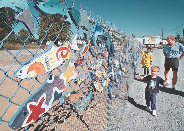
"Stream of Dreams" mural on Kingsway
https://search.heritageburnaby.ca/link/archivedescription97311
- Repository
- City of Burnaby Archives
- Date
- [2000]
- Collection/Fonds
- Burnaby NewsLeader photograph collection
- Description Level
- Item
- Physical Description
- 1 photograph (tiff) : col.
- Scope and Content
- Photograph of two unidentified children and an unidentified adult walking along the new "Stream of Dreams" mural project at Kingsway and Edmonds. The mural is made of painted wooden fish attached to a chain link fence.
- Repository
- City of Burnaby Archives
- Date
- [2000]
- Collection/Fonds
- Burnaby NewsLeader photograph collection
- Physical Description
- 1 photograph (tiff) : col.
- Description Level
- Item
- Record No.
- 535-2707
- Access Restriction
- No restrictions
- Reproduction Restriction
- Reproduce for fair dealing purposes only
- Accession Number
- 2018-12
- Scope and Content
- Photograph of two unidentified children and an unidentified adult walking along the new "Stream of Dreams" mural project at Kingsway and Edmonds. The mural is made of painted wooden fish attached to a chain link fence.
- Subjects
- Arts
- Arts - Paintings
- Structures - Fences
- Media Type
- Photograph
- Photographer
- Bartel, Mario
- Notes
- Title based on caption
- Collected by editorial for use in a September 2000 issue of the Burnaby NewsLeader
- Caption from metadata: "Passersby admire the handiwork of volunteer and school kids who cut and painted hundreds of wooden salmon for the "Stream of Dreams" project on the corner of Kingsway and Edmonds. The fence was unveiled on Saturday as part of the Edmonds Neighborhood's celebration of its community."
- Geographic Access
- Kingsway
- Edmonds Street
- Historic Neighbourhood
- Edmonds (Historic Neighbourhood)
- Planning Study Area
- Edmonds Area
- Richmond Park Area
Images
![Trans Mountain Pipe Line loading dock, [1958] thumbnail](/media/Hpo/_Data/_Archives_Images/_Unrestricted/001/098-001.jpg?width=280)
Trans Mountain Pipe Line loading dock
https://search.heritageburnaby.ca/link/archivedescription34689
- Repository
- City of Burnaby Archives
- Date
- [1958]
- Collection/Fonds
- Burnaby Historical Society fonds
- Description Level
- Item
- Physical Description
- 1 photograph : b&w ; 20.4 x 25.3 cm
- Scope and Content
- Aerial photograph of the Trans Mountain Pipe Line Westridge loading dock on Burrard Inlet. Houses are visible in the background, and railroad tracks along the edge of the inlet.
- Repository
- City of Burnaby Archives
- Date
- [1958]
- Collection/Fonds
- Burnaby Historical Society fonds
- Subseries
- Photographs subseries
- Physical Description
- 1 photograph : b&w ; 20.4 x 25.3 cm
- Description Level
- Item
- Record No.
- 098-001
- Access Restriction
- No restrictions
- Reproduction Restriction
- Reproduce for fair dealing purposes only
- Accession Number
- BHS2007-04
- Scope and Content
- Aerial photograph of the Trans Mountain Pipe Line Westridge loading dock on Burrard Inlet. Houses are visible in the background, and railroad tracks along the edge of the inlet.
- Media Type
- Photograph
- Photographer
- Commercial Illustrators Industrial Photographers
- Notes
- Title based on contents of photograph
- Stamp and annotation on back of photograph reads, "TA. 8817 / Commerical Illustrators / Industrial Photographers / 601 Denman St., Vancouver 5, B.C. / File No. 9412-2"
- Historic Neighbourhood
- Lochdale (Historic Neighbourhood)
- Planning Study Area
- Westridge Area
Images
![Trans Mountain Pipe Line loading dock, [1958] thumbnail](/media/Hpo/_Data/_Archives_Images/_Unrestricted/001/098-001.jpg)
![Two lane tunnel, [between 1947 and 1957] thumbnail](/media/hpo/_Data/_BVM_Images/2022/2022_0032_0569_001.jpg?width=280)
Two lane tunnel
https://search.heritageburnaby.ca/link/museumdescription20147
- Repository
- Burnaby Village Museum
- Date
- [between 1947 and 1957]
- Collection/Fonds
- Esther Love Stanley fonds
- Description Level
- Item
- Physical Description
- 1 photograph : b&w ; 6 x 9 cm
- Scope and Content
- Photograph of a two lane tunnel on an unidentified roadway. A garden with flowers is between the two tunnel openings.
- Repository
- Burnaby Village Museum
- Collection/Fonds
- Esther Love Stanley fonds
- Description Level
- Item
- Physical Description
- 1 photograph : b&w ; 6 x 9 cm
- Scope and Content
- Photograph of a two lane tunnel on an unidentified roadway. A garden with flowers is between the two tunnel openings.
- Subjects
- Structures
- Geographic Features - Roads
- Accession Code
- BV022.32.569
- Access Restriction
- No restrictions
- Reproduction Restriction
- No known restrictions
- Date
- [between 1947 and 1957]
- Media Type
- Photograph
- Scan Resolution
- 600
- Scan Date
- 2023-09-04
- Notes
- Title based on contents of photograph
- Photograph is part of Esther Love Stanley photograph album 2 (BV032.22.431)
Images
![Two lane tunnel, [between 1947 and 1957] thumbnail](/media/hpo/_Data/_BVM_Images/2022/2022_0032_0569_001.jpg)
![Harry Pride and Barnet townsite, [2004] thumbnail](/media/hpo/_Data/_Archives_Images/_Unrestricted/535/535-2056-1.jpg?width=280)
Harry Pride and Barnet townsite
https://search.heritageburnaby.ca/link/archivedescription96386
- Repository
- City of Burnaby Archives
- Date
- [2004]
- Collection/Fonds
- Burnaby NewsLeader photograph collection
- Description Level
- File
- Physical Description
- 3 photographs (tiff) : col.
- Scope and Content
- File contains photographs of Harry Pride at work on researching his book about Burnaby's Barnet townsite. Photographs depict Pride with Beatrice Woolsey-McMillan, a former resident of the community, on the shore of the Burrard Inlet, and Pride viewing historical photographs and one of the remaining…
- Repository
- City of Burnaby Archives
- Date
- [2004]
- Collection/Fonds
- Burnaby NewsLeader photograph collection
- Physical Description
- 3 photographs (tiff) : col.
- Description Level
- File
- Record No.
- 535-2056
- Access Restriction
- No restrictions
- Reproduction Restriction
- No restrictions
- Accession Number
- 2018-12
- Scope and Content
- File contains photographs of Harry Pride at work on researching his book about Burnaby's Barnet townsite. Photographs depict Pride with Beatrice Woolsey-McMillan, a former resident of the community, on the shore of the Burrard Inlet, and Pride viewing historical photographs and one of the remaining structures from the Barnet sawmill.
- Subjects
- Geographic Features - Inlets
- Buildings - Industrial - Saw Mills
- Buildings - Industrial - Mills
- Media Type
- Photograph
- Photographer
- Bartel, Mario
- Notes
- Title based on caption
- Collected by editorial for use in a March 2004 issue of the Burnaby NewsLeader
- Caption from metadata for 535-2056-1: "Harry Pride, who is working on a book about Burnaby's Barnet townsite, reminisces with Beatrice Woolsey-McMillan, who lived in the mill community along the Burrard Inlet from 1925-46."
- Caption from metadata for 535-2056-2: "Harry Pride sorts through some of the historical photos he's collected for a book he's working on about Burnaby's Barnet townsite, along the Burrard Inlet."
- Caption from metadata for 535-2056-3: "Harry Pride, who's working on a book about Burnaby's Barnet townsite, checks out one of the remaining structures from the sawmill that once bustled along the Burrard Inlet."
- Geographic Access
- Barnet Village
- Burrard Inlet
- Barnet Marine Park
- Historic Neighbourhood
- Barnet (Historic Neighbourhood)
- Planning Study Area
- Burnaby Mountain Area
Images
![Harry Pride and Barnet townsite, [2004] thumbnail](/media/hpo/_Data/_Archives_Images/_Unrestricted/535/535-2056-1.jpg)