Narrow Results By
Application to Operate a Small Store in the Building Now Situate at the NE Corner of Patterson Avenue and Marine Drive - Portion Block 4, DL 156
https://search.heritageburnaby.ca/link/councilreport55442
- Repository
- City of Burnaby Archives
- Report ID
- 71553
- Meeting Date
- 1-May-1935
- Format
- Council - Mayor/Councillor/Staff Report
- Collection/Fonds
- City Council and Office of the City Clerk fonds
- Repository
- City of Burnaby Archives
- Report ID
- 71553
- Meeting Date
- 1-May-1935
- Format
- Council - Mayor/Councillor/Staff Report
- Collection/Fonds
- City Council and Office of the City Clerk fonds
Documents
Construction of Sidewalk on Wilson Avenue from Patterson Avenue to John Street
https://search.heritageburnaby.ca/link/councilreport61888
- Repository
- City of Burnaby Archives
- Report ID
- 54726
- Meeting Date
- 24-Aug-1931
- Format
- Council - Mayor/Councillor/Staff Report
- Collection/Fonds
- City Council and Office of the City Clerk fonds
- Repository
- City of Burnaby Archives
- Report ID
- 54726
- Meeting Date
- 24-Aug-1931
- Format
- Council - Mayor/Councillor/Staff Report
- Collection/Fonds
- City Council and Office of the City Clerk fonds
Documents
Cost of Moving Pole at Intersection of Kingsway, Grange Street and Patterson Avenue
https://search.heritageburnaby.ca/link/councilreport55554
- Repository
- City of Burnaby Archives
- Report ID
- 71894
- Meeting Date
- 24-Jul-1935
- Format
- Council - Mayor/Councillor/Staff Report
- Collection/Fonds
- City Council and Office of the City Clerk fonds
- Repository
- City of Burnaby Archives
- Report ID
- 71894
- Meeting Date
- 24-Jul-1935
- Format
- Council - Mayor/Councillor/Staff Report
- Collection/Fonds
- City Council and Office of the City Clerk fonds
Documents
Estimate re Re Conditioning of Garbage Dump on Rumble Road West of Patterson Avenue
https://search.heritageburnaby.ca/link/councilreport64941
- Repository
- City of Burnaby Archives
- Report ID
- 56085
- Meeting Date
- 11-Aug-1930
- Format
- Council - Committee Report
- Collection/Fonds
- City Council and Office of the City Clerk fonds
- Repository
- City of Burnaby Archives
- Report ID
- 56085
- Meeting Date
- 11-Aug-1930
- Format
- Council - Committee Report
- Collection/Fonds
- City Council and Office of the City Clerk fonds
Documents
Petitions for Construction of Sidewalks on Keefer Street, Madison Avenue, Dundas Street, Ingleton Avenue, MacDonald Avenue, Willingdon Avenue, Trafalgar Street, Albert Street, Gilmore Avenue, Bond Street, Patterson Avenue, Burke Street
https://search.heritageburnaby.ca/link/councilreport64518
- Repository
- City of Burnaby Archives
- Report ID
- 55655
- Meeting Date
- 24-Mar-1930
- Format
- Council - Mayor/Councillor/Staff Report
- Collection/Fonds
- City Council and Office of the City Clerk fonds
- Repository
- City of Burnaby Archives
- Report ID
- 55655
- Meeting Date
- 24-Mar-1930
- Format
- Council - Mayor/Councillor/Staff Report
- Collection/Fonds
- City Council and Office of the City Clerk fonds
Documents
Petitions for the Construction of Sidewalks on portions of Albert Street, Willingdon Avenue, Dundas Street, Carleton Avenue, Madison Avenue, Inman Avenue, Patterson Avenue, MacDonald Avenue and Gilmore Avenue
https://search.heritageburnaby.ca/link/councilreport64543
- Repository
- City of Burnaby Archives
- Report ID
- 55679
- Meeting Date
- 7-Apr-1930
- Format
- Council - Mayor/Councillor/Staff Report
- Collection/Fonds
- City Council and Office of the City Clerk fonds
- Repository
- City of Burnaby Archives
- Report ID
- 55679
- Meeting Date
- 7-Apr-1930
- Format
- Council - Mayor/Councillor/Staff Report
- Collection/Fonds
- City Council and Office of the City Clerk fonds
Documents
Picket Camp on Patterson Avenue
https://search.heritageburnaby.ca/link/councilreport55359
- Repository
- City of Burnaby Archives
- Report ID
- 71470
- Meeting Date
- 20-Feb-1935
- Format
- Council - Mayor/Councillor/Staff Report
- Collection/Fonds
- City Council and Office of the City Clerk fonds
- Repository
- City of Burnaby Archives
- Report ID
- 71470
- Meeting Date
- 20-Feb-1935
- Format
- Council - Mayor/Councillor/Staff Report
- Collection/Fonds
- City Council and Office of the City Clerk fonds
Documents
Request for Approval for Construction of a Crematorium at the Corner of Patterson Avenue and Victory Street (Ocean View Development Co.)
https://search.heritageburnaby.ca/link/councilreport55437
- Repository
- City of Burnaby Archives
- Report ID
- 71548
- Meeting Date
- 24-Apr-1935
- Format
- Council - Mayor/Councillor/Staff Report
- Collection/Fonds
- City Council and Office of the City Clerk fonds
- Repository
- City of Burnaby Archives
- Report ID
- 71548
- Meeting Date
- 24-Apr-1935
- Format
- Council - Mayor/Councillor/Staff Report
- Collection/Fonds
- City Council and Office of the City Clerk fonds
Documents

Jubilee Grove Arch
https://search.heritageburnaby.ca/link/landmark533
- Repository
- Burnaby Heritage Planning
- Description
- The Jubilee Grove Arch sits at the corner of Kingsway and Patterson Avenue. Located within Central Park, the ceremonial arch and its decorative plantings provide a visual anchor to the northeast corner and entry point to the park.
- Associated Dates
- 1939
- Formal Recognition
- Heritage Designation, Community Heritage Register
- Street View URL
- Google Maps Street View
- Repository
- Burnaby Heritage Planning
- Geographic Access
- Imperial Street
- Associated Dates
- 1939
- Formal Recognition
- Heritage Designation, Community Heritage Register
- Enactment Type
- Bylaw No. 9807
- Enactment Date
- 23/11/1992
- Description
- The Jubilee Grove Arch sits at the corner of Kingsway and Patterson Avenue. Located within Central Park, the ceremonial arch and its decorative plantings provide a visual anchor to the northeast corner and entry point to the park.
- Heritage Value
- Jubilee Grove Arch was dedicated as part of the municipality’s celebration of the Jubilee of the coronation of King George V and was dedicated during Burnaby’s annual May Day celebrations in 1935. Much of the construction work was carried out by local citizens under the direction of the Burnaby Engineering Department through a Depression era work relief program that provided a way for local residents to pay their taxes. The garden was also chosen as the site for the ceremonial planting of an oak tree from the Royal Forest at Windsor, in honor of the Coronation of King George VI and Queen Elizabeth in 1937. The original bronze garden dedication plaque and oak tree remain at the site today. The decorative stone arch was erected in 1939 as a symbol of Burnaby's, and the Lower Mainland of British Columbia’s, strong ties to the English monarchy at the time, and the arch’s unveiling during May Day ceremonies shows the social role that such a commemorative feature played both to the local government and people of Burnaby. It was erected just prior to the Royal Visit of 1939, the first time that reigning British monarchs had travelled to Canada. Built of Haddington Island sandstone, the arch itself was reconstructed from a salvaged architectural element of a historic Vancouver landmark. The arch originally framed the entrance door to the Vancouver Club building in Vancouver, built in 1893-94 on West Hastings Street and designed by architect C.O. Wickenden. The building was demolished in 1930, however the arch was stored and rebuilt as the focal point of the Jubilee Grove after being bought by the Municipality of Burnaby. The work was undertaken by Italian-born stone mason Rizieri Stefanini (1879-1954), the owner of Burnaby Monumental Works. The re-use of the arch symbolizes the close tie between Vancouver and Burnaby and the joint evolution of the neighbouring cities.
- Defining Elements
- The Jubilee Grove Arch has character-defining elements that recognize it both as a remnant of a past building and as a new and individual structure. These include its: - axial diagonal placement and prominent corner location marking one of the entries to Central Park - visibility and accessibility as a public monument - hand carved stone blocks of Haddington Island sandstone - decorative twisted-rope motif carved to outline the arch - supporting rusticated sidewalls with planting urns - original bronze dedication plaque - flanking ornamental gardens - Royal Oak tree and plaque
- Historic Neighbourhood
- Central Park (Historic Neighbourhood)
- Planning Study Area
- Maywood Area
- Organization
- City of Burnaby
- Architect
- C.O. Wickenden
- Function
- Primary Current--Park Fixture
- Primary Historic--Park Fixture
- Community
- Burnaby
- Cadastral Identifier
- P.I.D. No. 017-767-172 Legal Description: Block B of Lot 2 Except Firstly: Part on Plan 8669 and Secondly: Part on Plan LMP4689 District Lot 151, Group 1, New Westminster District, Plan 3443
- Boundaries
- The property (Central Park) is a municipally-owned park that lies at the western edge of Burnaby, between 49th Avenue to the south, Kingsway to the north, Boundary Road to the west and Patterson Avenue to the east.
- Area
- 853,403.82
- Contributing Resource
- Structure
- Landscape Feature
- Ownership
- Public (local)
- Documentation
- Heritage Site Files: PC77000 20. City of Burnaby Planning and Building Department, 4949 Canada Way, Burnaby, B.C., V5G 1M2
- Names
- Burnaby Monumental Works
- Street Address
- 3883 Imperial Street
- Street View URL
- Google Maps Street View
Images


![Alf Hickman, [1930] (date of original), copied 1986 thumbnail](/media/hpo/_Data/_Archives_Images/_Unrestricted/204/204-242.jpg?width=280)
Alf Hickman
https://search.heritageburnaby.ca/link/archivedescription35385
- Repository
- City of Burnaby Archives
- Date
- [1930] (date of original), copied 1986
- Collection/Fonds
- Burnaby Historical Society fonds
- Description Level
- Item
- Physical Description
- 1 photograph : b&w ; 12.7 x 17.8 cm print
- Scope and Content
- Photograph of the Hickman family home at 6102 Patterson Avenue. Alf Hickman (standing beside the home) moved to Burnaby from Winnipeg and bought a store on Patterson Avenue.
- Repository
- City of Burnaby Archives
- Date
- [1930] (date of original), copied 1986
- Collection/Fonds
- Burnaby Historical Society fonds
- Subseries
- Pioneer Tales subseries
- Physical Description
- 1 photograph : b&w ; 12.7 x 17.8 cm print
- Description Level
- Item
- Record No.
- 204-242
- Access Restriction
- No restrictions
- Reproduction Restriction
- No known restrictions
- Accession Number
- BHS1988-03
- Scope and Content
- Photograph of the Hickman family home at 6102 Patterson Avenue. Alf Hickman (standing beside the home) moved to Burnaby from Winnipeg and bought a store on Patterson Avenue.
- Subjects
- Occupations - Entrepreneurs
- Names
- Hickman, Alfred "Alf"
- Media Type
- Photograph
- Notes
- Title based on contents of photograph
- Geographic Access
- Patterson Avenue
- Street Address
- 6102 Patterson Avenue
- Historic Neighbourhood
- Central Park (Historic Neighbourhood)
- Planning Study Area
- Maywood Area
Images
![Alf Hickman, [1930] (date of original), copied 1986 thumbnail](/media/hpo/_Data/_Archives_Images/_Unrestricted/204/204-242.jpg)
McKee family
https://search.heritageburnaby.ca/link/archivedescription35652
- Repository
- City of Burnaby Archives
- Date
- 1931 (date of original), copied 1986
- Collection/Fonds
- Burnaby Historical Society fonds
- Description Level
- Item
- Physical Description
- 1 photograph : b&w ; 12.7 x 17.8 cm print
- Scope and Content
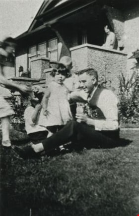
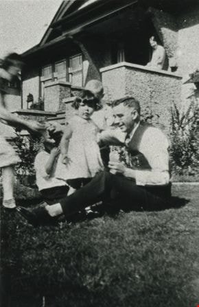
- Photograph of Dr. Boyd McKee (seated) with daughter, Doree McKee (standing next to Dr. McKee). Bessie Farthing, boarder and close family friend, is on the steps in the background. Doree McKee Piercy was also to become a doctor. The photograph was taken at the family home, 3375 Patterson Avenue (lat…
- Repository
- City of Burnaby Archives
- Date
- 1931 (date of original), copied 1986
- Collection/Fonds
- Burnaby Historical Society fonds
- Subseries
- Pioneer Tales subseries
- Physical Description
- 1 photograph : b&w ; 12.7 x 17.8 cm print
- Description Level
- Item
- Record No.
- 204-510
- Access Restriction
- No restrictions
- Reproduction Restriction
- No known restrictions
- Accession Number
- BHS1988-03
- Scope and Content
- Photograph of Dr. Boyd McKee (seated) with daughter, Doree McKee (standing next to Dr. McKee). Bessie Farthing, boarder and close family friend, is on the steps in the background. Doree McKee Piercy was also to become a doctor. The photograph was taken at the family home, 3375 Patterson Avenue (later renumbered 5790 Patterson Avenue), where the McKees lived from 1926 to 1948.
- Media Type
- Photograph
- Notes
- Title based on contents of photograph
- Geographic Access
- Patterson Avenue
- Street Address
- 5790 Patterson Avenue
- Historic Neighbourhood
- Central Park (Historic Neighbourhood)
- Planning Study Area
- Maywood Area
Images
![Jean and Ian Macdonald with newspapers, [1932] (date of original), copied 1991 thumbnail](/media/hpo/_Data/_Archives_Images/_Unrestricted/370/370-405.jpg?width=280)
Jean and Ian Macdonald with newspapers
https://search.heritageburnaby.ca/link/archivedescription37817
- Repository
- City of Burnaby Archives
- Date
- [1932] (date of original), copied 1991
- Collection/Fonds
- Burnaby Historical Society fonds
- Description Level
- Item
- Physical Description
- 1 photograph : b&w ; 2.7 x 4.7 cm print on contact sheet 20.3 x 26.4 cm
- Scope and Content
- Photograph of siblings Jean and Ian Macdonald, at Rumble Street and Patterson Avenue, holding World War One era newspapers. One of the newspapers covers the outbreak of the War and the other proclaims the end.
- Repository
- City of Burnaby Archives
- Date
- [1932] (date of original), copied 1991
- Collection/Fonds
- Burnaby Historical Society fonds
- Subseries
- Burnaby Image Bank subseries
- Physical Description
- 1 photograph : b&w ; 2.7 x 4.7 cm print on contact sheet 20.3 x 26.4 cm
- Description Level
- Item
- Record No.
- 370-405
- Access Restriction
- No restrictions
- Reproduction Restriction
- No known restrictions
- Accession Number
- BHS1999-03
- Scope and Content
- Photograph of siblings Jean and Ian Macdonald, at Rumble Street and Patterson Avenue, holding World War One era newspapers. One of the newspapers covers the outbreak of the War and the other proclaims the end.
- Subjects
- Documentary Artifacts - Newspapers
- Media Type
- Photograph
- Notes
- Title based on contents of photograph
- 1 b&w copy negative accompanying
- Negative has a pink cast
- Geographic Access
- Rumble Street
- Patterson Avenue
- Historic Neighbourhood
- Alta-Vista (Historic Neighbourhood)
Images
![Jean and Ian Macdonald with newspapers, [1932] (date of original), copied 1991 thumbnail](/media/hpo/_Data/_Archives_Images/_Unrestricted/370/370-405.jpg)
![Newton Farm, [1935] thumbnail](/media/hpo/_Data/_Archives_Images/_Unrestricted/600/625-037.jpg?width=280)
Newton Farm
https://search.heritageburnaby.ca/link/archivedescription95965
- Repository
- City of Burnaby Archives
- Date
- [1935]
- Collection/Fonds
- City of Burnaby Archives photograph collection
- Description Level
- Item
- Physical Description
- 1 photograph (tiff) : b&w
- Scope and Content
- Photograph of Newton Farm, located at Patterson Avenue and Marine Drive.
- Repository
- City of Burnaby Archives
- Date
- [1935]
- Collection/Fonds
- City of Burnaby Archives photograph collection
- Physical Description
- 1 photograph (tiff) : b&w
- Description Level
- Item
- Record No.
- 625-037
- Access Restriction
- No restrictions
- Reproduction Restriction
- No known restrictions
- Accession Number
- 2013-31
- Scope and Content
- Photograph of Newton Farm, located at Patterson Avenue and Marine Drive.
- Subjects
- Agriculture - Farms
- Media Type
- Photograph
- Notes
- Title based on content of photograph
- Geographic Access
- Patterson Avenue
- Marine Drive
- Historic Neighbourhood
- Fraser Arm (Historic Neighbourhood)
Images
![Newton Farm, [1935] thumbnail](/media/hpo/_Data/_Archives_Images/_Unrestricted/600/625-037.jpg)
![Riverway West Baptist Mission, [between 1930 and 1958] thumbnail](/media/hpo/_Data/_Archives_Images/_Unrestricted/251/269-010.jpg?width=280)
Riverway West Baptist Mission
https://search.heritageburnaby.ca/link/archivedescription36425
- Repository
- City of Burnaby Archives
- Date
- [between 1930 and 1958]
- Collection/Fonds
- Burnaby Historical Society fonds
- Description Level
- Item
- Physical Description
- 1 photograph : b&w copy negative ; 35 mm
- Scope and Content
- Photograph of a large group standing on the steps at the front entrance to the Riverway West Baptist Mission. A sign on the right advertises Sunday School and the times for morning worship.
- Repository
- City of Burnaby Archives
- Date
- [between 1930 and 1958]
- Collection/Fonds
- Burnaby Historical Society fonds
- Subseries
- Kay North subseries
- Physical Description
- 1 photograph : b&w copy negative ; 35 mm
- Description Level
- Item
- Record No.
- 269-010
- Access Restriction
- No restrictions
- Reproduction Restriction
- Reproduce for fair dealing purposes only
- Accession Number
- BHS1991-38
- Scope and Content
- Photograph of a large group standing on the steps at the front entrance to the Riverway West Baptist Mission. A sign on the right advertises Sunday School and the times for morning worship.
- Media Type
- Photograph
- Notes
- Title based on contents of photograph
- Geographic Access
- Marine Drive
- Patterson Avenue
- Historic Neighbourhood
- Fraser Arm (Historic Neighbourhood)
- Planning Study Area
- Big Bend Area
Images
![Riverway West Baptist Mission, [between 1930 and 1958] thumbnail](/media/hpo/_Data/_Archives_Images/_Unrestricted/251/269-010.jpg)
![Rumble Road, [1930] thumbnail](/media/hpo/_Data/_Archives_Images/_Unrestricted/204/204-022.jpg?width=280)
Rumble Road
https://search.heritageburnaby.ca/link/archivedescription35165
- Repository
- City of Burnaby Archives
- Date
- [1930]
- Collection/Fonds
- Burnaby Historical Society fonds
- Description Level
- Item
- Physical Description
- 1 photograph : b&w ; 12.7 x 17.8 cm
- Scope and Content
- Photograph of Rumble Road east of Patterson.
- Repository
- City of Burnaby Archives
- Date
- [1930]
- Collection/Fonds
- Burnaby Historical Society fonds
- Subseries
- Pioneer Tales subseries
- Physical Description
- 1 photograph : b&w ; 12.7 x 17.8 cm
- Description Level
- Item
- Record No.
- 204-022
- Access Restriction
- No restrictions
- Reproduction Restriction
- No known restrictions
- Accession Number
- BHS1988-03
- Scope and Content
- Photograph of Rumble Road east of Patterson.
- Subjects
- Geographic Features - Roads
- Media Type
- Photograph
- Photographer
- Stone, Gene
- Notes
- Title based on contents of photograph
- Geographic Access
- Rumble Street
- Patterson Avenue
- Historic Neighbourhood
- Alta-Vista (Historic Neighbourhood)
- Planning Study Area
- Sussex-Nelson Area
Images
![Rumble Road, [1930] thumbnail](/media/hpo/_Data/_Archives_Images/_Unrestricted/204/204-022.jpg)

Rumble Street
https://search.heritageburnaby.ca/link/archivedescription34255
- Repository
- City of Burnaby Archives
- Date
- 1932
- Collection/Fonds
- Burnaby Historical Society fonds
- Description Level
- Item
- Physical Description
- 1 photograph : b&w ; 12.2 x 17.7 cm
- Scope and Content
- Photograph of Rumble Street looking east toward Patterson Avenue, located where the house on the left can be seen.
- Repository
- City of Burnaby Archives
- Date
- 1932
- Collection/Fonds
- Burnaby Historical Society fonds
- Subseries
- Photographs subseries
- Physical Description
- 1 photograph : b&w ; 12.2 x 17.7 cm
- Description Level
- Item
- Record No.
- 011-002
- Access Restriction
- No restrictions
- Reproduction Restriction
- No known restrictions
- Accession Number
- BHS2007-04
- Scope and Content
- Photograph of Rumble Street looking east toward Patterson Avenue, located where the house on the left can be seen.
- Media Type
- Photograph
- Notes
- Title based on contents of photograph
- Annotation at bottom of Copy 2 reads, "Rumble St. just after Municipal dump was filled / Facing east house on left is where Patterson Avenue [is]"
- Geographic Access
- Rumble Street
- Patterson Avenue
- Historic Neighbourhood
- Alta-Vista (Historic Neighbourhood)
- Planning Study Area
- Sussex-Nelson Area
- Suncrest Area
Images

![Sunday School children, [193-] thumbnail](/media/hpo/_Data/_Archives_Images/_Unrestricted/251/269-015.jpg?width=280)
Sunday School children
https://search.heritageburnaby.ca/link/archivedescription53963
- Repository
- City of Burnaby Archives
- Date
- [193-]
- Collection/Fonds
- Burnaby Historical Society fonds
- Description Level
- Item
- Physical Description
- 1 photograph : b&w copy negative ; 35 mm
- Scope and Content
- Photograph of the Riverway Mission Sunday School bus parked outside of the Riverway Mission. The Sunday School children are all standing out in front of the truck, in the front yard.
- Repository
- City of Burnaby Archives
- Date
- [193-]
- Collection/Fonds
- Burnaby Historical Society fonds
- Subseries
- Kay North subseries
- Physical Description
- 1 photograph : b&w copy negative ; 35 mm
- Description Level
- Item
- Record No.
- 269-015
- Access Restriction
- No restrictions
- Reproduction Restriction
- No known restrictions
- Accession Number
- BHS1991-38
- Scope and Content
- Photograph of the Riverway Mission Sunday School bus parked outside of the Riverway Mission. The Sunday School children are all standing out in front of the truck, in the front yard.
- Subjects
- Buildings - Religious - Churches
- Media Type
- Photograph
- Notes
- Title based on contents of photograph
- Geographic Access
- Marine Drive
- Patterson Avenue
- Historic Neighbourhood
- Fraser Arm (Historic Neighbourhood)
- Planning Study Area
- Big Bend Area
Images
![Sunday School children, [193-] thumbnail](/media/hpo/_Data/_Archives_Images/_Unrestricted/251/269-015.jpg)
Patterson family subseries
https://search.heritageburnaby.ca/link/archivedescription32
- Repository
- City of Burnaby Archives
- Date
- 1898-1952
- Collection/Fonds
- Burnaby Historical Society fonds
- Description Level
- Subseries
- Physical Description
- Textual records and photographs
- Scope and Content
- Subseries consists of documents and photographs pertaining to the Patterson family.
- Repository
- City of Burnaby Archives
- Date
- 1898-1952
- Collection/Fonds
- Burnaby Historical Society fonds
- Subseries
- Patterson family subseries
- Physical Description
- Textual records and photographs
- Description Level
- Subseries
- Accession Number
- BHS1986-19
- BHS1986-20
- BHS1988-13
- BHS1995-16
- BHS1996-05
- BHS1996-11
- Scope and Content
- Subseries consists of documents and photographs pertaining to the Patterson family.
- History
- Frances Mabel "May" Webb was born in Cradley, England on December 5, 1872. She sailed from England to Victoria, BC with her parents, Joseph William Webb and Frances Jane Webb (nee Yapp) on the SS Lake Winnipeg in 1889. One of the few possessions that she brought with her was an old wood-rimmed bicycle which she found quite useful after her move to Burnaby. She would ride it all the way from Patterson’s Trail and Westminster Road (today’s Patterson Avenue and Kingsway) to the Woodward’s store in Vancouver where she would place her grocery order. She packed a pearl handled revolver with her in order to scare any bears she might see along her ride. In 1890, Frances married Dugald Campbell Patterson (b. 1860, d. 1931) in Victoria, BC. In 1894, the couple built a pioneer homestead and farm on five acres at what would become the north east section of Central Park. Dugald founded Vulcan Iron Works (later Dominion Bridge Company) in New Westminister in 1903, and the couple settled in the Central Park district. By 1904, the family moved to the Edmonds district where in 1909 she operated the post office that her husband founded. In 1910, they began construction of a new house, complete with tennis courts and a gazebo, on 14 acres purchased for $720. The house is now located at 7106 18th Avenue and is a dedicated heritage building. The couple had seven children: William H. "Bill", Jean, Frances Mabel Lili., Dugald C. Jr, Mary, Charles Bruce, and Alice. The Pattersons were community-minded citizens that served Burnaby through their involvement with local municipal affairs and politics. In 1909, Dugald became the first postmaster of Edmonds. He also served as a School Trustee from 1912-13 and was one of the first residents to lobby Burnaby City Council to preserve the local ravines as parks. They also helped build the Central Park Presbyterian Church, along with other pioneer families. The family name is remembered and honoured by the naming of Patterson Avenue and the Patterson SkyTrain Station located in the Metrotown area. Frances Mabel assisted her husband with an insurance and real estate company that he founded in Burnaby and New Westminster. This experience would prove invaluable, as she would later become an insurance agent for the Wawanesa Insurance Company (founded in 1896). Frances never owned an automobile, so she met her insurance clients all over Burnaby, New Westminster and Vancouver by using the Lower Mainland’s street car system. The insurance profession continued to provide her with a steady income long after her husband’s death. Frances Mabel died in New Westminster, BC on August 30, 1960. Frances Mabel Lili Patterson was born on June 9, 1905 and was the fifth child born to Dugald Campbell and Frances Mabel Patterson. She became the first PBX switchboard operator for the Municipality of Burnaby in the early 1920’s. PBX, or Private Branch Exchange, was the term used for an internal telephone system. Frances later became president of the Professional Women’s Association of New Westminster, and volunteered her time with the May Day celebrations in New Westminster. She was also a dedicated member of the Rebekah Lodge (the women’s division of the Independent Order of Odd Fellows). While in the lodge, she met her future husband, Walter Duke and they married on July 12, 1939. They couple moved to Wenatchee, Washington after getting married, and Frances relocated to Victoria after her husband died. Frances died on January 13, 1974. Doreen Nettie Patterson was born December 12, 1927, the youngest daughter of Charles Bruce Patterson and Elva Eleanore Patterson (nee Elliott). At age 23, Doreen became the first woman from BC to enlist in the new Women’s Royal Canadian Naval Service and by the fall of 1951, she had become a Wren in the Royal Canadian Navy. She received her basic training at HMCS Cornwallis and became a radio intelligence operator for the wireless communications base at Naval Radio Station Coverdale near Moncton, New Brunswick. In 1953, she was chosen to serve a term at the naval base in Churchill, Manitoba. She was one of only eleven women to ever serve there. After her career in the navy, Doreen worked in the accounting division for Simpsons-Sears in Burnaby near her grandparent’s original family home at Patterson Avenue and Kingsway. Doreen married Gerard Reitsma on August 18, 1960. Doreen died on April 30, 2000.
- Media Type
- Textual Record
- Photograph
- Notes
- Title based on contents of subseries
- PC171, PC213, PC322, PC326, MSS024, MSS039
Field family fonds
https://search.heritageburnaby.ca/link/archivedescription65767
- Repository
- City of Burnaby Archives
- Date
- [1915] - [1969]
- Collection/Fonds
- Field family fonds
- Description Level
- Fonds
- Physical Description
- 31 photographs : tiffs ; 600 ppi + 0.5 cm of textual records
- Scope and Content
- Fonds consists of photographs of the Field family and their relatives, including the Sandersons, as well as notes used by Thomas Sanderson in preparation of an address he gave in 1934 titled "The Early Development of Our Lumber Industry with Historical Sketches."
- Repository
- City of Burnaby Archives
- Date
- [1915] - [1969]
- Collection/Fonds
- Field family fonds
- Physical Description
- 31 photographs : tiffs ; 600 ppi + 0.5 cm of textual records
- Description Level
- Fonds
- Accession Number
- 2010-14
- 2012-24
- Scope and Content
- Fonds consists of photographs of the Field family and their relatives, including the Sandersons, as well as notes used by Thomas Sanderson in preparation of an address he gave in 1934 titled "The Early Development of Our Lumber Industry with Historical Sketches."
- History
- William “Willie“ James Field was born to William and Rebecca (Chambers) December of 1881 in England. Laura Tonkin was born to John Charles and Amelia (Johns) February of 1887 in Wales. Her brother, Charles Henry “Harry” was born in 1888. In 1907, Laura Tonkin married Willie James Field. Their first child, Phyllis Laura, was born in 1910. In 1912, the young family of three immigrated to Canada, arriving firstly in Hamilton, Ontario, where Willie James ran a welding business. Both Willie’s youngest brother, Arthur Pearcy, and Laura’s only brother, Charles Henry “Harry”, joined them soon after. The extended family of five then moved west to Moose Jaw, Saskatchewan. But Arthur Percy soon returned to Hamilton, married Sara Umbach, and had their two children, Arthur and June. Laura and Willie returned to Wales with Phyllis to have their second child, William John “John”, in 1914. War broke out and they were stranded until 1919. Within that time, Harry also returned to England with his bride, Ethyl “Em.” In 1919, the Field and Tonkin families returned to Moose Jaw, Saskatchewan, before heading out west. Willie James Field or Harry Tonkin owned the Model T-Ford convertible that the extended family travelled west in, arriving in Central Park, Burnaby, around 1921. Amelia and John Charles Tonkin purchased a home on Wilson Avenue where they lived out the rest of their lives. Amelia died on March 6, 1944, at the age of 82. Harry and Em Tonkin bought property on Nelson Avenue and began their family with a son, Roy, who unfortunately, did not survive infancy. He had a sister, Marjorie, born 1927. Willie James and Laura bought property on Patterson Avenue and had two more children: Dorothy, born October 10, 1925, and Robert George, born September 6, 1927. In 1929, June Field was brought out from Ontario as tuberculosis had claimed both her parents. The Mackenzies of Central Park adopted her and she became June Mackenzie at the age of three. Her older brother Arthur stayed in a foster home in Ontario. When June lost both her adoptive parents, Arthur came to Burnaby and he and his sister became a members of the Patterson Avenue Field family. In 1937, Phyllis Field married Gordon John Sanderson, the son of Ellen Jane Garvin and former Burnaby Reeve Thomas Sanderson. William James Field died March 17, 1965, at the age of 83, his wife Laura died in 1968 at the age of 81. William John “John” and Margaret (Begg) Field had their daughter Lorraine in 1941 and Joyce shortly after. Robert George married Edna Schilthelm of Mandy Avenue in Burnaby, and had William George “Bill”, Elizabeth “Betty” Gorrie, Joan Katherine Nash and Susan Carol Hanniford. All live locally, except Joan who lives in Royston.
- Media Type
- Photograph
- Creator
- Field family
- Notes
- Title based on contents of fonds
- Photo catalogue 521, MSS168
Bylaw Number: 1048 - Local Improvement Debenture Bylaw No 6, 1930
https://search.heritageburnaby.ca/link/bylaw22406
- Repository
- Legislative Services
- Bylaw Number
- 1048
- Final Adoption
- 1930 Apr 22
- Format
- Bylaws - Adopted
- Collection/Fonds
- City Council and Office of the City Clerk fonds
- Repository
- Legislative Services
- Bylaw Number
- 1048
- Final Adoption
- 1930 Apr 22
- Format
- Bylaws - Adopted
- Collection/Fonds
- City Council and Office of the City Clerk fonds