More like 'Interview with Sev Morin by Rod Fowler April 4, 1990 - Track 3'

E.W. Bateman House 'Elworth'
https://search.heritageburnaby.ca/link/landmark538
- Repository
- Burnaby Heritage Planning
- Description
- The E.W. Bateman House is a one-and-one-half storey wood-frame residence set within in a garden landscape. The house and its adjacent garage are the only historic buildings standing on their original site within the Burnaby Village Museum property.
- Associated Dates
- 1922
- Formal Recognition
- Heritage Designation, Community Heritage Register
- Other Names
- Edwin & Mary Bateman Residence
- Street View URL
- Google Maps Street View
- Repository
- Burnaby Heritage Planning
- Other Names
- Edwin & Mary Bateman Residence
- Geographic Access
- Deer Lake Avenue
- Associated Dates
- 1922
- Formal Recognition
- Heritage Designation, Community Heritage Register
- Enactment Type
- Bylaw No. 9807
- Enactment Date
- 23/11/1992
- Description
- The E.W. Bateman House is a one-and-one-half storey wood-frame residence set within in a garden landscape. The house and its adjacent garage are the only historic buildings standing on their original site within the Burnaby Village Museum property.
- Heritage Value
- The E.W. Bateman House was constructed in the Deer Lake Crescent subdivision, that was originally promoted in 1911 as an upper class suburban neighbourhood. It represents one of the first residential developments in the City of Burnaby that required buildings to be of a specific value, thus demonstrating the desire for exclusivity among the successful businessmen who chose to settle in the area. The house and grounds illustrate the reduced scale of upper-class residential construction at a time of modest returning prosperity that followed the end of the First World War, and the social, cultural, lifestyle and leisure sensibilities of the owners in the Deer Lake Crescent subdivision: such values as social aspiration, racial exclusivity, demonstration of architectural taste, and importance of a landscaped garden. The heritage value of the E.W. Bateman House is its comprehensive representation of an upper middle-class suburban residence of the early 1920s. It was built for retired CPR executive Edwin Wettenhall Bateman (1859-1957) and his wife, Mary (Dale) Bateman (1865-1935), by contractor William Dodson in 1922. The Bateman House was designed by English-born and trained architect Enoch Evans (1862-1939) of E. Evans and Son, and is an important surviving residential design by Evans, and a typical example of the eclectic Period Revival influences that were common to domestic architecture in the post-First World War era. The symmetry of the imposing front verandah, supported by exaggerated Ionic columns, gives the relatively-modest house an image of grandeur and formality. Named after Edwin Bateman’s birthplace in Cheshire, England, ‘Elworth’ also symbolizes allegiance to England and the patriotic tenor of the time. The heritage value for this house also lies in its interpretive value within the Burnaby Village Museum. The site is an important cultural feature for the interpretation of Burnaby’s heritage to the public. The E.W. Bateman House was purchased by Burnaby in 1970 and became the focal point for the development of the Museum. Both the interior and exterior of the house have been restored and interpreted to the date of original construction, including recreated room interiors and period furnishings.
- Defining Elements
- The elements that define the heritage character of the E.W. Bateman House include its: - rectangular form and massing with central entry on long side - side gable roof with front shed dormer with cedar shingle cladding - symmetry of front facade - full open front verandah inset under the roofline, supported with Ionic columns - cedar shingle siding - multi-paned double-hung wooden-sash windows, mixture of 6-over-1 and 8-over-1 - symmetrical disposition of fenestration, with double-assembly units on the ground floor - exterior shutters - two flanking brick chimneys on the side elevations - interior room layouts and original interior features such as quality millwork and original hardware - original garage at the rear of the house
- Locality
- Deer Lake Park
- Historic Neighbourhood
- Burnaby Lake (Historic Neighbourhood)
- Planning Study Area
- Morley-Buckingham Area
- Organization
- Burnaby Village Museum
- Architect
- Enoch Evans
- E. Evans and Son
- Builder
- William Dodson
- Function
- Primary Current--Museum
- Primary Historic--Single Dwelling
- Community
- Burnaby
- Cadastral Identifier
- P.I.D. No. 011-030-356 Legal Description: Parcel 1, District Lot 79 and District Lot 85, Group 1, New Westminster District, Reference Plan 77594
- Boundaries
- Burnaby Village Museum is comprised of a single municipally-owned property located at 6501 Deer Lake Avenue, Burnaby.
- Area
- 38,488.63
- Contributing Resource
- Building
- Landscape Feature
- Structure
- Ownership
- Public (local)
- Documentation
- Heritage Site Files: PC77000 20. City of Burnaby Planning and Building Department, 4949 Canada Way, Burnaby, B.C., V5G 1M2
- Subjects
- Buildings - Residential
- Buildings - Residential - Houses
- Buildings - Heritage
- Buildings - Civic - Museums
- Street Address
- 6501 Deer Lake Avenue
- Street View URL
- Google Maps Street View
Images


Barnet Lumber Company House
https://search.heritageburnaby.ca/link/landmark662
- Repository
- Burnaby Heritage Planning
- Description
- Residential building.
- Associated Dates
- 1925
- Street View URL
- Google Maps Street View
- Repository
- Burnaby Heritage Planning
- Geographic Access
- Texaco Drive
- Associated Dates
- 1925
- Description
- Residential building.
- Heritage Value
- This house is one of two surviving houses built as a “Model Home” for the manager of the Barnet Lumber Company, which was the successor to the North Pacific Lumber Company. It was used as a combined home and office. It was constructed with framing lumber and millwork sawn at the mill. Typical of the Craftsman style, the house has a front gabled roof with triangular eave brackets. It has been altered with the addition of asbestos shingles over the original siding, but retains its form, scale and massing. This house was designed by the firm of Townley & Matheson. The partnership of Fred Laughton Townley (1887-1966) and Robert Michael Matheson began in 1919, and the firm left a rich legacy of sophisticated work, including schools, commercial structures, many fine residences and the landmark Vancouver City Hall.
- Historic Neighbourhood
- Barnet (Historic Neighbourhood)
- Planning Study Area
- Burnaby Mountain Area
- Architect
- Townley & Matheson
- Area
- 2225.77
- Contributing Resource
- Building
- Ownership
- Public (local)
- Street Address
- 8007 Texaco Drive
- Street View URL
- Google Maps Street View
Images


Barnet Lumber Company House
https://search.heritageburnaby.ca/link/landmark663
- Repository
- Burnaby Heritage Planning
- Description
- Residential building.
- Associated Dates
- 1925
- Street View URL
- Google Maps Street View
- Repository
- Burnaby Heritage Planning
- Geographic Access
- Texaco Drive
- Associated Dates
- 1925
- Description
- Residential building.
- Heritage Value
- This house is one of two surviving houses built as a “Model Home” for one of the assistant managers of the Barnet Lumber Company, using framing lumber and millwork sawn at the mill. This house was also designed by the firm of Townley & Matheson. The house was raised and renovated in 1997, resulting in alterations such as new dormers and elongated porch piers.
- Historic Neighbourhood
- Barnet (Historic Neighbourhood)
- Planning Study Area
- Burnaby Mountain Area
- Architect
- Townley & Matheson
- Contributing Resource
- Building
- Ownership
- Private
- Street Address
- 8039 Texaco Drive
- Street View URL
- Google Maps Street View
Images


Capitol Hill School
https://search.heritageburnaby.ca/link/landmark564
- Repository
- Burnaby Heritage Planning
- Description
- School building.
- Associated Dates
- 1923
- Other Names
- Ecole Capitol Hill Elementary School
- Street View URL
- Google Maps Street View
- Repository
- Burnaby Heritage Planning
- Other Names
- Ecole Capitol Hill Elementary School
- Geographic Access
- Holdom Avenue
- Associated Dates
- 1923
- Description
- School building.
- Heritage Value
- This school was originally designed by Bowman & Cullerne as a two-storey, four-room school building in 1923, with a two-room addition completed in 1926 and another in 1927. Originally designed in the Arts and Crafts style, it has been altered, with the addition of stucco over the original siding and replacement windows, but has retained its original form and massing, as well as its roof-top ventilator and front gabled entrance with grouped columns. Bowman & Cullerne specialized in school design. After Harold Cullerne (1890-1976) returned from service during the First World War, he joined J.H. Bowman (1864-1943) in a partnership that lasted from 1919 to 1934. The firm’s other school designs included Seaforth School (1922, now relocated to Burnaby Village Museum), Burnaby North High School (1923), and Nelson Avenue School (1927).
- Locality
- Capitol Hill
- Historic Neighbourhood
- Capitol Hill (Historic Neighbourhood)
- Planning Study Area
- Capitol Hill Area
- Architect
- Bowman & Cullerne
- Ownership
- Public (local)
- Subjects
- Buildings - Heritage
- Buildings - Schools
- Street Address
- 350 Holdom Avenue
- Street View URL
- Google Maps Street View
Images


Douglas Road School
https://search.heritageburnaby.ca/link/landmark573
- Repository
- Burnaby Heritage Planning
- Description
- School building.
- Associated Dates
- 1928
- Other Names
- Douglas Road Elementary School
- Street View URL
- Google Maps Street View
- Repository
- Burnaby Heritage Planning
- Other Names
- Douglas Road Elementary School
- Geographic Access
- Canada Way
- Associated Dates
- 1928
- Description
- School building.
- Heritage Value
- The Douglas Road School was originally established as a two-room school in 1908 on this site, and later expanded to four classrooms. Anticipating rapid settlement of this district, the School Board purchased two acres adjoining the old building. Two of the four rooms were designed to become one large auditorium suitable for special events and public gatherings, with seating for two hundred people. The classically-influenced school has been altered with new windows and extended with additional wings, but has retained its original red-brick veneer, tan-brick quoins and bellcast octagonal roof ventilator. Designed by McCarter & Nairne, the school was built by contractor A.S. Perry. McCarter & Nairne, who also designed the Second Street School, were the Burnaby School Board architects at this time. John Y. McCarter (1886-1981) and George Nairne (1884-1953) formed their partnership in 1921 after serving overseas during the First World War. The partners began designing houses and small apartment buildings, and their commissions included Vancouver’s first skyscraper, the Marine Building (1928-30).
- Locality
- Burnaby Lake
- Historic Neighbourhood
- Burnaby Lake (Historic Neighbourhood)
- Planning Study Area
- Douglas-Gilpin Area
- Architect
- McCarter & Nairne
- Subjects
- Buildings - Heritage
- Buildings - Schools
- Street Address
- 4861 Canada Way
- Street View URL
- Google Maps Street View
Images


![G.R. Heyworth, [192-] (date of original), copied 1986 thumbnail](/media/hpo/_Data/_Archives_Images/_Unrestricted/126/187-004.jpg?width=280)
G.R. Heyworth
https://search.heritageburnaby.ca/link/archivedescription35071
- Repository
- City of Burnaby Archives
- Date
- [192-] (date of original), copied 1986
- Collection/Fonds
- Burnaby Historical Society fonds
- Description Level
- Item
- Physical Description
- 1 photograph : b&w ; 14.7 x 8.9 cm
- Scope and Content
- Photograph of G.R. Heyworth standing outside Jubilee Drug Store, Jubilee Avenue and Imperial Street (later the location of Bonsor Park, 6550 Bonsor Avenue). Signs read, "Jubilee Drug [Store] / G.R. [Heyworth]" and "Ask for Keystone Brand School Supplies." Magazines and school supplies are display…
- Repository
- City of Burnaby Archives
- Date
- [192-] (date of original), copied 1986
- Collection/Fonds
- Burnaby Historical Society fonds
- Subseries
- Heyworth family subseries
- Physical Description
- 1 photograph : b&w ; 14.7 x 8.9 cm
- Description Level
- Item
- Record No.
- 187-004
- Access Restriction
- No restrictions
- Reproduction Restriction
- No known restrictions
- Accession Number
- BHS1986-38
- Scope and Content
- Photograph of G.R. Heyworth standing outside Jubilee Drug Store, Jubilee Avenue and Imperial Street (later the location of Bonsor Park, 6550 Bonsor Avenue). Signs read, "Jubilee Drug [Store] / G.R. [Heyworth]" and "Ask for Keystone Brand School Supplies." Magazines and school supplies are displayed in the window. Note the dirt road.
- Media Type
- Photograph
- Notes
- Title based on contents of photograph
- Stamp on verso of photograph reads: "5580"
- Geographic Access
- Jubilee Avenue
- Bonsor Avenue
- Street Address
- 6550 Bonsor Avenue
- Historic Neighbourhood
- Central Park (Historic Neighbourhood)
- Planning Study Area
- Marlborough Area
Images
![G.R. Heyworth, [192-] (date of original), copied 1986 thumbnail](/media/hpo/_Data/_Archives_Images/_Unrestricted/126/187-004.jpg)
![Entrance to Oasis Tourist Camp, [192-] thumbnail](/media/hpo/_Data/_BVM_Images/1977/1977_0121_0003_001.jpg?width=280)
Entrance to Oasis Tourist Camp
https://search.heritageburnaby.ca/link/museumdescription594
- Repository
- Burnaby Village Museum
- Date
- [192-]
- Collection/Fonds
- Roy Bernard Raymer fonds
- Description Level
- Item
- Physical Description
- 1 photograph : sepia ; 8.6 x 15.1 cm
- Scope and Content
- Photograph of the entrance to Oasis Tourist Camp, which is marked by a large sign put up with two posts on either side of the sign . It reads, "Tea Gardens / The Oasis / 'Rest and Refresh' / Free Tourist Camp." Further along the driveway is a smaller sign that reads: "'Welcome.' Drive In." To the…
- Repository
- Burnaby Village Museum
- Collection/Fonds
- Roy Bernard Raymer fonds
- Description Level
- Item
- Physical Description
- 1 photograph : sepia ; 8.6 x 15.1 cm
- Scope and Content
- Photograph of the entrance to Oasis Tourist Camp, which is marked by a large sign put up with two posts on either side of the sign . It reads, "Tea Gardens / The Oasis / 'Rest and Refresh' / Free Tourist Camp." Further along the driveway is a smaller sign that reads: "'Welcome.' Drive In." To the left of the entrance is a modified house building with a sign advertising for Fraser Valley ice cream placed outside the extended patio. The Oasis Tourist Camp was located at 2675 Kingsway (after 1959 address became 6105 Kingsway) in Burnaby and was owned and operated by the Raymer family.
- Names
- Oasis
- Geographic Access
- Kingsway
- Street Address
- 6105 Kingsway
- Accession Code
- HV977.121.3
- Access Restriction
- No restrictions
- Reproduction Restriction
- No known restrictions
- Date
- [192-]
- Media Type
- Photograph
- Planning Study Area
- Windsor Area
- Scan Resolution
- 600
- Scan Date
- 23-Aug-06
- Scale
- 100
- Notes
- Title based on contents of photograph
Images
![Entrance to Oasis Tourist Camp, [192-] thumbnail](/media/hpo/_Data/_BVM_Images/1977/1977_0121_0003_001.jpg)

The Hot Dog Inn and proprietors
https://search.heritageburnaby.ca/link/archivedescription34311
- Repository
- City of Burnaby Archives
- Date
- 1924
- Collection/Fonds
- Burnaby Historical Society fonds
- Description Level
- Item
- Physical Description
- 1 photograph : b&w ; 8 x 12.9 cm on page 17.5 x 24.5 cm
- Scope and Content
- Photograph of the hot dog stand built at Deer Lake for ice skaters. Standing in front of it are the "proprietors" A. D. Bowker and Abe Rowe. The sign affixed to the stand reads: "This Is The Hot Dog Inn And It's Cold Outside / Come Right In / Coffee 5 cents / Hot Dogs 10 cents".
- Repository
- City of Burnaby Archives
- Date
- 1924
- Collection/Fonds
- Burnaby Historical Society fonds
- Subseries
- Peers family subseries
- Physical Description
- 1 photograph : b&w ; 8 x 12.9 cm on page 17.5 x 24.5 cm
- Description Level
- Item
- Record No.
- 020-018
- Access Restriction
- No restrictions
- Reproduction Restriction
- No known restrictions
- Accession Number
- BHS2007-04
- Scope and Content
- Photograph of the hot dog stand built at Deer Lake for ice skaters. Standing in front of it are the "proprietors" A. D. Bowker and Abe Rowe. The sign affixed to the stand reads: "This Is The Hot Dog Inn And It's Cold Outside / Come Right In / Coffee 5 cents / Hot Dogs 10 cents".
- Subjects
- Buildings - Commercial - Restaurants
- Structures - Tents
- Advertising Medium - Signs and Signboards
- Names
- Bowker, A.D.
- Rowe, Abe
- Media Type
- Photograph
- Notes
- Title based on caption accompanying photograph
- Geographic Access
- Deer Lake
- Historic Neighbourhood
- Burnaby Lake (Historic Neighbourhood)
- Planning Study Area
- Morley-Buckingham Area
Images

Oasis Restaurant
https://search.heritageburnaby.ca/link/archivedescription35629
- Repository
- City of Burnaby Archives
- Date
- 1926 (date of original), copied 1986
- Collection/Fonds
- Burnaby Historical Society fonds
- Description Level
- Item
- Physical Description
- 1 photograph : b&w ; 12.7 x 17.8 cm print
- Scope and Content
- Photograph of The Oasis restaurant, store, and night club (with dance floor), formerly The Oasis tea room. The Oasis was located at 2675 Kingsway (Pacific Highway). It was later renumbered 6105 Kingsway.
- Repository
- City of Burnaby Archives
- Date
- 1926 (date of original), copied 1986
- Collection/Fonds
- Burnaby Historical Society fonds
- Subseries
- Pioneer Tales subseries
- Physical Description
- 1 photograph : b&w ; 12.7 x 17.8 cm print
- Description Level
- Item
- Record No.
- 204-487
- Access Restriction
- No restrictions
- Reproduction Restriction
- No known restrictions
- Accession Number
- BHS1988-03
- Scope and Content
- Photograph of The Oasis restaurant, store, and night club (with dance floor), formerly The Oasis tea room. The Oasis was located at 2675 Kingsway (Pacific Highway). It was later renumbered 6105 Kingsway.
- Subjects
- Buildings - Commercial - Restaurants
- Names
- Oasis
- Media Type
- Photograph
- Notes
- Title based on contents of photograph
- Geographic Access
- Kingsway
- Street Address
- 6105 Kingsway
- Planning Study Area
- Windsor Area
Images
![The Oasis Suburban Café, [192-] thumbnail](/media/hpo/_Data/_Archives_Images/_Unrestricted/316/326-001.jpg?width=280)
The Oasis Suburban Café
https://search.heritageburnaby.ca/link/archivedescription37171
- Repository
- City of Burnaby Archives
- Date
- [192-]
- Collection/Fonds
- Burnaby Historical Society fonds
- Description Level
- Item
- Physical Description
- 1 photograph : sepia postcard ; 9.5 x 14 cm
- Scope and Content
- Photographic postcard of "'THE OASIS,' SUBURBAN CAFE" on Kingsway.
- Repository
- City of Burnaby Archives
- Date
- [192-]
- Collection/Fonds
- Burnaby Historical Society fonds
- Subseries
- Patterson family subseries
- Physical Description
- 1 photograph : sepia postcard ; 9.5 x 14 cm
- Description Level
- Item
- Record No.
- 326-001
- Access Restriction
- No restrictions
- Reproduction Restriction
- No known restrictions
- Accession Number
- BHS1996-11
- Scope and Content
- Photographic postcard of "'THE OASIS,' SUBURBAN CAFE" on Kingsway.
- Names
- Oasis
- Media Type
- Photograph
- Notes
- Annotation on recto of postcard reads: "'THE OASIS, SUBURBAN CAFE / A place of Refinement and Good Food. - On the Highway between New Westminster and Vancouver"
- Typed on verso of postcard reads: " Vancouver, B.C. / Dear ___________/ We just had Chicken Dinner at "The Oasis" Suburban Cafe, and I must say it was a real treat, everything was so tasty. If ever you motor up to Vancouver be sure and stop there. It is right on the Pacific Highway at 2675 Kingsway East, about three miles from New Westminster, and 20 minutes run from the Hotel Vancouver."
- Geographic Access
- Kingsway
- Street Address
- 6105 Kingsway
- Planning Study Area
- Windsor Area
Images
![The Oasis Suburban Café, [192-] thumbnail](/media/hpo/_Data/_Archives_Images/_Unrestricted/316/326-001.jpg)
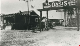
Oasis Tea Garden and Tourist Camp
https://search.heritageburnaby.ca/link/archivedescription35623
- Repository
- City of Burnaby Archives
- Date
- 1925 (date of original), copied 1986
- Collection/Fonds
- Burnaby Historical Society fonds
- Description Level
- Item
- Physical Description
- 1 photograph : b&w ; 12.7 x 17.8 cm print
- Scope and Content
- Photograph of the Oasis tea garden and tourist camp at 2675 Kingsway (Pacific Highway). It was later renumbered 6105 Kingsway. Guests could pitch tents for free at the campground and patronize the tea garden. The complex was operated by the Raymer family.
- Repository
- City of Burnaby Archives
- Date
- 1925 (date of original), copied 1986
- Collection/Fonds
- Burnaby Historical Society fonds
- Subseries
- Pioneer Tales subseries
- Physical Description
- 1 photograph : b&w ; 12.7 x 17.8 cm print
- Description Level
- Item
- Record No.
- 204-481
- Access Restriction
- No restrictions
- Reproduction Restriction
- No known restrictions
- Accession Number
- BHS1988-03
- Scope and Content
- Photograph of the Oasis tea garden and tourist camp at 2675 Kingsway (Pacific Highway). It was later renumbered 6105 Kingsway. Guests could pitch tents for free at the campground and patronize the tea garden. The complex was operated by the Raymer family.
- Names
- Oasis
- Media Type
- Photograph
- Notes
- Title based on contents of photograph
- Geographic Access
- Kingsway
- Street Address
- 6105 Kingsway
- Planning Study Area
- Windsor Area
Images

![Ed Brown and daughters with his truck, [1925] thumbnail](/media/hpo/_Data/_Archives_Images/_Unrestricted/251/298-009.jpg?width=280)
Ed Brown and daughters with his truck
https://search.heritageburnaby.ca/link/archivedescription46007
- Repository
- City of Burnaby Archives
- Date
- [1925]
- Collection/Fonds
- Ed Brown Family fonds
- Description Level
- Item
- Physical Description
- 1 jpg. : b&w
- Scope and Content
- Photograph of Ed Brown and his daughters on one of his trucks.
- Repository
- City of Burnaby Archives
- Date
- [1925]
- Collection/Fonds
- Ed Brown Family fonds
- Physical Description
- 1 jpg. : b&w
- Description Level
- Item
- Record No.
- 298-009
- Access Restriction
- No restrictions
- Reproduction Restriction
- No known restrictions
- Accession Number
- 2008-03
- Scope and Content
- Photograph of Ed Brown and his daughters on one of his trucks.
- Media Type
- Photograph
- Notes
- Title based on contents of photograph
Images
![Ed Brown and daughters with his truck, [1925] thumbnail](/media/hpo/_Data/_Archives_Images/_Unrestricted/251/298-009.jpg)
![Ed Brown and his daughters, [1920] thumbnail](/media/hpo/_Data/_Archives_Images/_Unrestricted/251/298-004.jpg?width=280)
Ed Brown and his daughters
https://search.heritageburnaby.ca/link/archivedescription46002
- Repository
- City of Burnaby Archives
- Date
- [1920]
- Collection/Fonds
- Ed Brown Family fonds
- Description Level
- Item
- Physical Description
- 1 jpg. : b&w
- Scope and Content
- Photograph of Ed Brown and four of his daughters sitting in one of Ed's trucks (a GMC).
- Repository
- City of Burnaby Archives
- Date
- [1920]
- Collection/Fonds
- Ed Brown Family fonds
- Physical Description
- 1 jpg. : b&w
- Description Level
- Item
- Record No.
- 298-004
- Access Restriction
- No restrictions
- Reproduction Restriction
- No known restrictions
- Accession Number
- 2008-03
- Scope and Content
- Photograph of Ed Brown and four of his daughters sitting in one of Ed's trucks (a GMC).
- Media Type
- Photograph
- Notes
- Title based on contents of photograph
- Geographic Access
- Royal Oak Avenue
Images
![Ed Brown and his daughters, [1920] thumbnail](/media/hpo/_Data/_Archives_Images/_Unrestricted/251/298-004.jpg)
![Ed Brown and his daughters, [1920] thumbnail](/media/hpo/_Data/_Archives_Images/_Unrestricted/251/298-008.jpg?width=280)
Ed Brown and his daughters
https://search.heritageburnaby.ca/link/archivedescription46006
- Repository
- City of Burnaby Archives
- Date
- [1920]
- Collection/Fonds
- Ed Brown Family fonds
- Description Level
- Item
- Physical Description
- 1 jpg. : b&w
- Scope and Content
- Photograph of Ed Brown and his daughters on one of his trucks.
- Repository
- City of Burnaby Archives
- Date
- [1920]
- Collection/Fonds
- Ed Brown Family fonds
- Physical Description
- 1 jpg. : b&w
- Description Level
- Item
- Record No.
- 298-008
- Access Restriction
- No restrictions
- Reproduction Restriction
- No known restrictions
- Accession Number
- 2008-03
- Scope and Content
- Photograph of Ed Brown and his daughters on one of his trucks.
- Media Type
- Photograph
- Notes
- Title based on contents of photograph
Images
![Ed Brown and his daughters, [1920] thumbnail](/media/hpo/_Data/_Archives_Images/_Unrestricted/251/298-008.jpg)
![Ed Brown and his daughters, [1925] thumbnail](/media/hpo/_Data/_Archives_Images/_Unrestricted/251/298-010.jpg?width=280)
Ed Brown and his daughters
https://search.heritageburnaby.ca/link/archivedescription46008
- Repository
- City of Burnaby Archives
- Date
- [1925]
- Collection/Fonds
- Ed Brown Family fonds
- Description Level
- Item
- Physical Description
- 1 jpg. : b&w
- Scope and Content
- Photograph of Ed Brown and his daughters on one of his trucks.
- Repository
- City of Burnaby Archives
- Date
- [1925]
- Collection/Fonds
- Ed Brown Family fonds
- Physical Description
- 1 jpg. : b&w
- Description Level
- Item
- Record No.
- 298-010
- Access Restriction
- No restrictions
- Reproduction Restriction
- No known restrictions
- Accession Number
- 2008-03
- Scope and Content
- Photograph of Ed Brown and his daughters on one of his trucks.
- Media Type
- Photograph
- Notes
- Title based on contents of photograph
Images
![Ed Brown and his daughters, [1925] thumbnail](/media/hpo/_Data/_Archives_Images/_Unrestricted/251/298-010.jpg)
![Ed Brown beside his transfer truck, [1920] thumbnail](/media/hpo/_Data/_Archives_Images/_Unrestricted/251/298-002.jpg?width=280)
Ed Brown beside his transfer truck
https://search.heritageburnaby.ca/link/archivedescription36573
- Repository
- City of Burnaby Archives
- Date
- [1920]
- Collection/Fonds
- Burnaby Historical Society fonds
- Description Level
- Item
- Physical Description
- 1 photograph : sepia ; 6 x 10.5 cm
- Scope and Content
- Photograph of Ed Brown standing beside his truck that is loaded with telephone poles.
- Repository
- City of Burnaby Archives
- Date
- [1920]
- Collection/Fonds
- Burnaby Historical Society fonds
- Subseries
- Ed Brown family subseries
- Physical Description
- 1 photograph : sepia ; 6 x 10.5 cm
- Description Level
- Item
- Record No.
- 298-002
- Access Restriction
- No restrictions
- Reproduction Restriction
- No known restrictions
- Accession Number
- BHS1992-38
- Scope and Content
- Photograph of Ed Brown standing beside his truck that is loaded with telephone poles.
- Media Type
- Photograph
- Notes
- Title based on contents of photograph
- Geographic Access
- Royal Oak Avenue
Images
![Ed Brown beside his transfer truck, [1920] thumbnail](/media/hpo/_Data/_Archives_Images/_Unrestricted/251/298-002.jpg)
![Ed Brown sitting on his transfer truck, [1920] thumbnail](/media/hpo/_Data/_Archives_Images/_Unrestricted/251/298-003.jpg?width=280)
Ed Brown sitting on his transfer truck
https://search.heritageburnaby.ca/link/archivedescription36574
- Repository
- City of Burnaby Archives
- Date
- [1920]
- Collection/Fonds
- Burnaby Historical Society fonds
- Description Level
- Item
- Physical Description
- 1 photograph : sepia ; 6 x 10.5 cm
- Scope and Content
- Photograph of Ed Brown and Morton Kidd sitting on top of Ed's transfer truck that has been loaded with telephone poles.
- Repository
- City of Burnaby Archives
- Date
- [1920]
- Collection/Fonds
- Burnaby Historical Society fonds
- Subseries
- Ed Brown family subseries
- Physical Description
- 1 photograph : sepia ; 6 x 10.5 cm
- Description Level
- Item
- Record No.
- 298-003
- Access Restriction
- No restrictions
- Reproduction Restriction
- No known restrictions
- Accession Number
- BHS1992-38
- Scope and Content
- Photograph of Ed Brown and Morton Kidd sitting on top of Ed's transfer truck that has been loaded with telephone poles.
- Media Type
- Photograph
- Notes
- Title based on contents of photograph.
- Geographic Access
- Royal Oak Avenue
Images
![Ed Brown sitting on his transfer truck, [1920] thumbnail](/media/hpo/_Data/_Archives_Images/_Unrestricted/251/298-003.jpg)
![Charles R. Gillmore, [192-] (date of original), copied 1986 thumbnail](/media/hpo/_Data/_Archives_Images/_Unrestricted/204/204-252.jpg?width=280)
Charles R. Gillmore
https://search.heritageburnaby.ca/link/archivedescription35395
- Repository
- City of Burnaby Archives
- Date
- [192-] (date of original), copied 1986
- Collection/Fonds
- Burnaby Historical Society fonds
- Description Level
- Item
- Physical Description
- 1 photograph : b&w ; 12.7 x 17.8 cm print
- Scope and Content
- Photograph of Charles R. Gillmore, operator of Fernhurst Game Farm near Imperial Street and Dow Avenue. This later became the site of Maywood Elementary School at 4567 Imperial Street.
- Repository
- City of Burnaby Archives
- Date
- [192-] (date of original), copied 1986
- Collection/Fonds
- Burnaby Historical Society fonds
- Subseries
- Pioneer Tales subseries
- Physical Description
- 1 photograph : b&w ; 12.7 x 17.8 cm print
- Description Level
- Item
- Record No.
- 204-252
- Access Restriction
- No restrictions
- Reproduction Restriction
- No known restrictions
- Accession Number
- BHS1988-03
- Scope and Content
- Photograph of Charles R. Gillmore, operator of Fernhurst Game Farm near Imperial Street and Dow Avenue. This later became the site of Maywood Elementary School at 4567 Imperial Street.
- Media Type
- Photograph
- Notes
- Title based on contents of photograph
- Geographic Access
- Imperial Street
- Street Address
- 4567 Imperial Street
- Historic Neighbourhood
- Central Park (Historic Neighbourhood)
- Planning Study Area
- Maywood Area
Images
![Charles R. Gillmore, [192-] (date of original), copied 1986 thumbnail](/media/hpo/_Data/_Archives_Images/_Unrestricted/204/204-252.jpg)
![G.R. and George Heyworth, [192-] thumbnail](/media/hpo/_Data/_Archives_Images/_Unrestricted/126/187-003.jpg?width=280)
G.R. and George Heyworth
https://search.heritageburnaby.ca/link/archivedescription35070
- Repository
- City of Burnaby Archives
- Date
- [192-]
- Collection/Fonds
- Burnaby Historical Society fonds
- Description Level
- Item
- Physical Description
- 1 photograph : b&w ; 13.6 x 10.1 cm
- Scope and Content
- Photograph of Mr. G.R. Heyworth and his son, George taken in a photographic Studio. An annotation on the back of the photograph reads, "G.R. (Rollie) Heyworth and son George operated Jubilee Drug Store, corner of Imperial St. and Jubilee Ave. in the late 1920-30-40s. Jubilee Ave. was called Maple …
- Repository
- City of Burnaby Archives
- Date
- [192-]
- Collection/Fonds
- Burnaby Historical Society fonds
- Subseries
- Heyworth family subseries
- Physical Description
- 1 photograph : b&w ; 13.6 x 10.1 cm
- Description Level
- Item
- Record No.
- 187-003
- Access Restriction
- No restrictions
- Reproduction Restriction
- No known restrictions
- Accession Number
- BHS1986-38
- Scope and Content
- Photograph of Mr. G.R. Heyworth and his son, George taken in a photographic Studio. An annotation on the back of the photograph reads, "G.R. (Rollie) Heyworth and son George operated Jubilee Drug Store, corner of Imperial St. and Jubilee Ave. in the late 1920-30-40s. Jubilee Ave. was called Maple Ave. in the early days and the odd block has the name in cement at the end of the block. / Home: Lived on Victory Street."
- Media Type
- Photograph
- Notes
- Title based on contents of photograph
Images
![G.R. and George Heyworth, [192-] thumbnail](/media/hpo/_Data/_Archives_Images/_Unrestricted/126/187-003.jpg)
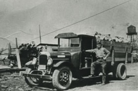
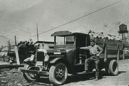
J. Engelland Fuels truck
https://search.heritageburnaby.ca/link/archivedescription35810
- Repository
- City of Burnaby Archives
- Date
- 1929 (date of original), copied 1986
- Collection/Fonds
- Burnaby Historical Society fonds
- Description Level
- Item
- Physical Description
- 1 photograph : b&w ; 12.7 x 17.8 cm print
- Scope and Content
- Photograph of John Engelland with a 1929 Federal truck used to deliver coal, wood and sawdust for J. Engelland Fuels.
- Repository
- City of Burnaby Archives
- Date
- 1929 (date of original), copied 1986
- Collection/Fonds
- Burnaby Historical Society fonds
- Subseries
- Pioneer Tales subseries
- Physical Description
- 1 photograph : b&w ; 12.7 x 17.8 cm print
- Description Level
- Item
- Record No.
- 204-668
- Access Restriction
- No restrictions
- Reproduction Restriction
- No known restrictions
- Accession Number
- BHS1988-03
- Scope and Content
- Photograph of John Engelland with a 1929 Federal truck used to deliver coal, wood and sawdust for J. Engelland Fuels.
- Media Type
- Photograph
- Notes
- Title based on contents of photograph
Images