More like 'B.G. Walker house'
Narrow Results By
Decade
- 2020s 87
- 2010s 46
- 2000s 496
- 1990s 418
- 1980s
- 1970s 818
- 1960s 323
- 1950s 480
- 1940s 535
- 1930s 401
- 1920s
- 1910s 517
- 1900s 227
- 1890s 46
- 1880s 57
- 1870s 6
- 1860s 4
- 1850s 3
- 1840s 1
- 1830s 2
- 1820s 1
- 1810s 1
- 1800s 1
- 1790s 1
- 1780s 1
- 1770s 1
- 1760s 1
- 1750s 1
- 1740s 1
- 1730s 1
- 1720s 1
- 1710s 1
- 1700s 1
- 1690s 1
- 1680s 1
- 1670s 1
- 1660s 1
- 1650s 1
- 1640s 1
- 1630s 1
- 1620s 1
- 1610s 1
- 1600s 1

E.W. Bateman House 'Elworth'
https://search.heritageburnaby.ca/link/landmark538
- Repository
- Burnaby Heritage Planning
- Description
- The E.W. Bateman House is a one-and-one-half storey wood-frame residence set within in a garden landscape. The house and its adjacent garage are the only historic buildings standing on their original site within the Burnaby Village Museum property.
- Associated Dates
- 1922
- Formal Recognition
- Heritage Designation, Community Heritage Register
- Other Names
- Edwin & Mary Bateman Residence
- Street View URL
- Google Maps Street View
- Repository
- Burnaby Heritage Planning
- Other Names
- Edwin & Mary Bateman Residence
- Geographic Access
- Deer Lake Avenue
- Associated Dates
- 1922
- Formal Recognition
- Heritage Designation, Community Heritage Register
- Enactment Type
- Bylaw No. 9807
- Enactment Date
- 23/11/1992
- Description
- The E.W. Bateman House is a one-and-one-half storey wood-frame residence set within in a garden landscape. The house and its adjacent garage are the only historic buildings standing on their original site within the Burnaby Village Museum property.
- Heritage Value
- The E.W. Bateman House was constructed in the Deer Lake Crescent subdivision, that was originally promoted in 1911 as an upper class suburban neighbourhood. It represents one of the first residential developments in the City of Burnaby that required buildings to be of a specific value, thus demonstrating the desire for exclusivity among the successful businessmen who chose to settle in the area. The house and grounds illustrate the reduced scale of upper-class residential construction at a time of modest returning prosperity that followed the end of the First World War, and the social, cultural, lifestyle and leisure sensibilities of the owners in the Deer Lake Crescent subdivision: such values as social aspiration, racial exclusivity, demonstration of architectural taste, and importance of a landscaped garden. The heritage value of the E.W. Bateman House is its comprehensive representation of an upper middle-class suburban residence of the early 1920s. It was built for retired CPR executive Edwin Wettenhall Bateman (1859-1957) and his wife, Mary (Dale) Bateman (1865-1935), by contractor William Dodson in 1922. The Bateman House was designed by English-born and trained architect Enoch Evans (1862-1939) of E. Evans and Son, and is an important surviving residential design by Evans, and a typical example of the eclectic Period Revival influences that were common to domestic architecture in the post-First World War era. The symmetry of the imposing front verandah, supported by exaggerated Ionic columns, gives the relatively-modest house an image of grandeur and formality. Named after Edwin Bateman’s birthplace in Cheshire, England, ‘Elworth’ also symbolizes allegiance to England and the patriotic tenor of the time. The heritage value for this house also lies in its interpretive value within the Burnaby Village Museum. The site is an important cultural feature for the interpretation of Burnaby’s heritage to the public. The E.W. Bateman House was purchased by Burnaby in 1970 and became the focal point for the development of the Museum. Both the interior and exterior of the house have been restored and interpreted to the date of original construction, including recreated room interiors and period furnishings.
- Defining Elements
- The elements that define the heritage character of the E.W. Bateman House include its: - rectangular form and massing with central entry on long side - side gable roof with front shed dormer with cedar shingle cladding - symmetry of front facade - full open front verandah inset under the roofline, supported with Ionic columns - cedar shingle siding - multi-paned double-hung wooden-sash windows, mixture of 6-over-1 and 8-over-1 - symmetrical disposition of fenestration, with double-assembly units on the ground floor - exterior shutters - two flanking brick chimneys on the side elevations - interior room layouts and original interior features such as quality millwork and original hardware - original garage at the rear of the house
- Locality
- Deer Lake Park
- Historic Neighbourhood
- Burnaby Lake (Historic Neighbourhood)
- Planning Study Area
- Morley-Buckingham Area
- Organization
- Burnaby Village Museum
- Architect
- Enoch Evans
- E. Evans and Son
- Builder
- William Dodson
- Function
- Primary Current--Museum
- Primary Historic--Single Dwelling
- Community
- Burnaby
- Cadastral Identifier
- P.I.D. No. 011-030-356 Legal Description: Parcel 1, District Lot 79 and District Lot 85, Group 1, New Westminster District, Reference Plan 77594
- Boundaries
- Burnaby Village Museum is comprised of a single municipally-owned property located at 6501 Deer Lake Avenue, Burnaby.
- Area
- 38,488.63
- Contributing Resource
- Building
- Landscape Feature
- Structure
- Ownership
- Public (local)
- Documentation
- Heritage Site Files: PC77000 20. City of Burnaby Planning and Building Department, 4949 Canada Way, Burnaby, B.C., V5G 1M2
- Subjects
- Buildings - Residential
- Buildings - Residential - Houses
- Buildings - Heritage
- Buildings - Civic - Museums
- Street Address
- 6501 Deer Lake Avenue
- Street View URL
- Google Maps Street View
Images


Barnet Lumber Company House
https://search.heritageburnaby.ca/link/landmark662
- Repository
- Burnaby Heritage Planning
- Description
- Residential building.
- Associated Dates
- 1925
- Street View URL
- Google Maps Street View
- Repository
- Burnaby Heritage Planning
- Geographic Access
- Texaco Drive
- Associated Dates
- 1925
- Description
- Residential building.
- Heritage Value
- This house is one of two surviving houses built as a “Model Home” for the manager of the Barnet Lumber Company, which was the successor to the North Pacific Lumber Company. It was used as a combined home and office. It was constructed with framing lumber and millwork sawn at the mill. Typical of the Craftsman style, the house has a front gabled roof with triangular eave brackets. It has been altered with the addition of asbestos shingles over the original siding, but retains its form, scale and massing. This house was designed by the firm of Townley & Matheson. The partnership of Fred Laughton Townley (1887-1966) and Robert Michael Matheson began in 1919, and the firm left a rich legacy of sophisticated work, including schools, commercial structures, many fine residences and the landmark Vancouver City Hall.
- Historic Neighbourhood
- Barnet (Historic Neighbourhood)
- Planning Study Area
- Burnaby Mountain Area
- Architect
- Townley & Matheson
- Area
- 2225.77
- Contributing Resource
- Building
- Ownership
- Public (local)
- Street Address
- 8007 Texaco Drive
- Street View URL
- Google Maps Street View
Images


Barnet Lumber Company House
https://search.heritageburnaby.ca/link/landmark663
- Repository
- Burnaby Heritage Planning
- Description
- Residential building.
- Associated Dates
- 1925
- Street View URL
- Google Maps Street View
- Repository
- Burnaby Heritage Planning
- Geographic Access
- Texaco Drive
- Associated Dates
- 1925
- Description
- Residential building.
- Heritage Value
- This house is one of two surviving houses built as a “Model Home” for one of the assistant managers of the Barnet Lumber Company, using framing lumber and millwork sawn at the mill. This house was also designed by the firm of Townley & Matheson. The house was raised and renovated in 1997, resulting in alterations such as new dormers and elongated porch piers.
- Historic Neighbourhood
- Barnet (Historic Neighbourhood)
- Planning Study Area
- Burnaby Mountain Area
- Architect
- Townley & Matheson
- Contributing Resource
- Building
- Ownership
- Private
- Street Address
- 8039 Texaco Drive
- Street View URL
- Google Maps Street View
Images


Capitol Hill School
https://search.heritageburnaby.ca/link/landmark564
- Repository
- Burnaby Heritage Planning
- Description
- School building.
- Associated Dates
- 1923
- Other Names
- Ecole Capitol Hill Elementary School
- Street View URL
- Google Maps Street View
- Repository
- Burnaby Heritage Planning
- Other Names
- Ecole Capitol Hill Elementary School
- Geographic Access
- Holdom Avenue
- Associated Dates
- 1923
- Description
- School building.
- Heritage Value
- This school was originally designed by Bowman & Cullerne as a two-storey, four-room school building in 1923, with a two-room addition completed in 1926 and another in 1927. Originally designed in the Arts and Crafts style, it has been altered, with the addition of stucco over the original siding and replacement windows, but has retained its original form and massing, as well as its roof-top ventilator and front gabled entrance with grouped columns. Bowman & Cullerne specialized in school design. After Harold Cullerne (1890-1976) returned from service during the First World War, he joined J.H. Bowman (1864-1943) in a partnership that lasted from 1919 to 1934. The firm’s other school designs included Seaforth School (1922, now relocated to Burnaby Village Museum), Burnaby North High School (1923), and Nelson Avenue School (1927).
- Locality
- Capitol Hill
- Historic Neighbourhood
- Capitol Hill (Historic Neighbourhood)
- Planning Study Area
- Capitol Hill Area
- Architect
- Bowman & Cullerne
- Ownership
- Public (local)
- Subjects
- Buildings - Heritage
- Buildings - Schools
- Street Address
- 350 Holdom Avenue
- Street View URL
- Google Maps Street View
Images


Douglas Road School
https://search.heritageburnaby.ca/link/landmark573
- Repository
- Burnaby Heritage Planning
- Description
- School building.
- Associated Dates
- 1928
- Other Names
- Douglas Road Elementary School
- Street View URL
- Google Maps Street View
- Repository
- Burnaby Heritage Planning
- Other Names
- Douglas Road Elementary School
- Geographic Access
- Canada Way
- Associated Dates
- 1928
- Description
- School building.
- Heritage Value
- The Douglas Road School was originally established as a two-room school in 1908 on this site, and later expanded to four classrooms. Anticipating rapid settlement of this district, the School Board purchased two acres adjoining the old building. Two of the four rooms were designed to become one large auditorium suitable for special events and public gatherings, with seating for two hundred people. The classically-influenced school has been altered with new windows and extended with additional wings, but has retained its original red-brick veneer, tan-brick quoins and bellcast octagonal roof ventilator. Designed by McCarter & Nairne, the school was built by contractor A.S. Perry. McCarter & Nairne, who also designed the Second Street School, were the Burnaby School Board architects at this time. John Y. McCarter (1886-1981) and George Nairne (1884-1953) formed their partnership in 1921 after serving overseas during the First World War. The partners began designing houses and small apartment buildings, and their commissions included Vancouver’s first skyscraper, the Marine Building (1928-30).
- Locality
- Burnaby Lake
- Historic Neighbourhood
- Burnaby Lake (Historic Neighbourhood)
- Planning Study Area
- Douglas-Gilpin Area
- Architect
- McCarter & Nairne
- Subjects
- Buildings - Heritage
- Buildings - Schools
- Street Address
- 4861 Canada Way
- Street View URL
- Google Maps Street View
Images


![Stride family home, [between 1915 and 1920] thumbnail](/media/hpo/_Data/_Archives_Images/_Unrestricted/001/001-001.jpg?width=280)
Stride family home
https://search.heritageburnaby.ca/link/archivedescription34025
- Repository
- City of Burnaby Archives
- Date
- [between 1915 and 1920]
- Collection/Fonds
- Burnaby Historical Society fonds
- Description Level
- Item
- Physical Description
- 1 photograph : sepia postcard ; 8 x 14 cm
- Scope and Content
- Photographic postcard of the exterior of the Stride family home located at Kingsway and 18th Avenue. Two people are traveling in a Model T Ford (with the top down) along the street in front of the house.
- Repository
- City of Burnaby Archives
- Date
- [between 1915 and 1920]
- Collection/Fonds
- Burnaby Historical Society fonds
- Subseries
- Stride family subseries
- Physical Description
- 1 photograph : sepia postcard ; 8 x 14 cm
- Description Level
- Item
- Record No.
- 001-001
- Access Restriction
- No restrictions
- Reproduction Restriction
- No known restrictions
- Accession Number
- BHS2007-04
- Scope and Content
- Photographic postcard of the exterior of the Stride family home located at Kingsway and 18th Avenue. Two people are traveling in a Model T Ford (with the top down) along the street in front of the house.
- Subjects
- Buildings - Residential - Houses
- Documentary Artifacts - Postcards
- Transportation - Automobiles
- Media Type
- Photograph
- Notes
- Title based on contents of photograph
- Geographic Access
- Kingsway
- 18th Avenue
- Historic Neighbourhood
- Edmonds (Historic Neighbourhood)
Images
![Stride family home, [between 1915 and 1920] thumbnail](/media/hpo/_Data/_Archives_Images/_Unrestricted/001/001-001.jpg)
Interview with Reidun Seim by Kathy Bossort January 13, 2016 - Track 1
https://search.heritageburnaby.ca/link/oralhistory650
- Repository
- City of Burnaby Archives
- Date Range
- 1904-1940
- Length
- 0:11:22
- Summary
- This portion of the interview is about Reidun Seim talking about her father’s immigration to the USA in 1904 at age 16, his return to Norway and marrying Martine, her parents emigration from Norway to Vancouver in 1930, her father’s purchase of an acre of land on Curtis Street and building a two ro…
- Repository
- City of Burnaby Archives
- Summary
- This portion of the interview is about Reidun Seim talking about her father’s immigration to the USA in 1904 at age 16, his return to Norway and marrying Martine, her parents emigration from Norway to Vancouver in 1930, her father’s purchase of an acre of land on Curtis Street and building a two room house for the family, Reidun’s birth in 1931, and the family’s move to Curtis Street in 1932. She talks about her childhood memories of playing on a big stump and cedar log in the yard.
- Date Range
- 1904-1940
- Length
- 0:11:22
- Names
- Seim, Sjur
- Seim, Martine
- Geographic Access
- Curtis Street
- Historic Neighbourhood
- Lochdale (Historic Neighbourhood)
- Planning Study Area
- Lochdale Area
- Interviewer
- Bossort, Kathy
- Interview Date
- January 13, 2016
- Scope and Content
- Recording is of an interview with Reidun Seim conducted by Kathy Bossort. Reidun Seim was one of 23 participants interviewed as part of the Community Heritage Commission’s Burnaby Mountain Oral History Project. The interview is mainly about Reidun Seim’s memories about her parent’s farm on Curtis Street, events in her childhood, and the people who lived in or visited her neighborhood. She takes us on a tour of her neighborhood in the 1940s, telling us stories about families who lived on Curtis Street on and east of 7300 block, including people who lived on Burnaby Mountain in the old Hastings Grove subdivision above the end of municipal water service at Philips Avenue. She describes changes to Curtis Street, particularly after it provided access to Simon Fraser University in 1965. She also talks about her teaching career, and about how she values the green space and conservation area on Burnaby Mountain.
- Biographical Notes
- Reidun Seim was born in 1931 in Vancouver B.C. to Sjur and Martine Seim. Sjur and Martine Seim emigrated to Canada from Norway in 1930, and after settling in Vancouver, moved to an acre of land and a new home at the base of Burnaby Mountain in 1932. Sjur attended UBC to learn about poultry farming and began his own chicken and egg business in 1935. The farm animals and large garden also contributed to the family’s livelihood and self-sufficiency. The Curtis Street neighborhood was a lively place and extended well up Curtis Street on the west slope of Burnaby Mountain, where Reidun would babysit for families. Reidun attended Sperling Avenue Elementary School (Gr. 1-8), Burnaby North High School, and Vancouver Normal School for teacher training in 1950-1951. She began teaching primary grades in Port Coquitlam at James Park School. Most of her career was spent in North Delta, teaching at Kennedy and Annieville schools from 1954-1958, appointed Primary Consultant (1958-1960) and Primary Supervisor (1960-1985), before retiring in 1986. Reidun lived at home with her parents on Curtis Street, commuting to Delta, and continues to live in the original farmhouse.
- Total Tracks
- 14
- Total Length
- 2:35:58
- Interviewee Name
- Seim, Reidun
- Interview Location
- Burnaby City Hall in the Law Library
- Interviewer Bio
- Kathy Bossort is a retired archivist living in Ladner, BC. She worked at the Delta Museum and Archives after graduating from SLAIS (UBC) in 2001 with Masters degrees in library science and archival studies. Kathy grew up in Calgary, Alberta, and, prior to this career change, she lived in the West Kootenays, earning her living as a cook for BC tourist lodges and work camps. She continues to be interested in oral histories as a way to fill the gaps in the written record and bring richer meaning to history.
- Collection/Fonds
- Community Heritage Commission Special Projects fonds
- Media Type
- Sound Recording
Audio Tracks
Track one of interview with Reidun Seim
Track one of interview with Reidun Seim
https://search.heritageburnaby.ca/media/hpo/_Data/_Archives_Oral_Histories/_Unrestricted/MSS196-017/MSS196-017_Track_1.mp3
Aeroplane view of the Barnet Lumber Co.
https://search.heritageburnaby.ca/link/archivedescription38679
- Repository
- City of Burnaby Archives
- Date
- 1927
- Collection/Fonds
- Burnaby Historical Society fonds
- Description Level
- Item
- Physical Description
- 1 photograph : sepia postcard ; 8.9 x 13.4 cm
- Scope and Content
- Aerial photographic postcard of Barnet Lumber Company's Mill. The handwritten caption on the lower left corner of the postcard reads: "Aeroplane view of the Barnet Lumber Co. Ltd./ Barnet BC." The handwritten caption on the lower right corner reads: "Copyright 1927/ Pacific Airway Ltd./ Vancouver …
- Repository
- City of Burnaby Archives
- Date
- 1927
- Collection/Fonds
- Burnaby Historical Society fonds
- Subseries
- North Burnaby Board of Trade subseries
- Physical Description
- 1 photograph : sepia postcard ; 8.9 x 13.4 cm
- Description Level
- Item
- Record No.
- 476-022
- Access Restriction
- No restrictions
- Reproduction Restriction
- No known restrictions
- Accession Number
- BHS2005-8
- Scope and Content
- Aerial photographic postcard of Barnet Lumber Company's Mill. The handwritten caption on the lower left corner of the postcard reads: "Aeroplane view of the Barnet Lumber Co. Ltd./ Barnet BC." The handwritten caption on the lower right corner reads: "Copyright 1927/ Pacific Airway Ltd./ Vancouver B.C.".
- Subjects
- Aerial Photographs
- Industries - Forestry
- Buildings - Industrial - Mills
- Documentary Artifacts - Postcards
- Industries - Logging/lumber
- Names
- Barnet Mill
- Media Type
- Photograph
- Photographer
- Pacific Airway Ltd.
- Responsibility
- Published by the Gowen, Sutton Co. Ltd., Vancouver
- Notes
- Transcribed title
- Geographic Access
- Barnet Village
- Texaco Drive
- Street Address
- 8059 Texaco Drive
- Historic Neighbourhood
- Barnet (Historic Neighbourhood)
- Planning Study Area
- Burnaby Mountain Area
Images

![Central Park Auto Tourist Grounds, Vancouver Canada, [1923] thumbnail](/media/hpo/_Data/_Archives_Images/_Unrestricted/371/449-007.jpg?width=280)
Central Park Auto Tourist Grounds, Vancouver Canada
https://search.heritageburnaby.ca/link/archivedescription38512
- Repository
- City of Burnaby Archives
- Date
- [1923]
- Collection/Fonds
- Burnaby Historical Society fonds
- Description Level
- Item
- Physical Description
- 1 photograph : sepia postcard ; 9 x 14 cm
- Scope and Content
- Photographic postcard of the Central Park auto tourist grounds. Two unidentified men can be seen standing in front of a car which is parked next to the campground building. In the background, a clothesline has been strung holding towels and blankets.
- Repository
- City of Burnaby Archives
- Date
- [1923]
- Collection/Fonds
- Burnaby Historical Society fonds
- Subseries
- Photographs subseries
- Physical Description
- 1 photograph : sepia postcard ; 9 x 14 cm
- Description Level
- Item
- Record No.
- 449-007
- Access Restriction
- No restrictions
- Reproduction Restriction
- No known restrictions
- Accession Number
- BHS2007-04
- Scope and Content
- Photographic postcard of the Central Park auto tourist grounds. Two unidentified men can be seen standing in front of a car which is parked next to the campground building. In the background, a clothesline has been strung holding towels and blankets.
- Subjects
- Buildings - Commercial - Hotels and Motels
- Geographic Features - Parks
- Documentary Artifacts - Postcards
- Recreational Activities - Camping
- Media Type
- Photograph
- Notes
- Title based on caption
- Geographic Access
- Central Park
- Imperial Street
- Street Address
- 3883 Imperial Street
- Historic Neighbourhood
- Central Park (Historic Neighbourhood)
- Planning Study Area
- Maywood Area
Images
![Central Park Auto Tourist Grounds, Vancouver Canada, [1923] thumbnail](/media/hpo/_Data/_Archives_Images/_Unrestricted/371/449-007.jpg)
![The Oasis Suburban Café, [192-] thumbnail](/media/hpo/_Data/_Archives_Images/_Unrestricted/316/326-001.jpg?width=280)
The Oasis Suburban Café
https://search.heritageburnaby.ca/link/archivedescription37171
- Repository
- City of Burnaby Archives
- Date
- [192-]
- Collection/Fonds
- Burnaby Historical Society fonds
- Description Level
- Item
- Physical Description
- 1 photograph : sepia postcard ; 9.5 x 14 cm
- Scope and Content
- Photographic postcard of "'THE OASIS,' SUBURBAN CAFE" on Kingsway.
- Repository
- City of Burnaby Archives
- Date
- [192-]
- Collection/Fonds
- Burnaby Historical Society fonds
- Subseries
- Patterson family subseries
- Physical Description
- 1 photograph : sepia postcard ; 9.5 x 14 cm
- Description Level
- Item
- Record No.
- 326-001
- Access Restriction
- No restrictions
- Reproduction Restriction
- No known restrictions
- Accession Number
- BHS1996-11
- Scope and Content
- Photographic postcard of "'THE OASIS,' SUBURBAN CAFE" on Kingsway.
- Names
- Oasis
- Media Type
- Photograph
- Notes
- Annotation on recto of postcard reads: "'THE OASIS, SUBURBAN CAFE / A place of Refinement and Good Food. - On the Highway between New Westminster and Vancouver"
- Typed on verso of postcard reads: " Vancouver, B.C. / Dear ___________/ We just had Chicken Dinner at "The Oasis" Suburban Cafe, and I must say it was a real treat, everything was so tasty. If ever you motor up to Vancouver be sure and stop there. It is right on the Pacific Highway at 2675 Kingsway East, about three miles from New Westminster, and 20 minutes run from the Hotel Vancouver."
- Geographic Access
- Kingsway
- Street Address
- 6105 Kingsway
- Planning Study Area
- Windsor Area
Images
![The Oasis Suburban Café, [192-] thumbnail](/media/hpo/_Data/_Archives_Images/_Unrestricted/316/326-001.jpg)

Alfred Bingham's writings - Track 2
https://search.heritageburnaby.ca/link/oralhistory252
- Repository
- City of Burnaby Archives
- Date Range
- 1919-1955
- Length
- 0:06:06
- Summary
- This portion of the recording includes Alfred Bingham's memories of constructing a mill for Simpson & Giberson and of working on homes for himself, Angus McLean and Percy Little in the Lochdale area. He discusses the strike at Barnet mill and reads an essay written by Grace E. Carpenter. Land clear…
- Repository
- City of Burnaby Archives
- Summary
- This portion of the recording includes Alfred Bingham's memories of constructing a mill for Simpson & Giberson and of working on homes for himself, Angus McLean and Percy Little in the Lochdale area. He discusses the strike at Barnet mill and reads an essay written by Grace E. Carpenter. Land clearing is described in detail. Alfred also relates a story from 1920 involving early settlers E. Powell and J. Amos.
- Date Range
- 1919-1955
- Photo Info
- Alfred Bingham, April 20, 1947. Item no. 010-066
- Length
- 0:06:06
- Historic Neighbourhood
- Lochdale (Historic Neighbourhood)
- Planning Study Area
- Lochdale Area
- Scope and Content
- Recording is of Alfred Bingham's writings, as read by Alfred Bingham. Major themes discussed are: Pioneers, early days in Burnaby and the Co-op Movement. To view "Narrow By" terms for each track expand this description and see "Notes".
- Biographical Notes
- Alfred "Alf" Bingham was born in England in 1892 and moved to Canada in 1912. His first job in Canada was laying track for the Grand Trunk Pacific Railway (GTPR) from Edmonton to McBride in 1912. His second was in Vancouver at the Rat Portage Mill on False Creek, working on the Resaw machine. He quit after one week due to poor working conditions. After taking part in the 1919 Winnipeg General Strike as a delegate of the Retail and Mailorder Union (A.F.L.) on the Winnipeg Trades and Labour Council, Alfred moved to Burnaby where he and fellow Burnaby residents Aungus McLean and Percy Little worked ten hour days to build a Shingle Mill on the edge of Burnaby Lake for Simpson & Giberson. George Green, carpenter and millwright (author of “The History of Burnaby”) also helped in the construction of the mill. Alfred built his own home from lumber cut from the mill in the Lochdale area on Sherlock Street between Curtis Street and Kitchener Street. On April 10, 1920 Alfred married Mary Jane “Ada” Reynolds. Alfred and Ada often took in foster children during their marriage. Due to her nursing experience, Ada was often called upon to deliver babies in the Burnaby area. Alfred and Ada Bingham were instrumental members of the Army of the Common Good, collecting vegetables and grains from growers in the area and even producing over 125 tons of vegetables from its own gardens to feed children and youth suffering from the lack of resources during the Depression years. The army was in operation for ten years and during that time the members organised the Credit Union movement of British Columbia and drew up the Credit Union act thorough the Vancouver Co-operative Council. They also started Co-Op stores and the Co-Op Wholesale Society. Alfred was also Secretary of the Burnaby Housing committee and in 1946 he became the Secretary of the North Burnaby Labour Progressive Party (LPP). Mary Jane “Ada” (Reynolds) Bingham died on August 9, 1969. Her husband Alfred died on April 29, 1979.
- Total Tracks
- 12
- Total Length
- 1:38:06
- Interviewee Name
- Bingham, Alfred "Alf"
- Collection/Fonds
- Burnaby Historical Society fonds
- Subseries
- Oral history subseries
- Transcript Available
- MSS142-001 contains transcripts for each of the short stories
- Media Type
- Sound Recording
- Web Notes
- Interview was digitized in 2010 allowing it to be accessible on Heritage Burnaby. The digitization project was initiated by the Community Heritage Commission with support from City of Burnaby Council and the BC History Digitization Program of the Irving K. Barber Learning Centre, University of British Columbia. It was recognized by the Heritage Society of BC with an award in 2012.
Images

Audio Tracks
Track two of recording of Alfred Bingham's writings
Track two of recording of Alfred Bingham's writings
https://search.heritageburnaby.ca/media/hpo/_Data/_Archives_Oral_Histories/_Unrestricted/100-13-20-2/100-13-20-2_Track_2.mp3Love farmhouse conservation work files subseries
https://search.heritageburnaby.ca/link/museumdescription9805
- Repository
- Burnaby Village Museum
- Date
- 1988-2000, predominant 1993-1997
- Collection/Fonds
- Burnaby Village Museum fonds
- Description Level
- Subseries
- Scope and Content
- Subseries consists of conservation records pertaining to the acquistion, relocation, restoration, financing and preservation of the Love farmhouse at the Burnaby Village Museum. Records include copies of staff, department, commission, commitee and council reports; correspondence; research; budget s…
- Repository
- Burnaby Village Museum
- Collection/Fonds
- Burnaby Village Museum fonds
- Series
- Jesse Love farmhouse series
- Description Level
- Subseries
- Material Details
- 32 cm of textual records + approx. 29 architectural drawings + 1 drawing + 1 photograph : col. laser print + 3 photographs : photocopies, hand col.
- Scope and Content
- Subseries consists of conservation records pertaining to the acquistion, relocation, restoration, financing and preservation of the Love farmhouse at the Burnaby Village Museum. Records include copies of staff, department, commission, commitee and council reports; correspondence; research; budget summaries; interior and exterior plans; contract agreements; proposals; interior and exterior finishing treatments including tin ceilings, paint and wallpaper and drainage issues.
- Subjects
- Buildings - Heritage
- Documentary Artifacts - Architectural Drawings
- Buildings - Residential
- Accession Code
- BV018.41
- Access Restriction
- Subject to FIPPA
- Reproduction Restriction
- Reproductions subject to FIPPA
- Date
- 1988-2000, predominant 1993-1997
- Media Type
- Textual Record
- Architectural Drawing
- Notes
- Title based on content of subseries
![Catherine Mary Corner, [1928 or 1929] thumbnail](/media/hpo/_Data/_BVM_Images/1975/1975_0120_0010_001.jpg?width=280)
Catherine Mary Corner
https://search.heritageburnaby.ca/link/museumdescription908
- Repository
- Burnaby Village Museum
- Date
- [1928 or 1929]
- Collection/Fonds
- E.W. Bateman family fonds
- Description Level
- Item
- Physical Description
- 1 photograph : b&w postcard ; 13.8 x 8.8 cm
- Scope and Content
- Photograph of Catherine Mary Corner (later becoming Mrs. Levins), as a baby. She is wearing a white smock, socks and strapped shoes. Her mother was Edna Bateman Corner, eldest daughter of Edwin W. Bateman, the builder of the Elworth house at the Burnaby Village Museum.
- Repository
- Burnaby Village Museum
- Collection/Fonds
- E.W. Bateman family fonds
- Description Level
- Item
- Physical Description
- 1 photograph : b&w postcard ; 13.8 x 8.8 cm
- Scope and Content
- Photograph of Catherine Mary Corner (later becoming Mrs. Levins), as a baby. She is wearing a white smock, socks and strapped shoes. Her mother was Edna Bateman Corner, eldest daughter of Edwin W. Bateman, the builder of the Elworth house at the Burnaby Village Museum.
- Subjects
- Documentary Artifacts - Postcards
- Accession Code
- HV975.120.10
- Access Restriction
- No restrictions
- Reproduction Restriction
- No known restrictions
- Date
- [1928 or 1929]
- Media Type
- Photograph
- Scan Resolution
- 600
- Scan Date
- 2023-06-13
- Notes
- Title based on contents of photograph
- Notes on verso of postcard read: "18 months" and "Cartherine M. Corner"
Images
![Catherine Mary Corner, [1928 or 1929] thumbnail](/media/hpo/_Data/_BVM_Images/1975/1975_0120_0010_001.jpg)
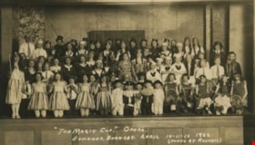
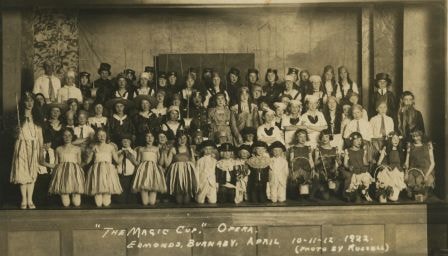
The Magic Cup Opera
https://search.heritageburnaby.ca/link/archivedescription37172
- Repository
- City of Burnaby Archives
- Date
- April 1922
- Collection/Fonds
- Burnaby Historical Society fonds
- Description Level
- Item
- Physical Description
- 1 photograph : sepia postcard ; 7.5 x 13 cm
- Scope and Content
- Photograph of the cast of The Magic Cup, an operetta performed by Edmonds School students taken in the Public Hall on the Municipal Hall grounds at 7252 Kingsway. The 5 "pages" in the front row centre are; Allan McPhee, Harold Smith, Pat Custance, Ted Fennd, Dugald Patterson. Una Patience is in the…
- Repository
- City of Burnaby Archives
- Date
- April 1922
- Collection/Fonds
- Burnaby Historical Society fonds
- Subseries
- Patterson family subseries
- Physical Description
- 1 photograph : sepia postcard ; 7.5 x 13 cm
- Description Level
- Item
- Record No.
- 326-002
- Access Restriction
- No restrictions
- Reproduction Restriction
- No known restrictions
- Accession Number
- BHS1996-11
- Scope and Content
- Photograph of the cast of The Magic Cup, an operetta performed by Edmonds School students taken in the Public Hall on the Municipal Hall grounds at 7252 Kingsway. The 5 "pages" in the front row centre are; Allan McPhee, Harold Smith, Pat Custance, Ted Fennd, Dugald Patterson. Una Patience is in the chorus. The cast practised in the "bungalow building" on school grounds.
- Names
- Carlson, Una Patience
- McPhee, Allan
- Smith, Harold
- Custance, Pat
- Fennell, Ted
- Patterson, Dugald C. Jr.
- Media Type
- Photograph
- Photographer
- Russell Photo Studio
- Notes
- Annotation at bottom of photo reads, "'The Magic Cup.' Opera / Edmonds, Burnaby, April 10-11-12 1922 / (Photo by Russell)"
- Geographic Access
- Kingsway
- Street Address
- 7252 Kingsway
- Historic Neighbourhood
- Edmonds (Historic Neighbourhood)
- Planning Study Area
- Stride Avenue Area
Images
![North Pacific Lumber Co. Barnet, B.C., [before 1929] thumbnail](/media/hpo/_Data/_Archives_Images/_Unrestricted/537/539-001.jpg?width=280)
North Pacific Lumber Co. Barnet, B.C.
https://search.heritageburnaby.ca/link/archivedescription72549
- Repository
- City of Burnaby Archives
- Date
- [before 1929]
- Collection/Fonds
- Alan Fish fonds
- Description Level
- Item
- Physical Description
- 1 photograph : sepia postcard ; 8 x 13 cm
- Scope and Content
- Photographic postcard of the North Pacific Lumber Company mill at Barnet Village in Burnaby.
- Repository
- City of Burnaby Archives
- Date
- [before 1929]
- Collection/Fonds
- Alan Fish fonds
- Physical Description
- 1 photograph : sepia postcard ; 8 x 13 cm
- Description Level
- Item
- Record No.
- 539-001
- Access Restriction
- No restrictions
- Reproduction Restriction
- No known restrictions
- Accession Number
- 2007-04
- Scope and Content
- Photographic postcard of the North Pacific Lumber Company mill at Barnet Village in Burnaby.
- Names
- Barnet Mill
- Media Type
- Photograph
- Photographer
- Timms Photographic Co.
- Notes
- Title on recto of photograph in red reads: "438. North Pacific Lumber Co. Barnet, B.C."
- Stamped in red on verso: "Timms Photographic Co., Vancouver, Canada."
- Stamped in black on verso of photograph: "Post Card / Correspondence / Name and Address / Place Postage Stamp Here"
- Note in pen on verso of photograph reads: "Alan Fish / 604 733 0459"
- Geographic Access
- Barnet Village
- Texaco Drive
- Street Address
- 8059 Texaco Drive
- Historic Neighbourhood
- Barnet (Historic Neighbourhood)
- Planning Study Area
- Burnaby Mountain Area
Images
![North Pacific Lumber Co. Barnet, B.C., [before 1929] thumbnail](/media/hpo/_Data/_Archives_Images/_Unrestricted/537/539-001.jpg)
![Power Dam, Powell River B.C., [1924] thumbnail](/media/hpo/_Data/_BVM_Images/1974/197500330003ae.jpg?width=280)
Power Dam, Powell River B.C.
https://search.heritageburnaby.ca/link/museumdescription3513
- Repository
- Burnaby Village Museum
- Date
- [1924]
- Collection/Fonds
- Burnaby Village Museum Photograph collection
- Description Level
- Item
- Physical Description
- 1 photograph : b&w postcard ; 8 x 13 cm
- Scope and Content
- Photographic postcard of the Power Dam at Powell River.
- Repository
- Burnaby Village Museum
- Collection/Fonds
- Burnaby Village Museum Photograph collection
- Description Level
- Item
- Physical Description
- 1 photograph : b&w postcard ; 8 x 13 cm
- Scope and Content
- Photographic postcard of the Power Dam at Powell River.
- History
- Bloedel Stewart and Welch built a trestle over the Campbell River in Spring 1925. BS&W acquired a timber lease on the south side of the Campbell River in order to access operations at Sayward. This is now the site of the John Hart Hydro Dam.
- Accession Code
- HV975.33.3ae
- Access Restriction
- No restrictions
- Date
- [1924]
- Media Type
- Photograph
- Scan Resolution
- 600
- Scan Date
- 2/2/2010
- Scale
- 100
- Notes
- Image from personal photograph album of Tom "Tommy" Irvine (HV975.33.3)
Images
![Power Dam, Powell River B.C., [1924] thumbnail](/media/hpo/_Data/_BVM_Images/1974/197500330003ae.jpg)
![Three women, [October 1925 or 1929] thumbnail](/media/hpo/_Data/_BVM_Images/1984/1984_0051_0050_001.jpg?width=280)
Three women
https://search.heritageburnaby.ca/link/museumdescription3020
- Repository
- Burnaby Village Museum
- Date
- [October 1925 or 1929]
- Collection/Fonds
- Burnaby Village Museum Photograph collection
- Description Level
- Item
- Physical Description
- 1 photograph : sepia postcard ; 13.2 x 8.3 cm
- Scope and Content
- Photographic postcard of three unidentified women taken in a photographic studio. The older woman is sitting on a chair in the front, and is wearing light coloured top with beads around her neck, and a long dark skirt that goes down past her calves. The two younger women who appear to be the older …
- Repository
- Burnaby Village Museum
- Collection/Fonds
- Burnaby Village Museum Photograph collection
- Description Level
- Item
- Physical Description
- 1 photograph : sepia postcard ; 13.2 x 8.3 cm
- Scope and Content
- Photographic postcard of three unidentified women taken in a photographic studio. The older woman is sitting on a chair in the front, and is wearing light coloured top with beads around her neck, and a long dark skirt that goes down past her calves. The two younger women who appear to be the older woman's daughters are in knee length dresses of polka dot patterns and mary jane shoes and are standing by the woman.
- Subjects
- Documentary Artifacts - Postcards
- Accession Code
- HV984.51.50
- Access Restriction
- No restrictions
- Reproduction Restriction
- No known restrictions
- Date
- [October 1925 or 1929]
- Media Type
- Photograph
- Scan Resolution
- 600
- Scan Date
- 2023-10-31
- Photographer
- Gale's Studios
- Notes
- Title based on contents of photograph
- Printed on the back of the postcard paper: "Gale's Studios, / Branches in all Towns."
- Stamped on the back of the photograph: "Oct 1929 [or 1925]."
Images
![Three women, [October 1925 or 1929] thumbnail](/media/hpo/_Data/_BVM_Images/1984/1984_0051_0050_001.jpg)
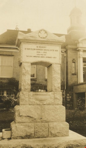
World War One Memorial
https://search.heritageburnaby.ca/link/archivedescription38506
- Repository
- City of Burnaby Archives
- Date
- 1923
- Collection/Fonds
- Burnaby Historical Society fonds
- Description Level
- Item
- Physical Description
- 1 photograph : sepia postcard ; 13.5 x 9 cm
- Scope and Content
- Photographic postcard of the World War One memorial in front of the Municipal Hall at Edmonds and Kingsway. The memorial is inscribed "In memory of our fellow workers who fell in the war 1914-1918 / Erected by the Civic Employees Union - Burnaby - 1923." In 1974, this memorial was relocated from …
- Repository
- City of Burnaby Archives
- Date
- 1923
- Collection/Fonds
- Burnaby Historical Society fonds
- Subseries
- Photographs subseries
- Physical Description
- 1 photograph : sepia postcard ; 13.5 x 9 cm
- Description Level
- Item
- Record No.
- 449-001
- Access Restriction
- No restrictions
- Reproduction Restriction
- No known restrictions
- Accession Number
- BHS2007-04
- Scope and Content
- Photographic postcard of the World War One memorial in front of the Municipal Hall at Edmonds and Kingsway. The memorial is inscribed "In memory of our fellow workers who fell in the war 1914-1918 / Erected by the Civic Employees Union - Burnaby - 1923." In 1974, this memorial was relocated from its original setting to the site of the Burnaby Village Museum on Deer Lake Avenue.
- Subjects
- Documentary Artifacts - Postcards
- Monuments - War Memorials
- Wars - World War, 1914-1918
- Fountains
- Media Type
- Photograph
- Notes
- Title based on contents of photograph.
- Geographic Access
- Kingsway
- Edmonds Street
- Street Address
- 7282 Kingsway
- 6501 Deer Lake Avenue
- Historic Neighbourhood
- Edmonds (Historic Neighbourhood)
- Planning Study Area
- Stride Avenue Area
Images

![Young woman wearing a pendant, [1923] thumbnail](/media/hpo/_Data/_BVM_Images/1984/1984_0051_0047_001.jpg?width=280)
Young woman wearing a pendant
https://search.heritageburnaby.ca/link/museumdescription265
- Repository
- Burnaby Village Museum
- Date
- [1923]
- Collection/Fonds
- Burnaby Village Museum Photograph collection
- Description Level
- Item
- Physical Description
- 1 photograph : sepia postcard ; 13.0 x 8.5 cm
- Scope and Content
- Photographic postcard of an unidentified young woman with short dark hair taken in a photographic studio. She is wearing a dress with vertical stripes, and has a pendant around her neck. There appears to be a faint outline of a face depicted in the pendant. An annotation on the back of the photogr…
- Repository
- Burnaby Village Museum
- Collection/Fonds
- Burnaby Village Museum Photograph collection
- Description Level
- Item
- Physical Description
- 1 photograph : sepia postcard ; 13.0 x 8.5 cm
- Scope and Content
- Photographic postcard of an unidentified young woman with short dark hair taken in a photographic studio. She is wearing a dress with vertical stripes, and has a pendant around her neck. There appears to be a faint outline of a face depicted in the pendant. An annotation on the back of the photograph reads: "2/23."
- Accession Code
- HV984.51.47
- Access Restriction
- No restrictions
- Reproduction Restriction
- No known restrictions
- Date
- [1923]
- Media Type
- Photograph
- Scan Resolution
- 600
- Scan Date
- 2023-10-10
- Notes
- Title based on contents of photograph
Images
![Young woman wearing a pendant, [1923] thumbnail](/media/hpo/_Data/_BVM_Images/1984/1984_0051_0047_001.jpg)

6113 Silver Avenue lot
https://search.heritageburnaby.ca/link/archivedescription37775
- Repository
- City of Burnaby Archives
- Date
- 1986 (date of original), copied 1991
- Collection/Fonds
- Burnaby Historical Society fonds
- Description Level
- Item
- Physical Description
- 1 photograph : b&w ; 3.1 x 4.4 cm print on contact sheet 20.3 x 26.2 cm
- Scope and Content
- Photograph of the lot at 6113 Silver Avenue, the former home of the Ellis family. The house has been demolished and an empty lot remains. Houses, aparment buildings, and the Expo line skytrain track with cars on it can be seen in the background.
- Repository
- City of Burnaby Archives
- Date
- 1986 (date of original), copied 1991
- Collection/Fonds
- Burnaby Historical Society fonds
- Subseries
- Burnaby Image Bank subseries
- Physical Description
- 1 photograph : b&w ; 3.1 x 4.4 cm print on contact sheet 20.3 x 26.2 cm
- Description Level
- Item
- Record No.
- 370-363
- Access Restriction
- No restrictions
- Reproduction Restriction
- No restrictions
- Accession Number
- BHS1999-03
- Scope and Content
- Photograph of the lot at 6113 Silver Avenue, the former home of the Ellis family. The house has been demolished and an empty lot remains. Houses, aparment buildings, and the Expo line skytrain track with cars on it can be seen in the background.
- Subjects
- Land Clearing
- Media Type
- Photograph
- Notes
- Title based on contents of photograph
- 1 b&w copy negative accompanying
- Negative has a pink cast
- Copied from col. photograph
- Geographic Access
- Silver Avenue
- Street Address
- 6113 Silver Avenue
- Historic Neighbourhood
- Central Park (Historic Neighbourhood)
- Planning Study Area
- Maywood Area
Images
