Narrow Results By
Person / Organization
- British Columbia Hydro and Power Authority 1
- Burnaby Central Secondary School 18
- Burnaby Lake Nature House 4
- Burnaby Lake Rowing Pavilion 1
- Burnaby School Trustees 4
- Burnaby Village Museum 2
- Ceperley, H.T. 2
- Chalk, John 4
- Chalk, Timothy 4
- City of Burnaby 1
- Gaglardi, Philip A. "Flyin' Phil" 1
- G.F. and J. Galt Limited 1
Aerial photograph of Burnaby Lake Area
https://search.heritageburnaby.ca/link/archivedescription84908
- Repository
- City of Burnaby Archives
- Date
- 1963
- Collection/Fonds
- Allan Amundsen collection
- Description Level
- Item
- Physical Description
- 1 photograph : b&w ; 22.5 x 22.5 cm
- Scope and Content
- Aerial photograph of Burnaby with Lougheed Highway in the north west corner, the Trans Canada Highway in the south east corner and Burnaby Lake appearing from the west.
- Repository
- City of Burnaby Archives
- Date
- 1963
- Collection/Fonds
- Allan Amundsen collection
- Physical Description
- 1 photograph : b&w ; 22.5 x 22.5 cm
- Description Level
- Item
- Record No.
- 561-026
- Access Restriction
- In Archives only
- Reproduction Restriction
- No reproduction permitted
- Accession Number
- 2014-08
- Scope and Content
- Aerial photograph of Burnaby with Lougheed Highway in the north west corner, the Trans Canada Highway in the south east corner and Burnaby Lake appearing from the west.
- Subjects
- Aerial Photographs
- Media Type
- Photograph
- Photographer
- Province of British Columbia
- Notes
- Title based on contents of photograph
- This photo is indentified as BC5062:25 and connects with B.C. air photograph BC5062:26 to the west and B.C. air photograph BC5062:24 to the east
- Historic Neighbourhood
- Burnaby Lake (Historic Neighbourhood)
- Lozells (Historic Neighbourhood)
- Planning Study Area
- Douglas-Gilpin Area
- Sperling-Broadway Area
- Government Road Area
- Burnaby Lake Area
Aerial photograph of Burnaby Lake Area
https://search.heritageburnaby.ca/link/archivedescription84909
- Repository
- City of Burnaby Archives
- Date
- 1963
- Collection/Fonds
- Allan Amundsen collection
- Description Level
- Item
- Physical Description
- 1 photograph : b&w ; 22.5 x 22.5 cm
- Scope and Content
- Aerial photograph of Burnaby with Lougheed Highway to the north and Burnaby Lake to the south.
- Repository
- City of Burnaby Archives
- Date
- 1963
- Collection/Fonds
- Allan Amundsen collection
- Physical Description
- 1 photograph : b&w ; 22.5 x 22.5 cm
- Description Level
- Item
- Record No.
- 561-027
- Access Restriction
- In Archives only
- Reproduction Restriction
- No reproduction permitted
- Accession Number
- 2014-08
- Scope and Content
- Aerial photograph of Burnaby with Lougheed Highway to the north and Burnaby Lake to the south.
- Subjects
- Aerial Photographs
- Media Type
- Photograph
- Photographer
- Province of British Columbia
- Notes
- Title based on contents of photograph
- This photo is indentified as BC5062:24 and connects with B.C. air photograph BC5062:25 to the west and B.C. air photograph BC5062:23 to the east
- Historic Neighbourhood
- Burnaby Lake (Historic Neighbourhood)
- Lozells (Historic Neighbourhood)
- Planning Study Area
- Douglas-Gilpin Area
- Sperling-Broadway Area
- Government Road Area
- Burnaby Lake Area
Aerial photograph of Burnaby Lake Area
https://search.heritageburnaby.ca/link/archivedescription84910
- Repository
- City of Burnaby Archives
- Date
- 1963
- Collection/Fonds
- Allan Amundsen collection
- Description Level
- Item
- Physical Description
- 1 photograph : b&w ; 22.5 x 22.5 cm
- Scope and Content
- Aerial photograph of Burnaby with Burnaby Lake to the south and Broadway to the north.
- Repository
- City of Burnaby Archives
- Date
- 1963
- Collection/Fonds
- Allan Amundsen collection
- Physical Description
- 1 photograph : b&w ; 22.5 x 22.5 cm
- Description Level
- Item
- Record No.
- 561-028
- Access Restriction
- In Archives only
- Reproduction Restriction
- No reproduction permitted
- Accession Number
- 2014-08
- Scope and Content
- Aerial photograph of Burnaby with Burnaby Lake to the south and Broadway to the north.
- Subjects
- Aerial Photographs
- Media Type
- Photograph
- Photographer
- Province of British Columbia
- Notes
- Title based on contents of photograph
- This photo is indentified as BC5062:23 and connects with B.C. air photograph BC5062:24 to the west and B.C. air photograph BC5062:22 to the east
- Historic Neighbourhood
- Burnaby Lake (Historic Neighbourhood)
- Lozells (Historic Neighbourhood)
- Planning Study Area
- Lake City Area
- Government Road Area
- Burnaby Lake Area
Allocation of Land in the Burnaby Lake Area Between the Greater Vancouver Regional District and the Municipality
https://search.heritageburnaby.ca/link/councilreport29716
- Repository
- City of Burnaby Archives
- Report ID
- 22150
- Meeting Date
- 20-Mar-1972
- Format
- Council - Committee Report
- Collection/Fonds
- City Council and Office of the City Clerk fonds
- Repository
- City of Burnaby Archives
- Report ID
- 22150
- Meeting Date
- 20-Mar-1972
- Format
- Council - Committee Report
- Collection/Fonds
- City Council and Office of the City Clerk fonds
Documents

Bird's Eye View of the Burnaby Lake Area
https://search.heritageburnaby.ca/link/museumdescription15144
- Repository
- Burnaby Village Museum
- Date
- 1977
- Collection/Fonds
- Century Park Museum Association fonds
- Description Level
- Item
- Physical Description
- 1 map : b&w print on paper ; 43 x 63.5 cm
- Scope and Content
- Item consists of a map titled "Birds Eye View of the Burnaby Lake Area Circa 1910". The overview of the Burnaby Lake area was compiled and drawn at Heritage Village by curator John Adams and artist, Carol Swan. The map identifies the Burnaby Lake inter-urban tram line; roads including: Sperling Ave…
- Repository
- Burnaby Village Museum
- Collection/Fonds
- Century Park Museum Association fonds
- Description Level
- Item
- Physical Description
- 1 map : b&w print on paper ; 43 x 63.5 cm
- Material Details
- Scale indeterminable
- Scope and Content
- Item consists of a map titled "Birds Eye View of the Burnaby Lake Area Circa 1910". The overview of the Burnaby Lake area was compiled and drawn at Heritage Village by curator John Adams and artist, Carol Swan. The map identifies the Burnaby Lake inter-urban tram line; roads including: Sperling Avenue (Pole Line Road); Gilpin Avenue; Douglas Road; trail to Vancouver Westminster Road (Kingsway); Buckingham Avenue; Haszard Street; various farms and residences including: Charles Sprott "Norland"; H.T. Ceperley "Fairacres"; Claude Hill's "Brookfield farm" and "Broadview"; F.J. Hart's "Avalon"; Miss Woodward's former and new home, school and post office; Councillor Edgar's hunting cabin; Edgar Sprott's "Mayfield farm" and "Mayfield Lodge"; F.J. Peers "Greyfriars"; Arthur de Windt Haszard; Bernard Hill's boathouse as well as other landmarks including: Doran's Mill; tram stations; Burnaby Lake Store; logging camps; wood cutter's shacks; ice houses; cranberry bog; Still Creek; Deer Lake; Burnaby Lake; Deer Lake Creek; Provincial Government Reserve Proposed Hospital (later Oakalla Prison).
- Creator
- Adams, John
- Swan, Carol
- Names
- Hill, Arthur Claude
- Sprott, Charles Frederick
- Sprott, Louis "Edgar"
- Hart, Frederick John, 1884-1945
- Ceperley, H.T.
- Woodward, Maude
- Woodward, Harriet
- Peers, Francis J.
- Haszard, Arthur de Windt
- Hill, Bernard R.
- Geographic Access
- Deer Lake Avenue
- Sperling Avenue
- Haszard Street
- Buckingham Avenue
- Accession Code
- BV021.1.3
- Access Restriction
- No restrictions
- Reproduction Restriction
- No known restrictions
- Date
- 1977
- Media Type
- Cartographic Material
- Historic Neighbourhood
- Burnaby Lake (Historic Neighbourhood)
- Planning Study Area
- Burnaby Lake Area
- Related Material
- See also: Life with the Moores of Hart House : pioneer days on Burnaby's Deer Lake
- Scan Resolution
- 600
- Scan Date
- 2021-11-12
- Scale
- 100
- Notes
- Transcribed title
- Compiled by John Adams; illustration by Carol Swan
- The map depicts the Burnaby Lake Tram Line as being double tracked, whereas in reality it was single tracked.
- Map is part of the book "Life with the Moores of Hart House : pioneer days on Burnaby's Deer Lake https://search.heritageburnaby.ca/permalink/museumlibrary6314-102
Images


Bird's Eye View of the Burnaby Lake Area
https://search.heritageburnaby.ca/link/museumdescription17543
- Repository
- Burnaby Village Museum
- Date
- 1977
- Collection/Fonds
- Century Park Museum Association fonds
- Description Level
- Item
- Physical Description
- 1 map : b&w print with watercolour ; 43 x 63.5 cm
- Scope and Content
- Item consists of a map titled "Birds Eye View of the Burnaby Lake Area Circa 1910". The overview of the Burnaby Lake area was compiled and drawn at Heritage Village by curator John Adams and artist, Carol Swan. The map identifies the Burnaby Lake inter-urban tram line; roads including: Sperling Ave…
- Repository
- Burnaby Village Museum
- Collection/Fonds
- Century Park Museum Association fonds
- Description Level
- Item
- Physical Description
- 1 map : b&w print with watercolour ; 43 x 63.5 cm
- Material Details
- Scale indeterminable
- Scope and Content
- Item consists of a map titled "Birds Eye View of the Burnaby Lake Area Circa 1910". The overview of the Burnaby Lake area was compiled and drawn at Heritage Village by curator John Adams and artist, Carol Swan. The map identifies the Burnaby Lake inter-urban tram line; roads including: Sperling Avenue (Pole Line Road); Gilpin Avenue; Douglas Road; trail to Vancouver Westminster Road (Kingsway); Buckingham Avenue; Haszard Street; various farms and residences including: Charles Sprott "Norland"; H.T. Ceperley "Fairacres"; Claude Hill's "Brookfield farm" and "Broadview"; F.J. Hart's "Avalon"; Miss Woodward's former and new home, school and post office; Councillor Edgar's hunting cabin; Edgar Sprott's "Mayfield farm" and "Mayfield Lodge"; F.J. Peers "Greyfriars"; Arthur de Windt Haszard; Bernard Hill's boathouse as well as other landmarks including: Doran's Mill; tram stations; Burnaby Lake Store; logging camps; wood cutter's shacks; ice houses; cranberry bog; Still Creek; Deer Lake; Burnaby Lake; Deer Lake Creek; Provincial Government Reserve Proposed Hospital (later Oakalla Prison).
- Creator
- Adams, John
- Swan, Carol
- Names
- Hill, Arthur Claude
- Sprott, Charles Frederick
- Sprott, Louis "Edgar"
- Hart, Frederick John, 1884-1945
- Ceperley, H.T.
- Woodward, Maude
- Woodward, Harriet
- Peers, Francis J.
- Haszard, Arthur de Windt
- Hill, Bernard R.
- Geographic Access
- Deer Lake Avenue
- Sperling Avenue
- Haszard Street
- Buckingham Avenue
- Accession Code
- BV021.1.4
- Access Restriction
- No restrictions
- Reproduction Restriction
- No known restrictions
- Date
- 1977
- Media Type
- Cartographic Material
- Historic Neighbourhood
- Burnaby Lake (Historic Neighbourhood)
- Planning Study Area
- Burnaby Lake Area
- Related Material
- See also: Life with the Moores of Hart House : pioneer days on Burnaby's Deer Lake
- Scan Resolution
- 600
- Scan Date
- 2021-11-12
- Scale
- 100
- Notes
- Transcribed title
- Compiled by John Adams; illustration by Carol Swan
- The map depicts the Burnaby Lake Tram Line as being double tracked, whereas in reality it was single tracked.
- Map is part of the book "Life with the Moores of Hart House : pioneer days on Burnaby's Deer Lake https://search.heritageburnaby.ca/permalink/museumlibrary6314-102
- This is a print made from original illustration and appears to be hand-coloured with watercolour at a later date.
Images

Installation of Mail Collection Boxes in Burnaby Lake Area
https://search.heritageburnaby.ca/link/councilreport66095
- Repository
- City of Burnaby Archives
- Report ID
- 58301
- Meeting Date
- 7-Jun-1926
- Format
- Council - Mayor/Councillor/Staff Report
- Collection/Fonds
- City Council and Office of the City Clerk fonds
- Repository
- City of Burnaby Archives
- Report ID
- 58301
- Meeting Date
- 7-Jun-1926
- Format
- Council - Mayor/Councillor/Staff Report
- Collection/Fonds
- City Council and Office of the City Clerk fonds
Documents
Nature Trails - Burnaby Lake Area (Burnaby Outdoor Education Association)
https://search.heritageburnaby.ca/link/councilreport28464
- Repository
- City of Burnaby Archives
- Report ID
- 20802
- Meeting Date
- 26-Mar-1973
- Format
- Council - Manager's Report
- Manager's Report No.
- 23
- Item No.
- 17
- Collection/Fonds
- City Council and Office of the City Clerk fonds
- Repository
- City of Burnaby Archives
- Report ID
- 20802
- Meeting Date
- 26-Mar-1973
- Format
- Council - Manager's Report
- Manager's Report No.
- 23
- Item No.
- 17
- Collection/Fonds
- City Council and Office of the City Clerk fonds
Documents
New 60 KV Electrical Supply Line - Government Road/Burnaby Lake Area (Bingham-Williamette Ltd.)
https://search.heritageburnaby.ca/link/councilreport25731
- Repository
- City of Burnaby Archives
- Report ID
- 18112
- Meeting Date
- 17-Mar-1975
- Format
- Council - Manager's Report
- Manager's Report No.
- 19
- Item No.
- 3
- Collection/Fonds
- City Council and Office of the City Clerk fonds
- Repository
- City of Burnaby Archives
- Report ID
- 18112
- Meeting Date
- 17-Mar-1975
- Format
- Council - Manager's Report
- Manager's Report No.
- 19
- Item No.
- 3
- Collection/Fonds
- City Council and Office of the City Clerk fonds
Documents
New 69 KV Electrical Supply Line Government Road/Burnaby Lake Area
https://search.heritageburnaby.ca/link/councilreport26819
- Repository
- City of Burnaby Archives
- Report ID
- 19629
- Meeting Date
- 21-May-1974
- Format
- Council - Manager's Report
- Manager's Report No.
- 39
- Item No.
- 21
- Collection/Fonds
- City Council and Office of the City Clerk fonds
- Repository
- City of Burnaby Archives
- Report ID
- 19629
- Meeting Date
- 21-May-1974
- Format
- Council - Manager's Report
- Manager's Report No.
- 39
- Item No.
- 21
- Collection/Fonds
- City Council and Office of the City Clerk fonds
Documents
Offer from Pacific Airways Limited re Creation of Report on the Suitability or Otherwise of the Burnaby Lake Area as an Airport
https://search.heritageburnaby.ca/link/councilreport66243
- Repository
- City of Burnaby Archives
- Report ID
- 57291
- Meeting Date
- 5-Mar-1928
- Format
- Council - Mayor/Councillor/Staff Report
- Collection/Fonds
- City Council and Office of the City Clerk fonds
- Repository
- City of Burnaby Archives
- Report ID
- 57291
- Meeting Date
- 5-Mar-1928
- Format
- Council - Mayor/Councillor/Staff Report
- Collection/Fonds
- City Council and Office of the City Clerk fonds
Documents

Burnaby Lake Neighbourhood
https://search.heritageburnaby.ca/link/landmark700
- Repository
- Burnaby Heritage Planning
- Associated Dates
- 1925-1954
- Heritage Value
- After World War I and the Great Depression of the 1930s, more homes were constructed and subdivisions created in the Burnaby Lake district. The area around Deer Lake gained a reputation for being an "artistic development of commodious homes with park-like grounds."
- Historic Neighbourhood
- Burnaby Lake (Historic Neighbourhood)
- Planning Study Area
- Burnaby Lake Area
Images


Burnaby Lake Neighbourhood
https://search.heritageburnaby.ca/link/landmark821
- Repository
- Burnaby Heritage Planning
- Associated Dates
- 1955-2008
- Heritage Value
- In 1966 Burnaby Lake was identified as a key potential regional park in the GVRD ’s Regional Park Plan for the Lower Mainland. The lake was to be developed for nature study, strolling, trail riding, canoeing, sightseeing and picnicking. It was formally recognized as a regional nature park in 1979, at which time the GVRD assumed management of the park through a lease agreement with the City of Burnaby. In 1993 Burnaby Lake was selected by the City of Burnaby to be included in Greater Vancouver ’s Green Zone, and was identified as a key component of the GVRD ’s Park and Outdoor Recreation System (PORS) for the Burrard/Peninsula/Richmond sector, which includes Burnaby, Vancouver, New Westminster, and Richmond.
- Historic Neighbourhood
- Burnaby Lake (Historic Neighbourhood)
- Planning Study Area
- Burnaby Lake Area
Images


Mortimer-Lamb House
https://search.heritageburnaby.ca/link/landmark494
- Repository
- Burnaby Heritage Planning
- Description
- The Mortimer-Lamb House is a one and one half-storey, Arts and Crafts-style residence with a steeply pitched, side-gabled roof. The original cottage form has been enlarged with a later addition on the west side of the house. Located next to the Burnaby Lake Regional Park Wildlife Rescue Care Centre…
- Associated Dates
- c.1922
- Formal Recognition
- Community Heritage Register
- Other Names
- Harold & Katherine Mortimer-Lamb Residence
- Street View URL
- Google Maps Street View
- Repository
- Burnaby Heritage Planning
- Other Names
- Harold & Katherine Mortimer-Lamb Residence
- Geographic Access
- Glencarin Drive
- Associated Dates
- c.1922
- Formal Recognition
- Community Heritage Register
- Enactment Type
- Council Resolution
- Enactment Date
- 26/05/2003
- Description
- The Mortimer-Lamb House is a one and one half-storey, Arts and Crafts-style residence with a steeply pitched, side-gabled roof. The original cottage form has been enlarged with a later addition on the west side of the house. Located next to the Burnaby Lake Regional Park Wildlife Rescue Care Centre, the house has picturesque views of Burnaby Lake.
- Heritage Value
- Built circa 1922, the Mortimer-Lamb House is valued for its association with first owners, Harold Mortimer-Lamb (1872-1970), and his wife, Katherine Mary Mortimer-Lamb (1873-1939). Born in Leatherhead, Surrey, England, Harold Mortimer-Lamb immigrated to Canada in 1889. Seven years later in Vancouver, he married Katherine Mary Lindsay, a native of Winnipeg. Mortimer-Lamb was a key figure in the B.C. mining industry, serving as Secretary of the Mining Association of B.C. between 1900 and 1945, and also as the Secretary of the Canadian Institute of Mining and Metallurgy. In addition to his professional life, Mortimer-Lamb was a pioneer art photographer and was among Canada's leading art critics, and this house served as a central gathering place for renowned Canadian artists of the day. Mortimer-Lamb’s daughter, Molly Lamb Bobak (born 1922), became a renowned watercolourist, and was the only woman ever hired as an official Canadian war artist. The Mortimer-Lamb House is a significant example of the work of noted architect, Samuel Maclure (1860-1929) and his partner, Ross Lort (1889-1969). Maclure, who was a close friend of the Mortimer-Lamb family, was British Columbia's leading residential architect, and was renowned for his high quality designs for prominent citizens in both Vancouver and Victoria. Maclure was a leading exponent of the Art and Crafts design movement in B.C., and established a sophisticated local variation of residential architecture. The Mortimer-Lamb House was designed at the time when Maclure was in partnership with Ross Lort. In 1907, Lort began working for Maclure's firm as a draftsman, and by 1920 was in charge of Maclure's Vancouver office. Lort's architectural career spanned some sixty-years, and he designed some of the province's most familiar houses, apartments, institutions and places of worship. The Mortimer-Lamb House is also a significant local example of the Arts and Crafts style, and incorporates elements such as board-and-batten siding on the ground floor, shingled gables and leaded casement windows. It is a testament to the domestic architecture built outside of established suburbs during the post-First World War era, typically modest in scale and representative of middle-class residential ideals.
- Defining Elements
- Key elements that define the heritage character of the Mortimer-Lamb House include its: - treed setting with views of Burnaby Lake - residential form, scale and massing as expressed by its one and one-half storey height, rectangular plan and steeply pitched side-gabled roof - wood-frame construction - Arts and Crafts elements such as board-and-batten siding on the ground floor, cedar shingles in the gables and open soffits - original straight-leaded casement windows in single and multiple-assembly - internal red-brick chimney with corbelled cap
- Historic Neighbourhood
- Burnaby Lake (Historic Neighbourhood)
- Planning Study Area
- Burnaby Lake Area
- Organization
- Mining Association of B.C.
- G.F. and J. Galt Limited
- Architect
- Samuel Maclure
- Ross Lort
- Function
- Primary Historic--Single Dwelling
- Primary Current--Single Dwelling
- Community
- Burnaby Lake
- Cadastral Identifier
- P.I.D.002-977-788
- Boundaries
- The Mortimer-Lamb House is comprised of a single residential lot located at 5180 Glencairn Drive, Burnaby.
- Area
- 5652.78
- Contributing Resource
- Building
- Ownership
- Private
- Documentation
- City of Burnaby Planning and Building Department, Heritage Site Files
- Street Address
- 5180 Glencarin Drive
- Street View URL
- Google Maps Street View
Images


Stanley & Isabel Picken House 'Aintree'
https://search.heritageburnaby.ca/link/landmark519
- Repository
- Burnaby Heritage Planning
- Description
- Nestled within a stand of deciduous trees, the Stanley and Isabel Picken House 'Aintree' is a two and one-half storey plus basement shingled and half-timbered Arts and Crafts influenced residence, set on its original 0.6 hectare site adjacent to Brunette Creek in the Burnaby Lake Regional Nature Pa…
- Associated Dates
- 1929
- Formal Recognition
- Heritage Designation, Community Heritage Register
- Street View URL
- Google Maps Street View
- Repository
- Burnaby Heritage Planning
- Geographic Access
- Cariboo Road
- Associated Dates
- 1929
- Formal Recognition
- Heritage Designation, Community Heritage Register
- Enactment Type
- Bylaw No. 11756
- Enactment Date
- 09/08//2004
- Description
- Nestled within a stand of deciduous trees, the Stanley and Isabel Picken House 'Aintree' is a two and one-half storey plus basement shingled and half-timbered Arts and Crafts influenced residence, set on its original 0.6 hectare site adjacent to Brunette Creek in the Burnaby Lake Regional Nature Park.
- Heritage Value
- 'Aintree' is an example of the type of private country estate residences built in Burnaby outside of the established suburbs during the 1920s, and is representative of middle-class residential life during this time. Stanley Boyd Picken (1890-1950) and Isabel Grace Frederique Picken (1893-1971) purchased this property in 1927 to establish the Aintree Dog Kennels, which was the first in the province to breed Irish Setters. This country residence was completed in 1929. Stanley Picken worked at a variety of other jobs including his position as keeper of the Brunette River Caribou Dam. Considered a fine example of romantic architecture, 'Aintree' stands in harmony with its woodland setting. The north wing was added in a compatible style in 1932 using former bridge support beams from the old Caribou Road Bridge for foundation support. 'Aintree' retains most of its original exterior elements including its picturesque shingled siding and half-timbering, demonstrating the late influence of an Arts and Crafts sensibility considered compatible with a country lifestyle.
- Defining Elements
- Key elements that define the heritage character of 'Aintree' include its: - woodland setting adjacent to Brunette Creek in the Burnaby Lake Regional Nature Park, with a deep setback from Cariboo Road - residential form, scale and massing as exemplified by its asymmetrical two and one-half storey plus basement height and irregular U-shaped plan - romantic Arts and Crafts influence as expressed in elements such as half-timbering on the upper storeys and hand-split cedar shake wall cladding - steeply pitched cross-gabled roofs with dormers connected by a lower central gabled roof, and 'cat slide' extension over side entry - regular fenestration, including wooden-sash casement windows with diamond leaded glass - red brick internal chimney with corbelled cap - associated landscape features, such as a curving driveway leading to the house, an early garage, grassed yard and a backdrop of mature deciduous trees
- Historic Neighbourhood
- Burquitlam (Historic Neighbourhood)
- Planning Study Area
- Burnaby Lake Area
- Function
- Primary Historic--Single Dwelling
- Community
- Burnaby
- Cadastral Identifier
- 010-867-147
- Boundaries
- 'Aintree' is comprised of a single residential lot located at 6825 Cariboo Road, Burnaby.
- Area
- 5436.75
- Contributing Resource
- Building
- Ownership
- Private
- Names
- Picken, Stanley
- Street Address
- 6825 Cariboo Road
- Street View URL
- Google Maps Street View
Images


Pioneer tales of Burnaby
https://search.heritageburnaby.ca/link/museumlibrary5860
- Repository
- Burnaby Village Museum
- Collection
- Digital Reference Collection
- Reference Collection
- Material Type
- Book
- ISBN
- 096928280x
- Call Number
- 971.133 SON COPY 4
- Contributor
- Sone, Michael
- Place of Publication
- Burnaby, B.C.
- Publisher
- Corporation of the District of Burnaby
- Publication Date
- c1987
- Physical Description
- 495 p. : ill. ; 31 cm.
- Inscription
- "TR687 - Bryburgh" / handprinted in pencil on frontend page
- Library Subject (LOC)
- Pioneers--British Columbia--Burnaby
- Frontier and pioneer life
- Biography
- Object History
- Early Burnaby as recalled by the settlers themselves who arrived from every corner of the world between 1888 and 1930, some witnessing incorporation of the district in 1892, all seeking a better life for themselves and especially for their children, all helping transform the wilderness into the modern municipality of today.
- Notes
- "Editor Michael Sone".
- Includes index.
- 4 copies held: copy 4
Images

Digital Books
Peers Family and Hill Family fonds
https://search.heritageburnaby.ca/link/archivedescription98
- Repository
- City of Burnaby Archives
- Date
- [1880-1980]
- Collection/Fonds
- Peers Family and Hill Family fonds
- Description Level
- Fonds
- Physical Description
- ca. 1200 photographs and other material
- Scope and Content
- Fonds consists of records, primarily photographs, compiled by various members of both the Hill and Peers families that document their lives during the early days of settlement in Burnaby. The fonds includes records of citizenship, wills and other official papers pertaining to the life and activitie…
- Repository
- City of Burnaby Archives
- Date
- [1880-1980]
- Collection/Fonds
- Peers Family and Hill Family fonds
- Physical Description
- ca. 1200 photographs and other material
- Description Level
- Fonds
- Access Restriction
- No restrictions
- Accession Number
- 2007-12
- Scope and Content
- Fonds consists of records, primarily photographs, compiled by various members of both the Hill and Peers families that document their lives during the early days of settlement in Burnaby. The fonds includes records of citizenship, wills and other official papers pertaining to the life and activities of L. Claude Hill; photographs of the Peers family’s Burnaby Lake home, Greyfriars, and pictures taken by Arthur Peers during his work and travels throughout British Columbia in the first part of the 20th century; and photographs of the family of Claude Hill, early Burnaby Lake residents and scenes, and pictures Kitty took as an adult documenting the growth of her own family. Also included in this fonds are a number of photographs showing Yellow Point, Vancouver Island, where the Peers and Hill families often vacationed.
- History
- Bob Peers was born William John Peers, the son of real estate broker and early Burnaby resident, Francis John Peers and his wife Elizabeth Frisby. Originally from England, the family moved to Vancouver in 1905 and soon after settled at Burnaby Lake. The family included one daughter (Mary Elizabeth Dora) and four boys (Arthur Francis, William John “Bob”, Geoffrey Hugh, and Richard Dominic). When they arrived in Burnaby, Francis Peers purchased a piece of land from another early settler, Claude Hill, and built the family home “Greyfriars” near Deer Lake. The children attended school in the home of Miss Harriet Woodward, the first school to be held in the Burnaby Lake area. In 1925, Bob married Claude Hill’s daughter and another former pupil of “Miss Harry’s,” Kitty Hill. Kitty (born Katherine Maude Hill) was the only child of Burnaby pioneers L. Claude Hill and Annie Sara Kenrick. Having moved to the Burnaby Lake area in the early 1890s, Claude went on to operate a successful strawberry farm and soon became active in the political development of Burnaby – being elected to the first Burnaby Council and serving from 1892-1894 and again from 1909-1910. The first Hill family home, “Brookfield,” was sold around 1907 and the family moved to their new home, “Broadview,” which was also built in the vicinity of Deer Lake. In 1925, Bob and Kitty were married and they went on to have three children, Robert C.K., Barbara (later Barbara Jeffrey), and Anne (later Anne Latham).
- Formats
- All photographic records have been scanned and are saved in jpeg format on the City of Burnaby network. Archival master copies have also been produced in tiff format and have been burned to CD for preservation purposes.
- Media Type
- Textual Record
- Photograph
- Creator
- Peers family
- Hill family
- Notes
- Title based on contents of fonds
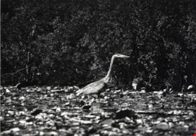
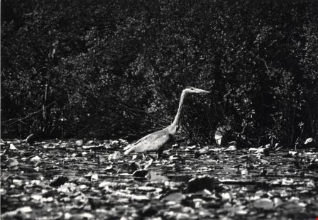
Blue Heron
https://search.heritageburnaby.ca/link/archivedescription79878
- Repository
- City of Burnaby Archives
- Date
- September, 1976
- Collection/Fonds
- Burnaby Public Library Contemporary Visual Archive Project
- Description Level
- Item
- Physical Description
- 1 photograph : b&w ; 11 x 16 cm mounted on cardboard
- Scope and Content
- Photograph shows a blue heron near the shore of Burnaby Lake - one of the more than 180 species of bird and animal life that have been identified in the Burnaby Lake area.
- Repository
- City of Burnaby Archives
- Date
- September, 1976
- Collection/Fonds
- Burnaby Public Library Contemporary Visual Archive Project
- Physical Description
- 1 photograph : b&w ; 11 x 16 cm mounted on cardboard
- Description Level
- Item
- Record No.
- 556-480
- Access Restriction
- No restrictions
- Reproduction Restriction
- Reproduce for fair dealing purposes only
- Accession Number
- 2013-13
- Scope and Content
- Photograph shows a blue heron near the shore of Burnaby Lake - one of the more than 180 species of bird and animal life that have been identified in the Burnaby Lake area.
- Subjects
- Animals - Birds
- Media Type
- Photograph
- Photographer
- Salmon, Stu
- Notes
- Scope note taken directly from BPL photograph description.
- 1 b&w copy negative : 10 x 12.5 cm accompanying
- Geographic Access
- Burnaby Lake
- Historic Neighbourhood
- Burnaby Lake (Historic Neighbourhood)
Images

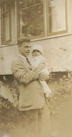
Bob and Robert Peers at Burnaby Lake
https://search.heritageburnaby.ca/link/archivedescription38940
- Repository
- City of Burnaby Archives
- Date
- 1927
- Collection/Fonds
- Peers Family and Hill Family fonds
- Description Level
- Item
- Physical Description
- 1 photograph : sepia ; 6 x 10.5 cm on page 13.5 x 18.5 cm (pasted in album)
- Scope and Content
- Photograph of Bob Peers and his son, Robert outside a home identified by a caption as being at "Burnaby Lake." This likely refers to the Bob and Kitty Peers home in the Burnaby Lake area, on Deer Lake Avenue.
- Repository
- City of Burnaby Archives
- Date
- 1927
- Collection/Fonds
- Peers Family and Hill Family fonds
- Physical Description
- 1 photograph : sepia ; 6 x 10.5 cm on page 13.5 x 18.5 cm (pasted in album)
- Description Level
- Item
- Record No.
- 477-259
- Access Restriction
- No restrictions
- Reproduction Restriction
- No known restrictions
- Accession Number
- 2007-12
- Scope and Content
- Photograph of Bob Peers and his son, Robert outside a home identified by a caption as being at "Burnaby Lake." This likely refers to the Bob and Kitty Peers home in the Burnaby Lake area, on Deer Lake Avenue.
- Media Type
- Photograph
- Notes
- Title based on caption accompanying photograph
- Geographic Access
- Deer Lake Avenue
- Street Address
- 6588 Deer Lake Avenue
- Historic Neighbourhood
- Burnaby Lake (Historic Neighbourhood)
- Planning Study Area
- Douglas-Gilpin Area
Images
Burnaby - Images of Change - slide presentation
https://search.heritageburnaby.ca/link/museumdescription13116
- Repository
- Burnaby Village Museum
- Date
- February 1978 (date of slide show)
- Collection/Fonds
- Century Park Museum Association fonds
- Description Level
- File
- Physical Description
- 52 photographs : col. slides ; 35 mm
- Scope and Content
- File consists of fifty two slides used for a Hertiage Village Museum presentation titled "Burnaby - Images of Change". The slides were part of a resource kit prepared by "Heritage Village Education" and consist of copies of historical photographs taken between 1891 and 1931. Numbered slides includ…
- Repository
- Burnaby Village Museum
- Collection/Fonds
- Century Park Museum Association fonds
- Description Level
- File
- Physical Description
- 52 photographs : col. slides ; 35 mm
- Scope and Content
- File consists of fifty two slides used for a Hertiage Village Museum presentation titled "Burnaby - Images of Change". The slides were part of a resource kit prepared by "Heritage Village Education" and consist of copies of historical photographs taken between 1891 and 1931. Numbered slides include; "1) Title slide; 2) Mr. and Mrs. S. Shepard Samuel, 1904; 3) The McMurray Family 1907; 4) The Bateman Family; 5) Mr. Alexis Shaw; 6) Dr. R. Ellen Walker; 7) Home of Col. J. Ward on the north side of Burnaby Lake; 8) Cameron home located on New Westminster Road - now Kingsway; 9) Home of L.C. Hill, "Brookfield" 1894; 10) Bernard Hill's home on Burnaby Lake, 1910; 11) Bateman Family residence under construction, 1920; 12) Bateman residence known as "Elworth House" completed in 1922; 13) Early logging operaton in 1890 using oxen and a skid road; 14) Steam donkey and loggers; 15) Cord wood delivery in 1925; 16) L.C. Hill's strawberry farm in 1895; 17) Strawberries being delivered to New Westminster in 1896; 18) Haying operation on Douglas Road in 1906; 19) 1906 haying scene in the Burnaby Lake area; 20) Kingsway store of Mr. C.B. Button, 1904; 21) Model Grocery stroe at Hastings and Sperling in 1920; 22) Dow Grocery store at Hastings and Sperling in 1920; 23) Zebulon Frank's hardware store in 1887 - Vancouver; 24) Inside of a phography shop, 1910- Vancouver; Burnaby's first Municipal Council, 1892; 25) Burnaby's first Municipal Hall opened in 1899; 27) Presbyterian Church in Westminster Road at Central Park, 1896; 28) St. John the Devine Church in 1896; 29) First school in Burnaby near Edmonds and Douglas Road; 30) School Children, 1904; 31) Miss Harriett Woodward's private school near Deer Lake, 1907; 32) Gilmore Avenue School, March 17, 1920; 33) Pupils of Edmonds Street School, 1922; 34) L.C. Hill Family picnic in July 1892; 35) Lewis Family picnic in 1910; 36) Catch of fish from Deer Lake, 1910; 37) Hunting scene in Burnaby area, 1910; 38) Burnaby's first lawn bowling green, 1907; 39) Skating on Deer Lake, 1912; 40) Skating party on Deer Lake in the winter of 1921; 41) Boating on Deer Lake, 1922; 42) Burnaby's first May Day celebration in 1925; 43) May Day, 1926; 44) Westminster to Vancouver Tram, 1892; 45) Interurban powerhouse at Edmonds and Highland Park, 1891; 46) Douglas Road, 1895; 47) Horse team hauling crushed rock for Douglas Road, 1911; 48) Horse and cart passing cleared land; 49) Cyclist, 1912; 50) The Opening of the paved road (Kingsway), 1913; 51) Painting the white line on Kingsway, 1928; 52) First auto in Burnaby circa 1905; 53) Alfred Bingham and his model T. Ford, 1931".
- Creator
- Burnaby Village Museum
- Names
- Burnaby Village Museum
- Accession Code
- BV020.5.734
- Access Restriction
- No restrictions
- Reproduction Restriction
- No known restrictions
- Date
- February 1978 (date of slide show)
- Media Type
- Photograph
- Notes
- Title based on contents of file
- Original photograph content ranges between 1891 and 1931.
- Description of slides taken from "Slide indentification" list BV020.5.735
- See also audio recording commentary BV020.5.733