More like 'Bob Hutton, outside Burnaby Municipal Hall'
Narrow Results By
Decade
- 2020s 86
- 2010s 43
- 2000s 512
- 1990s 388
- 1980s 383
- 1970s 745
- 1960s 289
- 1950s
- 1940s 428
- 1930s 356
- 1920s
- 1910s 444
- 1900s 174
- 1890s 24
- 1880s 49
- 1870s 3
- 1860s 1
- 1850s 1
- 1840s 1
- 1830s 1
- 1820s 1
- 1810s 1
- 1800s 1
- 1790s 1
- 1780s 1
- 1770s 1
- 1760s 1
- 1750s 1
- 1740s 1
- 1730s 1
- 1720s 1
- 1710s 1
- 1700s 1
- 1690s 1
- 1680s 1
- 1670s 1
- 1660s 1
- 1650s 1
- 1640s 1
- 1630s 1
- 1620s 1
- 1610s 1
- 1600s 1

E.W. Bateman House 'Elworth'
https://search.heritageburnaby.ca/link/landmark538
- Repository
- Burnaby Heritage Planning
- Description
- The E.W. Bateman House is a one-and-one-half storey wood-frame residence set within in a garden landscape. The house and its adjacent garage are the only historic buildings standing on their original site within the Burnaby Village Museum property.
- Associated Dates
- 1922
- Formal Recognition
- Heritage Designation, Community Heritage Register
- Other Names
- Edwin & Mary Bateman Residence
- Street View URL
- Google Maps Street View
- Repository
- Burnaby Heritage Planning
- Other Names
- Edwin & Mary Bateman Residence
- Geographic Access
- Deer Lake Avenue
- Associated Dates
- 1922
- Formal Recognition
- Heritage Designation, Community Heritage Register
- Enactment Type
- Bylaw No. 9807
- Enactment Date
- 23/11/1992
- Description
- The E.W. Bateman House is a one-and-one-half storey wood-frame residence set within in a garden landscape. The house and its adjacent garage are the only historic buildings standing on their original site within the Burnaby Village Museum property.
- Heritage Value
- The E.W. Bateman House was constructed in the Deer Lake Crescent subdivision, that was originally promoted in 1911 as an upper class suburban neighbourhood. It represents one of the first residential developments in the City of Burnaby that required buildings to be of a specific value, thus demonstrating the desire for exclusivity among the successful businessmen who chose to settle in the area. The house and grounds illustrate the reduced scale of upper-class residential construction at a time of modest returning prosperity that followed the end of the First World War, and the social, cultural, lifestyle and leisure sensibilities of the owners in the Deer Lake Crescent subdivision: such values as social aspiration, racial exclusivity, demonstration of architectural taste, and importance of a landscaped garden. The heritage value of the E.W. Bateman House is its comprehensive representation of an upper middle-class suburban residence of the early 1920s. It was built for retired CPR executive Edwin Wettenhall Bateman (1859-1957) and his wife, Mary (Dale) Bateman (1865-1935), by contractor William Dodson in 1922. The Bateman House was designed by English-born and trained architect Enoch Evans (1862-1939) of E. Evans and Son, and is an important surviving residential design by Evans, and a typical example of the eclectic Period Revival influences that were common to domestic architecture in the post-First World War era. The symmetry of the imposing front verandah, supported by exaggerated Ionic columns, gives the relatively-modest house an image of grandeur and formality. Named after Edwin Bateman’s birthplace in Cheshire, England, ‘Elworth’ also symbolizes allegiance to England and the patriotic tenor of the time. The heritage value for this house also lies in its interpretive value within the Burnaby Village Museum. The site is an important cultural feature for the interpretation of Burnaby’s heritage to the public. The E.W. Bateman House was purchased by Burnaby in 1970 and became the focal point for the development of the Museum. Both the interior and exterior of the house have been restored and interpreted to the date of original construction, including recreated room interiors and period furnishings.
- Defining Elements
- The elements that define the heritage character of the E.W. Bateman House include its: - rectangular form and massing with central entry on long side - side gable roof with front shed dormer with cedar shingle cladding - symmetry of front facade - full open front verandah inset under the roofline, supported with Ionic columns - cedar shingle siding - multi-paned double-hung wooden-sash windows, mixture of 6-over-1 and 8-over-1 - symmetrical disposition of fenestration, with double-assembly units on the ground floor - exterior shutters - two flanking brick chimneys on the side elevations - interior room layouts and original interior features such as quality millwork and original hardware - original garage at the rear of the house
- Locality
- Deer Lake Park
- Historic Neighbourhood
- Burnaby Lake (Historic Neighbourhood)
- Planning Study Area
- Morley-Buckingham Area
- Organization
- Burnaby Village Museum
- Architect
- Enoch Evans
- E. Evans and Son
- Builder
- William Dodson
- Function
- Primary Current--Museum
- Primary Historic--Single Dwelling
- Community
- Burnaby
- Cadastral Identifier
- P.I.D. No. 011-030-356 Legal Description: Parcel 1, District Lot 79 and District Lot 85, Group 1, New Westminster District, Reference Plan 77594
- Boundaries
- Burnaby Village Museum is comprised of a single municipally-owned property located at 6501 Deer Lake Avenue, Burnaby.
- Area
- 38,488.63
- Contributing Resource
- Building
- Landscape Feature
- Structure
- Ownership
- Public (local)
- Documentation
- Heritage Site Files: PC77000 20. City of Burnaby Planning and Building Department, 4949 Canada Way, Burnaby, B.C., V5G 1M2
- Subjects
- Buildings - Residential
- Buildings - Residential - Houses
- Buildings - Heritage
- Buildings - Civic - Museums
- Street Address
- 6501 Deer Lake Avenue
- Street View URL
- Google Maps Street View
Images


Barnet Lumber Company House
https://search.heritageburnaby.ca/link/landmark662
- Repository
- Burnaby Heritage Planning
- Description
- Residential building.
- Associated Dates
- 1925
- Street View URL
- Google Maps Street View
- Repository
- Burnaby Heritage Planning
- Geographic Access
- Texaco Drive
- Associated Dates
- 1925
- Description
- Residential building.
- Heritage Value
- This house is one of two surviving houses built as a “Model Home” for the manager of the Barnet Lumber Company, which was the successor to the North Pacific Lumber Company. It was used as a combined home and office. It was constructed with framing lumber and millwork sawn at the mill. Typical of the Craftsman style, the house has a front gabled roof with triangular eave brackets. It has been altered with the addition of asbestos shingles over the original siding, but retains its form, scale and massing. This house was designed by the firm of Townley & Matheson. The partnership of Fred Laughton Townley (1887-1966) and Robert Michael Matheson began in 1919, and the firm left a rich legacy of sophisticated work, including schools, commercial structures, many fine residences and the landmark Vancouver City Hall.
- Historic Neighbourhood
- Barnet (Historic Neighbourhood)
- Planning Study Area
- Burnaby Mountain Area
- Architect
- Townley & Matheson
- Area
- 2225.77
- Contributing Resource
- Building
- Ownership
- Public (local)
- Street Address
- 8007 Texaco Drive
- Street View URL
- Google Maps Street View
Images


Barnet Lumber Company House
https://search.heritageburnaby.ca/link/landmark663
- Repository
- Burnaby Heritage Planning
- Description
- Residential building.
- Associated Dates
- 1925
- Street View URL
- Google Maps Street View
- Repository
- Burnaby Heritage Planning
- Geographic Access
- Texaco Drive
- Associated Dates
- 1925
- Description
- Residential building.
- Heritage Value
- This house is one of two surviving houses built as a “Model Home” for one of the assistant managers of the Barnet Lumber Company, using framing lumber and millwork sawn at the mill. This house was also designed by the firm of Townley & Matheson. The house was raised and renovated in 1997, resulting in alterations such as new dormers and elongated porch piers.
- Historic Neighbourhood
- Barnet (Historic Neighbourhood)
- Planning Study Area
- Burnaby Mountain Area
- Architect
- Townley & Matheson
- Contributing Resource
- Building
- Ownership
- Private
- Street Address
- 8039 Texaco Drive
- Street View URL
- Google Maps Street View
Images


Capitol Hill School
https://search.heritageburnaby.ca/link/landmark564
- Repository
- Burnaby Heritage Planning
- Description
- School building.
- Associated Dates
- 1923
- Other Names
- Ecole Capitol Hill Elementary School
- Street View URL
- Google Maps Street View
- Repository
- Burnaby Heritage Planning
- Other Names
- Ecole Capitol Hill Elementary School
- Geographic Access
- Holdom Avenue
- Associated Dates
- 1923
- Description
- School building.
- Heritage Value
- This school was originally designed by Bowman & Cullerne as a two-storey, four-room school building in 1923, with a two-room addition completed in 1926 and another in 1927. Originally designed in the Arts and Crafts style, it has been altered, with the addition of stucco over the original siding and replacement windows, but has retained its original form and massing, as well as its roof-top ventilator and front gabled entrance with grouped columns. Bowman & Cullerne specialized in school design. After Harold Cullerne (1890-1976) returned from service during the First World War, he joined J.H. Bowman (1864-1943) in a partnership that lasted from 1919 to 1934. The firm’s other school designs included Seaforth School (1922, now relocated to Burnaby Village Museum), Burnaby North High School (1923), and Nelson Avenue School (1927).
- Locality
- Capitol Hill
- Historic Neighbourhood
- Capitol Hill (Historic Neighbourhood)
- Planning Study Area
- Capitol Hill Area
- Architect
- Bowman & Cullerne
- Ownership
- Public (local)
- Subjects
- Buildings - Heritage
- Buildings - Schools
- Street Address
- 350 Holdom Avenue
- Street View URL
- Google Maps Street View
Images


Douglas Road School
https://search.heritageburnaby.ca/link/landmark573
- Repository
- Burnaby Heritage Planning
- Description
- School building.
- Associated Dates
- 1928
- Other Names
- Douglas Road Elementary School
- Street View URL
- Google Maps Street View
- Repository
- Burnaby Heritage Planning
- Other Names
- Douglas Road Elementary School
- Geographic Access
- Canada Way
- Associated Dates
- 1928
- Description
- School building.
- Heritage Value
- The Douglas Road School was originally established as a two-room school in 1908 on this site, and later expanded to four classrooms. Anticipating rapid settlement of this district, the School Board purchased two acres adjoining the old building. Two of the four rooms were designed to become one large auditorium suitable for special events and public gatherings, with seating for two hundred people. The classically-influenced school has been altered with new windows and extended with additional wings, but has retained its original red-brick veneer, tan-brick quoins and bellcast octagonal roof ventilator. Designed by McCarter & Nairne, the school was built by contractor A.S. Perry. McCarter & Nairne, who also designed the Second Street School, were the Burnaby School Board architects at this time. John Y. McCarter (1886-1981) and George Nairne (1884-1953) formed their partnership in 1921 after serving overseas during the First World War. The partners began designing houses and small apartment buildings, and their commissions included Vancouver’s first skyscraper, the Marine Building (1928-30).
- Locality
- Burnaby Lake
- Historic Neighbourhood
- Burnaby Lake (Historic Neighbourhood)
- Planning Study Area
- Douglas-Gilpin Area
- Architect
- McCarter & Nairne
- Subjects
- Buildings - Heritage
- Buildings - Schools
- Street Address
- 4861 Canada Way
- Street View URL
- Google Maps Street View
Images


Helen 'The Swinging Girl' Neon Sign
https://search.heritageburnaby.ca/link/landmark591
- Repository
- Burnaby Heritage Planning
- Description
- Commercial building.
- Associated Dates
- 1956
- Formal Recognition
- Heritage Designation, Community Heritage Register
- Other Names
- Helen's Childrens Wear Sign
- Street View URL
- Google Maps Street View
- Repository
- Burnaby Heritage Planning
- Other Names
- Helen's Childrens Wear Sign
- Geographic Access
- Hastings Street
- Associated Dates
- 1956
- Formal Recognition
- Heritage Designation, Community Heritage Register
- Enactment Type
- Bylaw No. 12771
- Enactment Date
- 19/04/2010
- Description
- Commercial building.
- Heritage Value
- While the building here is of some importance as the former North Burnaby municipal office, its primary importance is its delightful neon sign that has become a North Burnaby landmark. Helen Arnold opened Helen’s Childrens Wear shop in the building next door to the old Municipal offices in 1948. In 1955, when North Burnaby moved out, she moved into the vacated building. As part of the renovations, Helen enlisted the assistance of her good friend Jimmy Wallace, owner of Vancouver’s Wallace Neon Company, to create a new sign for her expanded business. One of the company’s designers, Reeve Lehman, created the swinging neon girl that was installed in 1956. Designed in two parts, one section of the sign is cloud shaped and reads ‘Helen’s’ while the other section is a moving representation of a little girl on a swing. The sign is nine feet six inches high and nine feet wide, and the lower section is animated with an internal motor and gears. It immediately became a landmark on Hastings Street, and recently the sign’s design fame has spread far and wide as one of the best surviving examples of kinetic neon art in North America.
- Locality
- Vancouver Heights
- Historic Neighbourhood
- Vancouver Heights (Historic Neighbourhood)
- Planning Study Area
- Willingdon Heights Area
- Community
- Burnaby
- Names
- Helen's Childrens Wear
- Street Address
- 4142 Hastings Street
- Street View URL
- Google Maps Street View
Images


Municipal Council
https://search.heritageburnaby.ca/link/archivedescription55631
- Repository
- City of Burnaby Archives
- Date
- 1956
- Collection/Fonds
- Charles MacSorley fonds
- Description Level
- Item
- Physical Description
- 1 photograph : b&w ; 20.5 x 25.5 cm
- Scope and Content
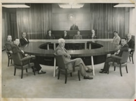
- Photograph of the 1956 Burnaby Municipal Council in Council Chambers at Burnaby Municipal Hall. Identified in the photograph are (starting at centre, forefront and moving clockwise): Gerald Charlton, Fred Philps, Wesley Morrison, Arnold Hean, Ted Ward (Deputy Municipal Clerk), John Shaw (Municipal…
- Repository
- City of Burnaby Archives
- Date
- 1956
- Collection/Fonds
- Charles MacSorley fonds
- Physical Description
- 1 photograph : b&w ; 20.5 x 25.5 cm
- Description Level
- Item
- Record No.
- 486-025
- Access Restriction
- No restrictions
- Reproduction Restriction
- Reproduce for fair dealing purposes only
- Accession Number
- 2005-14
- Scope and Content
- Photograph of the 1956 Burnaby Municipal Council in Council Chambers at Burnaby Municipal Hall. Identified in the photograph are (starting at centre, forefront and moving clockwise): Gerald Charlton, Fred Philps, Wesley Morrison, Arnold Hean, Ted Ward (Deputy Municipal Clerk), John Shaw (Municipal Clerk), Reeve Charles MacSorley (in the back), two unkown members of staff, Samuel Hughes, William Philps and Doug Drummond.
- Subjects
- Officials - Alderman and Councillors
- Officials - Mayors and Reeves
- Buildings - Civic - City Halls
- Occupations - City Clerks
- Occupations - Civic Workers
- Names
- Charlton, Gerald
- Philps, Fred
- Morrison, Wesley
- Hean, Arnold F.C.
- Ward, Ted
- Shaw, John Horace "Jack"
- MacSorley, Charles W.
- Hughes, Samuel E.
- Philps, William P.
- Drummond, John D. "Doug"
- Media Type
- Photograph
- Photographer
- Cunningham, W.
- Notes
- Title based on contents of photograph
- Photographer's stamp on verso
- Notes on verso identify the people in the photograph
- Geographic Access
- Canada Way
- Street Address
- 4949 Canada Way
- Historic Neighbourhood
- Burnaby Lake (Historic Neighbourhood)
- Planning Study Area
- Douglas-Gilpin Area
Images

Building fatigue
https://search.heritageburnaby.ca/link/archivedescription36566
- Repository
- City of Burnaby Archives
- Date
- 1952
- Collection/Fonds
- Burnaby Historical Society fonds
- Description Level
- Item
- Physical Description
- 1 photograph : b&w ; 17.5 x 12.5 cm print
- Scope and Content
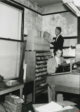
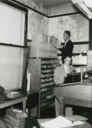
- Photograph of "BUILDING FATIGUE" inside the second Burnaby Municipal Hall.
- Repository
- City of Burnaby Archives
- Date
- 1952
- Collection/Fonds
- Burnaby Historical Society fonds
- Subseries
- Archie Miller subseries
- Physical Description
- 1 photograph : b&w ; 17.5 x 12.5 cm print
- Description Level
- Item
- Record No.
- 296-009
- Access Restriction
- No restrictions
- Reproduction Restriction
- Reproduce for fair dealing purposes only
- Accession Number
- BHS1992-36
- Scope and Content
- Photograph of "BUILDING FATIGUE" inside the second Burnaby Municipal Hall.
- Names
- Burnaby City Hall
- Media Type
- Photograph
- Photographer
- Dibble, Bob
- Notes
- Title taken from caption given to photograph in original pamphlet
- Photographs copies of originals used in "UNITE BURNABY" pamphlet which asked citizens to "VOTE YES" to the construction of a new Municipal Hall in Burnaby
- Geographic Access
- Kingsway
- Street Address
- 7282 Kingsway
- Historic Neighbourhood
- Edmonds (Historic Neighbourhood)
- Planning Study Area
- Stride Avenue Area
Images
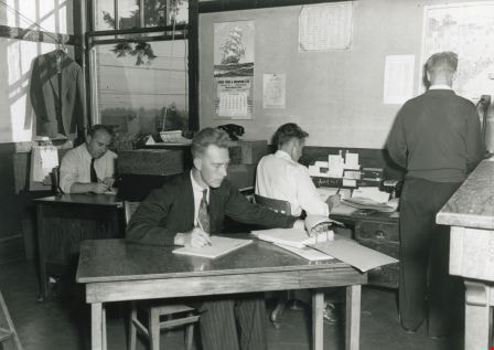
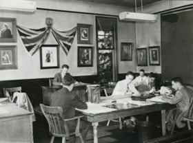
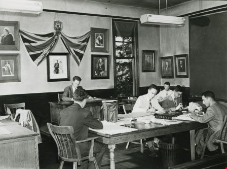
Interior of the Burnaby Municipal Hall
https://search.heritageburnaby.ca/link/archivedescription36568
- Repository
- City of Burnaby Archives
- Date
- 1952
- Collection/Fonds
- Burnaby Historical Society fonds
- Description Level
- Item
- Physical Description
- 1 photograph : b&w ; 12.5 x 17.5 cm print
- Scope and Content
- Photograph of secretaries working inside the second Burnaby Municipal Hall.
- Repository
- City of Burnaby Archives
- Date
- 1952
- Collection/Fonds
- Burnaby Historical Society fonds
- Subseries
- Archie Miller subseries
- Physical Description
- 1 photograph : b&w ; 12.5 x 17.5 cm print
- Description Level
- Item
- Record No.
- 296-011
- Access Restriction
- No restrictions
- Reproduction Restriction
- Reproduce for fair dealing purposes only
- Accession Number
- BHS1992-36
- Scope and Content
- Photograph of secretaries working inside the second Burnaby Municipal Hall.
- Names
- Burnaby City Hall
- Media Type
- Photograph
- Photographer
- Dibble, Bob
- Notes
- Title based on contents of photograph
- Geographic Access
- Kingsway
- Street Address
- 7282 Kingsway
- Historic Neighbourhood
- Edmonds (Historic Neighbourhood)
- Planning Study Area
- Stride Avenue Area
Images

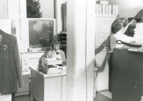
Over-crowded general office
https://search.heritageburnaby.ca/link/archivedescription36565
- Repository
- City of Burnaby Archives
- Date
- 1952
- Collection/Fonds
- Burnaby Historical Society fonds
- Description Level
- Item
- Physical Description
- 1 photograph : b&w ; 12.5 x 17.5 cm print
- Scope and Content
- Photograph of the "OVER-CROWDED GENERAL OFFICE" inside the second Burnaby Municipal Hall.
- Repository
- City of Burnaby Archives
- Date
- 1952
- Collection/Fonds
- Burnaby Historical Society fonds
- Subseries
- Archie Miller subseries
- Physical Description
- 1 photograph : b&w ; 12.5 x 17.5 cm print
- Description Level
- Item
- Record No.
- 296-008
- Access Restriction
- No restrictions
- Reproduction Restriction
- Reproduce for fair dealing purposes only
- Accession Number
- BHS1992-36
- Scope and Content
- Photograph of the "OVER-CROWDED GENERAL OFFICE" inside the second Burnaby Municipal Hall.
- Names
- Burnaby City Hall
- Media Type
- Photograph
- Photographer
- Dibble, Bob
- Notes
- Title taken from caption given to photograph in original pamphlet
- Photographs copies of originals used in "UNITE BURNABY" pamphlet which asked citizens to "VOTE YES" to the construction of a new Municipal Hall in Burnaby
- Geographic Access
- Kingsway
- Street Address
- 7282 Kingsway
- Historic Neighbourhood
- Edmonds (Historic Neighbourhood)
- Planning Study Area
- Stride Avenue Area
Images

Over-crowded police quarters
https://search.heritageburnaby.ca/link/archivedescription36567
- Repository
- City of Burnaby Archives
- Date
- 1952
- Collection/Fonds
- Burnaby Historical Society fonds
- Description Level
- Item
- Physical Description
- 1 photograph : b&w ; 12.5 x 17.5 cm print
- Scope and Content
- Photograph of the "OVER-CROWDED POLICE QUARTERS" inside the second Burnaby Municipal Hall.
- Repository
- City of Burnaby Archives
- Date
- 1952
- Collection/Fonds
- Burnaby Historical Society fonds
- Subseries
- Archie Miller subseries
- Physical Description
- 1 photograph : b&w ; 12.5 x 17.5 cm print
- Description Level
- Item
- Record No.
- 296-010
- Access Restriction
- No restrictions
- Reproduction Restriction
- Reproduce for fair dealing purposes only
- Accession Number
- BHS1992-36
- Scope and Content
- Photograph of the "OVER-CROWDED POLICE QUARTERS" inside the second Burnaby Municipal Hall.
- Media Type
- Photograph
- Photographer
- Dibble, Bob
- Notes
- Title taken from caption given to photograph in original pamphlet
- Photographs copies of originals used in "UNITE BURNABY" pamphlet which asked citizens to "VOTE YES" to the construction of a new Municipal Hall in Burnaby
- Geographic Access
- Kingsway
- Street Address
- 7282 Kingsway
- Historic Neighbourhood
- Edmonds (Historic Neighbourhood)
- Planning Study Area
- Stride Avenue Area
Images

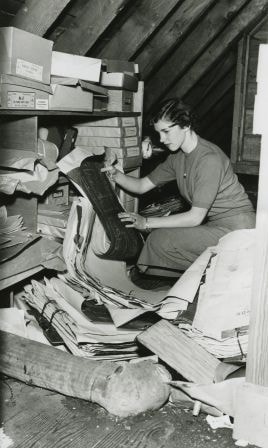
Plan filing room. Fire hazard???
https://search.heritageburnaby.ca/link/archivedescription36570
- Repository
- City of Burnaby Archives
- Date
- 1952
- Collection/Fonds
- Burnaby Historical Society fonds
- Description Level
- Item
- Physical Description
- 1 photograph : b&w ; 17.5 x 12.5 cm print
- Scope and Content
- Photograph of the "PLAN FILING ROOM [believed to be a] FIRE HAZZARD [sic]???" inside the second Burnaby Municipal Hall.
- Repository
- City of Burnaby Archives
- Date
- 1952
- Collection/Fonds
- Burnaby Historical Society fonds
- Subseries
- Archie Miller subseries
- Physical Description
- 1 photograph : b&w ; 17.5 x 12.5 cm print
- Description Level
- Item
- Record No.
- 296-013
- Access Restriction
- No restrictions
- Reproduction Restriction
- Reproduce for fair dealing purposes only
- Accession Number
- BHS1992-36
- Scope and Content
- Photograph of the "PLAN FILING ROOM [believed to be a] FIRE HAZZARD [sic]???" inside the second Burnaby Municipal Hall.
- Names
- Burnaby City Hall
- Media Type
- Photograph
- Photographer
- Dibble, Bob
- Notes
- Title taken from caption given to photograph in original pamphlet
- Photographs copies of originals used in "UNITE BURNABY" pamphlet which asked citizens to "VOTE YES" to the construction of a new Municipal Hall in Burnaby
- Geographic Access
- Kingsway
- Street Address
- 7282 Kingsway
- Historic Neighbourhood
- Edmonds (Historic Neighbourhood)
- Planning Study Area
- Stride Avenue Area
Images

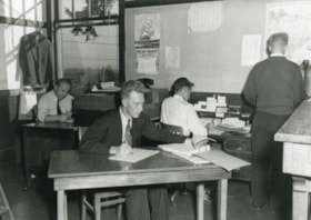
Staff using Council Chamber
https://search.heritageburnaby.ca/link/archivedescription36564
- Repository
- City of Burnaby Archives
- Date
- 1952
- Collection/Fonds
- Burnaby Historical Society fonds
- Description Level
- Item
- Physical Description
- 1 photograph : b&w ; 12.5 x 17.5 cm print
- Scope and Content
- Photograph of "STAFF USING COUNCIL CHAMBER" at the second Burnaby Municipal Hall.
- Repository
- City of Burnaby Archives
- Date
- 1952
- Collection/Fonds
- Burnaby Historical Society fonds
- Subseries
- Archie Miller subseries
- Physical Description
- 1 photograph : b&w ; 12.5 x 17.5 cm print
- Description Level
- Item
- Record No.
- 296-007
- Access Restriction
- No restrictions
- Reproduction Restriction
- Reproduce for fair dealing purposes only
- Accession Number
- BHS1992-36
- Scope and Content
- Photograph of "STAFF USING COUNCIL CHAMBER" at the second Burnaby Municipal Hall.
- Names
- Burnaby City Hall
- Media Type
- Photograph
- Photographer
- Dibble, Bob
- Notes
- Title taken from caption given to photograph in original pamphlet
- Photographs copies of originals used in "UNITE BURNABY" pamphlet which asked citizens to "VOTE YES" to the construction of a new Municipal Hall in Burnaby
- Geographic Access
- Kingsway
- Street Address
- 7282 Kingsway
- Historic Neighbourhood
- Edmonds (Historic Neighbourhood)
- Planning Study Area
- Stride Avenue Area
Images

Bob Hutton at Municipal Hall
https://search.heritageburnaby.ca/link/archivedescription37294
- Repository
- City of Burnaby Archives
- Date
- 1958
- Collection/Fonds
- Burnaby Historical Society fonds
- Description Level
- Item
- Physical Description
- 1 photograph : b&w ; 9 x 9 cm
- Scope and Content
- Photograph of a man identified as Bob Hutton outside Burnaby Municipal Hall. Two other men are visible in the picture, but neither is identified.
- Repository
- City of Burnaby Archives
- Date
- 1958
- Collection/Fonds
- Burnaby Historical Society fonds
- Subseries
- Norah Code subseries
- Physical Description
- 1 photograph : b&w ; 9 x 9 cm
- Description Level
- Item
- Record No.
- 345-015
- Access Restriction
- No restrictions
- Reproduction Restriction
- Reproduce for fair dealing purposes only
- Accession Number
- BHS1997-05
- Scope and Content
- Photograph of a man identified as Bob Hutton outside Burnaby Municipal Hall. Two other men are visible in the picture, but neither is identified.
- Subjects
- Buildings - Civic - City Halls
- Names
- Hutton, Bob
- Burnaby City Hall
- Media Type
- Photograph
- Photographer
- Code, Norah
- Notes
- Title based on contents of photograph.
- Photographs in this collection were taken and compiled by Norah Code, former editor of the "Burnaby Courier" newspaper during the course of her work for the newspaper.
- Geographic Access
- Canada Way
- Street Address
- 4949 Canada Way
- Historic Neighbourhood
- Burnaby Lake (Historic Neighbourhood)
- Planning Study Area
- Douglas-Gilpin Area
Images

![Burnaby Council, [1956] thumbnail](/media/hpo/_Data/_Archives_Images/_Unrestricted/204/204-803.jpg?width=280)
Burnaby Council
https://search.heritageburnaby.ca/link/archivedescription35943
- Repository
- City of Burnaby Archives
- Date
- [1956]
- Collection/Fonds
- Burnaby Historical Society fonds
- Description Level
- Item
- Physical Description
- 1 photograph : b&w ; 20.3 x 25.4 cm print
- Scope and Content
- Photograph of the Burnaby Council in chambers.
- Repository
- City of Burnaby Archives
- Date
- [1956]
- Collection/Fonds
- Burnaby Historical Society fonds
- Subseries
- Pioneer Tales subseries
- Physical Description
- 1 photograph : b&w ; 20.3 x 25.4 cm print
- Description Level
- Item
- Record No.
- 204-803
- Access Restriction
- No restrictions
- Reproduction Restriction
- Reproduce for fair dealing purposes only
- Accession Number
- BHS1988-03
- Scope and Content
- Photograph of the Burnaby Council in chambers.
- Subjects
- Officials - Alderman and Councillors
- Buildings - Civic - City Halls
- Officials - Mayors and Reeves
- Names
- Burnaby City Hall
- Media Type
- Photograph
- Photographer
- LeBlanc, Don
- Notes
- Title based on contents of photograph
- Geographic Access
- Canada Way
- Street Address
- 4949 Canada Way
- Historic Neighbourhood
- Burnaby Lake (Historic Neighbourhood)
- Planning Study Area
- Douglas-Gilpin Area
Images
![Burnaby Council, [1956] thumbnail](/media/hpo/_Data/_Archives_Images/_Unrestricted/204/204-803.jpg)
![Burnaby's new fleet of fire trucks, [1956 or 1957] thumbnail](/media/Hpo/_Data/_Archives_Images/_Unrestricted/205/226-001.jpg?width=280)
Burnaby's new fleet of fire trucks
https://search.heritageburnaby.ca/link/archivedescription36138
- Repository
- City of Burnaby Archives
- Date
- [1956 or 1957]
- Collection/Fonds
- Burnaby Historical Society fonds
- Description Level
- Item
- Physical Description
- 1 photograph : b&w ; 18.5 x 23.5 cm
- Scope and Content
- Photograph of the new fleet of Burnaby's 1956 American LaFrance pumper fire trucks lined in a row in front of the Municipal Hall. The fifth truck has its ladder extended. Reeve Charles MacSorley, Fire Chief William Menzies, and Councillor Fred Philps are standing in front of the second truck. There…
- Repository
- City of Burnaby Archives
- Date
- [1956 or 1957]
- Collection/Fonds
- Burnaby Historical Society fonds
- Physical Description
- 1 photograph : b&w ; 18.5 x 23.5 cm
- Description Level
- Item
- Record No.
- 226-001
- Access Restriction
- No restrictions
- Reproduction Restriction
- Reproduce for fair dealing purposes only
- Accession Number
- BHS1989-22
- Scope and Content
- Photograph of the new fleet of Burnaby's 1956 American LaFrance pumper fire trucks lined in a row in front of the Municipal Hall. The fifth truck has its ladder extended. Reeve Charles MacSorley, Fire Chief William Menzies, and Councillor Fred Philps are standing in front of the second truck. There is snow on the ground and the three men are wearing winter coats.
- Subjects
- Transportation - Fire Trucks
- Occupations - Fire Fighters
- Buildings - Civic - City Halls
- Officials - Alderman and Councillors
- Officials - Mayors and Reeves
- Media Type
- Photograph
- Photographer
- Dominion Photo Company
- Notes
- Title based on contents of photograph
- Other title info: photographer's negative no. 38487
- Street Address
- 4949 Canada Way
- Historic Neighbourhood
- Burnaby Lake (Historic Neighbourhood)
- Planning Study Area
- Douglas-Gilpin Area
Images
![Burnaby's new fleet of fire trucks, [1956 or 1957] thumbnail](/media/Hpo/_Data/_Archives_Images/_Unrestricted/205/226-001.jpg)

Burnaby's Third Municipal Hall - Canada Way
https://search.heritageburnaby.ca/link/archivedescription37289
- Repository
- City of Burnaby Archives
- Date
- 1958
- Collection/Fonds
- Burnaby Historical Society fonds
- Description Level
- Item
- Physical Description
- 1 photograph : b&w ; 13 x 17.7 cm
- Scope and Content
- Photograph of the exterior of Burnaby's third Municipal Hall. This hall was opened in 1956 on Grandview Highway (later, Canada Way) and it replaced the old hall at Kingsway and Edmonds Street.
- Repository
- City of Burnaby Archives
- Date
- 1958
- Collection/Fonds
- Burnaby Historical Society fonds
- Subseries
- Norah Code subseries
- Physical Description
- 1 photograph : b&w ; 13 x 17.7 cm
- Description Level
- Item
- Record No.
- 345-010
- Access Restriction
- No restrictions
- Reproduction Restriction
- Reproduce for fair dealing purposes only
- Accession Number
- BHS1997-05
- Scope and Content
- Photograph of the exterior of Burnaby's third Municipal Hall. This hall was opened in 1956 on Grandview Highway (later, Canada Way) and it replaced the old hall at Kingsway and Edmonds Street.
- Subjects
- Buildings - Civic - City Halls
- Names
- Burnaby City Hall
- Media Type
- Photograph
- Photographer
- Code, Norah
- Notes
- Title based on contents of photograph.
- Photographs in this collection were taken and compiled by Norah Code, former editor of the "Burnaby Courier" newspaper during the course of her work for the newspaper.
- Geographic Access
- Grandview Highway
- Canada Way
- Street Address
- 4949 Canada Way
- Historic Neighbourhood
- Burnaby Lake (Historic Neighbourhood)
- Planning Study Area
- Douglas-Gilpin Area
Images

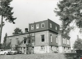
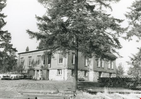
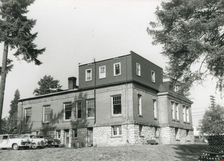
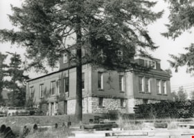
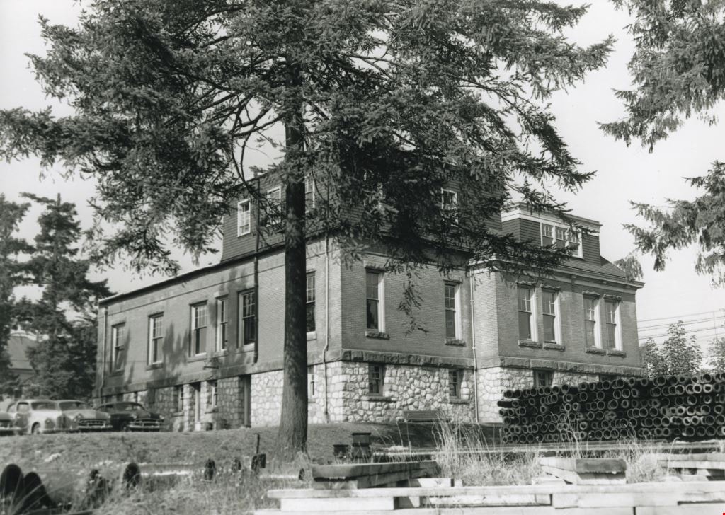
Exterior back of the Burnaby Municipal Hall
https://search.heritageburnaby.ca/link/archivedescription36562
- Repository
- City of Burnaby Archives
- Date
- 1952
- Collection/Fonds
- Burnaby Historical Society fonds
- Description Level
- Item
- Physical Description
- 1 photograph : b&w ; 12.5 x 17.5 cm print
- Scope and Content
- Photograph of the exterior side and back of the Burnaby Municipal Hall. Parked cars are visible in the parking lot at the back of the Hall, and piles of large pipes are visible along the side. This was the second Municipal Hall built.
- Repository
- City of Burnaby Archives
- Date
- 1952
- Collection/Fonds
- Burnaby Historical Society fonds
- Subseries
- Archie Miller subseries
- Physical Description
- 1 photograph : b&w ; 12.5 x 17.5 cm print
- Description Level
- Item
- Record No.
- 296-005
- Access Restriction
- No restrictions
- Reproduction Restriction
- Reproduce for fair dealing purposes only
- Accession Number
- BHS1992-36
- Scope and Content
- Photograph of the exterior side and back of the Burnaby Municipal Hall. Parked cars are visible in the parking lot at the back of the Hall, and piles of large pipes are visible along the side. This was the second Municipal Hall built.
- Subjects
- Buildings - Civic - City Halls
- Names
- Burnaby City Hall
- Media Type
- Photograph
- Photographer
- Dibble, Bob
- Notes
- Title based on contents of photograph
- Geographic Access
- Kingsway
- Street Address
- 7282 Kingsway
- Historic Neighbourhood
- Edmonds (Historic Neighbourhood)
- Planning Study Area
- Stride Avenue Area
Images
Exterior of the Burnaby Municipal Hall
https://search.heritageburnaby.ca/link/archivedescription36560
- Repository
- City of Burnaby Archives
- Date
- 1952
- Collection/Fonds
- Burnaby Historical Society fonds
- Description Level
- Item
- Physical Description
- 1 photograph : b&w ; 12.5 x 17.5 cm print
- Scope and Content
- Photograph of the exterior side and back of the Burnaby Municipal Hall. Parked cars are visible in the parking lot at the back of the Hall, and piles of large pipes and wooden 2" x 4"s are both visible along the side. This was the second Municipal Hall built.
- Repository
- City of Burnaby Archives
- Date
- 1952
- Collection/Fonds
- Burnaby Historical Society fonds
- Subseries
- Archie Miller subseries
- Physical Description
- 1 photograph : b&w ; 12.5 x 17.5 cm print
- Description Level
- Item
- Record No.
- 296-003
- Access Restriction
- No restrictions
- Reproduction Restriction
- Reproduce for fair dealing purposes only
- Accession Number
- BHS1992-36
- Scope and Content
- Photograph of the exterior side and back of the Burnaby Municipal Hall. Parked cars are visible in the parking lot at the back of the Hall, and piles of large pipes and wooden 2" x 4"s are both visible along the side. This was the second Municipal Hall built.
- Subjects
- Buildings - Civic - City Halls
- Names
- Burnaby City Hall
- Media Type
- Photograph
- Photographer
- Dibble, Bob
- Notes
- Title based on contents of photograph
- Geographic Access
- Kingsway
- Street Address
- 7282 Kingsway
- Historic Neighbourhood
- Edmonds (Historic Neighbourhood)
- Planning Study Area
- Stride Avenue Area
Images

Exterior of the Burnaby Municipal Hall
https://search.heritageburnaby.ca/link/archivedescription36561
- Repository
- City of Burnaby Archives
- Date
- 1952
- Collection/Fonds
- Burnaby Historical Society fonds
- Description Level
- Item
- Physical Description
- 1 photograph : b&w ; 12.5 x 17.5 cm print
- Scope and Content
- Photograph of the exterior side and back of the Burnaby Municipal Hall. Parked cars are visible in the parking lot at the back of the Hall, and piles of large pipes and wooden 2" x 4"s are both visible along the side. This was the second Municipal Hall built.
- Repository
- City of Burnaby Archives
- Date
- 1952
- Collection/Fonds
- Burnaby Historical Society fonds
- Subseries
- Archie Miller subseries
- Physical Description
- 1 photograph : b&w ; 12.5 x 17.5 cm print
- Description Level
- Item
- Record No.
- 296-004
- Access Restriction
- No restrictions
- Reproduction Restriction
- Reproduce for fair dealing purposes only
- Accession Number
- BHS1992-36
- Scope and Content
- Photograph of the exterior side and back of the Burnaby Municipal Hall. Parked cars are visible in the parking lot at the back of the Hall, and piles of large pipes and wooden 2" x 4"s are both visible along the side. This was the second Municipal Hall built.
- Subjects
- Buildings - Civic - City Halls
- Names
- Burnaby City Hall
- Media Type
- Photograph
- Photographer
- Dibble, Bob
- Notes
- Title based on contents of photograph
- Geographic Access
- Kingsway
- Street Address
- 7282 Kingsway
- Historic Neighbourhood
- Edmonds (Historic Neighbourhood)
- Planning Study Area
- Stride Avenue Area
Images