More like 'Bobbi Sami of Saafnet'
Narrow Results By
Decade
- 2020s 88
- 2010s 42
- 2000s 519
- 1990s 405
- 1980s 402
- 1970s 760
- 1960s 303
- 1950s 484
- 1940s
- 1930s 375
- 1920s
- 1910s 494
- 1900s 195
- 1890s 32
- 1880s 52
- 1870s 5
- 1860s 3
- 1850s 2
- 1840s 1
- 1830s 1
- 1820s 1
- 1810s 2
- 1800s 2
- 1790s 2
- 1780s 2
- 1770s 2
- 1760s 2
- 1750s 2
- 1740s 2
- 1730s 2
- 1720s 2
- 1710s 2
- 1700s 2
- 1690s 2
- 1680s 2
- 1670s 2
- 1660s 2
- 1650s 2
- 1640s 2
- 1630s 2
- 1620s 2
- 1610s 2
- 1600s 2
- 1590s 1
- 1580s 1
- 1570s 1
- 1560s 1
- 1550s 1
- 1540s 1
- 1530s 1
- 1520s 1
- 1510s 1
- 1500s 1
- 1490s 1
- 1480s 1
Subject
- Advertising Medium - Signs and Signboards 10
- Aerial Photographs 3
- Agricultural Tools and Equipment 7
- Agricultural Tools and Equipment - Cultivators 2
- Agricultural Tools and Equipment - Gardening Equipment 2
- Agricultural Tools and Equipment - Plows 2
- Agricultural Tools and Equipment - Tractors 1
- Agriculture - Crops 1
- Agriculture - Farms 11
- Agriculture - Poultry 3
- Animals - Cats 1
- Animals - Cows 1

E.W. Bateman House 'Elworth'
https://search.heritageburnaby.ca/link/landmark538
- Repository
- Burnaby Heritage Planning
- Description
- The E.W. Bateman House is a one-and-one-half storey wood-frame residence set within in a garden landscape. The house and its adjacent garage are the only historic buildings standing on their original site within the Burnaby Village Museum property.
- Associated Dates
- 1922
- Formal Recognition
- Heritage Designation, Community Heritage Register
- Other Names
- Edwin & Mary Bateman Residence
- Street View URL
- Google Maps Street View
- Repository
- Burnaby Heritage Planning
- Other Names
- Edwin & Mary Bateman Residence
- Geographic Access
- Deer Lake Avenue
- Associated Dates
- 1922
- Formal Recognition
- Heritage Designation, Community Heritage Register
- Enactment Type
- Bylaw No. 9807
- Enactment Date
- 23/11/1992
- Description
- The E.W. Bateman House is a one-and-one-half storey wood-frame residence set within in a garden landscape. The house and its adjacent garage are the only historic buildings standing on their original site within the Burnaby Village Museum property.
- Heritage Value
- The E.W. Bateman House was constructed in the Deer Lake Crescent subdivision, that was originally promoted in 1911 as an upper class suburban neighbourhood. It represents one of the first residential developments in the City of Burnaby that required buildings to be of a specific value, thus demonstrating the desire for exclusivity among the successful businessmen who chose to settle in the area. The house and grounds illustrate the reduced scale of upper-class residential construction at a time of modest returning prosperity that followed the end of the First World War, and the social, cultural, lifestyle and leisure sensibilities of the owners in the Deer Lake Crescent subdivision: such values as social aspiration, racial exclusivity, demonstration of architectural taste, and importance of a landscaped garden. The heritage value of the E.W. Bateman House is its comprehensive representation of an upper middle-class suburban residence of the early 1920s. It was built for retired CPR executive Edwin Wettenhall Bateman (1859-1957) and his wife, Mary (Dale) Bateman (1865-1935), by contractor William Dodson in 1922. The Bateman House was designed by English-born and trained architect Enoch Evans (1862-1939) of E. Evans and Son, and is an important surviving residential design by Evans, and a typical example of the eclectic Period Revival influences that were common to domestic architecture in the post-First World War era. The symmetry of the imposing front verandah, supported by exaggerated Ionic columns, gives the relatively-modest house an image of grandeur and formality. Named after Edwin Bateman’s birthplace in Cheshire, England, ‘Elworth’ also symbolizes allegiance to England and the patriotic tenor of the time. The heritage value for this house also lies in its interpretive value within the Burnaby Village Museum. The site is an important cultural feature for the interpretation of Burnaby’s heritage to the public. The E.W. Bateman House was purchased by Burnaby in 1970 and became the focal point for the development of the Museum. Both the interior and exterior of the house have been restored and interpreted to the date of original construction, including recreated room interiors and period furnishings.
- Defining Elements
- The elements that define the heritage character of the E.W. Bateman House include its: - rectangular form and massing with central entry on long side - side gable roof with front shed dormer with cedar shingle cladding - symmetry of front facade - full open front verandah inset under the roofline, supported with Ionic columns - cedar shingle siding - multi-paned double-hung wooden-sash windows, mixture of 6-over-1 and 8-over-1 - symmetrical disposition of fenestration, with double-assembly units on the ground floor - exterior shutters - two flanking brick chimneys on the side elevations - interior room layouts and original interior features such as quality millwork and original hardware - original garage at the rear of the house
- Locality
- Deer Lake Park
- Historic Neighbourhood
- Burnaby Lake (Historic Neighbourhood)
- Planning Study Area
- Morley-Buckingham Area
- Organization
- Burnaby Village Museum
- Architect
- Enoch Evans
- E. Evans and Son
- Builder
- William Dodson
- Function
- Primary Current--Museum
- Primary Historic--Single Dwelling
- Community
- Burnaby
- Cadastral Identifier
- P.I.D. No. 011-030-356 Legal Description: Parcel 1, District Lot 79 and District Lot 85, Group 1, New Westminster District, Reference Plan 77594
- Boundaries
- Burnaby Village Museum is comprised of a single municipally-owned property located at 6501 Deer Lake Avenue, Burnaby.
- Area
- 38,488.63
- Contributing Resource
- Building
- Landscape Feature
- Structure
- Ownership
- Public (local)
- Documentation
- Heritage Site Files: PC77000 20. City of Burnaby Planning and Building Department, 4949 Canada Way, Burnaby, B.C., V5G 1M2
- Subjects
- Buildings - Residential
- Buildings - Residential - Houses
- Buildings - Heritage
- Buildings - Civic - Museums
- Street Address
- 6501 Deer Lake Avenue
- Street View URL
- Google Maps Street View
Images


Barnet Lumber Company House
https://search.heritageburnaby.ca/link/landmark662
- Repository
- Burnaby Heritage Planning
- Description
- Residential building.
- Associated Dates
- 1925
- Street View URL
- Google Maps Street View
- Repository
- Burnaby Heritage Planning
- Geographic Access
- Texaco Drive
- Associated Dates
- 1925
- Description
- Residential building.
- Heritage Value
- This house is one of two surviving houses built as a “Model Home” for the manager of the Barnet Lumber Company, which was the successor to the North Pacific Lumber Company. It was used as a combined home and office. It was constructed with framing lumber and millwork sawn at the mill. Typical of the Craftsman style, the house has a front gabled roof with triangular eave brackets. It has been altered with the addition of asbestos shingles over the original siding, but retains its form, scale and massing. This house was designed by the firm of Townley & Matheson. The partnership of Fred Laughton Townley (1887-1966) and Robert Michael Matheson began in 1919, and the firm left a rich legacy of sophisticated work, including schools, commercial structures, many fine residences and the landmark Vancouver City Hall.
- Historic Neighbourhood
- Barnet (Historic Neighbourhood)
- Planning Study Area
- Burnaby Mountain Area
- Architect
- Townley & Matheson
- Area
- 2225.77
- Contributing Resource
- Building
- Ownership
- Public (local)
- Street Address
- 8007 Texaco Drive
- Street View URL
- Google Maps Street View
Images


Barnet Lumber Company House
https://search.heritageburnaby.ca/link/landmark663
- Repository
- Burnaby Heritage Planning
- Description
- Residential building.
- Associated Dates
- 1925
- Street View URL
- Google Maps Street View
- Repository
- Burnaby Heritage Planning
- Geographic Access
- Texaco Drive
- Associated Dates
- 1925
- Description
- Residential building.
- Heritage Value
- This house is one of two surviving houses built as a “Model Home” for one of the assistant managers of the Barnet Lumber Company, using framing lumber and millwork sawn at the mill. This house was also designed by the firm of Townley & Matheson. The house was raised and renovated in 1997, resulting in alterations such as new dormers and elongated porch piers.
- Historic Neighbourhood
- Barnet (Historic Neighbourhood)
- Planning Study Area
- Burnaby Mountain Area
- Architect
- Townley & Matheson
- Contributing Resource
- Building
- Ownership
- Private
- Street Address
- 8039 Texaco Drive
- Street View URL
- Google Maps Street View
Images


Capitol Hill Community Hall
https://search.heritageburnaby.ca/link/landmark563
- Repository
- Burnaby Heritage Planning
- Description
- Public building.
- Associated Dates
- 1948
- Street View URL
- Google Maps Street View
- Repository
- Burnaby Heritage Planning
- Geographic Access
- Howard Avenue
- Associated Dates
- 1948
- Description
- Public building.
- Heritage Value
- The Capitol Hill Community Hall was designed by local architect Harold Cullerne (1890-1976). After Cullerne returned from service during the First World War, he joined J.H. Bowman in a partnership that lasted from 1919 to 1934. After Bowman retired in 1934, Cullerne practiced on his own, continuing to work on schools and institutional buildings, such as the Art Deco Hollywood Theatre in Vancouver. In 1944, Cullerne designed a community hall for Capitol Hill; the scheme was delayed, and redesigned before it was finally built after the end of the Second World War. A simple front gabled roof hall structure, this hall is a monument to community spirit, erected by community members on a volunteer basis, and used for community events for over half a century. The hall replaced two earlier structures, both destroyed by fire, that had served the same purpose.
- Locality
- Capitol Hill
- Historic Neighbourhood
- Capitol Hill (Historic Neighbourhood)
- Planning Study Area
- Capitol Hill Area
- Architect
- Harold Cullerne
- Ownership
- Public (local)
- Street Address
- 361 Howard Avenue
- Street View URL
- Google Maps Street View
Images


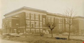
Capitol Hill School
https://search.heritageburnaby.ca/link/landmark564
- Repository
- Burnaby Heritage Planning
- Description
- School building.
- Associated Dates
- 1923
- Other Names
- Ecole Capitol Hill Elementary School
- Street View URL
- Google Maps Street View
- Repository
- Burnaby Heritage Planning
- Other Names
- Ecole Capitol Hill Elementary School
- Geographic Access
- Holdom Avenue
- Associated Dates
- 1923
- Description
- School building.
- Heritage Value
- This school was originally designed by Bowman & Cullerne as a two-storey, four-room school building in 1923, with a two-room addition completed in 1926 and another in 1927. Originally designed in the Arts and Crafts style, it has been altered, with the addition of stucco over the original siding and replacement windows, but has retained its original form and massing, as well as its roof-top ventilator and front gabled entrance with grouped columns. Bowman & Cullerne specialized in school design. After Harold Cullerne (1890-1976) returned from service during the First World War, he joined J.H. Bowman (1864-1943) in a partnership that lasted from 1919 to 1934. The firm’s other school designs included Seaforth School (1922, now relocated to Burnaby Village Museum), Burnaby North High School (1923), and Nelson Avenue School (1927).
- Locality
- Capitol Hill
- Historic Neighbourhood
- Capitol Hill (Historic Neighbourhood)
- Planning Study Area
- Capitol Hill Area
- Architect
- Bowman & Cullerne
- Ownership
- Public (local)
- Subjects
- Buildings - Heritage
- Buildings - Schools
- Street Address
- 350 Holdom Avenue
- Street View URL
- Google Maps Street View
Images


Douglas Road School
https://search.heritageburnaby.ca/link/landmark573
- Repository
- Burnaby Heritage Planning
- Description
- School building.
- Associated Dates
- 1928
- Other Names
- Douglas Road Elementary School
- Street View URL
- Google Maps Street View
- Repository
- Burnaby Heritage Planning
- Other Names
- Douglas Road Elementary School
- Geographic Access
- Canada Way
- Associated Dates
- 1928
- Description
- School building.
- Heritage Value
- The Douglas Road School was originally established as a two-room school in 1908 on this site, and later expanded to four classrooms. Anticipating rapid settlement of this district, the School Board purchased two acres adjoining the old building. Two of the four rooms were designed to become one large auditorium suitable for special events and public gatherings, with seating for two hundred people. The classically-influenced school has been altered with new windows and extended with additional wings, but has retained its original red-brick veneer, tan-brick quoins and bellcast octagonal roof ventilator. Designed by McCarter & Nairne, the school was built by contractor A.S. Perry. McCarter & Nairne, who also designed the Second Street School, were the Burnaby School Board architects at this time. John Y. McCarter (1886-1981) and George Nairne (1884-1953) formed their partnership in 1921 after serving overseas during the First World War. The partners began designing houses and small apartment buildings, and their commissions included Vancouver’s first skyscraper, the Marine Building (1928-30).
- Locality
- Burnaby Lake
- Historic Neighbourhood
- Burnaby Lake (Historic Neighbourhood)
- Planning Study Area
- Douglas-Gilpin Area
- Architect
- McCarter & Nairne
- Subjects
- Buildings - Heritage
- Buildings - Schools
- Street Address
- 4861 Canada Way
- Street View URL
- Google Maps Street View
Images


Switchboard
https://search.heritageburnaby.ca/link/archivedescription34710
- Repository
- City of Burnaby Archives
- Date
- 1943
- Collection/Fonds
- Burnaby Historical Society fonds
- Description Level
- Item
- Physical Description
- 1 photograph : b&w ; 20.0 x 25.5 cm
- Scope and Content
- Photograph of the interior of a switchboard, probably the Dexter exchange at Boundary Road and Kingsway. A typed description on the back of the photograph reads, "A Manual Switchboard, typical of about 25 years ago. / Dexter, 1943. / B.C. Telephone Company."
- Repository
- City of Burnaby Archives
- Date
- 1943
- Collection/Fonds
- Burnaby Historical Society fonds
- Subseries
- Photographs subseries
- Physical Description
- 1 photograph : b&w ; 20.0 x 25.5 cm
- Material Details
- Printed on photo paper: "selo"
- Description Level
- Item
- Record No.
- 114-001
- Access Restriction
- No restrictions
- Reproduction Restriction
- No known restrictions
- Accession Number
- BHS2007-04
- Scope and Content
- Photograph of the interior of a switchboard, probably the Dexter exchange at Boundary Road and Kingsway. A typed description on the back of the photograph reads, "A Manual Switchboard, typical of about 25 years ago. / Dexter, 1943. / B.C. Telephone Company."
- Subjects
- Telecommunication Tools and Equipment
- Buildings - Commercial
- Occupations - Telephone Operators
- Media Type
- Photograph
- Photographer
- Dominion Photo Company
- Notes
- Title based on contents of photograph
- Printed in bottom left corner of photograph, "27038 Dominion Photo Co., Vancouver B.C."
- Geographic Access
- Boundary Road
- Kingsway
- Historic Neighbourhood
- Central Park (Historic Neighbourhood)
- Planning Study Area
- Garden Village Area
Images

![Alice and William Goodridge in front of store, [between 1925 and 1935] thumbnail](/media/hpo/_Data/_BVM_Images/2023/2023_0015_0001_001.jpg?width=280)
Alice and William Goodridge in front of store
https://search.heritageburnaby.ca/link/museumdescription20274
- Repository
- Burnaby Village Museum
- Date
- [between 1925 and 1935]
- Collection/Fonds
- Burnaby Village Museum Photograph collection
- Description Level
- Item
- Physical Description
- 1 photograph : b&w negative ; 12.5 x 10 cm
- Scope and Content
- Photograph of Alice Victoria (Goodridge) Norman and her brother William "Bill" Goodridge seated on the stoop outside the Goodridge grocery store located at 4835 Hastings Street in Burnaby. Signage on the windows and on the front of the store identify some of the trademarks of products sold in the s…
- Repository
- Burnaby Village Museum
- Collection/Fonds
- Burnaby Village Museum Photograph collection
- Description Level
- Item
- Physical Description
- 1 photograph : b&w negative ; 12.5 x 10 cm
- Scope and Content
- Photograph of Alice Victoria (Goodridge) Norman and her brother William "Bill" Goodridge seated on the stoop outside the Goodridge grocery store located at 4835 Hastings Street in Burnaby. Signage on the windows and on the front of the store identify some of the trademarks of products sold in the store including "Royal Crown Soap", "Cowan's" and "Winchester cigarettes". Two post office boxes are visible to the right of the couple.
- Subjects
- Buildings - Commercial
- Buildings - Commercial - Grocery Stores
- Buildings - Public - Post Offices
- Accession Code
- BV023.15.1
- Access Restriction
- No restrictions
- Reproduction Restriction
- No known restrictions
- Date
- [between 1925 and 1935]
- Media Type
- Photograph
- Scan Resolution
- 3200
- Scan Date
- 2023-09-21
- Notes
- Title based on contents of photograph
- 1 b&w contact sheet accompanying
Images
![Alice and William Goodridge in front of store, [between 1925 and 1935] thumbnail](/media/hpo/_Data/_BVM_Images/2023/2023_0015_0001_001.jpg)
![John Charles Goodridge holding grandchild, [between 1925 and 1935] thumbnail](/media/hpo/_Data/_BVM_Images/2023/2023_0015_0004_001.jpg?width=280)
John Charles Goodridge holding grandchild
https://search.heritageburnaby.ca/link/museumdescription20278
- Repository
- Burnaby Village Museum
- Date
- [between 1925 and 1935]
- Collection/Fonds
- Burnaby Village Museum Photograph collection
- Description Level
- Item
- Physical Description
- 1 photograph : b&w negative ; 12.5 x 10 cm
- Scope and Content
- Photograph of John Charles Bertram Goodridge holding his grandchild outside the Goodridge grocery store on Hastings Street in Burnaby. Canada Post mail boxes are visible behind them. One of the mail boxes is mounted on the door of the building and the other is free standing.
- Repository
- Burnaby Village Museum
- Collection/Fonds
- Burnaby Village Museum Photograph collection
- Description Level
- Item
- Physical Description
- 1 photograph : b&w negative ; 12.5 x 10 cm
- Scope and Content
- Photograph of John Charles Bertram Goodridge holding his grandchild outside the Goodridge grocery store on Hastings Street in Burnaby. Canada Post mail boxes are visible behind them. One of the mail boxes is mounted on the door of the building and the other is free standing.
- Subjects
- Buildings - Commercial
- Buildings - Commercial - Grocery Stores
- Buildings - Public - Post Offices
- Persons - Children
- Accession Code
- BV023.15.4
- Access Restriction
- No restrictions
- Reproduction Restriction
- No known restrictions
- Date
- [between 1925 and 1935]
- Media Type
- Photograph
- Scan Resolution
- 3200
- Scan Date
- 2023-09-21
- Notes
- Title based on contents of photograph
- 1 b&w contact sheet accompanying
Images
![John Charles Goodridge holding grandchild, [between 1925 and 1935] thumbnail](/media/hpo/_Data/_BVM_Images/2023/2023_0015_0004_001.jpg)
![Lucy Goodridge with grandson, [between 1925 and 1935] thumbnail](/media/hpo/_Data/_BVM_Images/2023/2023_0015_0007_001.jpg?width=280)
Lucy Goodridge with grandson
https://search.heritageburnaby.ca/link/museumdescription20281
- Repository
- Burnaby Village Museum
- Date
- [between 1925 and 1935]
- Collection/Fonds
- Burnaby Village Museum Photograph collection
- Description Level
- Item
- Physical Description
- 1 photograph : b&w negative ; 10 x 12.5 cm
- Scope and Content
- Photograph of Lucy Elston Goodridge holding her grandchild outside the Goodridge grocery store located at 4835 Hastings Street in Burnaby. Canada Post mail boxes are visible behind them. One of the mail boxes is mounted on the door of the building and the other is free standing.
- Repository
- Burnaby Village Museum
- Collection/Fonds
- Burnaby Village Museum Photograph collection
- Description Level
- Item
- Physical Description
- 1 photograph : b&w negative ; 10 x 12.5 cm
- Scope and Content
- Photograph of Lucy Elston Goodridge holding her grandchild outside the Goodridge grocery store located at 4835 Hastings Street in Burnaby. Canada Post mail boxes are visible behind them. One of the mail boxes is mounted on the door of the building and the other is free standing.
- Subjects
- Buildings - Commercial
- Buildings - Commercial - Grocery Stores
- Persons - Children
- Buildings - Public - Post Offices
- Names
- Goodridge, Lucy Elston
- Accession Code
- BV023.15.7
- Access Restriction
- No restrictions
- Reproduction Restriction
- No known restrictions
- Date
- [between 1925 and 1935]
- Media Type
- Photograph
- Scan Resolution
- 3200
- Scan Date
- 2023-09-21
- Notes
- Title based on contents of photograph
- 1 b&w contact sheet accompanying
Images
![Lucy Goodridge with grandson, [between 1925 and 1935] thumbnail](/media/hpo/_Data/_BVM_Images/2023/2023_0015_0007_001.jpg)
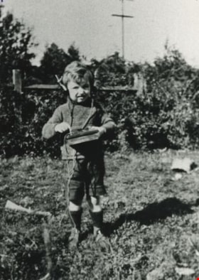
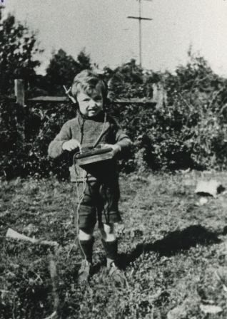
Bill Campbell with Crystal Radio Set
https://search.heritageburnaby.ca/link/archivedescription35787
- Repository
- City of Burnaby Archives
- Date
- 1923 (date of original), copied 1986
- Collection/Fonds
- Burnaby Historical Society fonds
- Description Level
- Item
- Physical Description
- 1 photograph : b&w ; 12.7 x 17.8 cm print
- Scope and Content
- Photograph of Bill Campbell with a crystal radio set built by his father, John Campbell.
- Repository
- City of Burnaby Archives
- Date
- 1923 (date of original), copied 1986
- Collection/Fonds
- Burnaby Historical Society fonds
- Subseries
- Pioneer Tales subseries
- Physical Description
- 1 photograph : b&w ; 12.7 x 17.8 cm print
- Description Level
- Item
- Record No.
- 204-645
- Access Restriction
- No restrictions
- Reproduction Restriction
- No known restrictions
- Accession Number
- BHS1988-03
- Scope and Content
- Photograph of Bill Campbell with a crystal radio set built by his father, John Campbell.
- Names
- Campbell, William "Bill"
- Media Type
- Photograph
- Notes
- Title based on contents of photograph
- Geographic Access
- Eton Street
- Street Address
- 4120 Eton Street
- Historic Neighbourhood
- Vancouver Heights (Historic Neighbourhood)
- Planning Study Area
- Burnaby Heights Area
Images
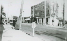
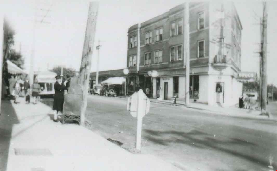
Edmonds Street and Kingsway
https://search.heritageburnaby.ca/link/archivedescription37823
- Repository
- City of Burnaby Archives
- Date
- 1944 (date of original), copied 1991
- Collection/Fonds
- Burnaby Historical Society fonds
- Description Level
- Item
- Physical Description
- 1 photograph : b&w ; 2.8 x 4.5 cm print on contact sheet 20.3 x 26.4 cm
- Scope and Content
- Photograph of the intersection of Edmonds Street and Kingsway. The triangular Edmonds Block can be seen at the right and Ruth Hollands is visible putting a letter in a mailbox.
- Repository
- City of Burnaby Archives
- Date
- 1944 (date of original), copied 1991
- Collection/Fonds
- Burnaby Historical Society fonds
- Subseries
- Burnaby Image Bank subseries
- Physical Description
- 1 photograph : b&w ; 2.8 x 4.5 cm print on contact sheet 20.3 x 26.4 cm
- Description Level
- Item
- Record No.
- 370-411
- Access Restriction
- No restrictions
- Reproduction Restriction
- No known restrictions
- Accession Number
- BHS1999-03
- Scope and Content
- Photograph of the intersection of Edmonds Street and Kingsway. The triangular Edmonds Block can be seen at the right and Ruth Hollands is visible putting a letter in a mailbox.
- Names
- Hollands, Ruth
- Media Type
- Photograph
- Notes
- Title based on contents of photograph
- 2 b&w copy prints accompanying
- 1 b&w copy negative accompanying
- Negative has a pink cast
- Geographic Access
- Edmonds Street
- Kingsway
- Historic Neighbourhood
- Edmonds (Historic Neighbourhood)
Images
![Wally Westerman, [194-] thumbnail](/media/hpo/_Data/_BVM_Images/2020/2020_0017_0010_001.jpg?width=280)
Wally Westerman
https://search.heritageburnaby.ca/link/museumdescription13686
- Repository
- Burnaby Village Museum
- Date
- [194-]
- Collection/Fonds
- Westerman family fonds
- Description Level
- Item
- Physical Description
- 1 photograph : b&w ; 8.2 x 11 cm
- Scope and Content
- Photograph of Walter "Wally" Westerman posing on a piece of farming equipment on an unidentified farm. Another piece of farming equipment is visible behind him.
- Repository
- Burnaby Village Museum
- Collection/Fonds
- Westerman family fonds
- Description Level
- Item
- Physical Description
- 1 photograph : b&w ; 8.2 x 11 cm
- Scope and Content
- Photograph of Walter "Wally" Westerman posing on a piece of farming equipment on an unidentified farm. Another piece of farming equipment is visible behind him.
- Subjects
- Agricultural Tools and Equipment
- Agricultural Tools and Equipment - Cultivators
- Agricultural Tools and Equipment - Tractors
- Accession Code
- BV020.17.10
- Access Restriction
- No restrictions
- Reproduction Restriction
- No known restrictions
- Date
- [194-]
- Media Type
- Photograph
- Scan Resolution
- 600
- Scan Date
- 22-Sep-2020
- Scale
- 100
- Notes
- Title based on contents of photograph
- Stamp on verso of photograph reads: "587"
Images
![Wally Westerman, [194-] thumbnail](/media/hpo/_Data/_BVM_Images/2020/2020_0017_0010_001.jpg)
Interview with Cice Brown, May 13, 2005 - Track 2
https://search.heritageburnaby.ca/link/museumdescription4477
- Repository
- Burnaby Village Museum
- Date
- 1930-1949 (interview content), interviewed May 10, 2005
- Collection/Fonds
- Burnaby Village Museum fonds
- Description Level
- Item
- Physical Description
- 1 sound recording (mp3) (0:06:11 min)
- Scope and Content
- Track 2: This portion of the recording pertains to responsibilities, chores, and money. Cice recalls her chores, and how she spent her allowance. She describes her jobs in Mr. Pitman’s drygoods stores, on Kingsway and on Jubilee Ave., and in Anne Reid’s candy shop. Asked about church, Cice discuss…
- Repository
- Burnaby Village Museum
- Collection/Fonds
- Burnaby Village Museum fonds
- Series
- Museum Oral Histories series
- Subseries
- Growing Up in Burnaby subseries
- Description Level
- Item
- Physical Description
- 1 sound recording (mp3) (0:06:11 min)
- Material Details
- Interviewer: Tom Gooden Interviewee: Cice Brown Date of interview: May 13, 2005 Total Number of Tracks: 7 Total length of all Tracks: 0:40:19
- Scope and Content
- Track 2: This portion of the recording pertains to responsibilities, chores, and money. Cice recalls her chores, and how she spent her allowance. She describes her jobs in Mr. Pitman’s drygoods stores, on Kingsway and on Jubilee Ave., and in Anne Reid’s candy shop. Asked about church, Cice discusses her involvement with the Henderson-Jubilee United church, and C.G.I.T..
- History
- Recording of an interview with Cice Brown, interviewed by Tom Gooden on May 13 2005. This recording was completed for an exhibit, Growing Up in Burnaby, for the Burnaby Village Museum. Major themes discussed are growing up in Burnaby in the 1930s and 40s.
- Creator
- Burnaby Village Museum
- Subjects
- Buildings - Commercial - General Stores
- Buildings - Commercial - Grocery Stores
- Buildings - Commercial - Stores
- Names
- Brown, Cice Chandler
- Geographic Access
- Kingsway
- Jubilee Avenue
- Accession Code
- BV017.45.3
- Access Restriction
- No restrictions
- Date
- 1930-1949 (interview content), interviewed May 10, 2005
- Media Type
- Sound Recording
- Notes
- Title based on contents of item
Audio Tracks
Interview with Cice Brown, May 13, 2005 - Track 2, 1930-1949 (interview content), interviewed May 10, 2005
Interview with Cice Brown, May 13, 2005 - Track 2, 1930-1949 (interview content), interviewed May 10, 2005
https://search.heritageburnaby.ca/media/hpo/_Data/_BVM_Sound_Recordings/Oral_Histories/2017_0045_0003_002.mp3![Blacksmith shops, [194-?] (date of originals), copied [1971] thumbnail](/media/hpo/_Data/_BVM_Images/2000/200000180008.jpg?width=280)
Blacksmith shops
https://search.heritageburnaby.ca/link/museumdescription1947
- Repository
- Burnaby Village Museum
- Date
- [194-?] (date of originals), copied [1971]
- Collection/Fonds
- Burnaby Centennial '71 Committee collection
- Description Level
- Item
- Physical Description
- 1 photograph : b&w composite ; 26 x 30.5 cm, mounted on cardboard 32 x 39 cm
- Scope and Content
- Composite photograph of various aspects of unidentified blacksmith shops including interiors, equipment and exteriors.
- Repository
- Burnaby Village Museum
- Collection/Fonds
- Burnaby Centennial '71 Committee collection
- Description Level
- Item
- Physical Description
- 1 photograph : b&w composite ; 26 x 30.5 cm, mounted on cardboard 32 x 39 cm
- Material Details
- Composite is comprised of ten photographs
- Scope and Content
- Composite photograph of various aspects of unidentified blacksmith shops including interiors, equipment and exteriors.
- Names
- Burnaby Village Museum
- Accession Code
- BV000.18.8
- Access Restriction
- Restricted access
- Reproduction Restriction
- May be restricted by third party rights
- Date
- [194-?] (date of originals), copied [1971]
- Media Type
- Photograph
- Arrangement
- Record appears to be a part of the Burnaby Centennial Committee or the Century Park Museum Associaton. Jon Newby was a board member of either of these committees.
- Scan Resolution
- 600
- Scan Date
- 1/8/2010
- Scale
- 100
- Notes
- Title based on contents of photograph
Images
![Blacksmith shops, [194-?] (date of originals), copied [1971] thumbnail](/media/hpo/_Data/_BVM_Images/2000/200000180008.jpg)

Dyke construction on Nicomen Island
https://search.heritageburnaby.ca/link/archivedescription34331
- Repository
- City of Burnaby Archives
- Date
- 1927
- Collection/Fonds
- Burnaby Historical Society fonds
- Description Level
- Item
- Physical Description
- 1 photograph : sepia ; 7 x 13.5 cm on page 17.5 x 22.7 cm
- Scope and Content
- Photograph of a home, with car in the foreground next to equipment being used in the construction of dykes on Nicomen Island.
- Repository
- City of Burnaby Archives
- Date
- 1927
- Collection/Fonds
- Burnaby Historical Society fonds
- Subseries
- Peers family subseries
- Physical Description
- 1 photograph : sepia ; 7 x 13.5 cm on page 17.5 x 22.7 cm
- Description Level
- Item
- Record No.
- 020-038
- Access Restriction
- No restrictions
- Reproduction Restriction
- No known restrictions
- Accession Number
- BHS2007-04
- Scope and Content
- Photograph of a home, with car in the foreground next to equipment being used in the construction of dykes on Nicomen Island.
- Subjects
- Construction Tools and Equipment
- Geographic Features - Dykes
- Buildings - Residential - Houses
- Media Type
- Photograph
- Notes
- Title based on caption accompanying photograph
Images


Gilmore Avenue and Douglas Road
https://search.heritageburnaby.ca/link/archivedescription34112
- Repository
- City of Burnaby Archives
- Date
- March 27, 1947
- Collection/Fonds
- Burnaby Historical Society fonds
- Description Level
- Item
- Physical Description
- 1 photograph : b&w negative ; 6.8 x 11.6 cm
- Scope and Content
- Photograph of Gilmore Avenue and Douglas Road with a car parked at the side of the road and two men with surveying equipment. This is part of the Willingdon Heights subdivision site.
- Repository
- City of Burnaby Archives
- Date
- March 27, 1947
- Collection/Fonds
- Burnaby Historical Society fonds
- Subseries
- Alfred Bingham subseries
- Physical Description
- 1 photograph : b&w negative ; 6.8 x 11.6 cm
- Description Level
- Item
- Record No.
- 010-028
- Access Restriction
- No restrictions
- Reproduction Restriction
- No known restrictions
- Accession Number
- BHS2007-04
- Scope and Content
- Photograph of Gilmore Avenue and Douglas Road with a car parked at the side of the road and two men with surveying equipment. This is part of the Willingdon Heights subdivision site.
- Subjects
- Industries - Construction
- Buildings - Residential - Houses
- Construction Tools and Equipment
- Media Type
- Photograph
- Photographer
- Bingham, Alfred "Alf"
- Notes
- Title based on contents of photograph
- Geographic Access
- Gilmore Avenue
- Douglas Road
Images

Gilmore School addition
https://search.heritageburnaby.ca/link/archivedescription38678
- Repository
- City of Burnaby Archives
- Date
- 1928
- Collection/Fonds
- Burnaby Historical Society fonds
- Description Level
- Item
- Physical Description
- 1 photograph : b&w ; 11 x 20.7 cm
- Scope and Content
- Photograph of the Gilmore School addition being built. Piles of lumber can be seen on the ground in front of the building and an unidentified man is standing by the lower window in the centre of the photograph.
- Repository
- City of Burnaby Archives
- Date
- 1928
- Collection/Fonds
- Burnaby Historical Society fonds
- Subseries
- North Burnaby Board of Trade subseries
- Physical Description
- 1 photograph : b&w ; 11 x 20.7 cm
- Description Level
- Item
- Record No.
- 476-021
- Access Restriction
- No restrictions
- Reproduction Restriction
- No known restrictions
- Accession Number
- BHS2005-8
- Scope and Content
- Photograph of the Gilmore School addition being built. Piles of lumber can be seen on the ground in front of the building and an unidentified man is standing by the lower window in the centre of the photograph.
- Names
- Gilmore Avenue School
- Media Type
- Photograph
- Notes
- Title based on content of photograph
- Geographic Access
- Gilmore Avenue
- Street Address
- 50 Gilmore Avenue
- Historic Neighbourhood
- Vancouver Heights (Historic Neighbourhood)
- Planning Study Area
- Burnaby Heights Area
Images


Land clearing machines
https://search.heritageburnaby.ca/link/archivedescription34108
- Repository
- City of Burnaby Archives
- Date
- March 16, 1947
- Collection/Fonds
- Burnaby Historical Society fonds
- Description Level
- Item
- Physical Description
- 1 photograph : b&w negative ; 6.8 x 11.4 cm
- Scope and Content
- Photograph of land clearing machines at 4124 Napier Street. Partially constructed houses and lumber are visible, and a sign on the side of a bulldozer reads "Holmes and Wilson Trucking." This is part of the Willingdon Heights subdivision site.
- Repository
- City of Burnaby Archives
- Date
- March 16, 1947
- Collection/Fonds
- Burnaby Historical Society fonds
- Subseries
- Alfred Bingham subseries
- Physical Description
- 1 photograph : b&w negative ; 6.8 x 11.4 cm
- Description Level
- Item
- Record No.
- 010-024
- Access Restriction
- No restrictions
- Reproduction Restriction
- No known restrictions
- Accession Number
- BHS2007-04
- Scope and Content
- Photograph of land clearing machines at 4124 Napier Street. Partially constructed houses and lumber are visible, and a sign on the side of a bulldozer reads "Holmes and Wilson Trucking." This is part of the Willingdon Heights subdivision site.
- Media Type
- Photograph
- Photographer
- Bingham, Alfred "Alf"
- Notes
- Title based on contents of photograph
- Geographic Access
- Napier Street
- Street Address
- 4124 Napier Street
Images


London mixer and contractors
https://search.heritageburnaby.ca/link/archivedescription34138
- Repository
- City of Burnaby Archives
- Date
- April 16, 1947
- Collection/Fonds
- Burnaby Historical Society fonds
- Description Level
- Item
- Physical Description
- 1 photograph : b&w negative ; 6.8 x 11.8 cm
- Scope and Content
- Photograph of Gilmore Avenue and Douglas Road including a London mixer and contractors invovled in house construction. The man standing in the center has been identified as Mr. Marcowitz. This is part of the Willingdon Heights subdivision site.
- Repository
- City of Burnaby Archives
- Date
- April 16, 1947
- Collection/Fonds
- Burnaby Historical Society fonds
- Subseries
- Alfred Bingham subseries
- Physical Description
- 1 photograph : b&w negative ; 6.8 x 11.8 cm
- Description Level
- Item
- Record No.
- 010-054
- Access Restriction
- No restrictions
- Reproduction Restriction
- Reproduce for fair dealing purposes only
- Accession Number
- BHS2007-04
- Scope and Content
- Photograph of Gilmore Avenue and Douglas Road including a London mixer and contractors invovled in house construction. The man standing in the center has been identified as Mr. Marcowitz. This is part of the Willingdon Heights subdivision site.
- Subjects
- Occupations - Labourers
- Industries - Construction
- Construction Tools and Equipment
- Buildings - Residential - Houses
- Media Type
- Photograph
- Photographer
- Bingham, Alfred "Alf"
- Notes
- Title based on contents of photograph
- Geographic Access
- Gilmore Avenue
- Douglas Road
Images
