More like 'New Vista Society Care Centre new exercise room'
Narrow Results By
Decade
- 2020s 132
- 2010s 84
- 2000s 1020
- 1990s 568
- 1980s 500
- 1970s 1064
- 1960s 379
- 1950s 587
- 1940s 565
- 1930s
- 1920s
- 1910s 488
- 1900s 211
- 1890s 35
- 1880s 52
- 1870s 6
- 1860s 3
- 1850s 1
- 1840s 1
- 1830s 2
- 1820s 1
- 1810s 1
- 1800s 1
- 1790s 1
- 1780s 1
- 1770s 1
- 1760s 1
- 1750s 1
- 1740s 1
- 1730s 1
- 1720s 1
- 1710s 1
- 1700s 1
- 1690s 1
- 1680s 1
- 1670s 1
- 1660s 1
- 1650s 1
- 1640s 1
- 1630s 1
- 1620s 1
- 1610s 1
- 1600s 1

E.W. Bateman House 'Elworth'
https://search.heritageburnaby.ca/link/landmark538
- Repository
- Burnaby Heritage Planning
- Description
- The E.W. Bateman House is a one-and-one-half storey wood-frame residence set within in a garden landscape. The house and its adjacent garage are the only historic buildings standing on their original site within the Burnaby Village Museum property.
- Associated Dates
- 1922
- Formal Recognition
- Heritage Designation, Community Heritage Register
- Other Names
- Edwin & Mary Bateman Residence
- Street View URL
- Google Maps Street View
- Repository
- Burnaby Heritage Planning
- Other Names
- Edwin & Mary Bateman Residence
- Geographic Access
- Deer Lake Avenue
- Associated Dates
- 1922
- Formal Recognition
- Heritage Designation, Community Heritage Register
- Enactment Type
- Bylaw No. 9807
- Enactment Date
- 23/11/1992
- Description
- The E.W. Bateman House is a one-and-one-half storey wood-frame residence set within in a garden landscape. The house and its adjacent garage are the only historic buildings standing on their original site within the Burnaby Village Museum property.
- Heritage Value
- The E.W. Bateman House was constructed in the Deer Lake Crescent subdivision, that was originally promoted in 1911 as an upper class suburban neighbourhood. It represents one of the first residential developments in the City of Burnaby that required buildings to be of a specific value, thus demonstrating the desire for exclusivity among the successful businessmen who chose to settle in the area. The house and grounds illustrate the reduced scale of upper-class residential construction at a time of modest returning prosperity that followed the end of the First World War, and the social, cultural, lifestyle and leisure sensibilities of the owners in the Deer Lake Crescent subdivision: such values as social aspiration, racial exclusivity, demonstration of architectural taste, and importance of a landscaped garden. The heritage value of the E.W. Bateman House is its comprehensive representation of an upper middle-class suburban residence of the early 1920s. It was built for retired CPR executive Edwin Wettenhall Bateman (1859-1957) and his wife, Mary (Dale) Bateman (1865-1935), by contractor William Dodson in 1922. The Bateman House was designed by English-born and trained architect Enoch Evans (1862-1939) of E. Evans and Son, and is an important surviving residential design by Evans, and a typical example of the eclectic Period Revival influences that were common to domestic architecture in the post-First World War era. The symmetry of the imposing front verandah, supported by exaggerated Ionic columns, gives the relatively-modest house an image of grandeur and formality. Named after Edwin Bateman’s birthplace in Cheshire, England, ‘Elworth’ also symbolizes allegiance to England and the patriotic tenor of the time. The heritage value for this house also lies in its interpretive value within the Burnaby Village Museum. The site is an important cultural feature for the interpretation of Burnaby’s heritage to the public. The E.W. Bateman House was purchased by Burnaby in 1970 and became the focal point for the development of the Museum. Both the interior and exterior of the house have been restored and interpreted to the date of original construction, including recreated room interiors and period furnishings.
- Defining Elements
- The elements that define the heritage character of the E.W. Bateman House include its: - rectangular form and massing with central entry on long side - side gable roof with front shed dormer with cedar shingle cladding - symmetry of front facade - full open front verandah inset under the roofline, supported with Ionic columns - cedar shingle siding - multi-paned double-hung wooden-sash windows, mixture of 6-over-1 and 8-over-1 - symmetrical disposition of fenestration, with double-assembly units on the ground floor - exterior shutters - two flanking brick chimneys on the side elevations - interior room layouts and original interior features such as quality millwork and original hardware - original garage at the rear of the house
- Locality
- Deer Lake Park
- Historic Neighbourhood
- Burnaby Lake (Historic Neighbourhood)
- Planning Study Area
- Morley-Buckingham Area
- Organization
- Burnaby Village Museum
- Architect
- Enoch Evans
- E. Evans and Son
- Builder
- William Dodson
- Function
- Primary Current--Museum
- Primary Historic--Single Dwelling
- Community
- Burnaby
- Cadastral Identifier
- P.I.D. No. 011-030-356 Legal Description: Parcel 1, District Lot 79 and District Lot 85, Group 1, New Westminster District, Reference Plan 77594
- Boundaries
- Burnaby Village Museum is comprised of a single municipally-owned property located at 6501 Deer Lake Avenue, Burnaby.
- Area
- 38,488.63
- Contributing Resource
- Building
- Landscape Feature
- Structure
- Ownership
- Public (local)
- Documentation
- Heritage Site Files: PC77000 20. City of Burnaby Planning and Building Department, 4949 Canada Way, Burnaby, B.C., V5G 1M2
- Subjects
- Buildings - Residential
- Buildings - Residential - Houses
- Buildings - Heritage
- Buildings - Civic - Museums
- Street Address
- 6501 Deer Lake Avenue
- Street View URL
- Google Maps Street View
Images


Barnet Lumber Company House
https://search.heritageburnaby.ca/link/landmark662
- Repository
- Burnaby Heritage Planning
- Description
- Residential building.
- Associated Dates
- 1925
- Street View URL
- Google Maps Street View
- Repository
- Burnaby Heritage Planning
- Geographic Access
- Texaco Drive
- Associated Dates
- 1925
- Description
- Residential building.
- Heritage Value
- This house is one of two surviving houses built as a “Model Home” for the manager of the Barnet Lumber Company, which was the successor to the North Pacific Lumber Company. It was used as a combined home and office. It was constructed with framing lumber and millwork sawn at the mill. Typical of the Craftsman style, the house has a front gabled roof with triangular eave brackets. It has been altered with the addition of asbestos shingles over the original siding, but retains its form, scale and massing. This house was designed by the firm of Townley & Matheson. The partnership of Fred Laughton Townley (1887-1966) and Robert Michael Matheson began in 1919, and the firm left a rich legacy of sophisticated work, including schools, commercial structures, many fine residences and the landmark Vancouver City Hall.
- Historic Neighbourhood
- Barnet (Historic Neighbourhood)
- Planning Study Area
- Burnaby Mountain Area
- Architect
- Townley & Matheson
- Area
- 2225.77
- Contributing Resource
- Building
- Ownership
- Public (local)
- Street Address
- 8007 Texaco Drive
- Street View URL
- Google Maps Street View
Images


Barnet Lumber Company House
https://search.heritageburnaby.ca/link/landmark663
- Repository
- Burnaby Heritage Planning
- Description
- Residential building.
- Associated Dates
- 1925
- Street View URL
- Google Maps Street View
- Repository
- Burnaby Heritage Planning
- Geographic Access
- Texaco Drive
- Associated Dates
- 1925
- Description
- Residential building.
- Heritage Value
- This house is one of two surviving houses built as a “Model Home” for one of the assistant managers of the Barnet Lumber Company, using framing lumber and millwork sawn at the mill. This house was also designed by the firm of Townley & Matheson. The house was raised and renovated in 1997, resulting in alterations such as new dormers and elongated porch piers.
- Historic Neighbourhood
- Barnet (Historic Neighbourhood)
- Planning Study Area
- Burnaby Mountain Area
- Architect
- Townley & Matheson
- Contributing Resource
- Building
- Ownership
- Private
- Street Address
- 8039 Texaco Drive
- Street View URL
- Google Maps Street View
Images


Duncan & Margaret McGregor Estate 'Glen-Lyon' New Haven Barn
https://search.heritageburnaby.ca/link/landmark852
- Repository
- Burnaby Heritage Planning
- Description
- Designed in a vernacular architectural style, the New Haven Barn is a large gambrel-roofed barn located on the Edwardian era McGregor Estate 'Glen-Lyon,' overlooking the rich farmland of the Fraser River floodplain and near a ravine and forested area adjacent to Marine Drive in South Burnaby.
- Associated Dates
- 1939
- Formal Recognition
- Heritage Designation, Community Heritage Register
- Other Names
- Home of the Friendless, New Haven Borstal Home for Boys and Youthful Offenders, New Haven Correction Centre
- Street View URL
- Google Maps Street View
- Repository
- Burnaby Heritage Planning
- Other Names
- Home of the Friendless, New Haven Borstal Home for Boys and Youthful Offenders, New Haven Correction Centre
- Geographic Access
- Marine Drive
- Associated Dates
- 1939
- Formal Recognition
- Heritage Designation, Community Heritage Register
- Enactment Type
- Bylaw No. 12183
- Enactment Date
- 11/12/2006
- Description
- Designed in a vernacular architectural style, the New Haven Barn is a large gambrel-roofed barn located on the Edwardian era McGregor Estate 'Glen-Lyon,' overlooking the rich farmland of the Fraser River floodplain and near a ravine and forested area adjacent to Marine Drive in South Burnaby.
- Heritage Value
- The site is historically significant for its association with early social welfare and correctional reform. The estate was sold in 1926 to an inter-denominational religious organization called the Home of the Friendless, which used it as their B.C. headquarters. The organization was charged with several cases of abuse and neglect in 1937, after which a Royal Commission was formed that led to new legislation to regulate and license all private welfare institutions. 'Glen-Lyon' was sold to the provincial government, and was dedicated in 1939 by the Lt.-Gov. E.W. Hamber for use as the New Haven Borstal Home for Boys and Youthful Offenders (later renamed the New Haven Correction Centre). The Borstal movement originated in England in the late nineteenth century, as an alternative to sending young offenders and runaways to prisons by providing reformatories that focused on discipline and vocational skill. This site’s role as the first North American institution devoted to the Borstal School philosophy was historic, and influenced corrections programs across Canada. The New Haven Barn is a significant feature from its development in 1939 as the Borstal School, designed by Chief Provincial Architect Henry Whittaker of the Department of Public Works, and is the only remaining structure of its kind in Burnaby.
- Defining Elements
- Key elements that define the heritage character of the New Haven Barn include its: - gambrel-roofed barn with roof vent with finial, sliding hay loft and access doors, small multi-pane windows, and lapped wooden siding
- Historic Neighbourhood
- Fraser Arm (Historic Neighbourhood)
- Planning Study Area
- Big Bend Area
- Architect
- Henry Whittaker
- Function
- Primary Historic--Estate
- Community
- Burnaby
- Cadastral Identifier
- 003-004-661
- Boundaries
- 'Glen-Lyon' is comprised of a single residential lot located at 4250 Marine Drive, Burnaby.
- Area
- 230873.18
- Contributing Resource
- Building
- Ownership
- Private
- Names
- Whittaker, George
- New Haven Borstal Home for Boys and Youthful Offenders
- New Haven Correction Centre
- Borstal School
- Street Address
- 4250 Marine Drive
- Street View URL
- Google Maps Street View
Images


Capitol Hill School
https://search.heritageburnaby.ca/link/landmark564
- Repository
- Burnaby Heritage Planning
- Description
- School building.
- Associated Dates
- 1923
- Other Names
- Ecole Capitol Hill Elementary School
- Street View URL
- Google Maps Street View
- Repository
- Burnaby Heritage Planning
- Other Names
- Ecole Capitol Hill Elementary School
- Geographic Access
- Holdom Avenue
- Associated Dates
- 1923
- Description
- School building.
- Heritage Value
- This school was originally designed by Bowman & Cullerne as a two-storey, four-room school building in 1923, with a two-room addition completed in 1926 and another in 1927. Originally designed in the Arts and Crafts style, it has been altered, with the addition of stucco over the original siding and replacement windows, but has retained its original form and massing, as well as its roof-top ventilator and front gabled entrance with grouped columns. Bowman & Cullerne specialized in school design. After Harold Cullerne (1890-1976) returned from service during the First World War, he joined J.H. Bowman (1864-1943) in a partnership that lasted from 1919 to 1934. The firm’s other school designs included Seaforth School (1922, now relocated to Burnaby Village Museum), Burnaby North High School (1923), and Nelson Avenue School (1927).
- Locality
- Capitol Hill
- Historic Neighbourhood
- Capitol Hill (Historic Neighbourhood)
- Planning Study Area
- Capitol Hill Area
- Architect
- Bowman & Cullerne
- Ownership
- Public (local)
- Subjects
- Buildings - Heritage
- Buildings - Schools
- Street Address
- 350 Holdom Avenue
- Street View URL
- Google Maps Street View
Images


Douglas Road School
https://search.heritageburnaby.ca/link/landmark573
- Repository
- Burnaby Heritage Planning
- Description
- School building.
- Associated Dates
- 1928
- Other Names
- Douglas Road Elementary School
- Street View URL
- Google Maps Street View
- Repository
- Burnaby Heritage Planning
- Other Names
- Douglas Road Elementary School
- Geographic Access
- Canada Way
- Associated Dates
- 1928
- Description
- School building.
- Heritage Value
- The Douglas Road School was originally established as a two-room school in 1908 on this site, and later expanded to four classrooms. Anticipating rapid settlement of this district, the School Board purchased two acres adjoining the old building. Two of the four rooms were designed to become one large auditorium suitable for special events and public gatherings, with seating for two hundred people. The classically-influenced school has been altered with new windows and extended with additional wings, but has retained its original red-brick veneer, tan-brick quoins and bellcast octagonal roof ventilator. Designed by McCarter & Nairne, the school was built by contractor A.S. Perry. McCarter & Nairne, who also designed the Second Street School, were the Burnaby School Board architects at this time. John Y. McCarter (1886-1981) and George Nairne (1884-1953) formed their partnership in 1921 after serving overseas during the First World War. The partners began designing houses and small apartment buildings, and their commissions included Vancouver’s first skyscraper, the Marine Building (1928-30).
- Locality
- Burnaby Lake
- Historic Neighbourhood
- Burnaby Lake (Historic Neighbourhood)
- Planning Study Area
- Douglas-Gilpin Area
- Architect
- McCarter & Nairne
- Subjects
- Buildings - Heritage
- Buildings - Schools
- Street Address
- 4861 Canada Way
- Street View URL
- Google Maps Street View
Images


Brookes family home, "Normanna"
https://search.heritageburnaby.ca/link/archivedescription35246
- Repository
- City of Burnaby Archives
- Date
- 1927
- Collection/Fonds
- Burnaby Historical Society fonds
- Description Level
- Item
- Physical Description
- 1 photograph : b&w ; 12.7 x 17.8 cm print
- Scope and Content
- Photograph of "Normanna," the Brookes family residence. This new Brookes family home was built in 1927 on the same site as the original house at 441 12th Avenue (later renumbered 7979 12th Avenue). Eventually, this became Normanna Norwegian rest home. The original house was built by Burnaby's firs…
- Repository
- City of Burnaby Archives
- Date
- 1927
- Collection/Fonds
- Burnaby Historical Society fonds
- Subseries
- Pioneer Tales subseries
- Physical Description
- 1 photograph : b&w ; 12.7 x 17.8 cm print
- Description Level
- Item
- Record No.
- 204-103
- Access Restriction
- No restrictions
- Reproduction Restriction
- No known restrictions
- Accession Number
- BHS1988-03
- Scope and Content
- Photograph of "Normanna," the Brookes family residence. This new Brookes family home was built in 1927 on the same site as the original house at 441 12th Avenue (later renumbered 7979 12th Avenue). Eventually, this became Normanna Norwegian rest home. The original house was built by Burnaby's first Reeve, Charles Shaw, and is now a designated heritage site at 7725 4th Street.
- Subjects
- Geographic Features - Gardens
- Buildings - Residential - Houses
- Buildings - Residential - Seniors Housing
- Buildings - Heritage
- Names
- Normanna Rest Home
- Media Type
- Photograph
- Notes
- Title based on contents of photograph
- Geographic Access
- 4th Street
- Street Address
- 7725 4th Street
- Historic Neighbourhood
- East Burnaby (Historic Neighbourhood)
- Planning Study Area
- Second Street Area
Images

![Beach, [192-] thumbnail](/media/hpo/_Data/_BVM_Images/1976/1976_0036_0022_001.jpg?width=280)
Beach
https://search.heritageburnaby.ca/link/museumdescription660
- Repository
- Burnaby Village Museum
- Date
- [192-]
- Collection/Fonds
- Burnaby Village Museum Photograph collection
- Description Level
- Item
- Physical Description
- 1 photograph : sepia ; 9.8 x 25.4 cm
- Scope and Content
- Photograph of English Bay shoreline, Vancouver populated with people, many of whom are in the water. In view of the photograph, there is a large two-storey building called the Pavillion Bathhouse. Residential housing can be seen along the bank just above the beach as well. There is a paved foot …
- Repository
- Burnaby Village Museum
- Collection/Fonds
- Burnaby Village Museum Photograph collection
- Description Level
- Item
- Physical Description
- 1 photograph : sepia ; 9.8 x 25.4 cm
- Scope and Content
- Photograph of English Bay shoreline, Vancouver populated with people, many of whom are in the water. In view of the photograph, there is a large two-storey building called the Pavillion Bathhouse. Residential housing can be seen along the bank just above the beach as well. There is a paved foot path running along the bank as well. "Marett & Reid Druggists" store can be seen on the left end of the photograph.
- Geographic Access
- Vancouver
- Accession Code
- HV976.36.22
- Access Restriction
- No restrictions
- Reproduction Restriction
- No known restrictions
- Date
- [192-]
- Media Type
- Photograph
- Scan Resolution
- 600
- Scan Date
- 17/8/2006
- Notes
- Title based on contents of photograph
Images
![Beach, [192-] thumbnail](/media/hpo/_Data/_BVM_Images/1976/1976_0036_0022_001.jpg)


Burrard Inlet Squatters
https://search.heritageburnaby.ca/link/archivedescription35583
- Repository
- City of Burnaby Archives
- Date
- 1930 (date of original), copied 1986
- Collection/Fonds
- Burnaby Historical Society fonds
- Description Level
- Item
- Physical Description
- 1 photograph : b&w ; 12.7 x 17.8 cm print
- Scope and Content
- Photograph of squatters in "Crabtown" along Burrard Inlet. Squatters proliferated during Great Depression, not eliminated until 1950s. Many of shacks were brightly decorated, attractive and clean. This photograph was taken looking West along the southern shoreline (Burnaby side) of Burrard Inlet.
- Repository
- City of Burnaby Archives
- Date
- 1930 (date of original), copied 1986
- Collection/Fonds
- Burnaby Historical Society fonds
- Subseries
- Pioneer Tales subseries
- Physical Description
- 1 photograph : b&w ; 12.7 x 17.8 cm print
- Description Level
- Item
- Record No.
- 204-441
- Access Restriction
- No restrictions
- Reproduction Restriction
- No known restrictions
- Accession Number
- BHS1988-03
- Scope and Content
- Photograph of squatters in "Crabtown" along Burrard Inlet. Squatters proliferated during Great Depression, not eliminated until 1950s. Many of shacks were brightly decorated, attractive and clean. This photograph was taken looking West along the southern shoreline (Burnaby side) of Burrard Inlet.
- Subjects
- Buildings - Residential - Houses
- Geographic Features - Inlets
- Persons - Residents - Squatters
- Media Type
- Photograph
- Notes
- Title based on contents of photograph
Images

![Close up of front of Robert's house 5118 Douglas Road, [between 1931 and 1932] thumbnail](/media/hpo/_Data/_Archives_Images/_Unrestricted/600/620-018.jpg?width=280)
Close up of front of Robert's house 5118 Douglas Road
https://search.heritageburnaby.ca/link/archivedescription91837
- Repository
- City of Burnaby Archives
- Date
- [between 1931 and 1932]
- Collection/Fonds
- Small family fonds
- Description Level
- Item
- Physical Description
- 1 photograph : b&w ; 8.5 cm x 9.5 cm
- Scope and Content
- Photograph of the Roberts children: John A., Edward (Ted) and Roland in front of the Roberts' house at 5118 Douglas Road. Ted and Roland sit in a toboggan while John stands behind them, holding the toboggan's strings. In the background, a large swing frame is attached to the cedar tree. The grou…
- Repository
- City of Burnaby Archives
- Date
- [between 1931 and 1932]
- Collection/Fonds
- Small family fonds
- Physical Description
- 1 photograph : b&w ; 8.5 cm x 9.5 cm
- Description Level
- Item
- Record No.
- 620-018
- Access Restriction
- No restrictions
- Reproduction Restriction
- No restrictions
- Accession Number
- 2017-01
- Scope and Content
- Photograph of the Roberts children: John A., Edward (Ted) and Roland in front of the Roberts' house at 5118 Douglas Road. Ted and Roland sit in a toboggan while John stands behind them, holding the toboggan's strings. In the background, a large swing frame is attached to the cedar tree. The ground is lightly covered with snow.
- Subjects
- Buildings - Residential - Houses
- Recreational Activities
- Natural Phenomena - Snow
- Persons - Children
- Media Type
- Photograph
- Notes
- Transcribed title
- Title transcribed from donor's notes
- Note in blue ink on verso of photograph reads: "John, Ted (Edward), and Roland Roberts / (winter 1931-32?)"
- Note in blue ink on verso of photograph reads: "Maybe x 1932?"
- Stamp on verso of photograph reads: "331"
- Note in blue ink on verso of photograph reads: "P.18"
- 5118 Douglas Road renumbered to 3131 Douglas Road in 1958 and to 5538 Dominion Street in 1970 or 1971
- Street Address
- 3131 Douglas Road
- 5118 Douglas Road
- 5538 Dominion Street
- Historic Neighbourhood
- Burnaby Lake (Historic Neighbourhood)
- Planning Study Area
- Ardingley-Sprott Area
Images
![Close up of front of Robert's house 5118 Douglas Road, [between 1931 and 1932] thumbnail](/media/hpo/_Data/_Archives_Images/_Unrestricted/600/620-018.jpg)
![Eleanor and Louise Irwin and cousin on front lawn of Irwin home, [1930] (date of original), copied 2004 thumbnail](/media/hpo/_Data/_BVM_Images/2019/2019_0032_0062_001.jpg?width=280)
Eleanor and Louise Irwin and cousin on front lawn of Irwin home
https://search.heritageburnaby.ca/link/museumdescription15243
- Repository
- Burnaby Village Museum
- Date
- [1930] (date of original), copied 2004
- Collection/Fonds
- In the Shadow by the Sea collection
- Description Level
- Item
- Physical Description
- 1 photograph (tiff) : 300 dpi
- Scope and Content
- Photograph of (left to right) Eleanor Irwin (Nelson), cousin Dorothy and Louise Irwin standing in front of the Irwin home at Barnet (also known as the manager's residence). A border garden filled with flowers is in bloom in front of the porch.
- Repository
- Burnaby Village Museum
- Collection/Fonds
- In the Shadow by the Sea collection
- Description Level
- Item
- Physical Description
- 1 photograph (tiff) : 300 dpi
- Scope and Content
- Photograph of (left to right) Eleanor Irwin (Nelson), cousin Dorothy and Louise Irwin standing in front of the Irwin home at Barnet (also known as the manager's residence). A border garden filled with flowers is in bloom in front of the porch.
- Geographic Access
- Burrard Inlet
- Accession Code
- BV019.32.62
- Access Restriction
- No restrictions
- Reproduction Restriction
- No known restrictions
- Date
- [1930] (date of original), copied 2004
- Media Type
- Photograph
- Historic Neighbourhood
- Barnet (Historic Neighbourhood)
- Planning Study Area
- Burnaby Mountain Area
- Notes
- Title based on contents of photograph
Images
![Eleanor and Louise Irwin and cousin on front lawn of Irwin home, [1930] (date of original), copied 2004 thumbnail](/media/hpo/_Data/_BVM_Images/2019/2019_0032_0062_001.jpg)
![Eleanor and Louise riding tricycle, [1930] (date of original), copied 2004 thumbnail](/media/hpo/_Data/_BVM_Images/2019/2019_0032_0078_001.jpg?width=280)
Eleanor and Louise riding tricycle
https://search.heritageburnaby.ca/link/museumdescription15259
- Repository
- Burnaby Village Museum
- Date
- [1930] (date of original), copied 2004
- Collection/Fonds
- In the Shadow by the Sea collection
- Description Level
- Item
- Physical Description
- 1 photograph (tiff) : 300 dpi
- Scope and Content
- Photograph of Eleanor and Louise Irwin riding a tricycle in the front yard of their family home at the Barnet Lumber Mill.Eleanor is peddling the tricycle and Louise is standing on the back with her arms around her sister's waist.
- Repository
- Burnaby Village Museum
- Collection/Fonds
- In the Shadow by the Sea collection
- Description Level
- Item
- Physical Description
- 1 photograph (tiff) : 300 dpi
- Scope and Content
- Photograph of Eleanor and Louise Irwin riding a tricycle in the front yard of their family home at the Barnet Lumber Mill.Eleanor is peddling the tricycle and Louise is standing on the back with her arms around her sister's waist.
- Geographic Access
- Burrard Inlet
- Accession Code
- BV019.32.78
- Access Restriction
- No restrictions
- Reproduction Restriction
- No known restrictions
- Date
- [1930] (date of original), copied 2004
- Media Type
- Photograph
- Historic Neighbourhood
- Barnet (Historic Neighbourhood)
- Planning Study Area
- Burnaby Mountain Area
- Notes
- Title based on contents of photograph
Images
![Eleanor and Louise riding tricycle, [1930] (date of original), copied 2004 thumbnail](/media/hpo/_Data/_BVM_Images/2019/2019_0032_0078_001.jpg)
![Eleanor and Louise with Aunt Mary Beale, [1929] (date of original), copied 2004 thumbnail](/media/hpo/_Data/_BVM_Images/2019/2019_0032_0094_001.jpg?width=280)
Eleanor and Louise with Aunt Mary Beale
https://search.heritageburnaby.ca/link/museumdescription15276
- Repository
- Burnaby Village Museum
- Date
- [1929] (date of original), copied 2004
- Collection/Fonds
- In the Shadow by the Sea collection
- Description Level
- Item
- Physical Description
- 1 photograph (tiff) : 300 dpi
- Scope and Content
- Photograph of Eleanor Irwin (Nelson) and Louise Irwin on a tricycle with their Aunt Mary Beale standing behind. Eleanor is peddling while Louise is standing behind and holding onto her her sister's waist. The group is in the yard of the Irwin family home on the site of the Barnet Lumber Mill. The m…
- Repository
- Burnaby Village Museum
- Collection/Fonds
- In the Shadow by the Sea collection
- Description Level
- Item
- Physical Description
- 1 photograph (tiff) : 300 dpi
- Scope and Content
- Photograph of Eleanor Irwin (Nelson) and Louise Irwin on a tricycle with their Aunt Mary Beale standing behind. Eleanor is peddling while Louise is standing behind and holding onto her her sister's waist. The group is in the yard of the Irwin family home on the site of the Barnet Lumber Mill. The manager's house where Mr. and Mrs. Reid lived is visible in the distance.
- Geographic Access
- Burrard Inlet
- Accession Code
- BV019.32.94
- Access Restriction
- No restrictions
- Reproduction Restriction
- No known restrictions
- Date
- [1929] (date of original), copied 2004
- Media Type
- Photograph
- Historic Neighbourhood
- Barnet (Historic Neighbourhood)
- Planning Study Area
- Burnaby Mountain Area
- Notes
- Title based on contents of photograph
Images
![Eleanor and Louise with Aunt Mary Beale, [1929] (date of original), copied 2004 thumbnail](/media/hpo/_Data/_BVM_Images/2019/2019_0032_0094_001.jpg)
![Eleanor, Louise and Dorothy Irwin on front lawn of Irwin home, [1930] (date of original), copied 2004 thumbnail](/media/hpo/_Data/_BVM_Images/2019/2019_0032_0061_001.jpg?width=280)
Eleanor, Louise and Dorothy Irwin on front lawn of Irwin home
https://search.heritageburnaby.ca/link/museumdescription15242
- Repository
- Burnaby Village Museum
- Date
- [1930] (date of original), copied 2004
- Collection/Fonds
- In the Shadow by the Sea collection
- Description Level
- Item
- Physical Description
- 1 photograph (tiff) : 300 dpi
- Scope and Content
- Photograph of (left to right) Louise Irwin, cousin Dorothy Irwin and Eleanor Irwin (Nelson) seated on the front lawn in front of Irwin's home at Barnet (also known as the manager's residence). The large porch is screened in.
- Repository
- Burnaby Village Museum
- Collection/Fonds
- In the Shadow by the Sea collection
- Description Level
- Item
- Physical Description
- 1 photograph (tiff) : 300 dpi
- Scope and Content
- Photograph of (left to right) Louise Irwin, cousin Dorothy Irwin and Eleanor Irwin (Nelson) seated on the front lawn in front of Irwin's home at Barnet (also known as the manager's residence). The large porch is screened in.
- Geographic Access
- Burrard Inlet
- Accession Code
- BV019.32.61
- Access Restriction
- No restrictions
- Reproduction Restriction
- No known restrictions
- Date
- [1930] (date of original), copied 2004
- Media Type
- Photograph
- Historic Neighbourhood
- Barnet (Historic Neighbourhood)
- Planning Study Area
- Burnaby Mountain Area
- Related Material
- Duplicate photograph to BV019.32.77
- Notes
- Title based on contents of photograph
- See page 53 of book, "In the Shadow by the Sea: Recollections of Burnaby's Barnet Village" with caption "Louise Irwin, Cousin Dorothy and Eleanor Irwin seated on front lawn of their Barnet home. Note the screened porch where children slept outside in the summertime, c. 1930."
Images
![Eleanor, Louise and Dorothy Irwin on front lawn of Irwin home, [1930] (date of original), copied 2004 thumbnail](/media/hpo/_Data/_BVM_Images/2019/2019_0032_0061_001.jpg)
![Hideko Shimotakahara, [1922] (date of original), copied 1986 thumbnail](/media/hpo/_Data/_Archives_Images/_Unrestricted/204/204-013.jpg?width=280)
Hideko Shimotakahara
https://search.heritageburnaby.ca/link/archivedescription35156
- Repository
- City of Burnaby Archives
- Date
- [1922] (date of original), copied 1986
- Collection/Fonds
- Burnaby Historical Society fonds
- Description Level
- Item
- Physical Description
- 1 photograph : b&w ; 12.7 x 17.8 cm print
- Scope and Content
- Photograph of Mrs. Hideko Shimotakahara in front of family home at 4055 Keefer Street (later changed to 4055 Frances Street), North Burnaby. Note the honeysuckle arbor in front. Cherry trees were planted along the boulevard in front of the house.
- Repository
- City of Burnaby Archives
- Date
- [1922] (date of original), copied 1986
- Collection/Fonds
- Burnaby Historical Society fonds
- Subseries
- Pioneer Tales subseries
- Physical Description
- 1 photograph : b&w ; 12.7 x 17.8 cm print
- Description Level
- Item
- Record No.
- 204-013
- Access Restriction
- No restrictions
- Reproduction Restriction
- No known restrictions
- Accession Number
- BHS1988-03
- Scope and Content
- Photograph of Mrs. Hideko Shimotakahara in front of family home at 4055 Keefer Street (later changed to 4055 Frances Street), North Burnaby. Note the honeysuckle arbor in front. Cherry trees were planted along the boulevard in front of the house.
- Names
- Shimotakahara, Hideko
- Media Type
- Photograph
- Notes
- Title based on contents of photograph
- Geographic Access
- Frances Street
- Street Address
- 4055 Frances Street
- Historic Neighbourhood
- Vancouver Heights (Historic Neighbourhood)
- Planning Study Area
- Willingdon Heights Area
Images
![Hideko Shimotakahara, [1922] (date of original), copied 1986 thumbnail](/media/hpo/_Data/_Archives_Images/_Unrestricted/204/204-013.jpg)
![Looking east from north side of 5118 Douglas Road - The Roberts House, [between 1924 and 1925] thumbnail](/media/hpo/_Data/_Archives_Images/_Unrestricted/600/620-003.jpg?width=280)
Looking east from north side of 5118 Douglas Road - The Roberts House
https://search.heritageburnaby.ca/link/archivedescription91822
- Repository
- City of Burnaby Archives
- Date
- [between 1924 and 1925]
- Collection/Fonds
- Small family fonds
- Description Level
- Item
- Physical Description
- 1 photograph : sepia ; 9 cm x 9 cm
- Scope and Content
- Photograph of Lauretta Roberts standing next to the half-built Roberts' house located at 5118 Douglas Road. During construction of the house, movie posters were used in place of tar paper under the exterior cedar shingles and as cushioning under the linoleum kitchen floor. Visible in the distance …
- Repository
- City of Burnaby Archives
- Date
- [between 1924 and 1925]
- Collection/Fonds
- Small family fonds
- Physical Description
- 1 photograph : sepia ; 9 cm x 9 cm
- Description Level
- Item
- Record No.
- 620-003
- Access Restriction
- No restrictions
- Reproduction Restriction
- No restrictions
- Accession Number
- 2017-01
- Scope and Content
- Photograph of Lauretta Roberts standing next to the half-built Roberts' house located at 5118 Douglas Road. During construction of the house, movie posters were used in place of tar paper under the exterior cedar shingles and as cushioning under the linoleum kitchen floor. Visible in the distance is the Adams' family house located on the 5100 block of Douglas Road.
- Media Type
- Photograph
- Notes
- Transcribed title
- Title transcribed from donor's notes
- 5118 Douglas Road renumbered to 3131 Douglas Road in 1958 and to 5538 Dominion Street in 1970 or 1971
- The new address house in the background of the photograph is 3011 Godwin Street
- Note in black ink on verso of photograph reads: "Probably 1924-25 / Lauretta Roberts"
- Note in blue ink on verso of photograph reads: "P4"
- Street Address
- 3131 Douglas Road
- 5118 Douglas Road
- 5538 Dominion Street
- 3011 Godwin Avenue
- Historic Neighbourhood
- Burnaby Lake (Historic Neighbourhood)
- Planning Study Area
- Ardingley-Sprott Area
Images
![Looking east from north side of 5118 Douglas Road - The Roberts House, [between 1924 and 1925] thumbnail](/media/hpo/_Data/_Archives_Images/_Unrestricted/600/620-003.jpg)
![Looking east from north side of 5118 Douglas Road - The Roberts House, [1931] thumbnail](/media/hpo/_Data/_Archives_Images/_Unrestricted/600/620-004.jpg?width=280)
Looking east from north side of 5118 Douglas Road - The Roberts House
https://search.heritageburnaby.ca/link/archivedescription91823
- Repository
- City of Burnaby Archives
- Date
- [1931]
- Collection/Fonds
- Small family fonds
- Description Level
- Item
- Physical Description
- 1 photograph : sepia ; 8.5 cm x 8.5 cm
- Scope and Content
- Photograph of the Roberts' children: Lauretta, John A., Edward, and Roland. The children are posed with a bicycle in the Roberts' yard, which is in the process of being landscaped. The house at 3090 Douglas Road (left) and the Adams' family house at 3011 Godwin (right) are visible in the backgrou…
- Repository
- City of Burnaby Archives
- Date
- [1931]
- Collection/Fonds
- Small family fonds
- Physical Description
- 1 photograph : sepia ; 8.5 cm x 8.5 cm
- Description Level
- Item
- Record No.
- 620-004
- Access Restriction
- No restrictions
- Reproduction Restriction
- No known restrictions
- Accession Number
- 2017-01
- Scope and Content
- Photograph of the Roberts' children: Lauretta, John A., Edward, and Roland. The children are posed with a bicycle in the Roberts' yard, which is in the process of being landscaped. The house at 3090 Douglas Road (left) and the Adams' family house at 3011 Godwin (right) are visible in the background. The photograph was taken from the north side of the Roberts' property at 5118 Douglas Road.
- Media Type
- Photograph
- Notes
- Transcribed title
- Title transcribed from donor's notes
- 5118 Douglas Road renumbered to 3131 Douglas Road in 1958 and to 5538 Dominion Street in 1970 or 1971
- 3011 Godwin is a new address. Previous address was on the 5100 block of Douglas Road (house number unknown).
- Note in blue ink on verso of photograph reads: "1930? or '31 / Roberts children / Lauretta John A. Edward / Roland"
- Note in blue ink on verso of photograph reads: "P5"
- See landscape plan for 5118 Douglas Road
- Street Address
- 3131 Douglas Road
- 5118 Douglas Road
- 5538 Dominion Street
- 3090 Douglas Road
- 3011 Godwin Avenue
- Historic Neighbourhood
- Burnaby Lake (Historic Neighbourhood)
- Planning Study Area
- Ardingley-Sprott Area
Images
![Looking east from north side of 5118 Douglas Road - The Roberts House, [1931] thumbnail](/media/hpo/_Data/_Archives_Images/_Unrestricted/600/620-004.jpg)

7333 Laburnum Street
https://search.heritageburnaby.ca/link/museumdescription19564
- Repository
- Burnaby Village Museum
- Date
- 1939
- Collection/Fonds
- Hawkshaw family fonds
- Description Level
- Item
- Physical Description
- 1 photograph : b&w ; 6.5 x 9 cm
- Scope and Content
- Photograph of Mabel Hawkshaw's house located at 7333 Laburnum Street, Vancouver.
- Repository
- Burnaby Village Museum
- Collection/Fonds
- Hawkshaw family fonds
- Description Level
- Item
- Physical Description
- 1 photograph : b&w ; 6.5 x 9 cm
- Scope and Content
- Photograph of Mabel Hawkshaw's house located at 7333 Laburnum Street, Vancouver.
- Accession Code
- BV996.6.271
- Access Restriction
- No restrictions
- Reproduction Restriction
- No known restrictions
- Date
- 1939
- Media Type
- Photograph
- Scan Date
- 2023-02-21
- Notes
- Title based on contents of photograph
- Caption beneath photograph reads: "7333 Laburnum"
- Photograph is part of photograph album BV996.6.1
Images


Crichton Hawkshaw
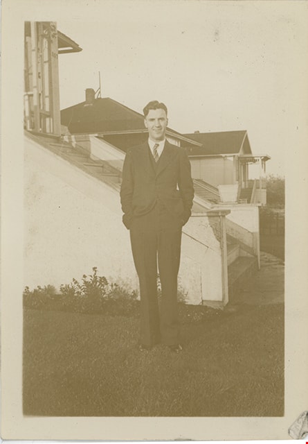
https://search.heritageburnaby.ca/link/museumdescription19427
- Repository
- Burnaby Village Museum
- Date
- 1936
- Collection/Fonds
- Hawkshaw family fonds
- Description Level
- Item
- Physical Description
- 1 photograph : sepia ; 9 x 6.5 cm
- Scope and Content
- Photograph of Crichton Hawkshaw dressed in a suit and standing in front of a house along a residential street.
- Repository
- Burnaby Village Museum
- Collection/Fonds
- Hawkshaw family fonds
- Description Level
- Item
- Physical Description
- 1 photograph : sepia ; 9 x 6.5 cm
- Scope and Content
- Photograph of Crichton Hawkshaw dressed in a suit and standing in front of a house along a residential street.
- Accession Code
- BV996.6.111
- Access Restriction
- No restrictions
- Reproduction Restriction
- No known restrictions
- Date
- 1936
- Media Type
- Photograph
- Scan Resolution
- 600
- Scan Date
- 2023-02-06
- Notes
- Title based on contents of photograph
- Caption beneath photograph reads: "Me 1936"
- Photograph is part of photograph album BV996.6.1
Images
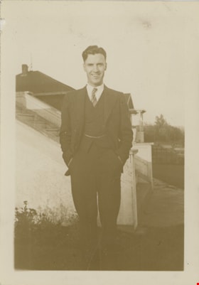
Crichton Hawkshaw
https://search.heritageburnaby.ca/link/museumdescription19430
- Repository
- Burnaby Village Museum
- Date
- 1936
- Collection/Fonds
- Hawkshaw family fonds
- Description Level
- Item
- Physical Description
- 1 photograph : sepia ; 9 x 6.5 cm
- Scope and Content
- Photograph of Crichton Hawkshaw dressed in a suit and standing in front of a house along a residential street.
- Repository
- Burnaby Village Museum
- Collection/Fonds
- Hawkshaw family fonds
- Description Level
- Item
- Physical Description
- 1 photograph : sepia ; 9 x 6.5 cm
- Scope and Content
- Photograph of Crichton Hawkshaw dressed in a suit and standing in front of a house along a residential street.
- Accession Code
- BV996.6.114
- Access Restriction
- No restrictions
- Reproduction Restriction
- No known restrictions
- Date
- 1936
- Media Type
- Photograph
- Scan Resolution
- 600
- Scan Date
- 2023-02-06
- Notes
- Title based on contents of photograph
- Caption beneath photograph reads: "Me"
- Photograph is part of photograph album BV996.6.1
Images
