Narrow Results By
Subject
- Advertising Medium - Signs and Signboards 8
- Agriculture - Crops 3
- Agriculture - Farms 1
- Armament 1
- Buildings - Civic - City Halls 1
- Buildings - Commercial 3
- Buildings - Commercial - Automobile Dealerships 1
- Buildings - Commercial - Drugstores 1
- Buildings - Commercial - Grocery Stores 2
- Buildings - Commercial - Restaurants 4
- Buildings - Commercial - Stores 2
- Buildings - Industrial 1
Creator
- Barrowclough, G.A. 1
- Burnett and McGugan B.C. Land Surveyors, New Westminster 5
- Burnett, Geoffrey K. 5
- Burnett & McGugan, Engineers and Surveyors 9
- Canadian Photo Company 1
- Dean, H.M. 1
- Garden, Hermon and Burwell 2
- Geoffrey K. Burnett 1
- Hill, Albert James 2
- John Reid 1
- McGugan, Donald Johnston 8
- Phillips, James William "Jim" 2
Person / Organization
- Anderson and Phillips Builders 1
- Armstrong Avenue School 1
- Barnet School 1
- Bennett, Eric Warrington Howard 1
- British Columbia Electric Railway 2
- British Columbia Electric Railway Company 1
- Burnaby City Hall 1
- Burnaby Village Museum 1
- Burnett, Geoffrey K. 2
- Central Park Agricultural Association and Farmers' Institute 1
- Central Park Provincial Park Board 1
- Donovan, George L. 1

Central Park Entrance Gate
https://search.heritageburnaby.ca/link/landmark544
- Repository
- Burnaby Heritage Planning
- Description
- The Central Park Entrance Gate is the ceremonial entrance to Burnaby’s historic Central Park from Kingsway, and consists of two massive stone pillars, approximately 7.5 metres high and 1.8 metres square, adjacent gate posts and a low flanking stone wall that curves into the park to the east.
- Associated Dates
- 1913
- Formal Recognition
- Heritage Designation, Community Heritage Register
- Street View URL
- Google Maps Street View
- Repository
- Burnaby Heritage Planning
- Geographic Access
- Imperial Street
- Associated Dates
- 1913
- Formal Recognition
- Heritage Designation, Community Heritage Register
- Enactment Type
- Bylaw No. 9807
- Enactment Date
- 23/11/1992
- Description
- The Central Park Entrance Gate is the ceremonial entrance to Burnaby’s historic Central Park from Kingsway, and consists of two massive stone pillars, approximately 7.5 metres high and 1.8 metres square, adjacent gate posts and a low flanking stone wall that curves into the park to the east.
- Heritage Value
- The Central Park Entrance Gate is significant as a ceremonial entry to a major park, for its connection with the early history of the British Columbia Electric Railway (BCER) and as an important design by an accomplished British Columbian architect. When the original interurban line between Vancouver and New Westminster was constructed in 1891, one of the first stations was located where the tramway crossed the Vancouver-Westminster Road (now Kingsway) within the newly-created Central Park. The interurban line ran through the park on a diagonal right-of-way (the current SkyTrain line, opened in 1986, follows this original alignment). In 1912 an agreement was reached between the successor interurban company, the BCER, and the Central Park Provincial Park Board, to deed additional land for an expanded right-of-way through the Park in exchange for improvements that included the construction of an ornamental stone wall and gate with an iron arch, with an illuminated 'Central Park' sign, adjacent to the interurban station on Kingsway. This was an early and rare example of an electric sign used for a public recreation facility. The Gate is also significant as a surviving early design by Robert Lyon (1879-1963), an Edinburgh-born and trained immigrant who was one of the most accomplished of British Columbia's early architects. After he moved to Vancouver, he was employed by the BCER from 1911 until 1918, and worked on a broad range of projects including some of the grandest and most innovative local industrial structures of the time. The arch was built by the Westminster Ironworks Company, one of the leading firms of its kind in Western Canada, operated by John Reid of New Westminster. The Gate was completed in 1914; in 1968 the decorative ironwork was removed due to corrosion and placed in storage.
- Defining Elements
- Key elements that define the heritage character of the Central Park Entrance Gate include its: - two subtly tapered massive stone pillars, which rise in stages from a larger base to a shaft with random coursed multi-coloured granite with roughly formed grey granite quoins, to a top formed of finely finished grey granite blocks with a coved and bracketed cap - adjacent gate posts with monolithic pyramidal granite caps - low flanking stone wall that curves into the park to the east, constructed of random coursed multi-coloured granite with a river rock triangular cap
- Historic Neighbourhood
- Central Park (Historic Neighbourhood)
- Planning Study Area
- Maywood Area
- Architect
- Robert Lyon
- Builder
- John Reid
- Westminster Iron Works Co.
- Function
- Primary Current--Park Fixture
- Primary Historic--Park Fixture
- Community
- Burnaby
- Cadastral Identifier
- P.I.D. No. 017-767-172 Legal Description: Block B of Lot 2 Except Firstly: Part on Plan 8669 and Secondly: Part on Plan LMP4689 District Lot 151, Group 1, New Westminster District, Plan 3443
- Boundaries
- The property (Central Park) is a municipally-owned park that lies at the western edge of Burnaby, between 49th Avenue to the south, Kingsway to the north, Boundary Road to the west and Patterson Avenue to the east.
- Area
- 853,403.82
- Contributing Resource
- Structure
- Landscape Feature
- Ownership
- Public (local)
- Names
- Lyon, Robert
- Reid, John
- Westminster Iron Works Company
- British Columbia Electric Railway Company
- Central Park Provincial Park Board
- Subjects
- Structures - Fences
- Street Address
- 3883 Imperial Street
- Street View URL
- Google Maps Street View
Images


Vorce Station
https://search.heritageburnaby.ca/link/landmark664
- Repository
- Burnaby Heritage Planning
- Description
- The Vorce Station is a modest utilitarian passenger tram shelter, originally constructed at the foot of Nursery Street as part of the British Columbia Electric Railway Company’s Burnaby Lake Interurban Line. In 1953, it was moved to a local farm by the Lubbock family, and in 1977 it was relocated t…
- Associated Dates
- 1911
- Formal Recognition
- Heritage Designation, Community Heritage Register
- Repository
- Burnaby Heritage Planning
- Geographic Access
- Deer Lake Avenue
- Associated Dates
- 1911
- Formal Recognition
- Heritage Designation, Community Heritage Register
- Enactment Type
- Bylaw No. 9807
- Enactment Date
- 23/11/1992
- Description
- The Vorce Station is a modest utilitarian passenger tram shelter, originally constructed at the foot of Nursery Street as part of the British Columbia Electric Railway Company’s Burnaby Lake Interurban Line. In 1953, it was moved to a local farm by the Lubbock family, and in 1977 it was relocated to Burnaby Village Museum. The wood-frame structure has a rectangular plan and hipped roof. It is enclosed on three sides, with an open side for access to the train platform and a single long built-in bench across the back of the station.
- Heritage Value
- The heritage value of the Vorce Station is as the last remaining interurban station in Burnaby and one of the few extant structures left in the Greater Vancouver region that were once part of the extensive British Columbia Electric Railway (BCER) interurban system. The Vorce Station was designed and built by the BCER, and is typical of the small local passenger stations on the Burnaby Lake and Chilliwack interurban lines. It was named after C.B. Vorce, the Chief Engineer for the company. The impact of the interurban line on local development was extremely significant, as it connected the cities of New Westminster and Vancouver, and enabled the residents of Burnaby to form a cohesive municipality from the mainly rural lands remaining between the two larger centres. Much of the early development in Burnaby was due to the growth of the interurban rail lines. The heritage significance for this station also lies in its interpretive value within the Burnaby Village Museum. The Vorce Station is an important cultural feature for the interpretation of Burnaby’s transportation history to the public, and is an important surviving feature of the BCER interurban system.
- Defining Elements
- The character defining features of the Vorce Station include its: - rectangular form and pyramidal roof with overhanging eaves - simple vernacular design and utilitarian nature - cedar shingle wall cladding - cedar shingle-clad roof with galvanized pressed tin roof ridges - interior vertical tongue-and-groove panelling - heritage graffiti: initials and messages carved and scrawled on the walls - identifying sign with large letters visible at a distance
- Locality
- Deer Lake Park
- Historic Neighbourhood
- Burnaby Lake (Historic Neighbourhood)
- Planning Study Area
- Morley-Buckingham Area
- Organization
- British Columbia Electric Railway
- Burnaby Village Museum
- Function
- Primary Current--Museum
- Primary Historic--Rail Station
- Community
- Burnaby
- Cadastral Identifier
- P.I.D. No. 011-030-356 Legal Description: Parcel 1, District Lot 79 and District Lot 85, Group 1, New Westminster District, Reference Plan 77594
- Boundaries
- Burnaby Village Museum is comprised of a single municipally-owned property located at 6501 Deer Lake Avenue, Burnaby.
- Area
- 38,488.63
- Contributing Resource
- Building
- Structure
- Landscape Feature
- Documentation
- Heritage Site Files: PC77000 20. City of Burnaby Planning and Building Department, 4949 Canada Way, Burnaby, B.C., V5G 1M2
- Street Address
- 6501 Deer Lake Avenue
Images


Thomas & Margaret Coldicutt Residence
https://search.heritageburnaby.ca/link/landmark647
- Repository
- Burnaby Heritage Planning
- Description
- Residential building.
- Associated Dates
- 1911
- Street View URL
- Google Maps Street View
- Repository
- Burnaby Heritage Planning
- Geographic Access
- 6th Street
- Associated Dates
- 1911
- Description
- Residential building.
- Heritage Value
- This house was built by Thomas Davis Coldicutt (1879-1970) and Margaret Jane Coldicutt, pre-eminent local citizens. Thomas Coldicutt was born in Birmingham and arrived in Canada in 1900, finding success in the steamboat industry. In 1902, he married Margaret Jane Styler who had been born in Redditch, Worcester, England, and in 1908 they settled in East Burnaby–some of the first pioneers to the area–and established a fruit farm. Thomas had a successful real estate, insurance and brokerage business, and was elected as a councillor for East Burnaby in 1909. He was also active in civic, political and social circles in Burnaby and became president of the Burnaby Board of Trade. "East Burnaby is booming and the signs of prosperity that may be seen on every hand. Most of these are substantial dwellings, such as effect a permanent improvement to the countryside. Among those whose homes have been completed, or on the point of completion may be mentioned. Councillor Coldicutt, who has built himself a habitation on Second Avenue at a cost of $4,000. (The British Columbian, 1911). In 1913, Coldicutt sold his original farm described as “the show place of Burnaby” to the Burnaby School Board for the development of Second Street School and this house was moved from Second Street and Sixteenth Avenue to this site. It has been extensively altered, but retains its original form, scale and massing.
- Locality
- East Burnaby
- Historic Neighbourhood
- East Burnaby (Historic Neighbourhood)
- Planning Study Area
- Edmonds Area
- Area
- 557.42
- Contributing Resource
- Building
- Ownership
- Private
- Street Address
- 7510 6th Street
- Street View URL
- Google Maps Street View
Images


![Barnet Road and North Avenue, [1914] thumbnail](/media/hpo/_Data/_BVM_Images/1971/197200110019.jpg?width=280)
Barnet Road and North Avenue
https://search.heritageburnaby.ca/link/museumdescription3105
- Repository
- Burnaby Village Museum
- Date
- [1914]
- Collection/Fonds
- Burnaby Village Museum Photograph collection
- Description Level
- Item
- Physical Description
- 1 photograph : b&w glass negative ; 16.0 x 20.9 cm
- Scope and Content
- Photograph of Barnet Road, a dirt road at the time of the photograph, from North Road. There is a sign post in the foreground to the left that indicates the crossing is "NORTH AVE" and "BARNET RD". On the sign post a provincial notice is tacked on. There are electric posts along one side of Barnet …
- Repository
- Burnaby Village Museum
- Collection/Fonds
- Burnaby Village Museum Photograph collection
- Description Level
- Item
- Physical Description
- 1 photograph : b&w glass negative ; 16.0 x 20.9 cm
- Scope and Content
- Photograph of Barnet Road, a dirt road at the time of the photograph, from North Road. There is a sign post in the foreground to the left that indicates the crossing is "NORTH AVE" and "BARNET RD". On the sign post a provincial notice is tacked on. There are electric posts along one side of Barnet Road, and further down the road is an unidentified man riding a motorcycle or a bicycle. According to an earlier catalogue record from 1988, the view is looking East, and the mountain rising in the background is Burnaby Mountain. The record also dates the negative ca. 1914
- Subjects
- Geographic Features - Roads
- Geographic Access
- Barnet Road
- North Road
- Accession Code
- HV972.11.19
- Access Restriction
- No restrictions
- Reproduction Restriction
- No known restrictions
- Date
- [1914]
- Media Type
- Photograph
- Planning Study Area
- Burnaby Mountain Area
- Scan Resolution
- 300
- Scan Date
- 14/8/2006
- Scale
- 100
- Notes
- Title based on contents of photograph
- 1 b&w contact print accompanying negative
Images
![Barnet Road and North Avenue, [1914] thumbnail](/media/hpo/_Data/_BVM_Images/1971/197200110019.jpg)

Central Park agricultural exhibit
https://search.heritageburnaby.ca/link/archivedescription34561
- Repository
- City of Burnaby Archives
- Date
- 1914
- Collection/Fonds
- Burnaby Historical Society fonds
- Description Level
- Item
- Physical Description
- 1 photograph : b&w ; 15.8 x 20.4 cm mounted on 25.3 x 30.2 cm cardboard
- Scope and Content
- Photograph of an exhibit of produce from Oakalla Prison Farm and the interior of Central Park Agricultural Hall. A sign above the display reads, "Produce from the Oakalla Prison Farm," and a sign to the left reads, "Not for competition."
- Repository
- City of Burnaby Archives
- Date
- 1914
- Collection/Fonds
- Burnaby Historical Society fonds
- Subseries
- Photographs subseries
- Physical Description
- 1 photograph : b&w ; 15.8 x 20.4 cm mounted on 25.3 x 30.2 cm cardboard
- Description Level
- Item
- Record No.
- 048-004
- Access Restriction
- No restrictions
- Reproduction Restriction
- No known restrictions
- Accession Number
- BHS2007-04
- Scope and Content
- Photograph of an exhibit of produce from Oakalla Prison Farm and the interior of Central Park Agricultural Hall. A sign above the display reads, "Produce from the Oakalla Prison Farm," and a sign to the left reads, "Not for competition."
- Names
- Oakalla Prison Farm
- Media Type
- Photograph
- Notes
- Title based on contents of photograph
- Geographic Access
- Central Park
- Imperial Street
- Street Address
- 3883 Imperial Street
- Historic Neighbourhood
- Central Park (Historic Neighbourhood)
- Planning Study Area
- Maywood Area
Images

![Kingsway at Salisbury Avenue, [1914] thumbnail](/media/hpo/_Data/_BVM_Images/1971/197200110005.jpg?width=280)
Kingsway at Salisbury Avenue
https://search.heritageburnaby.ca/link/museumdescription3091
- Repository
- Burnaby Village Museum
- Date
- [1914]
- Collection/Fonds
- Burnaby Village Museum Photograph collection
- Description Level
- Item
- Physical Description
- 1 photograph : b&w glass negative ; 16.0 x 20.9 cm
- Scope and Content
- Photograph of Kingsway looking west from Salisbury Avenue in Burnaby. At one corner of the four-way intersection is a road sign labelling the roads "Kingsway" and "Salisbury Ave," beside which hangs a "For Sale" sign from "Wolf Merton & Son" for a house at "119 Pender St. W. Vancouver." Across fro…
- Repository
- Burnaby Village Museum
- Collection/Fonds
- Burnaby Village Museum Photograph collection
- Description Level
- Item
- Physical Description
- 1 photograph : b&w glass negative ; 16.0 x 20.9 cm
- Scope and Content
- Photograph of Kingsway looking west from Salisbury Avenue in Burnaby. At one corner of the four-way intersection is a road sign labelling the roads "Kingsway" and "Salisbury Ave," beside which hangs a "For Sale" sign from "Wolf Merton & Son" for a house at "119 Pender St. W. Vancouver." Across from these signs stands a man in a suit beside one of the electric poles that lines Kingsway. Further behind him is a water tower that an earlier catalogue record from 1988 identifies as a Municipal Water Tower. Also, the record dates the negative ca. 1914.
- Subjects
- Geographic Features - Roads
- Structures - Water Tanks and Towers
- Public Services - Utilities
- Geographic Access
- Kingsway
- Salisbury Avenue
- Accession Code
- HV972.11.5
- Access Restriction
- No restrictions
- Reproduction Restriction
- No known restrictions
- Date
- [1914]
- Media Type
- Photograph
- Historic Neighbourhood
- Edmonds (Historic Neighbourhood)
- Planning Study Area
- Stride Avenue Area
- Richmond Park Area
- Scan Resolution
- 300
- Scan Date
- 14/8/2006
- Scale
- 100
- Notes
- Title based on contents of photograph
- 1 b&w contact print accompanying negative
Images
![Kingsway at Salisbury Avenue, [1914] thumbnail](/media/hpo/_Data/_BVM_Images/1971/197200110005.jpg)
![Model Grocery, [1914] (date of original), copied [1973] thumbnail](/media/hpo/_Data/_BVM_Images/1973/1973_0098_0001_001.jpg?width=280)
Model Grocery
https://search.heritageburnaby.ca/link/museumdescription3069
- Repository
- Burnaby Village Museum
- Date
- [1914] (date of original), copied [1973]
- Collection/Fonds
- Burnaby Village Museum Photograph collection
- Description Level
- Item
- Physical Description
- 1 photograph : b&w ; 20.1 x 25.1 cm print
- Scope and Content
- Photograph of Bill Hay (on left) and James Scott standing at the front entrance to the Model Grocery Store, situated at 2nd Street and 15th Avenue in Burnaby. The store has wooden shiplap siding all around and a peaked roof with a tall false front with a wide cornice at the top. The righthand side …
- Repository
- Burnaby Village Museum
- Collection/Fonds
- Burnaby Village Museum Photograph collection
- Description Level
- Item
- Physical Description
- 1 photograph : b&w ; 20.1 x 25.1 cm print
- Scope and Content
- Photograph of Bill Hay (on left) and James Scott standing at the front entrance to the Model Grocery Store, situated at 2nd Street and 15th Avenue in Burnaby. The store has wooden shiplap siding all around and a peaked roof with a tall false front with a wide cornice at the top. The righthand side of the eaves show, and the details of the gutter and downspout are clearly visible. The bottom front of the building is all one store. Display windows fill the front in three sections. On the extreme left and right are two wide windows. In the centre is another narrower window. Between these windows are two doors, set in about five feet. A canvas awning (furled) spans the store over the windows. Inside the windows, displays are visible. In the right hand window are stacks of tinned goods. In the centre, flats of fruit set up to face outwards. In the left window is a large display of White Swan soap. Below the right and left windows are small enamelled signs advertising Fleischman's Yeast. No other sign or advertising is visible on the exterior. In the right hand doorway is a display of washboard and corn brooms. A canvas covered horse drawn delivery wagon with a "308 6th St. Model Grocery" sign is positioned to the right rear of the store.
- Geographic Access
- 2nd Street
- 15th Avenue
- Accession Code
- HV973.98.1
- Access Restriction
- No restrictions
- Reproduction Restriction
- May be restricted by third party rights
- Date
- [1914] (date of original), copied [1973]
- Media Type
- Photograph
- Historic Neighbourhood
- East Burnaby (Historic Neighbourhood)
- Planning Study Area
- Second Street Area
- Related Material
- According to catalogue record from 1976, a taped interview with James Scott and Write up about the store are available in the BVM files.
- Scan Resolution
- 600
- Scan Date
- 2023-05-16
- Notes
- Title based on contents of photograph
- See HV973.98.2 for original negative associated with this copy print
- Related materials: According to a note with the photograph, a taped interview with James Scott (1975) and a write-up about this store are in the Burnaby Village Museum archives
Images
![Model Grocery, [1914] (date of original), copied [1973] thumbnail](/media/hpo/_Data/_BVM_Images/1973/1973_0098_0001_001.jpg)
![Vegetable display, [September 1914] thumbnail](/media/hpo/_Data/_BVM_Images/1971/197200110017.jpg?width=280)
Vegetable display
https://search.heritageburnaby.ca/link/museumdescription3103
- Repository
- Burnaby Village Museum
- Date
- [September 1914]
- Collection/Fonds
- Burnaby Village Museum Photograph collection
- Description Level
- Item
- Physical Description
- 1 photograph : b&w glass negative ; 16.4 x 21.3 cm
- Scope and Content
- Photograph of a vegetable display with a sign that reads, "GROWN FROM/ RENNIE'S/ SEEDS" and another sign indicating that the display is "Not for Competition/ Burnaby Production/ by/ Wm. Baily [illegible]". This is most likely at the 14th Annual Exhibition of the Central Park Agricultural Associati…
- Repository
- Burnaby Village Museum
- Collection/Fonds
- Burnaby Village Museum Photograph collection
- Description Level
- Item
- Physical Description
- 1 photograph : b&w glass negative ; 16.4 x 21.3 cm
- Scope and Content
- Photograph of a vegetable display with a sign that reads, "GROWN FROM/ RENNIE'S/ SEEDS" and another sign indicating that the display is "Not for Competition/ Burnaby Production/ by/ Wm. Baily [illegible]". This is most likely at the 14th Annual Exhibition of the Central Park Agricultural Association and Farmers' Institute that took place from 17th to 19th of September 1914. An earlier catalogue record from 1988 notes that the agricultural fair was held between 1902 to 1921 in the Central Park Agricultural Hall built in 1902 in Central Park on Kingsway and the B.C.E.R. tracks.
- Geographic Access
- Central Park
- Imperial Street
- Street Address
- 3883 Imperial Street
- Accession Code
- HV972.11.17
- Access Restriction
- No restrictions
- Reproduction Restriction
- No known restrictions
- Date
- [September 1914]
- Media Type
- Photograph
- Historic Neighbourhood
- Central Park (Historic Neighbourhood)
- Planning Study Area
- Maywood Area
- Related Material
- For another photograph of a vegetable display at the agricultural exhibition, see HV972.11.3. For a photograph of flower displays at the exhibition, see HV972.11.20
- Scan Resolution
- 300
- Scan Date
- 14/8/2006
- Scale
- 100
- Notes
- Title based on contents of photograph
- 1 b&w contact print accompanying copy negative
Images
![Vegetable display, [September 1914] thumbnail](/media/hpo/_Data/_BVM_Images/1971/197200110017.jpg)
![Anderson and Phillips Builders, [between 1910 and 1914] thumbnail](/media/hpo/_Data/_Archives_Images/_Unrestricted/487/487-029.jpg?width=280)
Anderson and Phillips Builders
https://search.heritageburnaby.ca/link/archivedescription57728
- Repository
- City of Burnaby Archives
- Date
- [between 1910 and 1914]
- Collection/Fonds
- J.W. Phillips fonds
- Description Level
- Item
- Physical Description
- 1 photograph : b&w glass negative ; 11 x 15.5 cm
- Scope and Content
- Photograph of a newly constructed house with land clearing debris and labourers working in the yard. A sign on the house reads; "Anderson and Phillips Builders", although the location and the specific individuals are unidentified (items no. 487-022 and 487-032 depict this house completed).
- Repository
- City of Burnaby Archives
- Date
- [between 1910 and 1914]
- Collection/Fonds
- J.W. Phillips fonds
- Physical Description
- 1 photograph : b&w glass negative ; 11 x 15.5 cm
- Material Details
- Emulsion measures 11 x 15.5 cm on the glass; entire glass plate measures 12 x 16 cm
- Description Level
- Item
- Record No.
- 487-029
- Access Restriction
- No restrictions
- Reproduction Restriction
- No known restrictions
- Accession Number
- 2008-18
- Scope and Content
- Photograph of a newly constructed house with land clearing debris and labourers working in the yard. A sign on the house reads; "Anderson and Phillips Builders", although the location and the specific individuals are unidentified (items no. 487-022 and 487-032 depict this house completed).
- Media Type
- Photograph
- Photographer
- Phillips, James William "Jim"
- Notes
- Title based on contents of photograph
Images
![Anderson and Phillips Builders, [between 1910 and 1914] thumbnail](/media/hpo/_Data/_Archives_Images/_Unrestricted/487/487-029.jpg)
![B.C. Parliament Building in Victoria, [ca. 1920] thumbnail](/media/hpo/_Data/_BVM_Images/1985/1985_5899_0003_001.jpg?width=280)
B.C. Parliament Building in Victoria
https://search.heritageburnaby.ca/link/museumdescription1527
- Repository
- Burnaby Village Museum
- Date
- [ca. 1920]
- Collection/Fonds
- Burnaby Village Museum Photograph collection
- Description Level
- Item
- Physical Description
- 1 photograph : b&w ; 6.5 x 9 cm
- Scope and Content
- Photograph of the British Columbia Parliament Buildings, home of the Legislative Assembly of British Columbia located in Victoria. There are people standing on the steps to the front entrance. There is a sign on the lawn in front of the parliament buliding that reads, "PLEASE KEEP OFF THE GRASS."
- Repository
- Burnaby Village Museum
- Collection/Fonds
- Burnaby Village Museum Photograph collection
- Description Level
- Item
- Physical Description
- 1 photograph : b&w ; 6.5 x 9 cm
- Material Details
- stamped on verso, t. "159"
- Scope and Content
- Photograph of the British Columbia Parliament Buildings, home of the Legislative Assembly of British Columbia located in Victoria. There are people standing on the steps to the front entrance. There is a sign on the lawn in front of the parliament buliding that reads, "PLEASE KEEP OFF THE GRASS."
- Subjects
- Government - Provincial Government
- Geographic Access
- Victoria
- Accession Code
- BV985.5899.3
- Access Restriction
- No restrictions
- Reproduction Restriction
- No known restrictions
- Date
- [ca. 1920]
- Media Type
- Photograph
- Scan Resolution
- 600
- Scan Date
- 2024-02-27
- Notes
- Title based on contents of photograph
Images
![B.C. Parliament Building in Victoria, [ca. 1920] thumbnail](/media/hpo/_Data/_BVM_Images/1985/1985_5899_0003_001.jpg)

Bob and Olive Urquhart beside Boundary Road
https://search.heritageburnaby.ca/link/archivedescription36759
- Repository
- City of Burnaby Archives
- Date
- March 19, 1913 (date of original), copied 1992
- Collection/Fonds
- Burnaby Historical Society fonds
- Description Level
- Item
- Physical Description
- 1 photograph : b&w ; 10 x 8 cm print
- Scope and Content
- Photograph of Bob and Olive Urquhart soon after their marriage, (they were married March 15). Note the new wood planking on Boundary Road and the train track crossing sign past the house in the distance for the Burnaby Lake Interurban tram line. This photograph was taken looking north on Boundary…
- Repository
- City of Burnaby Archives
- Date
- March 19, 1913 (date of original), copied 1992
- Collection/Fonds
- Burnaby Historical Society fonds
- Subseries
- Burnaby Centennial Anthology subseries
- Physical Description
- 1 photograph : b&w ; 10 x 8 cm print
- Description Level
- Item
- Record No.
- 315-114
- Access Restriction
- No restrictions
- Reproduction Restriction
- No known restrictions
- Accession Number
- BHS1994-04
- Scope and Content
- Photograph of Bob and Olive Urquhart soon after their marriage, (they were married March 15). Note the new wood planking on Boundary Road and the train track crossing sign past the house in the distance for the Burnaby Lake Interurban tram line. This photograph was taken looking north on Boundary Road just south of the railway tracks.
- Subjects
- Geographic Features - Roads
- Media Type
- Photograph
- Notes
- Title based on contents of photograph
- Geographic Access
- Boundary Road
- Myrtle Street
- Historic Neighbourhood
- Broadview (Historic Neighbourhood)
- Planning Study Area
- West Central Valley Area
Images


Burnaby Welcomes You
https://search.heritageburnaby.ca/link/archivedescription34051
- Repository
- City of Burnaby Archives
- Date
- 1912
- Collection/Fonds
- Burnaby Historical Society fonds
- Description Level
- Item
- Physical Description
- 1 photograph : b&w ; 7.7 x 12.4 cm mounted on cardboard
- Scope and Content
- Photograph of the welcome arch erected at Edmonds and Kingsway to welcome Prince Arthur, Duke of Connaught during his visit to Burnaby. Prince Arthur was Governor General of Canada at this time. The sign on the arch reads, "Burnaby Welcomes You."
- Repository
- City of Burnaby Archives
- Date
- 1912
- Collection/Fonds
- Burnaby Historical Society fonds
- Subseries
- Stride family subseries
- Physical Description
- 1 photograph : b&w ; 7.7 x 12.4 cm mounted on cardboard
- Description Level
- Item
- Record No.
- 001-027
- Access Restriction
- No restrictions
- Reproduction Restriction
- No known restrictions
- Accession Number
- BHS2007-04
- Scope and Content
- Photograph of the welcome arch erected at Edmonds and Kingsway to welcome Prince Arthur, Duke of Connaught during his visit to Burnaby. Prince Arthur was Governor General of Canada at this time. The sign on the arch reads, "Burnaby Welcomes You."
- Media Type
- Photograph
- Geographic Access
- Edmonds Street
- Kingsway
- Historic Neighbourhood
- Edmonds (Historic Neighbourhood)
- Planning Study Area
- Richmond Park Area
Images

![Carnarvon Street Building, [1912] thumbnail](/media/hpo/_Data/_Archives_Images/_Unrestricted/477/477-939.jpg?width=280)
Carnarvon Street Building
https://search.heritageburnaby.ca/link/archivedescription66213
- Repository
- City of Burnaby Archives
- Date
- [1912]
- Collection/Fonds
- Peers Family and Hill Family fonds
- Description Level
- Item
- Physical Description
- 1 photograph : sepia ; 19.5 x 24 cm
- Scope and Content
- Photograph of the Carnarvon Street building in New Westminster, built by Claude Hill and E. B. Wetenhall (architect). Three cars can be seen on the street, one with two unidentified men seated inside. A note on the back of the photograph indicates that the building in the background is the New We…
- Repository
- City of Burnaby Archives
- Date
- [1912]
- Collection/Fonds
- Peers Family and Hill Family fonds
- Physical Description
- 1 photograph : sepia ; 19.5 x 24 cm
- Description Level
- Item
- Record No.
- 477-939
- Access Restriction
- No restrictions
- Reproduction Restriction
- No known restrictions
- Accession Number
- 2007-12
- Scope and Content
- Photograph of the Carnarvon Street building in New Westminster, built by Claude Hill and E. B. Wetenhall (architect). Three cars can be seen on the street, one with two unidentified men seated inside. A note on the back of the photograph indicates that the building in the background is the New Westminster Opera House and a sign on the building in the foreground reads "Ford Cars - Fraser Valley Motor Co. Limited."
- Subjects
- Transportation - Automobiles
- Buildings - Commercial
- Buildings - Commercial - Automobile Dealerships
- Media Type
- Photograph
- Notes
- Title based on contents of photograph
- Note on verso reads: "Carnarvon St. Bldg. / built by L.C. Hill & EB Wetenhall (architect) / old New Westminster Opera House / r. background - / app. 1912 -"
Images
![Carnarvon Street Building, [1912] thumbnail](/media/hpo/_Data/_Archives_Images/_Unrestricted/477/477-939.jpg)

Central Park agricultural exhibit
https://search.heritageburnaby.ca/link/archivedescription34548
- Repository
- City of Burnaby Archives
- Date
- 1914
- Collection/Fonds
- Burnaby Historical Society fonds
- Description Level
- Item
- Physical Description
- 1 photograph : b&w ; 16.1 x 21.4 cm mounted on 25.1 x 30.1 cm cardboard
- Scope and Content
- Photograph of a vegetable exhibit and the interior of Central Park Agricultural Hall. A card accompanying the display reads in part, "Not for Competition / Burnaby [Production?] by Wm. Coulter [?]." Another sign reads, "Grown from Rennie's Seeds."
- Repository
- City of Burnaby Archives
- Date
- 1914
- Collection/Fonds
- Burnaby Historical Society fonds
- Subseries
- Photographs subseries
- Physical Description
- 1 photograph : b&w ; 16.1 x 21.4 cm mounted on 25.1 x 30.1 cm cardboard
- Description Level
- Item
- Record No.
- 044-008
- Access Restriction
- No restrictions
- Reproduction Restriction
- No known restrictions
- Accession Number
- BHS2007-04
- Scope and Content
- Photograph of a vegetable exhibit and the interior of Central Park Agricultural Hall. A card accompanying the display reads in part, "Not for Competition / Burnaby [Production?] by Wm. Coulter [?]." Another sign reads, "Grown from Rennie's Seeds."
- Media Type
- Photograph
- Notes
- Title based on contents of photograph
- Geographic Access
- Central Park
- Imperial Street
- Street Address
- 3883 Imperial Street
- Historic Neighbourhood
- Central Park (Historic Neighbourhood)
- Planning Study Area
- Maywood Area
Images


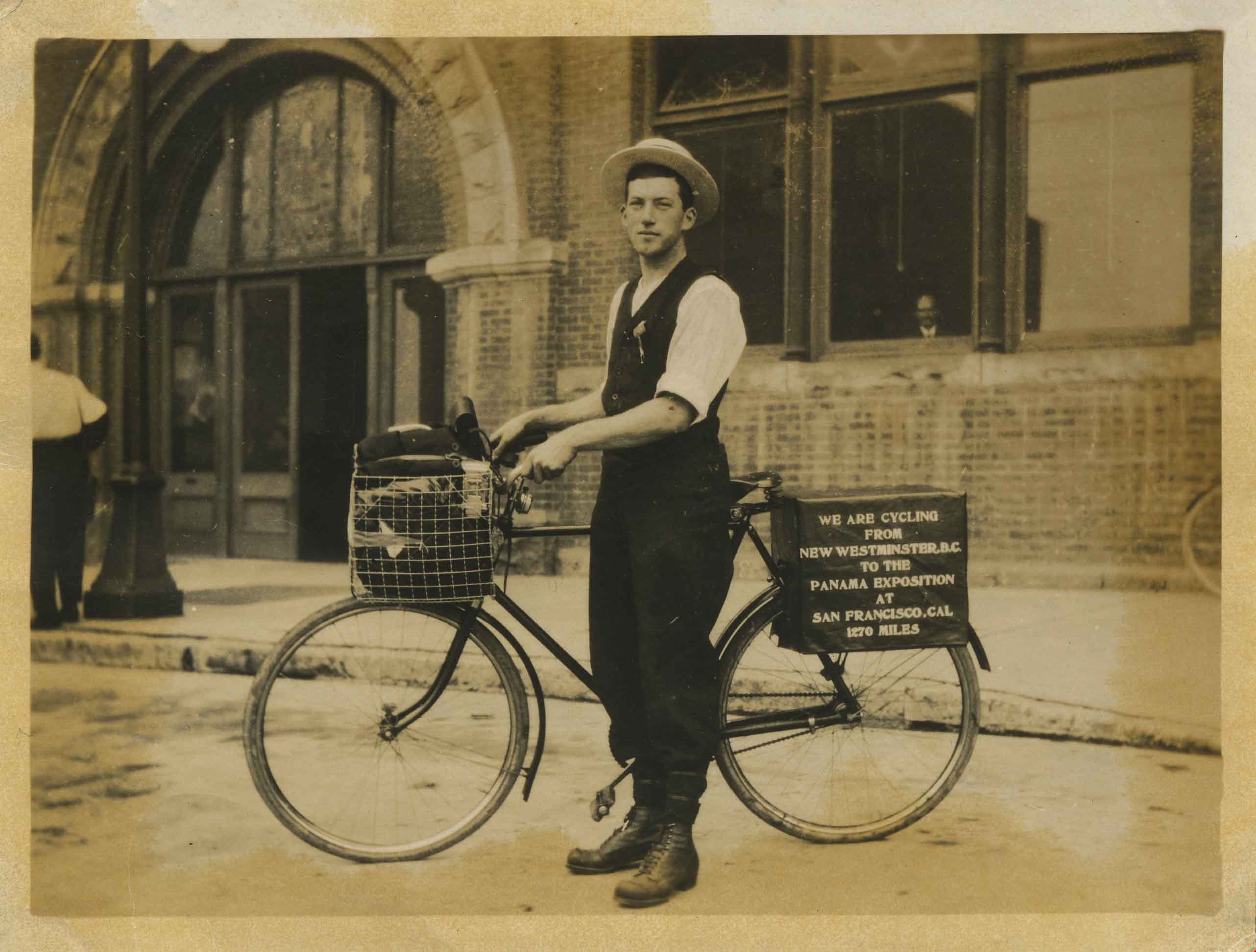
Charles Edgar Stride
https://search.heritageburnaby.ca/link/archivedescription34048
- Repository
- City of Burnaby Archives
- Date
- 1915
- Collection/Fonds
- Burnaby Historical Society fonds
- Description Level
- Item
- Physical Description
- 1 photograph : sepia ; 8.3 x 10.9 cm
- Scope and Content
- Photograph of Charles Edgar Stride on his bicycle at Columbia Street in New Westminster. The sign on his bicycle reads, "We are cycling from New Westminster BC to the Panama Exposition at San Francisco Cal. 1270 Miles."
- Repository
- City of Burnaby Archives
- Date
- 1915
- Collection/Fonds
- Burnaby Historical Society fonds
- Subseries
- Stride family subseries
- Physical Description
- 1 photograph : sepia ; 8.3 x 10.9 cm
- Description Level
- Item
- Record No.
- 001-024
- Access Restriction
- No restrictions
- Reproduction Restriction
- No known restrictions
- Accession Number
- BHS2007-04
- Scope and Content
- Photograph of Charles Edgar Stride on his bicycle at Columbia Street in New Westminster. The sign on his bicycle reads, "We are cycling from New Westminster BC to the Panama Exposition at San Francisco Cal. 1270 Miles."
- Subjects
- Transportation - Bicycles
- Names
- Stride, Charles Edgar
- Media Type
- Photograph
- Notes
- Title based on contents of photograph
Images
![Charlotte Vidal and unidentified man and woman, [between 1910 and 1920] thumbnail](/media/hpo/_Data/_Archives_Images/_Unrestricted/550/550-054.jpg?width=280)
Charlotte Vidal and unidentified man and woman
https://search.heritageburnaby.ca/link/archivedescription82439
- Repository
- City of Burnaby Archives
- Date
- [between 1910 and 1920]
- Collection/Fonds
- Hill family and Vidal family fonds
- Description Level
- Item
- Physical Description
- 1 photograph : b&w ; 8 x 11 cm
- Scope and Content
- Photograph is a portrait of Charlotte Vidal at far right with unidentified woman and man. Sign behind them reads: "Davies Druggist / wants your trade / Red Cross Pharmacy / C S Davies ... N Westminster / 52 sixth st"
- Repository
- City of Burnaby Archives
- Date
- [between 1910 and 1920]
- Collection/Fonds
- Hill family and Vidal family fonds
- Physical Description
- 1 photograph : b&w ; 8 x 11 cm
- Description Level
- Item
- Record No.
- 550-054
- Access Restriction
- No restrictions
- Reproduction Restriction
- No known restrictions
- Accession Number
- 2013-03
- Scope and Content
- Photograph is a portrait of Charlotte Vidal at far right with unidentified woman and man. Sign behind them reads: "Davies Druggist / wants your trade / Red Cross Pharmacy / C S Davies ... N Westminster / 52 sixth st"
- Media Type
- Photograph
- Notes
- Title based on contents of photograph
Images
![Charlotte Vidal and unidentified man and woman, [between 1910 and 1920] thumbnail](/media/hpo/_Data/_Archives_Images/_Unrestricted/550/550-054.jpg)
![Community along the bank of a creek, [between 1900 and 1915] thumbnail](/media/hpo/_Data/_BVM_Images/1971/197301100011.jpg?width=280)
Community along the bank of a creek
https://search.heritageburnaby.ca/link/museumdescription3080
- Repository
- Burnaby Village Museum
- Date
- [between 1900 and 1915]
- Collection/Fonds
- Burnaby Village Museum Photograph collection
- Description Level
- Item
- Physical Description
- 1 photograph : b&w glass negative
- Scope and Content
- Photograph of a stream with banks on both sides. There are power poles running along both sides of the stream and along the horizon. There are many houses forming a community to the left side of the stream in the photograph. On the right side of the photograph, there is a cabin with a large sign th…
- Repository
- Burnaby Village Museum
- Collection/Fonds
- Burnaby Village Museum Photograph collection
- Description Level
- Item
- Physical Description
- 1 photograph : b&w glass negative
- Scope and Content
- Photograph of a stream with banks on both sides. There are power poles running along both sides of the stream and along the horizon. There are many houses forming a community to the left side of the stream in the photograph. On the right side of the photograph, there is a cabin with a large sign that reads, "NEW ENGLAND GRANITE & MARBLE CO."
- Subjects
- Geographic Features - Creeks
- Accession Code
- HV973.110.11
- Access Restriction
- No restrictions
- Reproduction Restriction
- No known restrictions
- Date
- [between 1900 and 1915]
- Media Type
- Photograph
- Scan Resolution
- 300
- Scan Date
- 16/8/2006
- Scale
- 100
- Notes
- Title based on contents of photograph
- 1 b&w contact print accompanying negative
Images
![Community along the bank of a creek, [between 1900 and 1915] thumbnail](/media/hpo/_Data/_BVM_Images/1971/197301100011.jpg)
![Dow, Fraser and Company Limited, [1915] thumbnail](/media/hpo/_Data/_BVM_Images/1977/1977_0077_0001_001.jpg?width=280)
Dow, Fraser and Company Limited
https://search.heritageburnaby.ca/link/museumdescription551
- Repository
- Burnaby Village Museum
- Date
- [1915]
- Collection/Fonds
- Burnaby Village Museum Photograph collection
- Description Level
- Item
- Physical Description
- 1 photograph : sepia ; 16.5 x 21.5 cm photogravure
- Scope and Content
- Photograph of Mr. Eric Warrington Howard Bennett standing on the doorway to a store with large signs for a branch of Dow, Fraser & Co. Limited for real estate, loans, and fire insurance. The trust company is advertised on the sign as having been established in 1900. There is another store in the bu…
- Repository
- Burnaby Village Museum
- Collection/Fonds
- Burnaby Village Museum Photograph collection
- Description Level
- Item
- Physical Description
- 1 photograph : sepia ; 16.5 x 21.5 cm photogravure
- Scope and Content
- Photograph of Mr. Eric Warrington Howard Bennett standing on the doorway to a store with large signs for a branch of Dow, Fraser & Co. Limited for real estate, loans, and fire insurance. The trust company is advertised on the sign as having been established in 1900. There is another store in the building that is unidentified. Eric Warrington Howard Bennett was the branch manager of the Dow, Fraser company which started in Burnaby circa 1915. The store was located on the corner of McKay Avenue and the BC Electric Railway tracks. Later, a top storey was added to the building. An annotation on the back of the photograph reads: "Burnaby Branch Office. / E.W.H. Bennett / Manager."
- Geographic Access
- McKay Avenue
- Accession Code
- HV977.77.1
- Access Restriction
- No restrictions
- Reproduction Restriction
- No known restrictions
- Date
- [1915]
- Media Type
- Photograph
- Historic Neighbourhood
- Central Park (Historic Neighbourhood)
- Planning Study Area
- Maywood Area
- Scan Resolution
- 600
- Scan Date
- 2023-07-11
- Notes
- Title based on contents of photograph
Images
![Dow, Fraser and Company Limited, [1915] thumbnail](/media/hpo/_Data/_BVM_Images/1977/1977_0077_0001_001.jpg)
![Edmonds Street School class, [1918] thumbnail](/media/hpo/_Data/_Archives_Images/_Unrestricted/126/139-002.jpg?width=280)
Edmonds Street School class
https://search.heritageburnaby.ca/link/archivedescription34819
- Repository
- City of Burnaby Archives
- Date
- [1918]
- Collection/Fonds
- Burnaby Historical Society fonds
- Description Level
- Item
- Physical Description
- 1 photograph : b&w ; 9.2 x 20.3 cm
- Scope and Content
- Photograph of an Edmonds Street School class. Front row, left to right: Alfred Price, Percy Morrison, Walter Harris, Gardiner Mercer, Charlie Buskin, John Welsh, Dennis Burton, Einar Anderson, and Walter Hopkins. Middle row, left to right: Roddy Matheson, Martin Knudsen, Harold Colwell, Eric Wagst…
- Repository
- City of Burnaby Archives
- Date
- [1918]
- Collection/Fonds
- Burnaby Historical Society fonds
- Subseries
- Kathleen Moore family subseries
- Physical Description
- 1 photograph : b&w ; 9.2 x 20.3 cm
- Description Level
- Item
- Record No.
- 139-002
- Access Restriction
- No restrictions
- Reproduction Restriction
- No known restrictions
- Accession Number
- BHS1985-09
- Scope and Content
- Photograph of an Edmonds Street School class. Front row, left to right: Alfred Price, Percy Morrison, Walter Harris, Gardiner Mercer, Charlie Buskin, John Welsh, Dennis Burton, Einar Anderson, and Walter Hopkins. Middle row, left to right: Roddy Matheson, Martin Knudsen, Harold Colwell, Eric Wagstaff, Alvin Darrak, Katie McAskill, Marjorie Philips, Marjorie McFee, Annie McDonald, Johnnie McCallum, Sid Warne, Bill Culbert, Arthur Clark, and Jim Blair. Back row, left to right: Len Moxham, Bertha Chilten, [unidentified], Stella Yeadon, Eleanor Boyd, [unidentified], [first name unknown] Lewis, Harriet Hall, Nora Lewis, Mary Maxwell, Nora Coldicutt, and Sid Lamb. The teacher (not shown) was Helena Craik. A sign at the right side of the photograph reads, "Keys with Mr. Sutton, Cormary Ave."
- Names
- Edmonds Community School
- Media Type
- Photograph
- Notes
- Title based on contents of photograph
- Geographic Access
- Edmonds Street
- Street Address
- 7641 Edmonds Street
- Historic Neighbourhood
- Edmonds (Historic Neighbourhood)
- Planning Study Area
- Edmonds Area
Images
![Edmonds Street School class, [1918] thumbnail](/media/hpo/_Data/_Archives_Images/_Unrestricted/126/139-002.jpg)

Edmonds Triangle Block
https://search.heritageburnaby.ca/link/archivedescription38508
- Repository
- City of Burnaby Archives
- Date
- 1911
- Collection/Fonds
- Burnaby Historical Society fonds
- Description Level
- Item
- Physical Description
- 1 photograph: b&w postcard ; 8.5 x 14 cm
- Scope and Content
- Photographic postcard of the "triangle block" at Kingsway and Edmonds. The building housed stores, the post office, and Doctor Watson's apartment. Although the postcard bears no postmark, a note is written on the reverse which reads: "This is the new store at Edmonds. The shop at the end (before…
- Repository
- City of Burnaby Archives
- Date
- 1911
- Collection/Fonds
- Burnaby Historical Society fonds
- Subseries
- Photographs subseries
- Physical Description
- 1 photograph: b&w postcard ; 8.5 x 14 cm
- Description Level
- Item
- Record No.
- 449-003
- Access Restriction
- No restrictions
- Reproduction Restriction
- No known restrictions
- Accession Number
- BHS2007-04
- Scope and Content
- Photographic postcard of the "triangle block" at Kingsway and Edmonds. The building housed stores, the post office, and Doctor Watson's apartment. Although the postcard bears no postmark, a note is written on the reverse which reads: "This is the new store at Edmonds. The shop at the end (before it was opened) where the man is outside is the Post Office. Round the other side is a cafe, and upstairs we a Doctor living." A sign on the building reads "Edmonds General Store Co." and three unidentified people can be seen standing on the steps. In the foreground, the streetcar lines can be seen.
- Media Type
- Photograph
- Notes
- Title based on contents of photograph
- Geographic Access
- Edmonds Street
- Kingsway
- Street Address
- 7338 Kingsway
- Historic Neighbourhood
- Edmonds (Historic Neighbourhood)
- Planning Study Area
- Edmonds Area
Images
