More like 'Simon Fraser University Buildings'
Narrow Results By
Decade
- 2020s 120
- 2010s 118
- 2000s 673
- 1990s 664
- 1980s 504
- 1970s 1062
- 1960s 440
- 1950s 563
- 1940s 667
- 1930s
- 1920s 720
- 1910s
- 1900s 304
- 1890s 52
- 1880s 79
- 1870s 7
- 1860s 5
- 1850s 3
- 1840s 1
- 1830s 2
- 1820s 1
- 1810s 1
- 1800s 1
- 1790s 1
- 1780s 1
- 1770s 1
- 1760s 1
- 1750s 1
- 1740s 1
- 1730s 1
- 1720s 1
- 1710s 1
- 1700s 1
- 1690s 1
- 1680s 1
- 1670s 1
- 1660s 1
- 1650s 1
- 1640s 1
- 1630s 1
- 1620s 1
- 1610s 1
- 1600s 1
Subject
- Advertising Medium 1
- Advertising Medium - Signs and Signboards 11
- Aerial Photographs 2
- Agricultural Tools and Equipment - Gardening Equipment 4
- Agricultural Tools and Equipment - Plows 3
- Agriculture 1
- Agriculture - Crops 2
- Agriculture - Dairy 1
- Agriculture - Farms 19
- Agriculture - Fruit and Berries 1
- Animals - Birds 2
- Animals - Cats 2
Creator
- Baldwin, Sara E. (Sara Emily) 1
- Barrowclough, G.A. 1
- BC Photo Card Company 1
- Beatty Bros Limited 1
- Bellinger, Bernard 13
- British Columbia. Department of Education 1
- Brown, Conway 1
- Brown, W. 1
- Brown, William Thomas 1
- Burnaby Village Museum 8
- Burnett and McGugan B.C. Land Surveyors, New Westminster 5
- Burnett, Geoffrey K. 3

Duncan & Margaret McGregor Estate 'Glen-Lyon' New Haven Barn
https://search.heritageburnaby.ca/link/landmark852
- Repository
- Burnaby Heritage Planning
- Description
- Designed in a vernacular architectural style, the New Haven Barn is a large gambrel-roofed barn located on the Edwardian era McGregor Estate 'Glen-Lyon,' overlooking the rich farmland of the Fraser River floodplain and near a ravine and forested area adjacent to Marine Drive in South Burnaby.
- Associated Dates
- 1939
- Formal Recognition
- Heritage Designation, Community Heritage Register
- Other Names
- Home of the Friendless, New Haven Borstal Home for Boys and Youthful Offenders, New Haven Correction Centre
- Street View URL
- Google Maps Street View
- Repository
- Burnaby Heritage Planning
- Other Names
- Home of the Friendless, New Haven Borstal Home for Boys and Youthful Offenders, New Haven Correction Centre
- Geographic Access
- Marine Drive
- Associated Dates
- 1939
- Formal Recognition
- Heritage Designation, Community Heritage Register
- Enactment Type
- Bylaw No. 12183
- Enactment Date
- 11/12/2006
- Description
- Designed in a vernacular architectural style, the New Haven Barn is a large gambrel-roofed barn located on the Edwardian era McGregor Estate 'Glen-Lyon,' overlooking the rich farmland of the Fraser River floodplain and near a ravine and forested area adjacent to Marine Drive in South Burnaby.
- Heritage Value
- The site is historically significant for its association with early social welfare and correctional reform. The estate was sold in 1926 to an inter-denominational religious organization called the Home of the Friendless, which used it as their B.C. headquarters. The organization was charged with several cases of abuse and neglect in 1937, after which a Royal Commission was formed that led to new legislation to regulate and license all private welfare institutions. 'Glen-Lyon' was sold to the provincial government, and was dedicated in 1939 by the Lt.-Gov. E.W. Hamber for use as the New Haven Borstal Home for Boys and Youthful Offenders (later renamed the New Haven Correction Centre). The Borstal movement originated in England in the late nineteenth century, as an alternative to sending young offenders and runaways to prisons by providing reformatories that focused on discipline and vocational skill. This site’s role as the first North American institution devoted to the Borstal School philosophy was historic, and influenced corrections programs across Canada. The New Haven Barn is a significant feature from its development in 1939 as the Borstal School, designed by Chief Provincial Architect Henry Whittaker of the Department of Public Works, and is the only remaining structure of its kind in Burnaby.
- Defining Elements
- Key elements that define the heritage character of the New Haven Barn include its: - gambrel-roofed barn with roof vent with finial, sliding hay loft and access doors, small multi-pane windows, and lapped wooden siding
- Historic Neighbourhood
- Fraser Arm (Historic Neighbourhood)
- Planning Study Area
- Big Bend Area
- Architect
- Henry Whittaker
- Function
- Primary Historic--Estate
- Community
- Burnaby
- Cadastral Identifier
- 003-004-661
- Boundaries
- 'Glen-Lyon' is comprised of a single residential lot located at 4250 Marine Drive, Burnaby.
- Area
- 230873.18
- Contributing Resource
- Building
- Ownership
- Private
- Names
- Whittaker, George
- New Haven Borstal Home for Boys and Youthful Offenders
- New Haven Correction Centre
- Borstal School
- Street Address
- 4250 Marine Drive
- Street View URL
- Google Maps Street View
Images


Edmonds Baptist Church
https://search.heritageburnaby.ca/link/landmark575
- Repository
- Burnaby Heritage Planning
- Description
- Church building.
- Associated Dates
- 1912
- Street View URL
- Google Maps Street View
- Repository
- Burnaby Heritage Planning
- Geographic Access
- Walker Avenue
- Associated Dates
- 1912
- Description
- Church building.
- Heritage Value
- Beautifully designed in an Arts and Crafts idiom, this church features a textural mix of finishes including lapped siding and stucco and half timbering in the gables. The British Columbian reported in July 1912 that: "The Baptists of Edmonds will possess a fine and well planned church when the building now commenced is ready for occupation. The architects are J.P. Matheson and Son, of Vancouver, and the contractors, Muttitt and Bell, of New Westminster. The entrance porch fronts Edmonds Road and the west side faces Vancouver Road. It will have a capacity for 272 sittings, spacious aisles and choir platform besides various rooms for Baptistery, vestry and robing apartments."
- Locality
- Edmonds
- Historic Neighbourhood
- Edmonds (Historic Neighbourhood)
- Planning Study Area
- Richmond Park Area
- Architect
- J.P. Matheson & Son
- Builder
- Muttitt and Bell
- Area
- 1471.58
- Contributing Resource
- Building
- Ownership
- Private
- Names
- Matheson, John
- Street Address
- 7135 Walker Avenue
- Street View URL
- Google Maps Street View
Images


H.T. Ceperley Estate 'Fairacres' Mansion
https://search.heritageburnaby.ca/link/landmark526
- Repository
- Burnaby Heritage Planning
- Description
- 'Fairacres' is a large, two-and-one-half storey estate house in the British Arts and Crafts style, located in Deer Lake Park, with four associated original outbuildings.
- Associated Dates
- 1911
- Formal Recognition
- Heritage Designation, Community Heritage Register
- Other Names
- Henry Tracy & Grace Ceperley Estate
- Burnaby Art Gallery
- Street View URL
- Google Maps Street View
- Repository
- Burnaby Heritage Planning
- Other Names
- Henry Tracy & Grace Ceperley Estate
- Burnaby Art Gallery
- Geographic Access
- Deer Lake Avenue
- Associated Dates
- 1911
- Formal Recognition
- Heritage Designation, Community Heritage Register
- Enactment Type
- Bylaw No. 9807
- Enactment Date
- 23/11/1992
- Description
- 'Fairacres' is a large, two-and-one-half storey estate house in the British Arts and Crafts style, located in Deer Lake Park, with four associated original outbuildings.
- Heritage Value
- 'Fairacres' is important as a record of the early years of Burnaby, specifically the Deer Lake area, as a place of tranquility and beautiful scenery in which the wealthy and successful in the burgeoning cities of New Westminster and Vancouver chose to retire or to make their family homes. The main house, which anchors in style and setting the outbuildings on the estate, demonstrates the social, cultural, and aesthetic values of local wealthy businessmen and women of the early twentieth century - values such as appreciation of architectural elegance and grand interior spaces, leisure and recreation, formal landscaped gardens and scenic views. Also important is the association with the English-born and trained architect Robert Mackay Fripp (1858-1917), as this was one of his grandest residential commissions. Steeped in the current architectural trends in Great Britain, Fripp designed this sprawling mansion in the Arts and Crafts style, reflected in the architectural detailing and proportions. The style was common at the time and was often used for estate mansions as a symbol of affluence and good, modern taste as well as an affinity for all things British. Quality is displayed inside and out in the finishes and materials, orchestrated by prominent local contractor, James Charles Allen, including imported English materials of specific value such as imported Medmenham tiles in the fireplace surrounds, one of the earliest documented use of these tiles outside the United Kingdom. Detailed features of the interior woodwork were carved by Scottish-born master wood carver George Selkirk Gibson (1867-1942), who was best known for his many commissions for prominent British Columbia architect Samuel Maclure. The outbuildings at 'Fairacres' are an important record of the functioning of a large estate of the time. The Garage and Stables and the Chauffeur’s Cottage accommodated the use of automobiles, horses and carriages, and in concert with the estate's location near the new British Columbia Electric Railway 'Burnaby Lake' interurban line, illustrate the evolving nature of regional transportation and the growing bedroom communities and estates made possible by increasing options for transportation. Other outbuildings accommodated the agricultural activities that helped support the Ceperley estate. The estate was conceived and funded by American-born Grace E. Dixon Ceperley (1863-1917), who had achieved significant wealth through a bequest from her brother-in-law, Vancouver pioneer Arthur Ferguson. Her husband, Henry Tracy Ceperley (1850-1929), also American-born, was a successful and well-respected businessman who made a significant contribution to the development of the City of Vancouver. The construction of 'Fairacres' spawned the transformation of the Deer Lake area from a farming community into a preferred location for elite suburban homes. 'Fairacres' is significant to the City of Burnaby as its first civic heritage conservation project. Acquired in 1966 for conversion to Burnaby’s first art gallery, it was dedicated in 1967 to mark Canada’s Centennial of Confederation.
- Defining Elements
- Key elements that define the heritage character of the ‘Fairacres’ mansion include its: - setting in relation to the gardens, its former market garden, and the vistas to Deer Lake and other grand homes in the area - side gable roof with prominent dormers and cedar shingle cladding - verandah across the eastern (garden) facade, with its view over the landscaped gardens and the distant mountains - porte cochere with its side steps for those arriving by automobile, and central raised step for those alighting from horse-drawn carriages - rich variety of exterior elements that demonstrate the typical Arts and Crafts use of local materials such as cobble stone chimneys and foundations, wide wooden siding and half-timbering - mixture of double-hung and casement wooden-sash windows, many with multi-paned sash - lavish interior spaces, designed for entertaining on a grand scale, including a billiard room with a beamed ceiling and an inglenook fireplace, and generous living and dining rooms arranged off a central hall - quality of the interior materials such as imported Medmenham tiles in fireplace surrounds, window hardware by Hope and Sons, and leaded stained glass - interior wood work including the staircase, and carvings by George Selkirk Gibson - remaining formal Edwardian garden landscape elements, including the cross-axial plan that reflects the relationship of the mansion to its 'outdoor rooms'
- Locality
- Deer Lake Park
- Historic Neighbourhood
- Burnaby Lake (Historic Neighbourhood)
- Planning Study Area
- Douglas-Gilpin Area
- Architect
- Robert Mackay Fripp
- Function
- Primary Current--Museum
- Primary Historic--Estate
- Community
- Burnaby
- Cadastral Identifier
- P.I.D. No. 004-493-311 Legal Description: Block 3 Except: Part subdivided by Plan 26865, District Lot 79, Group 1, New Westminster District, Plan 536
- Boundaries
- ‘Fairacres’ is comprised of a single municipally-owned property located at 6344 Deer Lake Avenue, Burnaby.
- Area
- 17,065.00
- Contributing Resource
- Building
- Landscape Feature
- Ownership
- Public (local)
- Other Collection
- City of Burnaby, Visual Art Collection: Original rendering by R.P.S. Twizell Burnaby Historical Society, Community Archives: Ceperley Photograph Album Burnaby Village Museum, Collection: Carved dining room panels by G.S. Gibson and other hardware items
- Documentation
- Heritage Site Files: PC77000 20. City of Burnaby Planning and Building Department, 4949 Canada Way, Burnaby, B.C., V5G 1M2
- Names
- Ceperley, Grace
- Ceperley, H.T.
- Fripp, Robert Mackay
- Allen, James Charles
- Gibson, George Selkirk
- Street Address
- 6344 Deer Lake Avenue
- Street View URL
- Google Maps Street View
Images


H.T. Ceperley Estate 'Fairacres' Chauffeur's Cottage
https://search.heritageburnaby.ca/link/landmark529
- Repository
- Burnaby Heritage Planning
- Description
- Designed in the British Arts and Crafts style, the Chauffeur's Cottage is situated across from the main entrance to the Ceperley Mansion, and adjacent to the Garage and Stables. A long, narrow single-storey building, it was constructed by joining together two modest estate cottages.
- Associated Dates
- 1911
- Formal Recognition
- Heritage Designation, Community Heritage Register
- Repository
- Burnaby Heritage Planning
- Geographic Access
- Deer Lake Avenue
- Associated Dates
- 1911
- Formal Recognition
- Heritage Designation, Community Heritage Register
- Enactment Type
- Bylaw No. 9807
- Enactment Date
- 23/11/1992
- Description
- Designed in the British Arts and Crafts style, the Chauffeur's Cottage is situated across from the main entrance to the Ceperley Mansion, and adjacent to the Garage and Stables. A long, narrow single-storey building, it was constructed by joining together two modest estate cottages.
- Heritage Value
- The outbuildings at 'Fairacres' are a rare surviving architecturally designed ensemble of agricultural structures that exist in complementary harmony with the main estate house. Architect Robert Mackay Fripp (1858-1917) was retained by the Ceperleys to design several original outbuildings on their estate at the same time as the main house was constructed. The Chauffeur's Cottage illustrates the increasing importance of the automobile in the lives of the wealthy of the early twentieth century. It also demonstrates Grace and Henry Tracy Ceperley's social aspirations and grand-country-estate pretension in having a chauffeur. The cottage's location - close to the garage and convenient, but not adjacent, to the main house - enhances the grand country house landscape design and contributes to the overall composition of the estate's plan. The Arts and Crafts styled Chauffeur's Cottage is important as an indicator of the aesthetic and social sensibilities of the Ceperley family in retaining an architect to design a modest building for staff accommodation.
- Defining Elements
- Key elements that define the heritage character of the 'Fairacres' Chauffeur's Cottage include its: - location, in relation to the main house and in close proximity to the Garage and Stables buildings - side gable roof with cedar shingle cladding - Arts and Crafts architectural features such as the jerkin-headed door hood, a reference to the thatched-roofed cottages of southern England; eight-paned wooden-sash casement windows; and cedar-shingled exterior - two internal brick chimneys - modest, functional interior, with simple trim and lack of pretension
- Locality
- Deer Lake Park
- Historic Neighbourhood
- Burnaby Lake (Historic Neighbourhood)
- Planning Study Area
- Douglas-Gilpin Area
- Architect
- Robert Mackay Fripp
- Function
- Primary Historic--Outbuilding
- Community
- Burnaby
- Cadastral Identifier
- P.I.D. No. 004-493-311 Legal Description: Block 3 Except: Part subdivided by Plan 26865, District Lot 79, Group 1, New Westminster District, Plan 536
- Boundaries
- ‘Fairacres’ is comprised of a single municipally-owned property located at 6344 Deer Lake Avenue, Burnaby.
- Area
- 17,065.00
- Contributing Resource
- Building
- Landscape Feature
- Ownership
- Public (local)
- Other Collection
- Burnaby Historical Society, Community Archives: Ceperley Photograph Album Burnaby Village Museum, Collection: Chinese ‘Tiger Whiskey’ and opium bottles found during restoration
- Documentation
- Heritage Site Files: PC77000 20. City of Burnaby Planning and Building Department, 4949 Canada Way, Burnaby, B.C., V5G 1M2
- Street Address
- 6344 Deer Lake Avenue
Images


H.T. Ceperley Estate 'Fairacres' Garage & Stables
https://search.heritageburnaby.ca/link/landmark530
- Repository
- Burnaby Heritage Planning
- Description
- Designed in the British Arts and Crafts style, the ‘Fairacres’ Garage and Stables is a two-storey wood frame building located on the 'Fairacres' estate, situated to the north of the Chauffeur's Cottage; at the south end of the structure is a single vehicle garage and to the north are several stable…
- Associated Dates
- 1911
- Formal Recognition
- Heritage Designation, Community Heritage Register
- Street View URL
- Google Maps Street View
- Repository
- Burnaby Heritage Planning
- Geographic Access
- Deer Lake Avenue
- Associated Dates
- 1911
- Formal Recognition
- Heritage Designation, Community Heritage Register
- Enactment Type
- Bylaw No. 9807
- Enactment Date
- 23/11/1992
- Description
- Designed in the British Arts and Crafts style, the ‘Fairacres’ Garage and Stables is a two-storey wood frame building located on the 'Fairacres' estate, situated to the north of the Chauffeur's Cottage; at the south end of the structure is a single vehicle garage and to the north are several stables for carriage, riding, and draught horses, a coach house, and tack room; the upper floor was originally a hay loft.
- Heritage Value
- The outbuildings at 'Fairacres' are a rare surviving architecturally designed ensemble of agricultural structures that exist in complementary harmony with the main estate house. Architect Robert Mackay Fripp (1858-1917) was retained by the Ceperleys to design several original outbuildings on their estate at the same time as the main house was constructed. The Garage and Stables building is important as a record of its era when transportation modes were in transition and the horse-drawn carriage, while still in use, was giving way to the automobile. The relative spatial arrangements within the building are a valuable indication of the economy of space associated with the automobile, as compared to the horse. The extent of the stabling arrangements signifies not only the use of carriage horses but also the continued reliance on draught horses in farming activities in this era. As well, it is an indication of the fashionable nature of equestrianism for wealthy families during this time. The building is important as a demonstration of the aesthetics of the Ceperley family in having an architect-designed outbuilding and obtaining craftsmanship and materials of the highest quality for each structure on their estate.
- Defining Elements
- Key elements that define the heritage character of the 'Fairacres' Garage and Stables include its: - location within easy reach of the main house and in close proximity to the Chauffeur's Cottage - floor plan with the garage at one end, close to the Chauffeur's Cottage, and stables and equine facilities at the other - variety and complexity of the roofline, including gable wall dormers, gable-on-hip roof ends, and half-hip extensions - Arts and Crafts architectural features of the exterior such as the shingle wall cladding articulated with a chevron-patterned course of shingles at the first floor level; casement windows; and deep eaves with additional purlins to support the overhang - original stable doors with hand-made forged-iron door hardware - multi-paned wooden-sash windows, some retaining original wire glass
- Locality
- Deer Lake Park
- Historic Neighbourhood
- Burnaby Lake (Historic Neighbourhood)
- Planning Study Area
- Douglas-Gilpin Area
- Architect
- Robert Mackay Fripp
- Function
- Primary Historic--Outbuilding
- Community
- Burnaby
- Cadastral Identifier
- P.I.D. No. 004-493-311 Legal Description: Block 3 Except: Part subdivided by Plan 26865, District Lot 79, Group 1, New Westminster District, Plan 536
- Boundaries
- ‘Fairacres’ is comprised of a single municipally-owned property located at 6344 Deer Lake Avenue, Burnaby.
- Area
- 17,065.00
- Contributing Resource
- Building
- Landscape Feature
- Ownership
- Public (local)
- Other Collection
- Burnaby Historical Society, Community Archives: Ceperley Photograph Album
- Documentation
- Heritage Site Files: PC77000 20. City of Burnaby Planning and Building Department, 4949 Canada Way, Burnaby, B.C., V5G 1M2
- Street Address
- 6344 Deer Lake Avenue
- Street View URL
- Google Maps Street View
Images


![Douglas Road, Burnaby, [1908] thumbnail](/media/hpo/_Data/_Archives_Images/_Unrestricted/371/449-009.jpg?width=280)
Douglas Road, Burnaby
https://search.heritageburnaby.ca/link/archivedescription38514
- Repository
- City of Burnaby Archives
- Date
- [1908]
- Collection/Fonds
- Burnaby Historical Society fonds
- Description Level
- Item
- Physical Description
- 1 photograph : sepia postcard ; 8.8 x 14 cm
- Scope and Content
- Photographic postcard taken looking northwest along Douglas Road (now Canada Way) near Stanley Street. Two unidentified people are standing next to a wooden fence running alongside the road (above Lubbock's Creek) and a number of houses (including the Sprott house) are visible in the background. To…
- Repository
- City of Burnaby Archives
- Date
- [1908]
- Collection/Fonds
- Burnaby Historical Society fonds
- Subseries
- Photographs subseries
- Physical Description
- 1 photograph : sepia postcard ; 8.8 x 14 cm
- Description Level
- Item
- Record No.
- 449-009
- Access Restriction
- No restrictions
- Reproduction Restriction
- No known restrictions
- Accession Number
- BHS2007-04
- Scope and Content
- Photographic postcard taken looking northwest along Douglas Road (now Canada Way) near Stanley Street. Two unidentified people are standing next to a wooden fence running alongside the road (above Lubbock's Creek) and a number of houses (including the Sprott house) are visible in the background. To the right is Burnaby Lake. Stamped at the top of the postcard is "Douglas Road, Burnaby / New Westminster BC."
- Subjects
- Geographic Features - Lakes and Ponds
- Documentary Artifacts - Postcards
- Geographic Features - Roads
- Media Type
- Photograph
- Geographic Access
- Douglas Road
- Stanley Street
- Canada Way
- Deer Lake
- Historic Neighbourhood
- Burnaby Lake (Historic Neighbourhood)
- Planning Study Area
- Lakeview-Mayfield Area
Images
![Douglas Road, Burnaby, [1908] thumbnail](/media/hpo/_Data/_Archives_Images/_Unrestricted/371/449-009.jpg)

Neville Street by Royal Oak
https://search.heritageburnaby.ca/link/museumdescription3031
- Repository
- Burnaby Village Museum
- Date
- 1912
- Collection/Fonds
- Burnaby Village Museum Photograph collection
- Description Level
- Item
- Physical Description
- 1 photograph : sepia postcard ; 8.8 x 13.9 cm
- Scope and Content
- Photographic postcard of Neville Street just off Royal Oak Avenue. The street is a dirt road lined with residential buildings on one side and eletric power poles on the other side. The Holdsworth house is seen being constructed on the left. There is scaffolding on the side of the building and a cle…
- Repository
- Burnaby Village Museum
- Collection/Fonds
- Burnaby Village Museum Photograph collection
- Description Level
- Item
- Physical Description
- 1 photograph : sepia postcard ; 8.8 x 13.9 cm
- Scope and Content
- Photographic postcard of Neville Street just off Royal Oak Avenue. The street is a dirt road lined with residential buildings on one side and eletric power poles on the other side. The Holdsworth house is seen being constructed on the left. There is scaffolding on the side of the building and a cleared lot beside the house. here are variant spellings of "Holdsworth" used in the notes in the accession file. They are "Houldsworth" and "Hallsworth." The 1937 British Columbia directory lists a Fred Houldsworth at 3345 Neville Street, Burnaby. The address was later renumbered 5249 Neville Street. An annotation on the back of the postcard reads: "Nevil [sic] Street - 1912 - Just off Royal Oak."
- Subjects
- Buildings - Residential - Houses
- Documentary Artifacts - Postcards
- Geographic Features - Roads
- Geographic Access
- Neville Street
- Royal Oak Avenue
- Accession Code
- HV980.12.3
- Access Restriction
- No restrictions
- Reproduction Restriction
- May be restricted by third party rights
- Date
- 1912
- Media Type
- Photograph
- Historic Neighbourhood
- Alta-Vista (Historic Neighbourhood)
- Planning Study Area
- Clinton-Glenwood Area
- Scan Resolution
- 600
- Scan Date
- 2023-09-12
- Notes
- Title based on contents of photograph
Images

![Some of Our Homes, Barnet, [1912] thumbnail](/media/Hpo/_Data/_Archives_Images/_Unrestricted/001/015-014.jpg?width=280)
Some of Our Homes, Barnet
https://search.heritageburnaby.ca/link/archivedescription39782
- Repository
- City of Burnaby Archives
- Date
- [1912]
- Collection/Fonds
- Burnaby Historical Society fonds
- Description Level
- Item
- Physical Description
- 1 photograph : b&w postcard ; 8.5 x 13.8 cm
- Scope and Content
- Photograph on a postcard shows row of houses along a street at Barnet Village. The postcard is postmarked July 30, 1912, Barnet, from Evelyn, who had travelled to Barnet, to her mother, Mrs. John Laity in Port Hammond, BC.
- Repository
- City of Burnaby Archives
- Date
- [1912]
- Collection/Fonds
- Burnaby Historical Society fonds
- Subseries
- Photographs subseries
- Physical Description
- 1 photograph : b&w postcard ; 8.5 x 13.8 cm
- Description Level
- Item
- Record No.
- 015-014
- Access Restriction
- No restrictions
- Reproduction Restriction
- No known restrictions
- Accession Number
- BHS2007-04
- Scope and Content
- Photograph on a postcard shows row of houses along a street at Barnet Village. The postcard is postmarked July 30, 1912, Barnet, from Evelyn, who had travelled to Barnet, to her mother, Mrs. John Laity in Port Hammond, BC.
- Subjects
- Buildings - Residential - Houses
- Documentary Artifacts - Postcards
- Geographic Features - Roads
- Names
- Barnet Mill
- Media Type
- Photograph
- Notes
- Caption at bottom of photograph reads, "Some of our homes, Barnet, B.C."
- Geographic Access
- Barnet Village
- Texaco Drive
- Street Address
- 8059 Texaco Drive
- Historic Neighbourhood
- Barnet (Historic Neighbourhood)
- Planning Study Area
- Burnaby Mountain Area
Images
![Some of Our Homes, Barnet, [1912] thumbnail](/media/Hpo/_Data/_Archives_Images/_Unrestricted/001/015-014.jpg)
![Gilmore Avenue School, [1916] thumbnail](/media/hpo/_Data/_Archives_Images/_Unrestricted/371/449-004.jpg?width=280)
Gilmore Avenue School
https://search.heritageburnaby.ca/link/archivedescription38509
- Repository
- City of Burnaby Archives
- Date
- [1916]
- Collection/Fonds
- Burnaby Historical Society fonds
- Description Level
- Item
- Physical Description
- 1 photograph : sepia postcard ; 9 x 14 cm
- Scope and Content
- Photographic postcard of the Gilmore Avenue School building with a few children standing on the front step (all unidentified). Written on the bottom right of the postcard is; "Gilmore Avenue School, Vancouver Heights, Vancouver BC." At the bottom left, the photographer is identified as J.M. Henton…
- Repository
- City of Burnaby Archives
- Date
- [1916]
- Collection/Fonds
- Burnaby Historical Society fonds
- Subseries
- Photographs subseries
- Physical Description
- 1 photograph : sepia postcard ; 9 x 14 cm
- Description Level
- Item
- Record No.
- 449-004
- Access Restriction
- No restrictions
- Reproduction Restriction
- No known restrictions
- Accession Number
- BHS2007-04
- Scope and Content
- Photographic postcard of the Gilmore Avenue School building with a few children standing on the front step (all unidentified). Written on the bottom right of the postcard is; "Gilmore Avenue School, Vancouver Heights, Vancouver BC." At the bottom left, the photographer is identified as J.M. Henton, Vancouver.
- Names
- Gilmore Avenue School
- Media Type
- Photograph
- Photographer
- Henton, J.M.
- Geographic Access
- Gilmore Avenue
- Street Address
- 50 Gilmore Avenue
- Historic Neighbourhood
- Vancouver Heights (Historic Neighbourhood)
- Planning Study Area
- Burnaby Heights Area
Images
![Gilmore Avenue School, [1916] thumbnail](/media/hpo/_Data/_Archives_Images/_Unrestricted/371/449-004.jpg)
![Gilmore Avenue School, [1915] thumbnail](/media/hpo/_Data/_BVM_Images/1985/1985_0100_0002_001.jpg?width=280)
Gilmore Avenue School
https://search.heritageburnaby.ca/link/museumdescription2990
- Repository
- Burnaby Village Museum
- Date
- [1915]
- Collection/Fonds
- Burnaby Village Museum Photograph collection
- Description Level
- Item
- Physical Description
- 1 photograph : b&w postcard ; 8.9 x 13.8 cm
- Scope and Content
- Photographic postcard of the front of the Gilmore Avenue School ca. 1915. Children are visible in and around the school. Annotations on the back of the postcard reads: :"Mr. Geoge Smith" and "Gilmore School. / 1915." Stamped on the back of the postcard: "Gilmore Avenue School / 50 Gilmore Avenue /…
- Repository
- Burnaby Village Museum
- Collection/Fonds
- Burnaby Village Museum Photograph collection
- Description Level
- Item
- Physical Description
- 1 photograph : b&w postcard ; 8.9 x 13.8 cm
- Scope and Content
- Photographic postcard of the front of the Gilmore Avenue School ca. 1915. Children are visible in and around the school. Annotations on the back of the postcard reads: :"Mr. Geoge Smith" and "Gilmore School. / 1915." Stamped on the back of the postcard: "Gilmore Avenue School / 50 Gilmore Avenue / Burnaby 2. B.C."
- Names
- Gilmore Avenue School
- Geographic Access
- Gilmore Avenue
- Street Address
- 50 Gilmore Avenue
- Accession Code
- BV985.100.2
- Access Restriction
- No restrictions
- Reproduction Restriction
- No known restrictions
- Date
- [1915]
- Media Type
- Photograph
- Historic Neighbourhood
- Vancouver Heights (Historic Neighbourhood)
- Planning Study Area
- Burnaby Heights Area
- Scan Resolution
- 600
- Scan Date
- 2024-02-02
- Notes
- Title based on contents of photograph
Images
![Gilmore Avenue School, [1915] thumbnail](/media/hpo/_Data/_BVM_Images/1985/1985_0100_0002_001.jpg)
![West Burnaby School BC, [1910] thumbnail](/media/hpo/_Data/_Archives_Images/_Unrestricted/126/137-002.jpg?width=280)
West Burnaby School BC
https://search.heritageburnaby.ca/link/archivedescription34809
- Repository
- City of Burnaby Archives
- Date
- [1910]
- Collection/Fonds
- Burnaby Historical Society fonds
- Description Level
- Item
- Physical Description
- 1 photograph : sepia postcard ; 7.5 x 13 cm
- Scope and Content
- Photographic postcard of West Burnaby School (later renamed Kingsway West School). The sign on building on the right reads, "Gymnasium & Technical School."
- Repository
- City of Burnaby Archives
- Date
- [1910]
- Collection/Fonds
- Burnaby Historical Society fonds
- Subseries
- Grace Pletcher subseries
- Physical Description
- 1 photograph : sepia postcard ; 7.5 x 13 cm
- Description Level
- Item
- Record No.
- 137-002
- Access Restriction
- No restrictions
- Reproduction Restriction
- No known restrictions
- Accession Number
- BHS1985-06
- Scope and Content
- Photographic postcard of West Burnaby School (later renamed Kingsway West School). The sign on building on the right reads, "Gymnasium & Technical School."
- Names
- Kingsway West School
- Media Type
- Photograph
- Photographer
- Barrowclough, G.A.
- Notes
- Title taken from photographer's title
- Photographer's title reads: "West Burnaby School, BC / Barrowclough Cards"
- Geographic Access
- Kingsway
- Street Address
- 4800 Kingsway
- Historic Neighbourhood
- Central Park (Historic Neighbourhood)
- Planning Study Area
- Maywood Area
Images
![West Burnaby School BC, [1910] thumbnail](/media/hpo/_Data/_Archives_Images/_Unrestricted/126/137-002.jpg)

Central Park Entrance
https://search.heritageburnaby.ca/link/archivedescription38507
- Repository
- City of Burnaby Archives
- Date
- 1914
- Collection/Fonds
- Burnaby Historical Society fonds
- Description Level
- Item
- Physical Description
- 1 photograph : b&w postcard ; 9 x 14 cm
- Scope and Content
- Photographic postcard of the entrance arch at Central Park. The postcard was sent to R.M. Harding of Everett, Washington and bears a New Westminster postmark and is dated August 6, 1922. The note written on the reverse of the card reads: " Dear Ross, This is were [sic] we made camp tonight. Wish…
- Repository
- City of Burnaby Archives
- Date
- 1914
- Collection/Fonds
- Burnaby Historical Society fonds
- Subseries
- Photographs subseries
- Physical Description
- 1 photograph : b&w postcard ; 9 x 14 cm
- Description Level
- Item
- Record No.
- 449-002
- Access Restriction
- No restrictions
- Reproduction Restriction
- No known restrictions
- Accession Number
- BHS2007-04
- Scope and Content
- Photographic postcard of the entrance arch at Central Park. The postcard was sent to R.M. Harding of Everett, Washington and bears a New Westminster postmark and is dated August 6, 1922. The note written on the reverse of the card reads: " Dear Ross, This is were [sic] we made camp tonight. Wish you were with us. We have had a dandy trip so far - but awfully dusty for about 14 miles from this side of the border line. Love, Eva."
- Names
- Harding, Ross M.
- Media Type
- Photograph
- Notes
- Title based on contents of photograph.
- Geographic Access
- Central Park
- Imperial Street
- Street Address
- 3883 Imperial Street
- Historic Neighbourhood
- Central Park (Historic Neighbourhood)
- Planning Study Area
- Maywood Area
Images

![Burnaby Lake, [193-] thumbnail](/media/hpo/_Data/_Archives_Images/_Unrestricted/001/072-001.jpg?width=280)
Burnaby Lake
https://search.heritageburnaby.ca/link/archivedescription34637
- Repository
- City of Burnaby Archives
- Date
- [193-]
- Collection/Fonds
- Burnaby Historical Society fonds
- Description Level
- Item
- Physical Description
- 1 photograph : b&w ; 12.7 x 20.3 cm
- Scope and Content
- Aerial photograph of Burnaby Lake and North Burnaby.
- Repository
- City of Burnaby Archives
- Date
- [193-]
- Collection/Fonds
- Burnaby Historical Society fonds
- Subseries
- Photographs subseries
- Physical Description
- 1 photograph : b&w ; 12.7 x 20.3 cm
- Description Level
- Item
- Record No.
- 072-001
- Access Restriction
- No restrictions
- Reproduction Restriction
- No known restrictions
- Accession Number
- BHS2007-04
- Scope and Content
- Aerial photograph of Burnaby Lake and North Burnaby.
- Media Type
- Photograph
- Notes
- Title based on contents of photograph
- Geographic Access
- Burnaby Lake
- Historic Neighbourhood
- Burnaby Lake (Historic Neighbourhood)
- Lozells (Historic Neighbourhood)
- Lochdale (Historic Neighbourhood)
- Planning Study Area
- Parkcrest-Aubrey Area
- Ardingley-Sprott Area
- Burnaby Lake Area
- Government Road Area
- Sperling-Broadway Area
- Lochdale Area
Images
![Burnaby Lake, [193-] thumbnail](/media/hpo/_Data/_Archives_Images/_Unrestricted/001/072-001.jpg)

"Argu-In" cabin on Mount Seymour
https://search.heritageburnaby.ca/link/museumdescription2936
- Repository
- Burnaby Village Museum
- Date
- [between 1939 and 1949] (date of orignals), copied 2008
- Collection/Fonds
- Pixie McGeachie fonds
- Description Level
- Item
- Physical Description
- 1 photograph (tiff) : b&w ; 600 dpi
- Scope and Content
- Photograph of Jack and Pixie McGeachie's snow covered log cabin "Argu-In" looking down slope, through the trees on Mount Seymour, North Vancouver. Jack McGeachie and friends, Maurice Skinner and Jack Gannon built and maintained a cabin with friends on Mount Seymour from 1938 until after the Second…
- Repository
- Burnaby Village Museum
- Collection/Fonds
- Pixie McGeachie fonds
- Description Level
- Item
- Physical Description
- 1 photograph (tiff) : b&w ; 600 dpi
- Scope and Content
- Photograph of Jack and Pixie McGeachie's snow covered log cabin "Argu-In" looking down slope, through the trees on Mount Seymour, North Vancouver. Jack McGeachie and friends, Maurice Skinner and Jack Gannon built and maintained a cabin with friends on Mount Seymour from 1938 until after the Second World War.
- Subjects
- Natural Phenomena - Snow
- Geographic Features - Forests
- Geographic Features - Mountains - British Columbia
- Buildings - Residential - Cabins
- Accession Code
- BV008.17.25
- Access Restriction
- No restrictions
- Reproduction Restriction
- May be restricted by third party rights
- Date
- [between 1939 and 1949] (date of orignals), copied 2008
- Media Type
- Photograph
- Notes
- Title based on contents of photograph
Images


"Argu-In" on Mount Seymour
https://search.heritageburnaby.ca/link/museumdescription2923
- Repository
- Burnaby Village Museum
- Date
- [between 1939 and 1949] (date of orignals), copied 2008
- Collection/Fonds
- Pixie McGeachie fonds
- Description Level
- Item
- Physical Description
- 1 photograph (tiff) : b&w ; 600 dpi
- Scope and Content
- Photograph of Jack and Pixie McGeachie's log cabin, "Argu-In" located on Mount Seymour, North Vancouver. The cabin is surrounded by snow covered trees. Jack McGeachie and friends, Maurice Skinner and Jack Gannon built and maintained a cabin with friends on Mount Seymour from 1938 until after the …
- Repository
- Burnaby Village Museum
- Collection/Fonds
- Pixie McGeachie fonds
- Description Level
- Item
- Physical Description
- 1 photograph (tiff) : b&w ; 600 dpi
- Scope and Content
- Photograph of Jack and Pixie McGeachie's log cabin, "Argu-In" located on Mount Seymour, North Vancouver. The cabin is surrounded by snow covered trees. Jack McGeachie and friends, Maurice Skinner and Jack Gannon built and maintained a cabin with friends on Mount Seymour from 1938 until after the Second World War.
- Subjects
- Natural Phenomena - Snow
- Geographic Features - Forests
- Geographic Features - Mountains - British Columbia
- Buildings - Residential - Cabins
- Accession Code
- BV008.17.12
- Access Restriction
- No restrictions
- Reproduction Restriction
- May be restricted by third party rights
- Date
- [between 1939 and 1949] (date of orignals), copied 2008
- Media Type
- Photograph
- Notes
- Title based on contents of photograph
Images


"Argu-In" on Mount Seymour
https://search.heritageburnaby.ca/link/museumdescription2924
- Repository
- Burnaby Village Museum
- Date
- [between 1939 and 1949] (date of orignals), copied 2008
- Collection/Fonds
- Pixie McGeachie fonds
- Description Level
- Item
- Physical Description
- 1 photograph (tiff) : b&w ; 600 dpi
- Scope and Content
- Photograph of a side view of Jack and Pixie McGeachie's cabin "Argu-In" looking through snow covered trees on Mount Seymour, North Vancouver. The cabin was located on Mount Seymour.Jack McGeachie and friends, Maurice Skinner and Jack Gannon built and maintained a cabin with friends on Mount Seymou…
- Repository
- Burnaby Village Museum
- Collection/Fonds
- Pixie McGeachie fonds
- Description Level
- Item
- Physical Description
- 1 photograph (tiff) : b&w ; 600 dpi
- Scope and Content
- Photograph of a side view of Jack and Pixie McGeachie's cabin "Argu-In" looking through snow covered trees on Mount Seymour, North Vancouver. The cabin was located on Mount Seymour.Jack McGeachie and friends, Maurice Skinner and Jack Gannon built and maintained a cabin with friends on Mount Seymour from 1938 until after the Second World War.
- Subjects
- Natural Phenomena - Snow
- Geographic Features - Forests
- Geographic Features - Mountains - British Columbia
- Buildings - Residential - Cabins
- Accession Code
- BV008.17.13
- Access Restriction
- No restrictions
- Reproduction Restriction
- May be restricted by third party rights
- Date
- [between 1939 and 1949] (date of orignals), copied 2008
- Media Type
- Photograph
- Notes
- Title based on contents of photograph
Images


"Argu-In" on Mount Seymour
https://search.heritageburnaby.ca/link/museumdescription2925
- Repository
- Burnaby Village Museum
- Date
- [between 1939 and 1949] (date of orignals), copied 2008
- Collection/Fonds
- Pixie McGeachie fonds
- Description Level
- Item
- Physical Description
- 1 photograph (tiff) : b&w ; 600 dpi
- Scope and Content
- Photograph of a side view of Jack and Pixie McGeachie's log cabin "Argu-In" on Mount Seymour, North Vancouver. There is a bit of snow on the ground and smoke coming from the chimney. Jack McGeachie and friends, Maurice Skinner and Jack Gannon built and maintained a cabin with friends on Mount Seym…
- Repository
- Burnaby Village Museum
- Collection/Fonds
- Pixie McGeachie fonds
- Description Level
- Item
- Physical Description
- 1 photograph (tiff) : b&w ; 600 dpi
- Scope and Content
- Photograph of a side view of Jack and Pixie McGeachie's log cabin "Argu-In" on Mount Seymour, North Vancouver. There is a bit of snow on the ground and smoke coming from the chimney. Jack McGeachie and friends, Maurice Skinner and Jack Gannon built and maintained a cabin with friends on Mount Seymour from 1938 until after the Second World War.
- Subjects
- Natural Phenomena - Snow
- Geographic Features - Forests
- Geographic Features - Mountains - British Columbia
- Buildings - Residential - Cabins
- Accession Code
- BV008.17.14
- Access Restriction
- No restrictions
- Reproduction Restriction
- May be restricted by third party rights
- Date
- [between 1939 and 1949] (date of orignals), copied 2008
- Media Type
- Photograph
- Notes
- Title based on contents of photograph
Images


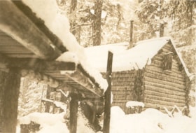
Bridge over the creek in front of "Argu-In" cabin on Mount Seymour
https://search.heritageburnaby.ca/link/museumdescription2921
- Repository
- Burnaby Village Museum
- Date
- [between 1939 and 1949] (date of orignals), copied 2008
- Collection/Fonds
- Pixie McGeachie fonds
- Description Level
- Item
- Physical Description
- 1 photograph (tiff) : b&w ; 600 dpi
- Scope and Content
- Photograph of a snow covered bridge leading to Jack and Pixie McGeachie's log cabin on Mount Seymour, North Vancouver. Jack McGeachie and friends, Maurice Skinner and Jack Gannon built and maintained a cabin with friends on Mount Seymour from 1938 until after the Second World War.
- Repository
- Burnaby Village Museum
- Collection/Fonds
- Pixie McGeachie fonds
- Description Level
- Item
- Physical Description
- 1 photograph (tiff) : b&w ; 600 dpi
- Scope and Content
- Photograph of a snow covered bridge leading to Jack and Pixie McGeachie's log cabin on Mount Seymour, North Vancouver. Jack McGeachie and friends, Maurice Skinner and Jack Gannon built and maintained a cabin with friends on Mount Seymour from 1938 until after the Second World War.
- Subjects
- Natural Phenomena - Snow
- Geographic Features - Forests
- Geographic Features - Mountains - British Columbia
- Buildings - Residential - Cabins
- Accession Code
- BV008.17.10
- Access Restriction
- No restrictions
- Reproduction Restriction
- May be restricted by third party rights
- Date
- [between 1939 and 1949] (date of orignals), copied 2008
- Media Type
- Photograph
- Notes
- Title based on contents of photograph
Images

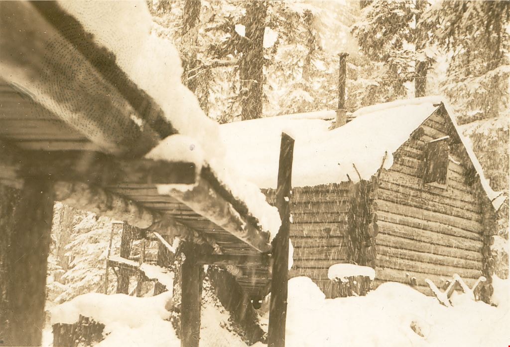
Bridge to "Argu-In" on Mount Seymour
https://search.heritageburnaby.ca/link/museumdescription2926
- Repository
- Burnaby Village Museum
- Date
- [between 1939 and 1949] (date of orignals), copied 2008
- Collection/Fonds
- Pixie McGeachie fonds
- Description Level
- Item
- Physical Description
- 1 photograph (tiff) : b&w ; 600 dpi
- Scope and Content
- Photograph of Jack and Pixie McGeachie's snow covered log cabin, "Argu-In" with a snow covered wooden bridge leading up to it. The photograph is taken from under the bridge which leads to the cabin on Mount Seymour, North Vancouver. Jack McGeachie and friends, Maurice Skinner and Jack Gannon built…
- Repository
- Burnaby Village Museum
- Collection/Fonds
- Pixie McGeachie fonds
- Description Level
- Item
- Physical Description
- 1 photograph (tiff) : b&w ; 600 dpi
- Scope and Content
- Photograph of Jack and Pixie McGeachie's snow covered log cabin, "Argu-In" with a snow covered wooden bridge leading up to it. The photograph is taken from under the bridge which leads to the cabin on Mount Seymour, North Vancouver. Jack McGeachie and friends, Maurice Skinner and Jack Gannon built and maintained a cabin with friends on Mount Seymour from 1938 until after the Second World War.
- Subjects
- Natural Phenomena - Snow
- Geographic Features - Forests
- Geographic Features - Mountains - British Columbia
- Buildings - Residential - Cabins
- Accession Code
- BV008.17.15
- Access Restriction
- No restrictions
- Reproduction Restriction
- May be restricted by third party rights
- Date
- [between 1939 and 1949] (date of orignals), copied 2008
- Media Type
- Photograph
- Notes
- Title based on contents of photograph
Images
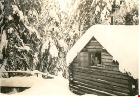
Mount Seymour cabin "Argu-In" in the snow
https://search.heritageburnaby.ca/link/museumdescription2916
- Repository
- Burnaby Village Museum
- Date
- [between 1939 and 1949] (date of orignals), copied 2008
- Collection/Fonds
- Pixie McGeachie fonds
- Description Level
- Item
- Physical Description
- 1 photograph (tiff) : b&w ; 600 dpi
- Scope and Content
- Photograph of log cabin named "Argu-In" covered in snow on Mount Seymour, North Vancouver. Pixie McGeachie is waving out the window of the cabin. Jack McGeachie and friends, Maurice Skinner and Jack Gannon built and maintained a cabin with friends on Mount Seymour, North Vancouver from 1938 unt…
- Repository
- Burnaby Village Museum
- Collection/Fonds
- Pixie McGeachie fonds
- Description Level
- Item
- Physical Description
- 1 photograph (tiff) : b&w ; 600 dpi
- Scope and Content
- Photograph of log cabin named "Argu-In" covered in snow on Mount Seymour, North Vancouver. Pixie McGeachie is waving out the window of the cabin. Jack McGeachie and friends, Maurice Skinner and Jack Gannon built and maintained a cabin with friends on Mount Seymour, North Vancouver from 1938 until after the Second World War.
- Subjects
- Natural Phenomena - Snow
- Geographic Features - Forests
- Geographic Features - Mountains - British Columbia
- Buildings - Residential - Cabins
- Accession Code
- BV008.17.5
- Access Restriction
- No restrictions
- Reproduction Restriction
- May be restricted by third party rights
- Date
- [between 1939 and 1949] (date of orignals), copied 2008
- Media Type
- Photograph
- Notes
- Title based on contents of photograph
Images
