Narrow Results By
Subject
- Animals - Birds 1
- Animals - Dogs 1
- Animals - Horses 1
- Building Components 1
- Buildings - Agricultural 3
- Buildings - Agricultural - Greenhouses 2
- Buildings - Heritage 4
- Buildings - Industrial - Factories 1
- Buildings - Industrial - Mills 1
- Buildings - Industrial - Powerhouses 4
- Buildings - Public - Detention Facilities 1
- Buildings - Residential 1
Person / Organization
- Army, Navy and Air Force Veterans in Canada, Pompier Unit #314 1
- Baker, Ronald J. "Ron" 2
- Barnet Mill 1
- Borstal School 1
- Bossort, Kathy 2
- British Columbia Electric Railway Company 4
- Burnaby Historical Society 2
- Canadian Institute of Mining and Metallurgy 1
- Ceperley, Grace 3
- Ceperley, H.T. 3
- Clayton, Edith Annie Whiting 1
- Damer, Eric 1
B.C. Electric Railway Franchise - Agreement
https://search.heritageburnaby.ca/link/archivedescription382
- Repository
- City of Burnaby Archives
- Date
- 1909-1913
- Collection/Fonds
- City Council and Office of the City Clerk fonds
- Description Level
- File
- Physical Description
- Textual records and architectural drawings
- Scope and Content
- File contains records relating to agreements made between the Corporation of the District of Burnaby and the B.C. Electric Railway Co., for rail line extensions. File also includes a blueprint plan of station structures for Vancouver Fraser Valley and Southern Railway Co. and a newspaper clipping.
- Repository
- City of Burnaby Archives
- Date
- 1909-1913
- Collection/Fonds
- City Council and Office of the City Clerk fonds
- Physical Description
- Textual records and architectural drawings
- Description Level
- File
- Record No.
- 2075
- Accession Number
- 2001-02
- Scope and Content
- File contains records relating to agreements made between the Corporation of the District of Burnaby and the B.C. Electric Railway Co., for rail line extensions. File also includes a blueprint plan of station structures for Vancouver Fraser Valley and Southern Railway Co. and a newspaper clipping.
- Media Type
- Textual Record
- Architectural Drawing
- Notes
- Plans/maps are located in file and have not been moved to map case. File includes original newspaper clipping.
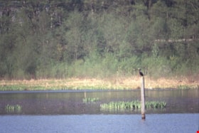
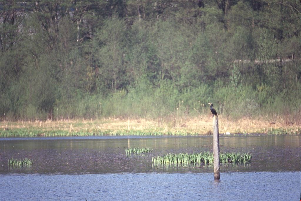
Cormorants
https://search.heritageburnaby.ca/link/archivedescription91686
- Repository
- City of Burnaby Archives
- Date
- 1982-1991
- Collection/Fonds
- Doreen Lawson fonds
- Description Level
- File
- Physical Description
- 4 photographs : col. slides ; 35 mm
- Scope and Content
- File consists of photographs of cormorants. In three of the photographs cormorants are perched on wooded structures on Burnaby Lake; in the forth a cormorant is depicted taking flight from the water. The cormorants are medium-to-large sized birds with dark feathers and long, thin yellow bills.
- Repository
- City of Burnaby Archives
- Date
- 1982-1991
- Collection/Fonds
- Doreen Lawson fonds
- Physical Description
- 4 photographs : col. slides ; 35 mm
- Description Level
- File
- Record No.
- 618-004
- Access Restriction
- No restrictions
- Reproduction Restriction
- No restrictions
- Accession Number
- 2015-15
- Scope and Content
- File consists of photographs of cormorants. In three of the photographs cormorants are perched on wooded structures on Burnaby Lake; in the forth a cormorant is depicted taking flight from the water. The cormorants are medium-to-large sized birds with dark feathers and long, thin yellow bills.
- Media Type
- Photograph
- Photographer
- Lawson, Doreen A.
- Notes
- Transcribed title
- Title transcribed from note on slide sheet photographs were originally housed in
- Historic Neighbourhood
- Burnaby Lake (Historic Neighbourhood)
- Planning Study Area
- Burnaby Lake Area
Images

Mills Burning at Barnet
https://search.heritageburnaby.ca/link/archivedescription38342
- Repository
- City of Burnaby Archives
- Date
- May 6, 1909
- Collection/Fonds
- Burnaby Historical Society fonds
- Description Level
- Item
- Physical Description
- 1 photograph : sepia postcard ; 8 x 13.4 cm
- Scope and Content
- Photographic postcard of the line of buildings burning at the North Pacific Lumber Company, with flames and smoke visible rising from the structures. A caption stamped at the top of the postcard reads: "Mills burning at Barnet BC. 1:30a.m. May 6th, 1909."
- Repository
- City of Burnaby Archives
- Date
- May 6, 1909
- Collection/Fonds
- Burnaby Historical Society fonds
- Subseries
- Charles Lee subseries
- Physical Description
- 1 photograph : sepia postcard ; 8 x 13.4 cm
- Description Level
- Item
- Record No.
- 411-001
- Access Restriction
- No restrictions
- Reproduction Restriction
- No known restrictions
- Accession Number
- BHS2000-13
- Scope and Content
- Photographic postcard of the line of buildings burning at the North Pacific Lumber Company, with flames and smoke visible rising from the structures. A caption stamped at the top of the postcard reads: "Mills burning at Barnet BC. 1:30a.m. May 6th, 1909."
- Names
- Barnet Mill
- Media Type
- Photograph
- Geographic Access
- Barnet Village
- Texaco Drive
- Street Address
- 8059 Texaco Drive
- Historic Neighbourhood
- Barnet (Historic Neighbourhood)
- Planning Study Area
- Burnaby Mountain Area
Images

Tommy Douglas collection
https://search.heritageburnaby.ca/link/archivedescription100683
- Repository
- City of Burnaby Archives
- Date
- 1961-1986
- Collection/Fonds
- Tommy Douglas collection
- Description Level
- Fonds
- Physical Description
- 1.5 cm. of textual records and ephemera.
- Scope and Content
- Fonds consists of materials related to the political career of Tommy Douglas.
- Repository
- City of Burnaby Archives
- Date
- 1961-1986
- Collection/Fonds
- Tommy Douglas collection
- Physical Description
- 1.5 cm. of textual records and ephemera.
- Description Level
- Fonds
- Record No.
- 66688
- Access Restriction
- No restrictions
- Accession Number
- 2022-05
- Scope and Content
- Fonds consists of materials related to the political career of Tommy Douglas.
- History
- Thomas Clement “Tommy” Douglas served as Premier of Saskatchewan from 1944 to 1961, leading the first, and only, Co-operative Commonwealth Federation (CCF) government in Canada. Trained as a Baptist preacher, he became a skilled politician, witty orator, and advocate for social justice, believing political action was the best way to improve Canadians’ lives. As Premier, his government pioneered publicly-funded hospital insurance, which laid the foundations for a national medicare program. He became the first leader of the federal New Democratic Party in 1961, a position he held until 1971, and wielded significant influence defending human rights and strengthening Canada’s social welfare programs. Tommy Douglas was born on October 20, 1904, in Falkirk, Scotland, to a religious, working-class family, who encouraged him to debate politics, religion, and current events while being open to other perspectives. The family moved to Winnipeg, Manitoba, in 1911. His commitment to civil liberties was reinforced after witnessing ‘Bloody Saturday’ during the 1919 Winnipeg General Strike, where several strikers were killed and leaders arrested. He would go on to become an ordained pastor in Weyburn, Saskatchewan, and, in 1933, helped found the CCF, a political coalition of progressive and labour groups with a platform centered on economic reform. Douglas won a federal seat with the CCF in 1935, serving two terms before entering provincial politics. First elected premier of Saskatchewan in 1944, he would serve five terms. His government’s ambitious platform included new administrative structures for economic planning and an innovative program of social reform. It introduced labour and human rights codes and pioneered a new approach to relations between Indigenous Peoples and government. Douglas was also an important influence on the development of medicare in Canada, building on the Saskatchewan tradition of co-operative values to implement the first publicly funded, universally accessible hospital insurance plan in 1947. This was followed by a plan to cover physician services, which concerned doctors worried about regimentation and interference in the doctor-patient relationship. A disruptive 1962 doctor’s strike delayed its implementation, but a compromise was reached and, despite some lingering hostilities, both programs would set the standard for other provinces. This led to federal cost-sharing to facilitate universal, Canada-wide public health care, which remains deeply tied to Canadian identity and values. In 1961, Douglas returned to federal politics as leader of the newly-created New Democratic Party, an alliance between the old CCF and the Canadian Labour Congress. As the third party in Parliament, it was able to use its position to influence minority governments in pushing for the adoption of national social welfare programs, such as medicare and old age pensions. Often the conscience of Parliament on civil liberties, Douglas was one of the few who spoke against the invocation of the War Measures Act during the October Crisis of 1970. Douglas remains a much-admired political figure and the namesake of one of the branches of the Burnaby Public Library. Even those who disagree with his politics admire his pragmatism, oratory skills, integrity, and commitment to social justice. But most of all, Tommy Douglas is an icon for medicare. For his lifetime of service, he was made a Companion of the Order of Canada in 1980. Source: https://www.canada.ca/en/parks-canada/news/2019/03/thomas-clement-tommy-douglas-19041986.html.
- Media Type
- Textual Record
![Vancouver Engineering Works steam donkey, [190-] (date of original), copied 1978 thumbnail](/media/hpo/_Data/_BVM_Images/1977/197800140007.jpg?width=280)
Vancouver Engineering Works steam donkey
https://search.heritageburnaby.ca/link/museumdescription471
- Repository
- Burnaby Village Museum
- Date
- [190-] (date of original), copied 1978
- Collection/Fonds
- Burnaby Village Museum Photograph collection
- Description Level
- Item
- Physical Description
- 1 photograph : b&w ; 20.2 x 25.2 cm print
- Scope and Content
- Photograph of the interior of a large steel foundry. Tucked under the metal brace structures on the left of the photograph are steam donkeys. There is a man lowering a large gear in the centre on a pulley. In the foreground, to the right, is a wheelbarrow. An annotation on the back of the photo …
- Repository
- Burnaby Village Museum
- Collection/Fonds
- Burnaby Village Museum Photograph collection
- Description Level
- Item
- Physical Description
- 1 photograph : b&w ; 20.2 x 25.2 cm print
- Scope and Content
- Photograph of the interior of a large steel foundry. Tucked under the metal brace structures on the left of the photograph are steam donkeys. There is a man lowering a large gear in the centre on a pulley. In the foreground, to the right, is a wheelbarrow. An annotation on the back of the photo reads: "Vancouver Engineering Works - Steam Donkeys."
- Geographic Access
- Vancouver
- Accession Code
- HV978.14.7
- Access Restriction
- No restrictions
- Reproduction Restriction
- No known restrictions
- Date
- [190-] (date of original), copied 1978
- Media Type
- Photograph
- Scan Resolution
- 600
- Scan Date
- 2023-08-01
- Notes
- Title based on contents of photograph
Images
![Vancouver Engineering Works steam donkey, [190-] (date of original), copied 1978 thumbnail](/media/hpo/_Data/_BVM_Images/1977/197800140007.jpg)
Bell's Dry Goods exhibit collection series
https://search.heritageburnaby.ca/link/museumdescription16990
- Repository
- Burnaby Village Museum
- Date
- 1974-2012, predominant 1974-1996
- Collection/Fonds
- Burnaby Village Museum fonds
- Description Level
- Series
- Physical Description
- 129 photographs + 10 cm of textual records + approx. 6 architectural drawings + 1 video recording
- Scope and Content
- Series consists of records pertaining to the moving, restoration, exhibit and repair of the Bell's Dry Goods store and Whitechurch Hardware store building that was relocated from Sixth Avenue to Heritage Village (Burnaby Village Museum) in 1974. The building was set up as a permanent exhibit on sit…
- Repository
- Burnaby Village Museum
- Collection/Fonds
- Burnaby Village Museum fonds
- Description Level
- Series
- Physical Description
- 129 photographs + 10 cm of textual records + approx. 6 architectural drawings + 1 video recording
- Scope and Content
- Series consists of records pertaining to the moving, restoration, exhibit and repair of the Bell's Dry Goods store and Whitechurch Hardware store building that was relocated from Sixth Avenue to Heritage Village (Burnaby Village Museum) in 1974. The building was set up as a permanent exhibit on site at Burnaby Village Museum. The majority of the records were created by museum and City of Burnaby staff. Series is arranged into four subseries: 1) Restoration, upgrades and repairs subseries 2) Bell's building photographs subseries 3) Bell's exhibit photographs subseries 4) Bell's research files subseries
- History
- The Bell's Dry Goods building was built in 1922 by Clifford Tuckey with a small lean to structure on the back housing a kitchen and bedroom. The building was located on the northwest corner of Sixth Street and Thirteenth Avenue in Burnaby. William Bell (1884-1952) and Flora Bell (nee Connell) (1889-1953) immigrated to Burnaby from Scotland between 1917 and 1918. In about 1924, the building was purchased by William and Flora Bell. Flora operated "Bell's Dry Goods" store out of the building and the couple lived at the back of the store. William worked as a driver for a local lumber mill. Bell's Dry Goods was in operation in this one storey building between 1925 and 1937 with the building address, 1314 Sixth Street (later 7695 Sixth Street). In 1927, they moved to a house located on Thirteenth Avenue while they converted the back of the store to include the East Burnaby Post Office. In 1937, the Bells moved the one storey "Bell's Dry Goods" building a little further north and built a two storey building on the corner. Flora continued to operate Bell's Dry Goods on the ground level of the new building until 1941 and the couple lived upstairs. The new two storey building assumed the address of 1314 Sixth Street (later 7695 Sixth Street) and the older one storey building obtained a new address of 1316 Sixth Street (later 7685 Sixth Street). The East Burnaby Post Office continued to operate at 1314 Sixth Street until about 1954. On December 1, 1937, Maurice Whitechurch moved his Whitechurch Hardware store into the one storey building which he rented out from the Bells. In 1943, Maurice Whitechurch purchased the building from the Bells and Whitechurch Hardware store continued to operated at this location until the Spring of 1973. In June 1973, Mr. Fergie Will bought the store and the building was donated to Heritage Village (Burnaby Village Museum). In August 1974, the building was relocated from it's location on Sixth Avenue to Heritage Village. Sometime prior to the move, the extension at the rear of the building was removed. After the building was moved to Heritage Village, some exterior repairs were completed including the installation of exterior siding at the rear of the building and installation of large wood sliding door. The building opened as a carpentry shop exhibit in 1975. In March 1976, an extension at the rear of the building was rebuilt by museum staff. The building underwent several repairs and restorations between 1992 and 1996 and was closed to the public. Due to structural problems, the extension was demolished in 1992. Between 1993 and 1996, the building underwent a series of exterior and interior structural repairs to restore it to Bell's Dry Goods store which included the rebuilding of the extension at the rear of the building and the moving of the building onto a new foundation. The newly restored building opened as Bell's Dry Goods store (exhibit) on August 6, 1996. On November 23, 1992, the building was designated a heritage building under Heritage Designation Bylaw 1992, Bylaw Number 9807.
- Accession Code
- BV019.52
- BV020.5
- Date
- 1974-2012, predominant 1974-1996
- Media Type
- Photograph
- Textual Record
- Architectural Drawing
- Notes
- Title based on contents of series
- Further accruals are expected
- Some records within this collection are subject to FIPPA
- For other records and photographs associated with this building, see also Century Park Museum Association fonds and Burnaby Village Museum fonds and Jesse Love farmhouse fonds
Planning Department fonds
https://search.heritageburnaby.ca/link/archivedescription102
- Repository
- City of Burnaby Archives
- Date
- 1940-2016
- Collection/Fonds
- Planning Department fonds
- Description Level
- Fonds
- Physical Description
- 80 m of textual records and other material
- Scope and Content
- Fonds consists of those records created during the regular conduct of business by the Planning Department and its predecessor agencies according to their mandate of providing professional and technical advice to Council on the current and future uses of City land and resources.
- Repository
- City of Burnaby Archives
- Date
- 1940-2016
- Collection/Fonds
- Planning Department fonds
- Physical Description
- 80 m of textual records and other material
- Description Level
- Fonds
- File Class
- 71000 10 (add. 2020)
- 71000 20 (add. 2020)
- 71000 30 (add. 2020)
- 71000 40 (add. 2020)
- Access Restriction
- Subject to FOIPPA
- Reproduction Restriction
- Reproductions subject to FOIPPA.
- Scope and Content
- Fonds consists of those records created during the regular conduct of business by the Planning Department and its predecessor agencies according to their mandate of providing professional and technical advice to Council on the current and future uses of City land and resources.
- History
- The City of Burnaby Planning Department was established on October 9, 1956, when the City Council unanimously carried the motion to create a distinct department to deal with planning issues within the City and appointed Mr. William John Blakely as its head. This decision followed a report and recommendation made by the City’s Chief Administrative Officer which indicated that the role of the Planning Engineer and his staff had quickly expanded to become a separate division within the Engineering Department and that they were functioning as an independent unit in all but name. The proposed separation of the Engineering and Planning departments had been in the works since the early part of 1956 when staff changes and restructuring within the Engineering Department’s Planning Division illustrated the undermanned condition of the Planning Engineer’s office. As a result, Council asked the Chief Administrative Officer to undertake a study examining the feasibility of creating a distinct Planning Department. This report was delivered to Council on July 3, 1956, but was laid over until a Committee of the Council had the opportunity to study the functions of the Planning department to determine the necessity of the proposal. The Committee’s findings were in line with the initial report and the Planning Department was established with a staff of nine (the head Planning Engineer, an Administrative Planner, three Research Planning Assistants, a Draughtsman, a Subdivision Control Clerk, a department Clerk and a Clerk Stenographer). This new department was to offer advice and carry out the work intensive in matters such as zoning and rezoning applications, subdivision control, traffic and transportation planning, and general City planning schemes. Prior to the creation of the Planning Department, a number of bodies within the City had been responsible for fulfilling the functions carried out by this new unit. In the earliest years of the City, the members of Council were responsible for matters of planning and were assisted in their job by the City’s Engineer or any number of hired consultants (e.g. surveyors, cartographers). By 1906, however, the provincial laws surrounding the subdivision process had changed, and local governments were charged with the task of approving all private subdivision plans in their respective Municipalities. In Burnaby, the City Council passed a bylaw decreeing that all subdivision plans were to be submitted to Council for review and the City Engineer was responsible for ensuring compliance with the law. After the first Town Planning Bylaw in 1924 which restricted the type and size of construction that could occur in certain City areas, the Engineering and Building departments were to work together to oversee the enforcement of the Bylaw and the development of City plans. The scope and competence required to carry out this work grew as Burnaby’s population expanded, and in 1930 Council passed the Town Planning Commission Bylaw (No. 1028) that saw the creation of a permanent body – the Town Planning Commission – which was to serve as an advisory body to help direct the planning activities in the City while the actual work continued to be carried out by the Engineering Department. This body was comprised of the Reeve, the Chairman of the School Board, the Chairman of the Park Committee (later, the Board of Parks Commissioners), and six appointed citizens who served three-year terms. Council referred all matters of subdivisions, transportation planning, and rezoning to this Commission, which was later supported in its work by several other special or standing committees such as the Subdivision Committee, the Apartment Committee, the Transportation Committee or the Town Planning Board of Appeal. By 1953, it had become apparent that the advisory committees that were dedicated to these planning issues needed a permanent staff to carry out the work intensive, so a restructuring of the Engineering department resulted in a permanent Planning Engineer’s office being created. The Town Planning Commission continued in its advisory capacity even after the determination came in 1956 to create a separate Planning Department. When Bylaw No. 4473 was passed in 1963, the Town Planning Commission was disbanded in favour of a new Advisory Planning Commission that would turn over all routine matters such as subdivision and rezoning applications to the Planning Department but would offer advice and community input into the more complex planning schemes within the City and act as an intermediary in cases where Council and Planning staff were in disagreement. A new Advisory Planning Commission Bylaw (No. 7600) was adopted in 1980 which allowed for even greater community participation in the planning process. The Planning Department was initially responsible to report directly to Council, but in 1957, the administrative structure of Municipal staff changed with the introduction of the Burnaby Municipal Manager Bylaw (No. 3859) and from that point on, the head of the Planning Department held a direct reporting relationship to the Municipal Manager, who in turn was responsible for reporting the activities of the Department to the City Council. Over the years, the internal structure and the scope of responsibilities of the Department have changed during periods of staff reorganizations. Under the larger umbrella of the Planning and Building Department, Planning has come to be comprised of two divisions: the Current Planning Division and the Long Range Planning Division. The functions of the Current Planning Division include rezoning, subdivision, development plan areas, preliminary plan approvals, urban design, heritage planning, and urban trails and bicycle routes. The Long Range Planning Division is responsible for environmental planning concerns, transportation planning, housing, neighbourhood area planning, social planning and planning information services. In 2022, the Planning and Building Department was reorganized to better align functions with delivery of services. The Climate Action and Engery Division moved from Corporate Services to the Planning and Building Department, while Indigenous Relations and Facilities Management moved to Corporate Services and Lands and Facilities, respectively. The position of Director of Planning and Building was changed to General Manager, Planning and Development. The following individuals have served as Planning Engineer and/or Director of the Planning Department and/or General Manager, Planning and Development for the City of Burnaby: William John Blakely 1954-1956 (as Planning Engineer) 1956-1963 (as Head of the Department) Anthony P. Parr 1964-1993 Don G. Stenson 1993-2001 Jack S. Belhouse 2001-2006 Basil Luksun 2006-2012 Lou Pelletier 2012-2019 Edward Kozak 2019-present
- Formats
- Microforms exist for some records. See series descriptions.
- Media Type
- Textual Record
- Photograph
- Moving Images
- Creator
- City of Burnaby
- Notes
- Title based on contents of fonds
Ad Hoc Committee on Dog Control subseries
https://search.heritageburnaby.ca/link/archivedescription96029
- Repository
- City of Burnaby Archives
- Date
- 1983-1989
- Collection/Fonds
- City Council and Office of the City Clerk fonds
- Description Level
- Subseries
- Physical Description
- 5 folders of textual records
- Scope and Content
- Subseries consists of committee records for the Ad Hoc Committee on Dog Control including agendas, minutes, correspondence, committee reports, and terms of reference.
- Repository
- City of Burnaby Archives
- Date
- 1983-1989
- Collection/Fonds
- City Council and Office of the City Clerk fonds
- Series
- Council Committee series
- Physical Description
- 5 folders of textual records
- Description Level
- Subseries
- Scope and Content
- Subseries consists of committee records for the Ad Hoc Committee on Dog Control including agendas, minutes, correspondence, committee reports, and terms of reference.
- History
- The Ad Hoc Committee on Dog Control was established by Council on May 25, 1987. Council, at the regular Council meeting held on November 20, 1989 adopted a report to reorganize the committee structure by grouping related subjects and establishing 5 standing committees. The Ad Hoc Committee on Dog Control was dissolved and all matters relating to dog control became the responsibility of the Community Issues and Social Planning Committee.
- Media Type
- Textual Record
Administrative Fee Structure - Upland consents for leases of waterlots in North Arm of the Fraser River opposite Municipally owned properties
https://search.heritageburnaby.ca/link/councilreport19735
- Repository
- City of Burnaby Archives
- Report ID
- 1300
- Meeting Date
- 5-Aug-1980
- Format
- Council - Manager's Report
- Manager's Report No.
- 50
- Item No.
- 24
- Collection/Fonds
- City Council and Office of the City Clerk fonds
- Repository
- City of Burnaby Archives
- Report ID
- 1300
- Meeting Date
- 5-Aug-1980
- Format
- Council - Manager's Report
- Manager's Report No.
- 50
- Item No.
- 24
- Collection/Fonds
- City Council and Office of the City Clerk fonds
Documents
Burnaby Arts Council - Committee Structure
https://search.heritageburnaby.ca/link/archivedescription56388
- Repository
- City of Burnaby Archives
- Date
- 1989
- Collection/Fonds
- Burnaby Historical Society fonds
- Description Level
- File
- Physical Description
- Textual record
- Repository
- City of Burnaby Archives
- Date
- 1989
- Collection/Fonds
- Burnaby Historical Society fonds
- Subseries
- Burnaby Arts Council subseries
- Physical Description
- Textual record
- Description Level
- File
- Record No.
- 39816
- Accession Number
- BHS1998-06
- Media Type
- Textual Record
![Burnaby Substation, [September 1907] thumbnail](/media/hpo/_Data/_Archives_Images/_Unrestricted/251/293-002.jpg?width=280)
Burnaby Substation
https://search.heritageburnaby.ca/link/archivedescription36541
- Repository
- City of Burnaby Archives
- Date
- [September 1907]
- Collection/Fonds
- Burnaby Historical Society fonds
- Description Level
- Item
- Physical Description
- 1 photograph : b&w postcard ; 7.5 x 13 cm
- Scope and Content
- Photographic postcard of the British Columbia Electric Railway Company's Burnaby Substation that was built in 1903 and put into operation to receive and distribute power from the B.C.E.R. Buntzen Lake power dam. The electric lines came across the inlet at Barnet, along the Barnet-Hastings Road to S…
- Repository
- City of Burnaby Archives
- Date
- [September 1907]
- Collection/Fonds
- Burnaby Historical Society fonds
- Subseries
- John DeForest subseries
- Physical Description
- 1 photograph : b&w postcard ; 7.5 x 13 cm
- Description Level
- Item
- Record No.
- 293-002
- Access Restriction
- No restrictions
- Reproduction Restriction
- No known restrictions
- Accession Number
- BHS1992-30
- Scope and Content
- Photographic postcard of the British Columbia Electric Railway Company's Burnaby Substation that was built in 1903 and put into operation to receive and distribute power from the B.C.E.R. Buntzen Lake power dam. The electric lines came across the inlet at Barnet, along the Barnet-Hastings Road to Sperling Avenue (built for this project and called Pole Line Road) and then south to this site at the corner of Griffiths and the old Central Park interurban line (later this section was called the Highland Park line). This substation was constructed to convert the alternating current being delivered from the Buntzen power plant to direct current for the operation of the tram cars operating on the Central Park interurban route. The new brick substation replaced the wood fed steam powered 1891 Powerhouse that operated south of this site, across the tracks until its closure on May 31,1905. It was demolised in the late 1920s. This brick substation originally known as the Burnaby Substation, eventually became known as the Newell Substation. The original brick building was replaced by a new structure in 1930, which was demolished in the 1960s in favour of the open field substation that continues to operate on the same site today at 7260 Griffiths Avenue.
- Subjects
- Buildings - Industrial - Powerhouses
- Media Type
- Photograph
- Notes
- Title based on contents of photograph
- Geographic Access
- Griffiths Avenue
- Historic Neighbourhood
- Edmonds (Historic Neighbourhood)
- Planning Study Area
- Stride Avenue Area
Images
![Burnaby Substation, [September 1907] thumbnail](/media/hpo/_Data/_Archives_Images/_Unrestricted/251/293-002.jpg)
Burnaby Tennis Club's Request to Leave up Air Support Structure from 1984 May 01 to September 30 - Burnaby Lake Sports Centre
https://search.heritageburnaby.ca/link/councilreport17122
- Repository
- City of Burnaby Archives
- Report ID
- 3206
- Meeting Date
- 26-Mar-1984
- Format
- Council - Manager's Report
- Manager's Report No.
- 23
- Item No.
- 16
- Collection/Fonds
- City Council and Office of the City Clerk fonds
- Repository
- City of Burnaby Archives
- Report ID
- 3206
- Meeting Date
- 26-Mar-1984
- Format
- Council - Manager's Report
- Manager's Report No.
- 23
- Item No.
- 16
- Collection/Fonds
- City Council and Office of the City Clerk fonds
Documents
Burnaby Tennis Club's Request to Leave up their Air Support Structure from 1984 May 01 to 1984 June 30
https://search.heritageburnaby.ca/link/councilreport17033
- Repository
- City of Burnaby Archives
- Report ID
- 3290
- Meeting Date
- 7-May-1984
- Format
- Council - Manager's Report
- Manager's Report No.
- 33
- Item No.
- 9
- Collection/Fonds
- City Council and Office of the City Clerk fonds
- Repository
- City of Burnaby Archives
- Report ID
- 3290
- Meeting Date
- 7-May-1984
- Format
- Council - Manager's Report
- Manager's Report No.
- 33
- Item No.
- 9
- Collection/Fonds
- City Council and Office of the City Clerk fonds
Documents
Council Meetings and Committee Structure
https://search.heritageburnaby.ca/link/councilreport12455
- Repository
- City of Burnaby Archives
- Report ID
- 12136
- Meeting Date
- 20-Nov-1989
- Format
- Council - Committee Report
- Collection/Fonds
- City Council and Office of the City Clerk fonds
- Repository
- City of Burnaby Archives
- Report ID
- 12136
- Meeting Date
- 20-Nov-1989
- Format
- Council - Committee Report
- Collection/Fonds
- City Council and Office of the City Clerk fonds
Documents
Demolition of Existing Structure 6285 McKay Avenue Metrotown Civic Facilities Site Rezoning #30/88 Metrotown Area 14
https://search.heritageburnaby.ca/link/councilreport13204
- Repository
- City of Burnaby Archives
- Report ID
- 7878
- Meeting Date
- 6-Feb-1989
- Format
- Council - Manager's Report
- Manager's Report No.
- 11
- Item No.
- 5
- Collection/Fonds
- City Council and Office of the City Clerk fonds
- Repository
- City of Burnaby Archives
- Report ID
- 7878
- Meeting Date
- 6-Feb-1989
- Format
- Council - Manager's Report
- Manager's Report No.
- 11
- Item No.
- 5
- Collection/Fonds
- City Council and Office of the City Clerk fonds
Documents
Finance Advisory Committee subseries
https://search.heritageburnaby.ca/link/archivedescription96451
- Repository
- City of Burnaby Archives
- Date
- 1983-1985
- Collection/Fonds
- City Council and Office of the City Clerk fonds
- Description Level
- Subseries
- Physical Description
- 1 folder of textual records
- Scope and Content
- Subseries consists of committee records for the Finance Advisory Committee.
- Repository
- City of Burnaby Archives
- Date
- 1983-1985
- Collection/Fonds
- City Council and Office of the City Clerk fonds
- Series
- Council Committee series
- Subseries
- Finance Advisory Committee subseries
- Physical Description
- 1 folder of textual records
- Description Level
- Subseries
- Scope and Content
- Subseries consists of committee records for the Finance Advisory Committee.
- History
- The Finance Advisory Committee was established on September 6, 1983. The Committee was introduced in order to provide a counter balance in the decision making process with the Management Committee. Its function was to assist and advise Council on financial matters. On November 20, 1989 Council adopted a report to reorganize the Committee structure, and all matters relating to financial advisory became the responsibility of the Executive Committee of Council.
- Media Type
- Textual Record
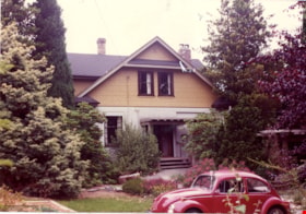
Front of Mawhinney house
https://search.heritageburnaby.ca/link/museumdescription15552
- Repository
- Burnaby Village Museum
- Date
- August 1984
- Collection/Fonds
- Reverend Edward S. Gale fonds
- Description Level
- Item
- Physical Description
- 1 photograph : col. ; 11.5 x 12.5 cm
- Scope and Content
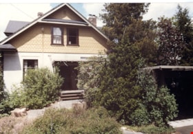
- Photograph of the front of the Mawhinney house located at 7667 Burris Street in Burnaby. The carport structure is visible to the right. Trees and bushes are growing alongside the house and carport.
- Repository
- Burnaby Village Museum
- Collection/Fonds
- Reverend Edward S. Gale fonds
- Description Level
- Item
- Physical Description
- 1 photograph : col. ; 11.5 x 12.5 cm
- Scope and Content
- Photograph of the front of the Mawhinney house located at 7667 Burris Street in Burnaby. The carport structure is visible to the right. Trees and bushes are growing alongside the house and carport.
- Geographic Access
- Burris Street
- Street Address
- 7667 Burris Street
- Accession Code
- BV018.9.20
- Access Restriction
- No restrictions
- Reproduction Restriction
- May be restricted by third party rights
- Date
- August 1984
- Media Type
- Photograph
- Planning Study Area
- Morley-Buckingham Area
- Scan Resolution
- 600
- Scan Date
- April 15, 2021
- Scale
- 100
- Photographer
- Weller, Michael
- Notes
- Title based on contents of photograph
Images
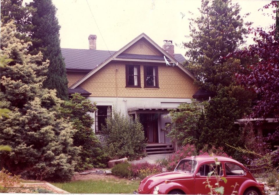
Front of Mawhinney house
https://search.heritageburnaby.ca/link/museumdescription15553
- Repository
- Burnaby Village Museum
- Date
- August 1984
- Collection/Fonds
- Reverend Edward S. Gale fonds
- Description Level
- Item
- Physical Description
- 1 photograph : col. ; 11.5 x 12.5 cm
- Scope and Content
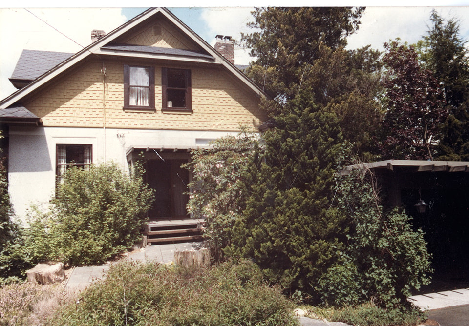
- Photograph of the front of the Mawhinney house located at 7667 Burris Street in Burnaby. The carport structure is visible to the right. Trees and bushes are growing alongside the house and carport. A red Volkswagon beetle car is parked in front.
- Repository
- Burnaby Village Museum
- Collection/Fonds
- Reverend Edward S. Gale fonds
- Description Level
- Item
- Physical Description
- 1 photograph : col. ; 11.5 x 12.5 cm
- Scope and Content
- Photograph of the front of the Mawhinney house located at 7667 Burris Street in Burnaby. The carport structure is visible to the right. Trees and bushes are growing alongside the house and carport. A red Volkswagon beetle car is parked in front.
- Geographic Access
- Burris Street
- Street Address
- 7667 Burris Street
- Accession Code
- BV018.9.21
- Access Restriction
- No restrictions
- Reproduction Restriction
- May be restricted by third party rights
- Date
- August 1984
- Media Type
- Photograph
- Planning Study Area
- Morley-Buckingham Area
- Scan Resolution
- 600
- Scan Date
- April 15, 2021
- Scale
- 100
- Photographer
- Weller, Michael
- Notes
- Title based on contents of photograph
Images
![House with a solarium, [190-?] thumbnail](/media/hpo/_Data/_BVM_Images/1984/1984_0069_0014_001.jpg?width=280)
House with a solarium
https://search.heritageburnaby.ca/link/museumdescription279
- Repository
- Burnaby Village Museum
- Date
- [190-?]
- Collection/Fonds
- Burnaby Village Museum Photograph collection
- Description Level
- Item
- Physical Description
- 1 photograph : b&w ; 5.5 x 9.5 cm mounted on cardboard 10.8 x 15.3 cm
- Scope and Content
- Photograph of an unidentified house. The house is a very large two-storey brick structure with large covered patio on the ground level. There is a man and a woman sitting on a bench on the porch, with a dog sitting in front of the man. There are at least two chimneys visible on the roof, and on the…
- Repository
- Burnaby Village Museum
- Collection/Fonds
- Burnaby Village Museum Photograph collection
- Description Level
- Item
- Physical Description
- 1 photograph : b&w ; 5.5 x 9.5 cm mounted on cardboard 10.8 x 15.3 cm
- Scope and Content
- Photograph of an unidentified house. The house is a very large two-storey brick structure with large covered patio on the ground level. There is a man and a woman sitting on a bench on the porch, with a dog sitting in front of the man. There are at least two chimneys visible on the roof, and on the second floor, there appears to be a solarium with large open windows just above the porch area. The location is not identified.
- Accession Code
- BV984.69.14
- Access Restriction
- No restrictions
- Reproduction Restriction
- No known restrictions
- Date
- [190-?]
- Media Type
- Photograph
- Related Material
- For another photograph of this house, see BV984.69.15
- Scan Resolution
- 600
- Scan Date
- 2023-11-07
- Notes
- Title based on contents of photograph
Images
![House with a solarium, [190-?] thumbnail](/media/hpo/_Data/_BVM_Images/1984/1984_0069_0014_001.jpg)
![Interior of the Burnaby Substation, [September 1908] thumbnail](/media/hpo/_Data/_Archives_Images/_Unrestricted/251/293-003.jpg?width=280)
Interior of the Burnaby Substation
https://search.heritageburnaby.ca/link/archivedescription36542
- Repository
- City of Burnaby Archives
- Date
- [September 1908]
- Collection/Fonds
- Burnaby Historical Society fonds
- Description Level
- Item
- Physical Description
- 1 photograph : b&w postcard ; 7.5 x 13 cm
- Scope and Content
- Photographic postcard of the interior of the British Columbia Electric Railway Company's Burnaby Substation that was built in 1903 and put into operation to receive and distribute power from the B.C.E.R. Buntzen Lake power dam. The electric lines came across the inlet at Barnet, along the Barnet-Ha…
- Repository
- City of Burnaby Archives
- Date
- [September 1908]
- Collection/Fonds
- Burnaby Historical Society fonds
- Subseries
- John DeForest subseries
- Physical Description
- 1 photograph : b&w postcard ; 7.5 x 13 cm
- Description Level
- Item
- Record No.
- 293-003
- Access Restriction
- No restrictions
- Reproduction Restriction
- No known restrictions
- Accession Number
- BHS1992-30
- Scope and Content
- Photographic postcard of the interior of the British Columbia Electric Railway Company's Burnaby Substation that was built in 1903 and put into operation to receive and distribute power from the B.C.E.R. Buntzen Lake power dam. The electric lines came across the inlet at Barnet, along the Barnet-Hastings Road to Sperling Avenue (built for this project and called Pole Line Road) and then south to this site at the corner of Griffiths and the old Central Park interurban line (later this section was called the Highland Park line). This substation was constructed to convert the alternating current being delivered from the Buntzen power plant to direct current for the operation of the tram cars operating on the Central Park interurban route. The new brick substation replaced the wood fed steam powered 1891 Powerhouse that operated south of this site, across the tracks until its closure on May 31,1905. It was demolised in the late 1920s. This brick substation originally known as the Burnaby Substation, eventually became known as the Newell Substation. The original brick building was replaced by a new structure in 1930, which was demolished in the 1960s in favour of the open field substation that continues to operate on the same site today at 7260 Griffiths Avenue.
- Subjects
- Buildings - Industrial - Powerhouses
- Media Type
- Photograph
- Notes
- Title based on contents of photograph
- Geographic Access
- Griffiths Avenue
- Historic Neighbourhood
- Edmonds (Historic Neighbourhood)
- Planning Study Area
- Stride Avenue Area
Images
![Interior of the Burnaby Substation, [September 1908] thumbnail](/media/hpo/_Data/_Archives_Images/_Unrestricted/251/293-003.jpg)