Narrow Results By
Subject
- Academic Disciplines 1
- Accidents 1
- Accidents - Train Accidents 6
- Adminstrative Groups - Committees 4
- Adornment - Jewelry 3
- Advertising Medium 1
- Advertising Medium - Flyer 4
- Advertising Medium - Poster 15
- Advertising Medium - Signs and Signboards 73
- Aerial Photographs
- Agricultural Tools and Equipment 1
- Agriculture 3
Person / Organization
- Bancroft, Rose 1
- Barrington, James Alfred "Jim" 4
- Bingham, Alfred "Alf" 1
- Bossort, Kathy 2
- Brown, Donald N. "Don" 1
- Brown, Monsignor 2
- Burnaby Citizens Association 1
- Burnaby School Disctrict no. 41 1
- Burnaby South High School 1
- Burnaby Village Museum 7
- Century Park Museum Association 1
- Clark, Warren R. 8

Aerial view from Central Park
https://search.heritageburnaby.ca/link/archivedescription78855
- Repository
- City of Burnaby Archives
- Date
- September 27, 1976
- Collection/Fonds
- Burnaby Public Library Contemporary Visual Archive Project
- Description Level
- Item
- Physical Description
- 1 photograph : b&w ; 11 x 16 cm mounted on cardboard
- Scope and Content
- Photograph is an aerial view looking northeast from Central Park with Forest Lawn Memorial Park and Deer Lake in the background.
- Repository
- City of Burnaby Archives
- Date
- September 27, 1976
- Collection/Fonds
- Burnaby Public Library Contemporary Visual Archive Project
- Physical Description
- 1 photograph : b&w ; 11 x 16 cm mounted on cardboard
- Description Level
- Item
- Record No.
- 556-003
- Access Restriction
- No restrictions
- Reproduction Restriction
- Reproduce for fair dealing purposes only
- Accession Number
- 2013-13
- Scope and Content
- Photograph is an aerial view looking northeast from Central Park with Forest Lawn Memorial Park and Deer Lake in the background.
- Subjects
- Aerial Photographs
- Media Type
- Photograph
- Photographer
- Norton, Paul
- Notes
- Scope note taken directly from BPL photograph description.
- 1 b&w copy negative : 10 x 12.5 cm accompanying
- Planning Study Area
- Windsor Area
- Douglas-Gilpin Area
Images


Aerial view looking east on Kingsway
https://search.heritageburnaby.ca/link/archivedescription78857
- Repository
- City of Burnaby Archives
- Date
- September 15, 1976
- Collection/Fonds
- Burnaby Public Library Contemporary Visual Archive Project
- Description Level
- Item
- Physical Description
- 1 photograph : b&w ; 11 x 16 cm mounted on cardboard
- Scope and Content
- Photograph is an aerial view looking east on Kingsway, taken from the twenty-first floor of the Panorama Towers on Grange Street, with Sears and Kelly Douglas in the background.
- Repository
- City of Burnaby Archives
- Date
- September 15, 1976
- Collection/Fonds
- Burnaby Public Library Contemporary Visual Archive Project
- Physical Description
- 1 photograph : b&w ; 11 x 16 cm mounted on cardboard
- Description Level
- Item
- Record No.
- 556-004
- Access Restriction
- No restrictions
- Reproduction Restriction
- Reproduce for fair dealing purposes only
- Accession Number
- 2013-13
- Scope and Content
- Photograph is an aerial view looking east on Kingsway, taken from the twenty-first floor of the Panorama Towers on Grange Street, with Sears and Kelly Douglas in the background.
- Subjects
- Aerial Photographs
- Media Type
- Photograph
- Photographer
- McCarron, John
- Notes
- Scope note taken directly from BPL photograph description.
- 1 b&w copy negative : 10 x 12.5 cm accompanying
- Geographic Access
- Kingsway
- Grange Street
- Historic Neighbourhood
- Central Park (Historic Neighbourhood)
- Planning Study Area
- Maywood Area
- Garden Village Area
Images


Aerial view of Capitol Hill
https://search.heritageburnaby.ca/link/archivedescription78854
- Repository
- City of Burnaby Archives
- Date
- October 14, 1976
- Collection/Fonds
- Burnaby Public Library Contemporary Visual Archive Project
- Description Level
- Item
- Physical Description
- 1 photograph : b&w ; 11 x 16 cm mounted on cardboard
- Scope and Content
- Photograph is an aerial view of Capitol Hill, looking northeast from the Burnaby General Hospital
- Repository
- City of Burnaby Archives
- Date
- October 14, 1976
- Collection/Fonds
- Burnaby Public Library Contemporary Visual Archive Project
- Physical Description
- 1 photograph : b&w ; 11 x 16 cm mounted on cardboard
- Description Level
- Item
- Record No.
- 556-002
- Access Restriction
- No restrictions
- Reproduction Restriction
- Reproduce for fair dealing purposes only
- Accession Number
- 2013-13
- Scope and Content
- Photograph is an aerial view of Capitol Hill, looking northeast from the Burnaby General Hospital
- Subjects
- Aerial Photographs
- Media Type
- Photograph
- Photographer
- Norton, Paul
- Notes
- Scope note taken directly from BPL photograph description.
- 1 b&w copy negative : 10 x 12.5 cm accompanying
- Historic Neighbourhood
- Capitol Hill (Historic Neighbourhood)
Images


Aerial view of Capitol Hill
https://search.heritageburnaby.ca/link/archivedescription78861
- Repository
- City of Burnaby Archives
- Date
- September 27, 1976
- Collection/Fonds
- Burnaby Public Library Contemporary Visual Archive Project
- Description Level
- Item
- Physical Description
- 1 photograph : b&w ; 11 x 16 cm mounted on cardboard
- Scope and Content
- Photograph is an aerial view of Capitol Hill, looking west from Centennial Pavilion on Burnaby Mountain, with the Vancouver skyline in the background.
- Repository
- City of Burnaby Archives
- Date
- September 27, 1976
- Collection/Fonds
- Burnaby Public Library Contemporary Visual Archive Project
- Physical Description
- 1 photograph : b&w ; 11 x 16 cm mounted on cardboard
- Description Level
- Item
- Record No.
- 556-007
- Access Restriction
- No restrictions
- Reproduction Restriction
- Reproduce for fair dealing purposes only
- Accession Number
- 2013-13
- Scope and Content
- Photograph is an aerial view of Capitol Hill, looking west from Centennial Pavilion on Burnaby Mountain, with the Vancouver skyline in the background.
- Subjects
- Aerial Photographs
- Media Type
- Photograph
- Photographer
- Salmon, Stu
- Notes
- Scope note taken directly from BPL photograph description.
- 1 b&w copy negative : 10 x 12.5 cm accompanying
Images


Aerial view of Kingsway and Barker
https://search.heritageburnaby.ca/link/archivedescription78859
- Repository
- City of Burnaby Archives
- Date
- September 27, 1976
- Collection/Fonds
- Burnaby Public Library Contemporary Visual Archive Project
- Description Level
- Item
- Physical Description
- 1 photograph : b&w ; 11 x 16 cm mounted on cardboard
- Scope and Content
- Photograph is an aerial view of Kingsway and Barker Avenue, looking southeast from Central Park Place.
- Repository
- City of Burnaby Archives
- Date
- September 27, 1976
- Collection/Fonds
- Burnaby Public Library Contemporary Visual Archive Project
- Physical Description
- 1 photograph : b&w ; 11 x 16 cm mounted on cardboard
- Description Level
- Item
- Record No.
- 556-005
- Access Restriction
- No restrictions
- Reproduction Restriction
- Reproduce for fair dealing purposes only
- Accession Number
- 2013-13
- Scope and Content
- Photograph is an aerial view of Kingsway and Barker Avenue, looking southeast from Central Park Place.
- Subjects
- Aerial Photographs
- Media Type
- Photograph
- Photographer
- Norton, Paul
- Notes
- Scope note taken directly from BPL photograph description.
- 1 b&w copy negative : 10 x 12.5 cm accompanying
- Geographic Access
- Kingsway
- Barker Avenue
- Historic Neighbourhood
- Central Park (Historic Neighbourhood)
- Planning Study Area
- Maywood Area
- Garden Village Area
Images


Aerial view of Lougheed Highway
https://search.heritageburnaby.ca/link/archivedescription78860
- Repository
- City of Burnaby Archives
- Date
- September 27, 1976
- Collection/Fonds
- Burnaby Public Library Contemporary Visual Archive Project
- Description Level
- Item
- Physical Description
- 1 photograph : b&w ; 11 x 16 cm mounted on cardboard
- Scope and Content
- Photograph is an aerial view of Lougheed Highway, looking northwest from 9304 Salish Court - Tower West.
- Repository
- City of Burnaby Archives
- Date
- September 27, 1976
- Collection/Fonds
- Burnaby Public Library Contemporary Visual Archive Project
- Physical Description
- 1 photograph : b&w ; 11 x 16 cm mounted on cardboard
- Description Level
- Item
- Record No.
- 556-006
- Access Restriction
- No restrictions
- Reproduction Restriction
- Reproduce for fair dealing purposes only
- Accession Number
- 2013-13
- Scope and Content
- Photograph is an aerial view of Lougheed Highway, looking northwest from 9304 Salish Court - Tower West.
- Subjects
- Aerial Photographs
- Media Type
- Photograph
- Photographer
- Campbell, Peg
- Notes
- Scope note taken directly from BPL photograph description.
- 1 b&w copy negative : 10 x 12.5 cm accompanying
- Geographic Access
- Lougheed Highway
- Salish Court
- Historic Neighbourhood
- Burquitlam (Historic Neighbourhood)
- Planning Study Area
- Cameron Area
Images


Aerial view of north Burnaby
https://search.heritageburnaby.ca/link/archivedescription78852
- Repository
- City of Burnaby Archives
- Date
- October 14, 1976
- Collection/Fonds
- Burnaby Public Library Contemporary Visual Archive Project
- Description Level
- Item
- Physical Description
- 1 photograph : b&w ; 11 x 16 cm mounted on cardboard
- Scope and Content
- Photograph is an aerial view of northern Burnaby, looking northeast from the Burnaby General Hospital
- Repository
- City of Burnaby Archives
- Date
- October 14, 1976
- Collection/Fonds
- Burnaby Public Library Contemporary Visual Archive Project
- Physical Description
- 1 photograph : b&w ; 11 x 16 cm mounted on cardboard
- Description Level
- Item
- Record No.
- 556-001
- Access Restriction
- No restrictions
- Reproduction Restriction
- Reproduce for fair dealing purposes only
- Accession Number
- 2013-13
- Scope and Content
- Photograph is an aerial view of northern Burnaby, looking northeast from the Burnaby General Hospital
- Subjects
- Aerial Photographs
- Media Type
- Photograph
- Photographer
- Norton, Paul
- Notes
- Scope note taken directly from BPL photograph description.
- 1 b&w copy negative : 10 x 12.5 cm accompanying
- Historic Neighbourhood
- Broadview (Historic Neighbourhood)
- Planning Study Area
- Cascade-Schou Area
Images


Alfred Bingham's writings - Track 1
https://search.heritageburnaby.ca/link/oralhistory251
- Repository
- City of Burnaby Archives
- Date Range
- 1865-1919
- Length
- 0:10:18
- Summary
- This portion of the recording includes Alfred Bingham's essay entitled Stump Rangers, a listing of early settlers that includes addresses and short descriptions, essays on Confederation Park, land clearing and on Burnaby's first Council meeting.
- Repository
- City of Burnaby Archives
- Summary
- This portion of the recording includes Alfred Bingham's essay entitled Stump Rangers, a listing of early settlers that includes addresses and short descriptions, essays on Confederation Park, land clearing and on Burnaby's first Council meeting.
- Date Range
- 1865-1919
- Photo Info
- Alfred Bingham, April 20, 1947. Item no. 010-066
- Length
- 0:10:18
- Scope and Content
- Recording is of Alfred Bingham's writings, as read by Alfred Bingham. Major themes discussed are: Pioneers, early days in Burnaby and the Co-op Movement. To view "Narrow By" terms for each track expand this description and see "Notes".
- Biographical Notes
- Alfred "Alf" Bingham was born in England in 1892 and moved to Canada in 1912. His first job in Canada was laying track for the Grand Trunk Pacific Railway (GTPR) from Edmonton to McBride in 1912. His second was in Vancouver at the Rat Portage Mill on False Creek, working on the Resaw machine. He quit after one week due to poor working conditions. After taking part in the 1919 Winnipeg General Strike as a delegate of the Retail and Mailorder Union (A.F.L.) on the Winnipeg Trades and Labour Council, Alfred moved to Burnaby where he and fellow Burnaby residents Aungus McLean and Percy Little worked ten hour days to build a Shingle Mill on the edge of Burnaby Lake for Simpson & Giberson. George Green, carpenter and millwright (author of “The History of Burnaby”) also helped in the construction of the mill. Alfred built his own home from lumber cut from the mill in the Lochdale area on Sherlock Street between Curtis Street and Kitchener Street. On April 10, 1920 Alfred married Mary Jane “Ada” Reynolds. Alfred and Ada often took in foster children during their marriage. Due to her nursing experience, Ada was often called upon to deliver babies in the Burnaby area. Alfred and Ada Bingham were instrumental members of the Army of the Common Good, collecting vegetables and grains from growers in the area and even producing over 125 tons of vegetables from its own gardens to feed children and youth suffering from the lack of resources during the Depression years. The army was in operation for ten years and during that time the members organised the Credit Union movement of British Columbia and drew up the Credit Union act thorough the Vancouver Co-operative Council. They also started Co-Op stores and the Co-Op Wholesale Society. Alfred was also Secretary of the Burnaby Housing committee and in 1946 he became the Secretary of the North Burnaby Labour Progressive Party (LPP). Mary Jane “Ada” (Reynolds) Bingham died on August 9, 1969. Her husband Alfred died on April 29, 1979.
- Total Tracks
- 12
- Total Length
- 1:38:06
- Interviewee Name
- Bingham, Alfred "Alf"
- Collection/Fonds
- Burnaby Historical Society fonds
- Subseries
- Oral history subseries
- Transcript Available
- MSS142-001 contains transcripts for each of the short stories
- Media Type
- Sound Recording
- Web Notes
- Interview was digitized in 2010 allowing it to be accessible on Heritage Burnaby. The digitization project was initiated by the Community Heritage Commission with support from City of Burnaby Council and the BC History Digitization Program of the Irving K. Barber Learning Centre, University of British Columbia. It was recognized by the Heritage Society of BC with an award in 2012.
Images

Audio Tracks
Track one of recording of Alfred Bingham's writings
Track one of recording of Alfred Bingham's writings
https://search.heritageburnaby.ca/media/hpo/_Data/_Archives_Oral_Histories/_Unrestricted/100-13-20-2/100-13-20-2_Track_1.mp3
Boundary Road
https://search.heritageburnaby.ca/link/archivedescription79966
- Repository
- City of Burnaby Archives
- Date
- September 27, 1976
- Collection/Fonds
- Burnaby Public Library Contemporary Visual Archive Project
- Description Level
- Item
- Physical Description
- 1 photograph : b&w ; 11 x 16 cm mounted on cardboard
- Scope and Content
- Photograph shows a view of Boundary Road looking south from the railway trestle just north of Kingsway.
- Repository
- City of Burnaby Archives
- Date
- September 27, 1976
- Collection/Fonds
- Burnaby Public Library Contemporary Visual Archive Project
- Physical Description
- 1 photograph : b&w ; 11 x 16 cm mounted on cardboard
- Description Level
- Item
- Record No.
- 556-529
- Access Restriction
- No restrictions
- Reproduction Restriction
- Reproduce for fair dealing purposes only
- Accession Number
- 2013-13
- Scope and Content
- Photograph shows a view of Boundary Road looking south from the railway trestle just north of Kingsway.
- Subjects
- Aerial Photographs
- Media Type
- Photograph
- Photographer
- Norton, Paul
- Notes
- Scope note taken directly from BPL photograph description.
- 1 b&w copy negative : 10 x 12.5 cm accompanying
- Geographic Access
- Boundary Road
- Historic Neighbourhood
- Central Park (Historic Neighbourhood)
- Planning Study Area
- Garden Village Area
Images


Boundary Road
https://search.heritageburnaby.ca/link/archivedescription79967
- Repository
- City of Burnaby Archives
- Date
- September 27, 1976
- Collection/Fonds
- Burnaby Public Library Contemporary Visual Archive Project
- Description Level
- Item
- Physical Description
- 1 photograph : b&w ; 11 x 16 cm mounted on cardboard
- Scope and Content
- Photograph shows a view of Boundary Road looking north from the railway trestle just north of Kingsway.
- Repository
- City of Burnaby Archives
- Date
- September 27, 1976
- Collection/Fonds
- Burnaby Public Library Contemporary Visual Archive Project
- Physical Description
- 1 photograph : b&w ; 11 x 16 cm mounted on cardboard
- Description Level
- Item
- Record No.
- 556-530
- Access Restriction
- No restrictions
- Reproduction Restriction
- Reproduce for fair dealing purposes only
- Accession Number
- 2013-13
- Scope and Content
- Photograph shows a view of Boundary Road looking north from the railway trestle just north of Kingsway.
- Subjects
- Aerial Photographs
- Media Type
- Photograph
- Photographer
- Norton, Paul
- Notes
- Scope note taken directly from BPL photograph description.
- 1 b&w copy negative : 10 x 12.5 cm accompanying
- Geographic Access
- Boundary Road
- Historic Neighbourhood
- Central Park (Historic Neighbourhood)
- Planning Study Area
- Garden Village Area
Images


Boundary Road
https://search.heritageburnaby.ca/link/archivedescription79989
- Repository
- City of Burnaby Archives
- Date
- October, 1976
- Collection/Fonds
- Burnaby Public Library Contemporary Visual Archive Project
- Description Level
- Item
- Physical Description
- 1 photograph : b&w ; 11 x 16 cm mounted on cardboard
- Scope and Content
- Photograph shows view of Boundary Road and the North Shore mountains from 1st Avenue.
- Repository
- City of Burnaby Archives
- Date
- October, 1976
- Collection/Fonds
- Burnaby Public Library Contemporary Visual Archive Project
- Physical Description
- 1 photograph : b&w ; 11 x 16 cm mounted on cardboard
- Description Level
- Item
- Record No.
- 556-545
- Access Restriction
- No restrictions
- Reproduction Restriction
- Reproduce for fair dealing purposes only
- Accession Number
- 2013-13
- Scope and Content
- Photograph shows view of Boundary Road and the North Shore mountains from 1st Avenue.
- Subjects
- Aerial Photographs
- Media Type
- Photograph
- Photographer
- Cook, Alan
- Notes
- Scope note taken directly from BPL photograph description.
- 1 b&w copy negative : 10 x 12.5 cm accompanying
- Geographic Access
- Boundary Road
- Historic Neighbourhood
- Broadview (Historic Neighbourhood)
- Planning Study Area
- West Central Valley Area
Images


Burnaby and Vancouver at Night
https://search.heritageburnaby.ca/link/archivedescription79990
- Repository
- City of Burnaby Archives
- Date
- November, 1976
- Collection/Fonds
- Burnaby Public Library Contemporary Visual Archive Project
- Description Level
- Item
- Physical Description
- 1 photograph : b&w ; 11 x 16 cm mounted on cardboard
- Scope and Content
- Photograph shows view of Burnaby and Vancouver, taken at night, looking west from Burnaby Mountain Pavilion.
- Repository
- City of Burnaby Archives
- Date
- November, 1976
- Collection/Fonds
- Burnaby Public Library Contemporary Visual Archive Project
- Physical Description
- 1 photograph : b&w ; 11 x 16 cm mounted on cardboard
- Description Level
- Item
- Record No.
- 556-546
- Access Restriction
- No restrictions
- Reproduction Restriction
- Reproduce for fair dealing purposes only
- Accession Number
- 2013-13
- Scope and Content
- Photograph shows view of Burnaby and Vancouver, taken at night, looking west from Burnaby Mountain Pavilion.
- Subjects
- Aerial Photographs
- Media Type
- Photograph
- Photographer
- Salmon, Stu
- Notes
- Scope note taken directly from BPL photograph description.
- 1 b&w copy negative : 10 x 12.5 cm accompanying
Images

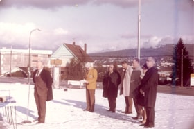
Burnaby Centennial '71 New Year's Day Ceremony
https://search.heritageburnaby.ca/link/museumdescription13644
- Repository
- Burnaby Village Museum
- Date
- 1 Jan 1971
- Collection/Fonds
- Donald Copan collection
- Description Level
- Item
- Physical Description
- 1 photograph : col. ; 8.9 x 12.7 cm
- Scope and Content
- Photograph of Jim Lorimer (M.L.A.) giving a speech as part of the Burnaby Centennial '71 New Year's Day Ceremony taking place on the lawn outside of Burnaby Municipal Hall. Officials standing behind him (L to R): Burnaby Centennial '71 Committee member, Sandy Stewart (dressed in yellow jacket), ch…
- Repository
- Burnaby Village Museum
- Collection/Fonds
- Donald Copan collection
- Series
- Copan album series
- Description Level
- Item
- Physical Description
- 1 photograph : col. ; 8.9 x 12.7 cm
- Scope and Content
- Photograph of Jim Lorimer (M.L.A.) giving a speech as part of the Burnaby Centennial '71 New Year's Day Ceremony taking place on the lawn outside of Burnaby Municipal Hall. Officials standing behind him (L to R): Burnaby Centennial '71 Committee member, Sandy Stewart (dressed in yellow jacket), chair James Barrington, Monsignor Brown and three unidentfied officials. The ground is covered in snow.
- Subjects
- Celebrations - Centennials
- Officials - Aldermen and Councillors
- Officials - Mayors and Reeves
- Geographic Access
- Canada Way
- Street Address
- 4949 Canada Way
- Accession Code
- BV005.54.539
- Access Restriction
- No restrictions
- Reproduction Restriction
- May be restricted by third party rights
- Date
- 1 Jan 1971
- Media Type
- Photograph
- Historic Neighbourhood
- Burnaby Lake (Historic Neighbourhood)
- Planning Study Area
- Douglas-Gilpin Area
- Scan Resolution
- 600
- Scan Date
- August 11, 2020
- Scale
- 100
- Notes
- Title based on contents of photograph
Images

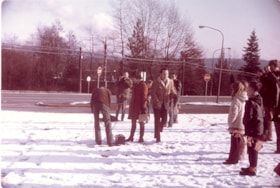
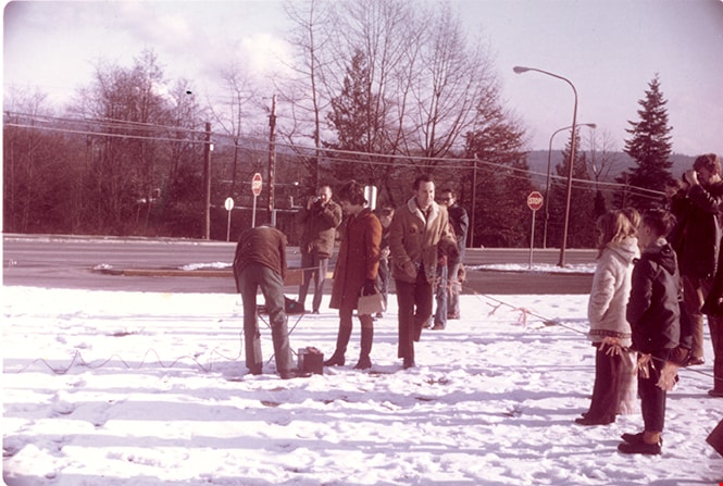
Burnaby Centennial '71 New Year's Day Ceremony
https://search.heritageburnaby.ca/link/museumdescription13646
- Repository
- Burnaby Village Museum
- Date
- 1 Jan 1971
- Collection/Fonds
- Donald Copan collection
- Description Level
- Item
- Physical Description
- 1 photograph : col. ; 8.9 x 12.7 cm
- Scope and Content
- Photograph of people setting up for Burnaby Centennial '71 New Year's Day Ceremony on the lawn outside of Burnaby Municipal Hall. An unidentified man is setting up the microphone and amplifier while Burnaby Centennial '71 Committee member Mary Trainer looks on. Alderman Warren Clark is walking tow…
- Repository
- Burnaby Village Museum
- Collection/Fonds
- Donald Copan collection
- Series
- Copan album series
- Description Level
- Item
- Physical Description
- 1 photograph : col. ; 8.9 x 12.7 cm
- Scope and Content
- Photograph of people setting up for Burnaby Centennial '71 New Year's Day Ceremony on the lawn outside of Burnaby Municipal Hall. An unidentified man is setting up the microphone and amplifier while Burnaby Centennial '71 Committee member Mary Trainer looks on. Alderman Warren Clark is walking towards children standing behind a rope barrier.
- Subjects
- Celebrations - Centennials
- Officials - Aldermen and Councillors
- Officials - Mayors and Reeves
- Geographic Access
- Canada Way
- Street Address
- 4949 Canada Way
- Accession Code
- BV005.54.541
- Access Restriction
- No restrictions
- Reproduction Restriction
- May be restricted by third party rights
- Date
- 1 Jan 1971
- Media Type
- Photograph
- Historic Neighbourhood
- Burnaby Lake (Historic Neighbourhood)
- Planning Study Area
- Douglas-Gilpin Area
- Scan Resolution
- 600
- Scan Date
- August 11, 2020
- Scale
- 100
- Notes
- Title based on contents of photograph
Images

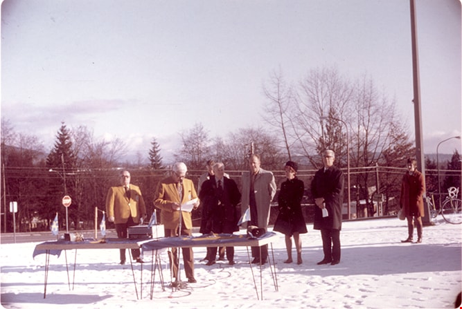
Burnaby Centennial '71 New Year's Day ceremony outside of Burnaby Municipal Hall
https://search.heritageburnaby.ca/link/museumdescription13643
- Repository
- Burnaby Village Museum
- Date
- 1 Jan 1971
- Collection/Fonds
- Donald Copan collection
- Description Level
- Item
- Physical Description
- 1 photograph : col. ; 8.9 x 12.7 cm
- Scope and Content
- Photograph of officials gathered for Burnaby Centennial '71 New Year's Day ceremony outside of Burnaby Municipal Hal. Centennial flags are layed out onto two tables. Burnaby Centennial Committee member and master of ceremonies Sandy Stewart is speaking at the microphone. Officials standing behind h…
- Repository
- Burnaby Village Museum
- Collection/Fonds
- Donald Copan collection
- Series
- Copan album series
- Description Level
- Item
- Physical Description
- 1 photograph : col. ; 8.9 x 12.7 cm
- Scope and Content
- Photograph of officials gathered for Burnaby Centennial '71 New Year's Day ceremony outside of Burnaby Municipal Hal. Centennial flags are layed out onto two tables. Burnaby Centennial Committee member and master of ceremonies Sandy Stewart is speaking at the microphone. Officials standing behind him include; Burnaby Centennial '71 chair James Barrington, Monsignor Brown, Member of Legislative Assembly Mr. Jim Lorimer and Burnaby Centennial '71 Committee co-ordinator Mary Trainer.The ground is covered in snow. identified include;
- Subjects
- Celebrations - Centennials
- Officials - Aldermen and Councillors
- Officials - Mayors and Reeves
- Names
- Barrington, James Alfred "Jim"
- Stewart, A.B. "Sandy"
- Lorimer, James G "Jim"
- Brown, Monsignor
- Trainer, Mary
- Geographic Access
- Canada Way
- Street Address
- 4949 Canada Way
- Accession Code
- BV005.54.538
- Access Restriction
- No restrictions
- Reproduction Restriction
- May be restricted by third party rights
- Date
- 1 Jan 1971
- Media Type
- Photograph
- Historic Neighbourhood
- Burnaby Lake (Historic Neighbourhood)
- Planning Study Area
- Douglas-Gilpin Area
- Scan Resolution
- 600
- Scan Date
- August 11, 2020
- Scale
- 100
- Notes
- Title based on contents of photograph
Images

Burnaby Centre
https://search.heritageburnaby.ca/link/archivedescription79941
- Repository
- City of Burnaby Archives
- Date
- September 27, 1976
- Collection/Fonds
- Burnaby Public Library Contemporary Visual Archive Project
- Description Level
- Item
- Physical Description
- 1 photograph : b&w ; 11 x 16 cm mounted on cardboard
- Scope and Content
- Photograph shows an aerial view of Burnaby Centre looking east from Central Park Place. Kingsway is on the right and Grange Street is on the left.
- Repository
- City of Burnaby Archives
- Date
- September 27, 1976
- Collection/Fonds
- Burnaby Public Library Contemporary Visual Archive Project
- Physical Description
- 1 photograph : b&w ; 11 x 16 cm mounted on cardboard
- Description Level
- Item
- Record No.
- 556-512
- Access Restriction
- No restrictions
- Reproduction Restriction
- Reproduce for fair dealing purposes only
- Accession Number
- 2013-13
- Scope and Content
- Photograph shows an aerial view of Burnaby Centre looking east from Central Park Place. Kingsway is on the right and Grange Street is on the left.
- Media Type
- Photograph
- Photographer
- Norton, Paul
- Notes
- Scope note taken directly from BPL photograph description.
- 1 b&w copy negative : 10 x 12.5 cm accompanying
- Geographic Access
- Kingsway
- Grange Street
- Historic Neighbourhood
- Central Park (Historic Neighbourhood)
- Planning Study Area
- Maywood Area
Images


Burnaby Lake rowing course dredging
https://search.heritageburnaby.ca/link/archivedescription38303
- Repository
- City of Burnaby Archives
- Date
- 1971
- Collection/Fonds
- Burnaby Historical Society fonds
- Description Level
- Item
- Physical Description
- 1 photograph : col. ; 12.5 x 18 cm
- Scope and Content
- Aerial photograph of the Burnaby Lake rowing course being dredged in 1971, in preparation for the 1973 Canada Summer Games.
- Repository
- City of Burnaby Archives
- Date
- 1971
- Collection/Fonds
- Burnaby Historical Society fonds
- Subseries
- Photographs subseries
- Physical Description
- 1 photograph : col. ; 12.5 x 18 cm
- Description Level
- Item
- Record No.
- 400-001
- Access Restriction
- No restrictions
- Reproduction Restriction
- Reproduce for fair dealing purposes only
- Accession Number
- BHS2007-04
- Scope and Content
- Aerial photograph of the Burnaby Lake rowing course being dredged in 1971, in preparation for the 1973 Canada Summer Games.
- Media Type
- Photograph
- Notes
- Title based on contents of photograph
- Geographic Access
- Roberts Street
- Burnaby Lake
- Street Address
- 6871 Roberts Street
- Historic Neighbourhood
- Burnaby Lake (Historic Neighbourhood)
- Planning Study Area
- Burnaby Lake Area
Images


Canada Way
https://search.heritageburnaby.ca/link/archivedescription79957
- Repository
- City of Burnaby Archives
- Date
- September, 1976
- Collection/Fonds
- Burnaby Public Library Contemporary Visual Archive Project
- Description Level
- Item
- Physical Description
- 1 photograph : b&w ; 11 x 16 cm mounted on cardboard
- Scope and Content
- Photograph shows a view looking west along Canada Way, taken from Westminster Avenue.
- Repository
- City of Burnaby Archives
- Date
- September, 1976
- Collection/Fonds
- Burnaby Public Library Contemporary Visual Archive Project
- Physical Description
- 1 photograph : b&w ; 11 x 16 cm mounted on cardboard
- Description Level
- Item
- Record No.
- 556-522
- Access Restriction
- No restrictions
- Reproduction Restriction
- Reproduce for fair dealing purposes only
- Accession Number
- 2013-13
- Scope and Content
- Photograph shows a view looking west along Canada Way, taken from Westminster Avenue.
- Subjects
- Aerial Photographs
- Media Type
- Photograph
- Photographer
- Campbell, Peg
- Notes
- Scope note taken directly from BPL photograph description.
- 1 b&w copy negative : 10 x 12.5 cm accompanying
- Geographic Access
- Canada Way
- Westminster Avenue
- Planning Study Area
- Douglas-Gilpin Area
Images

![Cariboo Cloverleaf, Government Road and Gaglardi Way, [1978] thumbnail](/media/hpo/_Data/_Archives_Images/_Unrestricted/480/480-274.jpg?width=280)
Cariboo Cloverleaf, Government Road and Gaglardi Way
https://search.heritageburnaby.ca/link/archivedescription45379
- Repository
- City of Burnaby Archives
- Date
- [1978]
- Collection/Fonds
- Columbian Newspaper collection
- Description Level
- Item
- Physical Description
- 1 photograph : b&w ; 22.5 x 19 cm
- Scope and Content
- Aerial photograph of the Cariboo Cloverleaf, and the Government Road overpass construction that would join it with Gaglardi Way.
- Repository
- City of Burnaby Archives
- Date
- [1978]
- Collection/Fonds
- Columbian Newspaper collection
- Physical Description
- 1 photograph : b&w ; 22.5 x 19 cm
- Description Level
- Item
- Record No.
- 480-274
- Access Restriction
- No restrictions
- Reproduction Restriction
- No restrictions
- Accession Number
- 2003-02
- Scope and Content
- Aerial photograph of the Cariboo Cloverleaf, and the Government Road overpass construction that would join it with Gaglardi Way.
- Media Type
- Photograph
- Photographer
- King, Basil
- Notes
- Title based on contents of photograph
- Note on recto of photograph reads: "Cariboo cloverleaf in foreground and Government Road overpass construction (centre) will join with Gaglardi Way (top of pic)."
- Geographic Access
- Government Road
- Cariboo Road
- Gaglardi Way
- Historic Neighbourhood
- Burquitlam (Historic Neighbourhood)
- Planning Study Area
- Burnaby Lake Area
- Cariboo-Armstrong Area
- Cameron Area
Images
![Cariboo Cloverleaf, Government Road and Gaglardi Way, [1978] thumbnail](/media/hpo/_Data/_Archives_Images/_Unrestricted/480/480-274.jpg)
![Century Park Museum Association election, [1971] thumbnail](/media/hpo/_Data/_BVM_Images/2005/2005_0054_0445_001.jpg?width=280)
Century Park Museum Association election
https://search.heritageburnaby.ca/link/museumdescription13562
- Repository
- Burnaby Village Museum
- Date
- [1971]
- Collection/Fonds
- Donald Copan collection
- Description Level
- Item
- Physical Description
- 1 photograph : col. ; 8.9 x 8.9 cm
- Scope and Content
- Photograph of people seated on chairs during the meeting of the election for the original board of directors of the Century Park Museum Association. Alderman and Burnaby Centennial '71 Committee member Warren Clark (dressed in jacket and seated behind slide projector) is seated in the front row nex…
- Repository
- Burnaby Village Museum
- Collection/Fonds
- Donald Copan collection
- Series
- Copan album series
- Description Level
- Item
- Physical Description
- 1 photograph : col. ; 8.9 x 8.9 cm
- Scope and Content
- Photograph of people seated on chairs during the meeting of the election for the original board of directors of the Century Park Museum Association. Alderman and Burnaby Centennial '71 Committee member Warren Clark (dressed in jacket and seated behind slide projector) is seated in the front row next to Burnaby Parks Commissioner and Burnaby Centennial '71 Committee member A.B. "Sandy" Stewart.
- Subjects
- Elections
- Organizations - Societies and Clubs
- Officials - Aldermen and Councillors
- Officials - Commissioners
- Accession Code
- BV005.54.445
- Access Restriction
- No restrictions
- Reproduction Restriction
- May be restricted by third party rights
- Date
- [1971]
- Media Type
- Photograph
- Scan Resolution
- 600
- Scan Date
- August 11, 2020
- Scale
- 100
- Notes
- Title based on contents of photograph
Images
![Century Park Museum Association election, [1971] thumbnail](/media/hpo/_Data/_BVM_Images/2005/2005_0054_0445_001.jpg)