Narrow Results By
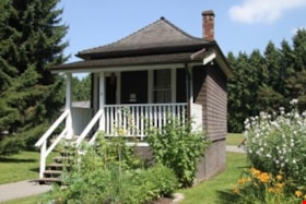
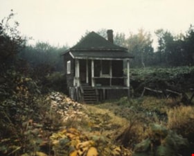
Thomas Irvine House
https://search.heritageburnaby.ca/link/landmark536
- Repository
- Burnaby Heritage Planning
- Description
- The Thomas Irvine House is a very small, two room wood frame cottage, originally located on Laurel Street in Central Burnaby (now the site of the Burnaby Lake Sports Complex - West), and now relocated to the Burnaby Village Museum.
- Associated Dates
- 1911
- Formal Recognition
- Heritage Designation, Community Heritage Register
- Other Names
- Tommy Irvine House
- Repository
- Burnaby Heritage Planning
- Other Names
- Tommy Irvine House
- Geographic Access
- Deer Lake Avenue
- Associated Dates
- 1911
- Formal Recognition
- Heritage Designation, Community Heritage Register
- Enactment Type
- Bylaw No. 9807
- Enactment Date
- 23/11/1992
- Description
- The Thomas Irvine House is a very small, two room wood frame cottage, originally located on Laurel Street in Central Burnaby (now the site of the Burnaby Lake Sports Complex - West), and now relocated to the Burnaby Village Museum.
- Heritage Value
- The Thomas Irvine House is representative of an extremely modest, vernacular working-class cottage of the early twentieth century, once common but mostly now demolished. Irish-born Thomas Irvine (1864-1964) and his friend, Robert Moore, constructed the house in 1911 to suit the simple needs of a bachelor. Irvine worked on the construction of the British Columbia Electric Railway Burnaby Lake Interurban Line and was a pile driver by trade. The house consists of two rooms, a living room/kitchen and a bedroom. There were some improvements made throughout the fifty years Irvine lived there, such as running water in 1929, and electricity in the 1950s, but the essential character and form of the house remained intact. Irvine was a well-known local character and pioneer of Burnaby. The heritage value for this house also lies in its interpretive value within the Burnaby Village Museum. The site is an important cultural feature for the interpretation of Burnaby’s heritage to the public. The Thomas Irvine House was moved to the Burnaby Village Museum in 1975 and was restored to its 1920s appearance.
- Defining Elements
- The character defining elements of the Thomas Irvine House include its: - rectangular form and simple massing - bellcast hipped form with cedar shingle cladding - cedar shingle cladding stained dark brown - double-hung 1-over-1 wooden-sash window on front facade; simple double wooden-sash casement on west facade - interior layout of the house with 2 rooms, a living room/kitchen and bedroom - V-joint tongue-and-groove wood interior paneling
- Locality
- Deer Lake Park
- Historic Neighbourhood
- Burnaby Lake (Historic Neighbourhood)
- Planning Study Area
- Morley-Buckingham Area
- Organization
- British Columbia Electric Railway
- Burnaby Village Museum
- Builder
- Thomas Irvine (Owner)
- Robert Moore
- Function
- Primary Current--Museum
- Primary Historic--Single Dwelling
- Community
- Burnaby
- Cadastral Identifier
- P.I.D. No. 011-030-356 Legal Description: Parcel 1, District Lot 79 and District Lot 85, Group 1, New Westminster District, Reference Plan 77594
- Boundaries
- Burnaby Village Museum is comprised of a single municipally-owned property located at 6501 Deer Lake Avenue, Burnaby.
- Area
- 38,488.63
- Contributing Resource
- Building
- Landscape Feature
- Structure
- Ownership
- Public (local)
- Documentation
- Heritage Site Files: PC77000 20. City of Burnaby Planning and Building Department, 4949 Canada Way, Burnaby, B.C., V5G 1M2
- Names
- Irvine, Tom
- Street Address
- 6501 Deer Lake Avenue
Images
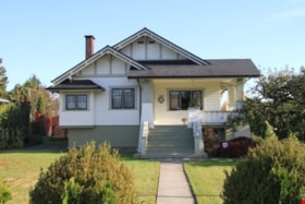
George S. Vickers Residence
https://search.heritageburnaby.ca/link/landmark586
- Repository
- Burnaby Heritage Planning
- Description
- Residential building.
- Associated Dates
- 1911
- Street View URL
- Google Maps Street View
- Repository
- Burnaby Heritage Planning
- Geographic Access
- 1st Street
- Associated Dates
- 1911
- Description
- Residential building.
- Heritage Value
- George S. Vickers, a compositor with The British Columbian newspaper, was a prominent Burnaby resident who became involved with real estate during the boom prior to the First World War. In December 1910, The British Columbian reported that “Mr. Vickers has commenced to build a commodious residence on Fourth Avenue between 1st and 2nd streets.” This high quality Craftsman style bungalow, completed in 1911, was originally situated on one acre of property, which contained a large kitchen garden, an orchard of 40 trees of various types and houses and runs for chickens, ducks and turkeys. In 1919, the property was advertised for $5,000 and likely sold easily because of its location (three blocks from the electric streetcar line on Sixth Street), its many amenities and property improvements. Some of its selling points included its panelled living and dining room with 3-ply veneer, beamed ceilings and an open fireplace. Craftsman-style features include battered porch piers, unusual double bargeboards, triangular eave brackets and exposed purlins. The house survives in excellent original condition, with only minor alterations.
- Locality
- East Burnaby
- Historic Neighbourhood
- East Burnaby (Historic Neighbourhood)
- Planning Study Area
- Cariboo-Armstrong Area
- Area
- 819.46
- Contributing Resource
- Building
- Ownership
- Private
- Street Address
- 7686 1st Street
- Street View URL
- Google Maps Street View
Images
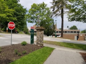
H.T. Ceperley Estate 'Fairacres' Estate Gate
https://search.heritageburnaby.ca/link/landmark863
- Repository
- Burnaby Heritage Planning
- Description
- The 'Fairacres Estate Gate' marks the location of one of the original driveway entrances to the estate.
- Associated Dates
- 1911
- Formal Recognition
- Heritage Designation, Community Heritage Register
- Street View URL
- Google Maps Street View
- Repository
- Burnaby Heritage Planning
- Geographic Access
- Deer Lake Avenue
- Associated Dates
- 1911
- Formal Recognition
- Heritage Designation, Community Heritage Register
- Enactment Type
- Bylaw No. 140665
- Enactment Date
- 23/11/1992
- Description
- The 'Fairacres Estate Gate' marks the location of one of the original driveway entrances to the estate.
- Heritage Value
- Fairacres was designed as a country estate with a working farm that included over 10 acres of productive berry and vegetable fields, with a large kitchen garden, a root house to store food, and greenhouses heated by steam. The agricultural potential ofthe Deer Lake area made it one of the first parts of the municipality to attract settlement. Construction of the Fairacres Estate represented a shift toward wealthy country estates over more modest farms, and the Ceperleys employed a large staff to manage the estate's agricultural production. Agricultural use of the estate continued when a Catholic order of Benedictine monks purchased the estate as part of the Priory of St. Joseph and the Seminary of Christ the King, and continued to farm the land until 1953. The overall architectural intention of the estate's architect was to reflect the ideals of the Arts & Crafts movement to showcase craftsmanship, and to incorporate high quality materials, including many local materials, such as wood and stone from the site. On the mansion exterior, the rustic style is seen in the use of natural materials such as cedar shingles and siding, cobblestone foundations and chimneys and the half-timbering in gable ends. The estate's remaining gate pillar features the same rustic field and cobblestones used on the mansion. The original estate driveway had two entrances constructed in 1910, each marked by a pair of entry gate pillars which supported iron gates. The main entrance gate pillars which marked the lower driveway and the east pillar of the upper entrance were demolished many years ago and the iron gates removed. A single gate pillar remains marking the upper driveway, adjacent to the Garage and Stables. This gate pillar is a significant site feature and incorporates cobble stone and a carved sandstone capstone.
- Defining Elements
- Key elements that define the heritage character of the ‘Fairacres Estate Gate' include: - setting in relation to the estate boundary and estate buildings - Cobble stone and sandstone construction, which represents a typical Arts and Crafts use of local materials, and matches the extensive use of cobblestone as chimneys and foundations on the Fairacres mansion, as well as the use of sandstone on the mansion's exterior.
- Locality
- Deer Lake Park
- Historic Neighbourhood
- Burnaby Lake (Historic Neighbourhood)
- Planning Study Area
- Douglas-Gilpin Area
- Function
- Primary Historic--Estate
- Community
- Burnaby
- Cadastral Identifier
- P.I.D. No. 004-493-311 Legal Description: Block 3 Except: Part subdivided by Plan 26865, District Lot 79, Group 1, New Westminster District, Plan 536
- Boundaries
- ‘Fairacres’ is comprised of a single municipally-owned property located at 6344 Deer Lake Avenue, Burnaby.
- Area
- 17,065.00
- Contributing Resource
- Landscape Feature
- Ownership
- Public (local)
- Other Collection
- Burnaby Historical Society, Community Archives: Ceperley Photograph Album
- Documentation
- Heritage Site Files: PC77000 20. City of Burnaby Planning and Building Department, 4949 Canada Way, Burnaby, B.C., V5G 1M2
- Subjects
- Structures - Fences
- Street Address
- 6344 Deer Lake Avenue
- Street View URL
- Google Maps Street View
Images
Love family fonds
https://search.heritageburnaby.ca/link/museumdescription10098
- Repository
- Burnaby Village Museum
- Date
- 1881-1971
- Collection/Fonds
- Love family fonds
- Description Level
- Fonds
- Physical Description
- 11 cm of textual records + 44 photographs + 5 plans
- Scope and Content
- Fonds consists of family records including photographs, land sale records, agreements and plans as well as estate records, vital event documentation and correspondence. Records pertain to members of the Love family including the Parkers, Hughes and Leonards. Fonds has been arranged in the followin…
- Repository
- Burnaby Village Museum
- Collection/Fonds
- Love family fonds
- Description Level
- Fonds
- Physical Description
- 11 cm of textual records + 44 photographs + 5 plans
- Scope and Content
- Fonds consists of family records including photographs, land sale records, agreements and plans as well as estate records, vital event documentation and correspondence. Records pertain to members of the Love family including the Parkers, Hughes and Leonards. Fonds has been arranged in the following series: 1) Love and Leonard land records 2) Love family vital events and correspondence 3) Love family photographs
- History
- Jesse Love was born in Swindon, England in 1847 and left England to work on a dairy farm in the Toronto area. While working on the farm in Toronto, he met Martha Leonard who he married in 1879. Martha was born on February 3, 1858 in Bedfordshire, England and had come to Canada with her parents George and Ann Leonard. While living in Toronto, Jesse and Martha had two children, George born March 22, 1880 and Annie Elizabeth on August 24, 1881. About one year after Annie was born, the Love family moved to North Dakota to grow wheat. While living there, they had two more children, Henry who was born August 24, 1883 and Edith Minnie born October 9, 1885. The family decided to move further west after hearing about the fairer weather conditions from Martha’s father, George Leonard, who had settled in Vancouver in 1885. On May 23, 1887, Jesse, Martha and their four children arrived in Vancouver after travelling across Canada from Winnipeg on the first transcontinental train. The Loves made their home in Vancouver while Jesse helped clear land on Granville Street. Their fifth child, Thomas Robert was born on September 17, 1887 and soon after, the family moved to Lulu Island in Richmond where they lived growing vegetables and selling them to Vancouver hotels. While living and farming on Lulu island, the couple had two more girls, Martha (Dot or Dorothy) born on December 17, 1889 and Sarah Marie, born February 8, 1892. On October 6, 1893 an agreement was signed by Jesse Love to purchase 14.52 acres of land from Joseph C. Armstrong. The acreage covered the north east section of District Lot 25 within the newly incorporated District of the Municipality of Burnaby. It was here where the original Love house was built (between October 1893 and April 15, 1894) by Jesse Love with the help of local builder George Salt and father in law, George Leonard. The house consisted of an entrance hall, dining room, lean to kitchen, master bedroom and three bedrooms upstairs. A road was constructed and named Cumberland in 1905 and ran from District Lot 25 through to District Lot 11. The address for the Love home was 1390 Cumberland Road and in the early 1960’s the address was renumbered 7651 Cumberland Street. On the land surrounding the house, Jesse Love planted an orchard along with strawberries and raspberries which he sold at the Fraser Valley Market, T.S. Anandale’s Grocery Store in New Westminster and to hotels around Vancouver. Jesse Love served on the Burnaby School Board and also as a District Councillor in 1901 and from 1904-1907. While living in the house, Jesse and Martha had four more children, Phoebe Leonard, born April 15, 1894, Esther, born August 28, 1896, John Leonard, born June 7, 1899 and Hannah Victoria (also known as Girlie) who was born May 12, 1902. In 1918, at the age of 31 years, Thomas Robert Love fell ill due to an influenza epidemic and died on November 23, 1918. Following their son’s death, Martha Love became weak and on August 24, 1920, she passed away. By this time, Jesse had sold off a large percentage of his land and his youngest daughter, Girlie decided to stay on to live and care for him. Since the house was too large for just the two of them, Jesse invited any other children to return and share the residence. For a while his son, George and his wife joined them. In 1925 Jesse’s daughter Sarah Parker (nee Love), her husband William Michael Norton Parker and their three children, Albert “Bert” (1915-2011), William Charles “Bill” and Elsie Roberta moved from their home at 1319 Newcombe Street to join Jesse and Girlie in the Love family home on Cumberland. Jesse Love died in 1928 after which Sarah and William Parker purchased the Love family farmhouse and property. William Michael Parker, died in 1961 and Sarah Parker continued to live in the Love family farmhouse until 1966 when she sold it to her daughter Elsie and husband John Hughes. Elsie and John Hughes had four children, John Jr., Ann, Brent and Merle. The Hughes lived in the Love family house until August 1971. In 1988 the Love family farmhouse house was donated to the Burnaby Village Museum and moved to the site of Burnaby Village Museum. The interior of the main floor and exterior of the house went through an extensive restoration process. In 1997, restoration of the kitchen was completed and opened to the public. After the completion of the hallway, dining room, main floor bedroom and parlour, the Love farmhouse exhibit opened on November 29, 1998 with an open invitation to the public and extended members of the Love family.
- Responsibility
- Love Family
- Accession Code
- HV979.40
- BV985.3136
- BV988.45
- BV989.3
- BV992.15
- BV992.26
- BV992.34
- BV000.45
- BV008.20
- BV012.31
- BV019.3
- BV019.8
- Date
- 1881-1971
- Media Type
- Textual Record
- Photograph
- Cartographic Material
- Arrangement
- Fonds has been arranged by record type and original order provided by members of the Love family.
- Notes
- Title based on contents of fonds
- See also Burnaby Village Museum fonds - Jesse Love farmhouse series


