More like 'Alfred Bingham's writings - Track 2'
Narrow Results By
Subject
- Buildings - Commercial - Grocery Stores 1
- Buildings - Commercial - Service Stations 1
- Buildings - Heritage 1
- Buildings - Schools 4
- Education 1
- Geographic Features - Roads 1
- Land Clearing 3
- Migration 1
- Occupations - Grocers 1
- Occupations - Teachers 1
- Organizations 1
- Organizations - Business Associations 1

Douglas Road School
https://search.heritageburnaby.ca/link/landmark573
- Repository
- Burnaby Heritage Planning
- Description
- School building.
- Associated Dates
- 1928
- Other Names
- Douglas Road Elementary School
- Street View URL
- Google Maps Street View
- Repository
- Burnaby Heritage Planning
- Other Names
- Douglas Road Elementary School
- Geographic Access
- Canada Way
- Associated Dates
- 1928
- Description
- School building.
- Heritage Value
- The Douglas Road School was originally established as a two-room school in 1908 on this site, and later expanded to four classrooms. Anticipating rapid settlement of this district, the School Board purchased two acres adjoining the old building. Two of the four rooms were designed to become one large auditorium suitable for special events and public gatherings, with seating for two hundred people. The classically-influenced school has been altered with new windows and extended with additional wings, but has retained its original red-brick veneer, tan-brick quoins and bellcast octagonal roof ventilator. Designed by McCarter & Nairne, the school was built by contractor A.S. Perry. McCarter & Nairne, who also designed the Second Street School, were the Burnaby School Board architects at this time. John Y. McCarter (1886-1981) and George Nairne (1884-1953) formed their partnership in 1921 after serving overseas during the First World War. The partners began designing houses and small apartment buildings, and their commissions included Vancouver’s first skyscraper, the Marine Building (1928-30).
- Locality
- Burnaby Lake
- Historic Neighbourhood
- Burnaby Lake (Historic Neighbourhood)
- Planning Study Area
- Douglas-Gilpin Area
- Architect
- McCarter & Nairne
- Subjects
- Buildings - Heritage
- Buildings - Schools
- Street Address
- 4861 Canada Way
- Street View URL
- Google Maps Street View
Images


![Douglas Road, [1897] (date of original), copied 1978 thumbnail](/media/hpo/_Data/_BVM_Images/1978/1978_0001_0001_001.jpg?width=280)
Douglas Road
https://search.heritageburnaby.ca/link/museumdescription447
- Repository
- Burnaby Village Museum
- Date
- [1897] (date of original), copied 1978
- Collection/Fonds
- Burnaby Village Museum Photograph collection
- Description Level
- Item
- Physical Description
- 1 photograph : b&w ; 20.2 x 25.2 cm print
- Scope and Content
- Photograph of Douglas Road (later renamed in part Canada Way), near Stanley Street. To the right is the Sprott family property, where a few wooden buildings are visible in the cleared area. Charles Sprott, head of the Sprott family, was an important Burnaby politician who was continuously elected t…
- Repository
- Burnaby Village Museum
- Collection/Fonds
- Burnaby Village Museum Photograph collection
- Description Level
- Item
- Physical Description
- 1 photograph : b&w ; 20.2 x 25.2 cm print
- Scope and Content
- Photograph of Douglas Road (later renamed in part Canada Way), near Stanley Street. To the right is the Sprott family property, where a few wooden buildings are visible in the cleared area. Charles Sprott, head of the Sprott family, was an important Burnaby politician who was continuously elected to serve in the municiality as councillor from 1895 to 1903 and as Reeve from 1904 to 1905.
- Subjects
- Geographic Features - Roads
- Land Clearing
- Geographic Access
- Douglas Road
- Canada Way
- Stanley Street
- Accession Code
- HV978.1.1
- Access Restriction
- No restrictions
- Reproduction Restriction
- No known restrictions
- Date
- [1897] (date of original), copied 1978
- Media Type
- Photograph
- Historic Neighbourhood
- Burnaby Lake (Historic Neighbourhood)
- Planning Study Area
- Lakeview-Mayfield Area
- Scan Resolution
- 600
- Scan Date
- 2023-07-25
- Notes
- Title based on contents of photograph
Images
![Douglas Road, [1897] (date of original), copied 1978 thumbnail](/media/hpo/_Data/_BVM_Images/1978/1978_0001_0001_001.jpg)
![Claude Hill, the son of Bernard and Marian Hill, [1888]. Item no. 477-933 thumbnail](/media/hpo/_Data/_Archives_Images/_Unrestricted/477/477-933.jpg?width=280)
Interview with Claude Hill and Marion Hill November 7, 1977 - Track 4
https://search.heritageburnaby.ca/link/oralhistory250
- Repository
- City of Burnaby Archives
- Date Range
- 1892-1905
- Length
- 0:04:58
- Summary
- This portion of the interview pertains to A. Claude Hill's memories of how his father cleared land to build a house, including the equipment that was used.
- Repository
- City of Burnaby Archives
- Summary
- This portion of the interview pertains to A. Claude Hill's memories of how his father cleared land to build a house, including the equipment that was used.
- Date Range
- 1892-1905
- Photo Info
- Claude Hill, the son of Bernard and Marian Hill, [1888]. Item no. 477-933
- Length
- 0:04:58
- Names
- Hill, Bernard R
- Subjects
- Land Clearing
- Geographic Access
- Douglas Road
- Canada Way
- Historic Neighbourhood
- Burnaby Lake (Historic Neighbourhood)
- Planning Study Area
- Douglas-Gilpin Area
- Interviewer
- Stevens, Colin
- Interview Date
- November 7, 1977
- Scope and Content
- Recording is of an interview with A. Claude Hill and his wife Marion Hill, conducted by Colin Stevens, November 7, 1977. Major themes discussed are: Christmas traditions and his Deer Lake neighbourhood.
- Biographical Notes
- Claude Hill was born in England about 1885, the eldest son of Marian (Berkeley) and Bernard R. Hill. His younger sibling were Frank, Winnie and Minard Gerald “Gerry.” Claude Hill was named after Bernard’s older brother, Louis Claude Hill. Claude's father, Bernard R. Hill was born in Bengal, India while his father worked for the East Indian Railway. He and his older brother Uncle Claude became strawberry farmers in Burnaby despite their years of training as engineers. Between them, the Hill brothers owned all the land between Burnaby Lake and Deer Lake where Deer Creek runs, and half way around Deer Lake. After the decline in the strawberry industry, Bernard worked as a surveyor for the municipality. He also served as Burnaby Councillor and School Trustee. Bernard built his family home at Douglas Road near Deer Lake in 1892. His oldest child, Claude was seven years old at the time and his first years of school in Burnaby were at Douglas Road. Later, Claude rode a horse and buggy with his younger brother to travel to school in New Westminster. A.Claude Hill married Marion "Mamie" in his early twenties.
- Total Tracks
- 4
- Total Length
- 0:30:00
- Interviewee Name
- Hill, Claude
- Hill, Marion
- Collection/Fonds
- Burnaby Historical Society fonds
- Subseries
- Oral history subseries
- Media Type
- Sound Recording
- Web Notes
- Interview was digitized in 2010 allowing it to be accessible on Heritage Burnaby. The digitization project was initiated by the Community Heritage Commission with support from City of Burnaby Council and the BC History Digitization Program of the Irving K. Barber Learning Centre, University of British Columbia. It was recognized by the Heritage Society of BC with an award in 2012.
Images
![Claude Hill, the son of Bernard and Marian Hill, [1888]. Item no. 477-933 thumbnail](/media/hpo/_Data/_Archives_Images/_Unrestricted/477/477-933.jpg)
Audio Tracks
Track four of interview with Claude Hill and Marion Hill
Track four of interview with Claude Hill and Marion Hill
https://search.heritageburnaby.ca/media/hpo/_Data/_Archives_Oral_Histories/_Unrestricted/MSS137-019-1/MSS137-019-1_Track_4.mp3
Land being cleared for Saint Theresa's Roman Catholic Church
https://search.heritageburnaby.ca/link/museumdescription902
- Repository
- Burnaby Village Museum
- Date
- 1929
- Collection/Fonds
- Burnaby Village Museum Photograph collection
- Description Level
- Item
- Physical Description
- 1 photograph : b&w ; 6.7 x 11.4 cm
- Scope and Content
- Photograph of three unidentified men standing on Douglas Road (later renamed in part Canada Way) with Laurel Street in the background on the left and the site of Saint Theresa's Roman Catholic Church as a lot with blackened stumps. The church was located at the southeast corner of Canada Way and L…
- Repository
- Burnaby Village Museum
- Collection/Fonds
- Burnaby Village Museum Photograph collection
- Description Level
- Item
- Physical Description
- 1 photograph : b&w ; 6.7 x 11.4 cm
- Scope and Content
- Photograph of three unidentified men standing on Douglas Road (later renamed in part Canada Way) with Laurel Street in the background on the left and the site of Saint Theresa's Roman Catholic Church as a lot with blackened stumps. The church was located at the southeast corner of Canada Way and Laurel Street. According to an accompanying note located with the photograph, the first church building burned to the ground the night before it was to be blessed. Insurance for the church had been arranged for by Colonel Dorrell only hours before it was burned and even though signatures had not been affixed to the policy, the insurance company honoured the claim. The second building was smaller and had no basement. Father Trainer was the first priest. This church was torn down in 1974 and a new church building was erected across the road on Canada Way.
- Subjects
- Land Clearing
- Geographic Access
- Douglas Road
- Canada Way
- Laurel Street
- Accession Code
- HV975.105.1
- Access Restriction
- No restrictions
- Reproduction Restriction
- No known restrictions
- Date
- 1929
- Media Type
- Photograph
- Historic Neighbourhood
- Burnaby Lake (Historic Neighbourhood)
- Planning Study Area
- Douglas-Gilpin Area
- Scan Resolution
- 600
- Scan Date
- 2023-06-06
- Notes
- Title based on contents of photograph
- Information on the scope and content of the photograph is taken from an acquisition record from the time of the accession
Images

Edmonds School building
https://search.heritageburnaby.ca/link/archivedescription34292
- Repository
- City of Burnaby Archives
- Date
- 1920
- Collection/Fonds
- Burnaby Historical Society fonds
- Description Level
- Item
- Physical Description
- 1 photograph : b&w ; 8.6 x 14.6 cm
- Scope and Content
- Photograph of the exterior of Burnaby's first school building, located on Douglas Road near Edmonds Street. It was originally named Burnaby School, then East Burnaby School, and later Edmonds Street School.
- Repository
- City of Burnaby Archives
- Date
- 1920
- Collection/Fonds
- Burnaby Historical Society fonds
- Subseries
- Photographs subseries
- Physical Description
- 1 photograph : b&w ; 8.6 x 14.6 cm
- Description Level
- Item
- Record No.
- 018-001
- Access Restriction
- No restrictions
- Reproduction Restriction
- No known restrictions
- Accession Number
- BHS2007-04
- Scope and Content
- Photograph of the exterior of Burnaby's first school building, located on Douglas Road near Edmonds Street. It was originally named Burnaby School, then East Burnaby School, and later Edmonds Street School.
- Subjects
- Buildings - Schools
- Media Type
- Photograph
- Notes
- Title based on contents of photograph
- Photograph has a Christmas greeting written on the back
- Geographic Access
- Canada Way
- Street Address
- 7376 Canada Way
- Historic Neighbourhood
- Edmonds (Historic Neighbourhood)
- Planning Study Area
- Edmonds Area
Images

Interview with Harry Toy, Beverley Babey and Christina Toy
https://search.heritageburnaby.ca/link/museumdescription20285
- Repository
- Burnaby Village Museum
- Date
- [1905-2023] (interview content), interviewed 25 Sep. 2023
- Collection/Fonds
- Burnaby Village Museum fonds
- Description Level
- Item
- Physical Description
- 1 sound recordings (wav) (121min., 14 sec.) + 1 sound recording (mp3) (121 min., 13 sec.)
- Scope and Content
- Item consists of a recording of an oral history interview with Harry Toy, Beverley Babey and Christina Toy conducted by Burnaby Village Museum researcher Denise Fong on September 25, 2023. The interview is divided into four sections: early life of Harry Toy, the Canada Way Food Market, the Fraser M…
- Repository
- Burnaby Village Museum
- Collection/Fonds
- Burnaby Village Museum fonds
- Series
- Museum Oral Histories series
- Subseries
- Many Voices Project Interviews subseries
- Description Level
- Item
- Physical Description
- 1 sound recordings (wav) (121min., 14 sec.) + 1 sound recording (mp3) (121 min., 13 sec.)
- Material Details
- Interviewer: Denise Fong Interviewees: Harry Toy, Beverley Babey and Christina Toy Location of Interview: Residence of Harry Toy Interview Date: September 25, 2023 Total Number of tracks: 1 Total Length of all Tracks: 02:01:13 Digital master recording (wav) was converted to mp3 for access on Heritage Burnaby
- Scope and Content
- Item consists of a recording of an oral history interview with Harry Toy, Beverley Babey and Christina Toy conducted by Burnaby Village Museum researcher Denise Fong on September 25, 2023. The interview is divided into four sections: early life of Harry Toy, the Canada Way Food Market, the Fraser Merchants’ Association and Harry's daughters, Beverley Babey and Christina Toy's memories of growing up in Burnaby. 00:00:00 – 00:23:53 Harry Toy shares biographical information about himself and his ancestors. Harry provides information about his migration to Canada and his life in Manitoba, attending school, working at the family restaurant and teaching high school. 00:23:53 – 00:41:16 Harry talks about moving his family to Burnaby and his experiences owning and operating the Canada Way Food Market. 00:41:17 – 00:54:19 Harry talks about his involvement with the Fraser Merchants Association (FMA) and provides some history about the organization. 00:54:20 – 1:22:44 Harry talks about running the Canada Way Food Market and the alterations that he made to the store over the years. Harry and his daughters comment as they look through photographs of Harry and his store and the Fraser Merchants Association. 1:22:45 – 2:01:14 Beverley and Christina talk about their early childhood in Manitoba and growing up in Burnaby. They recall what it was like growing up and working in the family owned store.
- History
- Interviewee biography: Harry Wee Koon Toy was born in February 9, 1936 in Taikong, Toisan county, Guangdong, China. Harry's father William Toy came to Canada in the early 1920s when he was ten years old. Harry arrived in Vancouver, Canada on September 9, 1950. After staying in Vancouver for one night, he joined his father in Neepawa, Manitoba where the family operated a cafe business (Royal Cafe). Harry grew up in Neepawa and graduated from the University of Manitoba and teacher's college. He became a high school teacher and worked at schools in Minnedosa and Gladstone, Manitoba teaching various subjects including, science, business, geography, history and physical education. Harry and his wife, had three daughters, Melinda, Beverley and Christina who were all born in Neepawa. When the family decided to move to the west coast, Harry was introduced to the grocery store business through an uncle who was a store operator. Around 1970, Harry purchased a grocery store at 4694 Canada Way in Burnaby which he named "Canada Way Food Market" and Harry and his daughters made their home at the back of the store. Harry owned and operated the store for approximately 40 years between 1970 and 2010. Around 1986, Harry purchased the butcher shop next door (4692 Canada Way) which was no longer in operation, expanding his store and adding a second storey to use a residence. Harry's children helped him operate the store throughout their childhood. In the early 1970s, corner stores were threatened by the spread of small chain-operated convenience stories from Eastern Canada to Vancouver. Formed in April 1972, the Fraser Merchants’ Association was established to protect the rights of corner store operators. With no paid legal help, the association was incorporated in Victoria, BC for the cost of 56 cents. The benefits of being a member of the association included warehouse and group purchasing, common advertising and other advantages of being part of an association. Founded by Gary Lee Ling and five others, Fraser Merchants’ Association’s first member was Graham Grocery. By 1978, the association represented over 200 corner stores in the Lower Mainland (Delta, Surrey, White Rock, Langley, Coquitlam, and New Westminster) and Fraser Valley. The association remained active into the 1980s and 1990s. Harry has served as President of the Fraser Merchants' Association from 1992 to present. Interviewer biography: Denise Fong is a historical researcher at Burnaby Village Museum. She has degrees in Anthropology (BA) and Archaeology (MA), and is completing her doctoral degree at UBC in Interdisciplinary Studies. Her primary research interests are in Chinese Canadian history and critical heritage studies. She is the co-curator of BVM’s “Across the Pacific” exhibition, and the Museum of Vancouver’s “A Seat at the Table – Chinese Immigration and British Columbia”.
- Creator
- Burnaby Village Museum
- Subjects
- Education
- Migration
- Occupations - Teachers
- Occupations - Grocers
- Organizations
- Organizations - Business Associations
- Persons - Chinese Canadians
- Social Issues
- Social Issues - Racism
- Buildings - Commercial - Grocery Stores
- Names
- Toy, Christina
- Toy, Harry Wee Koon "Harry"
- Babey, Beverley
- Canada Way Food Market
- Fraser Merchants' Association
- Responsibility
- Fong, Denise
- Geographic Access
- Canada Way
- Street Address
- 4694 Canada Way
- Accession Code
- BV023.16.19
- Access Restriction
- No restrictions
- Reproduction Restriction
- No known restrictions
- Date
- [1905-2023] (interview content), interviewed 25 Sep. 2023
- Media Type
- Sound Recording
- Related Material
- See also: BV023.25 - Harry Toy fonds
- Notes
- Title based on contents of item
- Transcription available
Documents
Audio Tracks
Interview with Harry Toy, Beverley Babey and Christina Toy, [1905-2023] (interview content), interviewed 25 Sep. 2023
Interview with Harry Toy, Beverley Babey and Christina Toy, [1905-2023] (interview content), interviewed 25 Sep. 2023
https://search.heritageburnaby.ca/media/hpo/_Data/_BVM_Sound_Recordings/Oral_Histories/2023_0016_0019_002.mp3![Ross Service Station, Douglas Road and Grandview Highway, 1922 (date of original), copied [1998] thumbnail](/media/hpo/_Data/_Archives_Images/_Unrestricted/316/358-001.jpg?width=280)
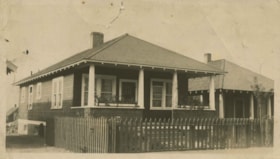
Ross Service Station, Douglas Road and Grandview Highway
https://search.heritageburnaby.ca/link/archivedescription37353
- Repository
- City of Burnaby Archives
- Date
- 1922 (date of original), copied [1998]
- Collection/Fonds
- Burnaby Historical Society fonds
- Description Level
- Item
- Physical Description
- 1 photograph : b&w ; 10 x 15 cm print
- Scope and Content
- Photograph of the Ross Service Station, located at Douglas road and Grandview Highway (now Canada Way). This station was built, owned and operated by Fred Ross.
- Repository
- City of Burnaby Archives
- Date
- 1922 (date of original), copied [1998]
- Collection/Fonds
- Burnaby Historical Society fonds
- Subseries
- Ross family subseries
- Physical Description
- 1 photograph : b&w ; 10 x 15 cm print
- Description Level
- Item
- Record No.
- 358-001
- Access Restriction
- No restrictions
- Reproduction Restriction
- No known restrictions
- Accession Number
- BHS1998-05
- Scope and Content
- Photograph of the Ross Service Station, located at Douglas road and Grandview Highway (now Canada Way). This station was built, owned and operated by Fred Ross.
- Names
- Ross Service Station
- Media Type
- Photograph
- Notes
- Title based on contents of photograph.
- The 1925 Burnaby Business Guide provides the address for this building as Douglas Road and Sprott Street.
- Geographic Access
- Douglas Road
- Sprott Street
- Canada Way
- Street Address
- 3355 Douglas Road
- Planning Study Area
- Douglas-Gilpin Area
Images
![Ross Service Station, Douglas Road and Grandview Highway, 1922 (date of original), copied [1998] thumbnail](/media/hpo/_Data/_Archives_Images/_Unrestricted/316/358-001.jpg)

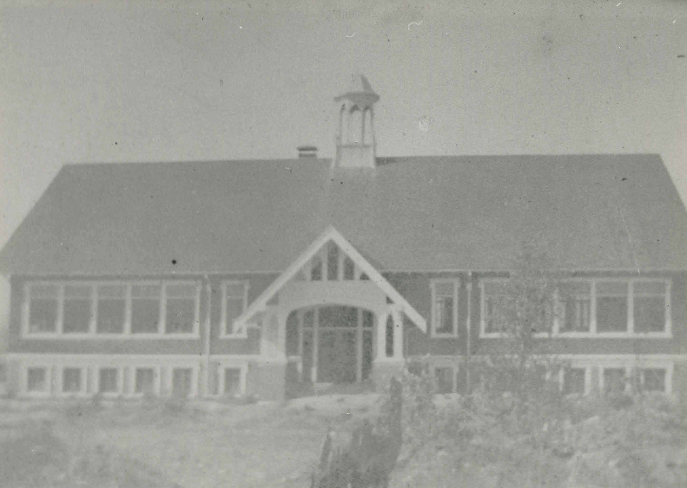
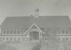
Schou Street School
https://search.heritageburnaby.ca/link/archivedescription37032
- Repository
- City of Burnaby Archives
- Date
- 1924 (date of original), copied 1992
- Collection/Fonds
- Burnaby Historical Society fonds
- Description Level
- Item
- Physical Description
- 1 photograph : b&w ; 10.1 x 14.9 cm print
- Scope and Content
- Photograph of the exterior of Schou Street School.
- Repository
- City of Burnaby Archives
- Date
- 1924 (date of original), copied 1992
- Collection/Fonds
- Burnaby Historical Society fonds
- Subseries
- Burnaby Centennial Anthology subseries
- Physical Description
- 1 photograph : b&w ; 10.1 x 14.9 cm print
- Description Level
- Item
- Record No.
- 315-495
- Access Restriction
- No restrictions
- Reproduction Restriction
- No known restrictions
- Accession Number
- BHS1994-04
- Scope and Content
- Photograph of the exterior of Schou Street School.
- Subjects
- Buildings - Schools
- Names
- Schou Street School
- Media Type
- Photograph
- Notes
- Title based on contents of photograph
- Geographic Access
- Grandview Highway
- Gilmore Avenue
- Canada Way
- Street Address
- 4054 Norfolk Street
- Historic Neighbourhood
- Broadview (Historic Neighbourhood)
- Planning Study Area
- Cascade-Schou Area
Images
Schou Street School
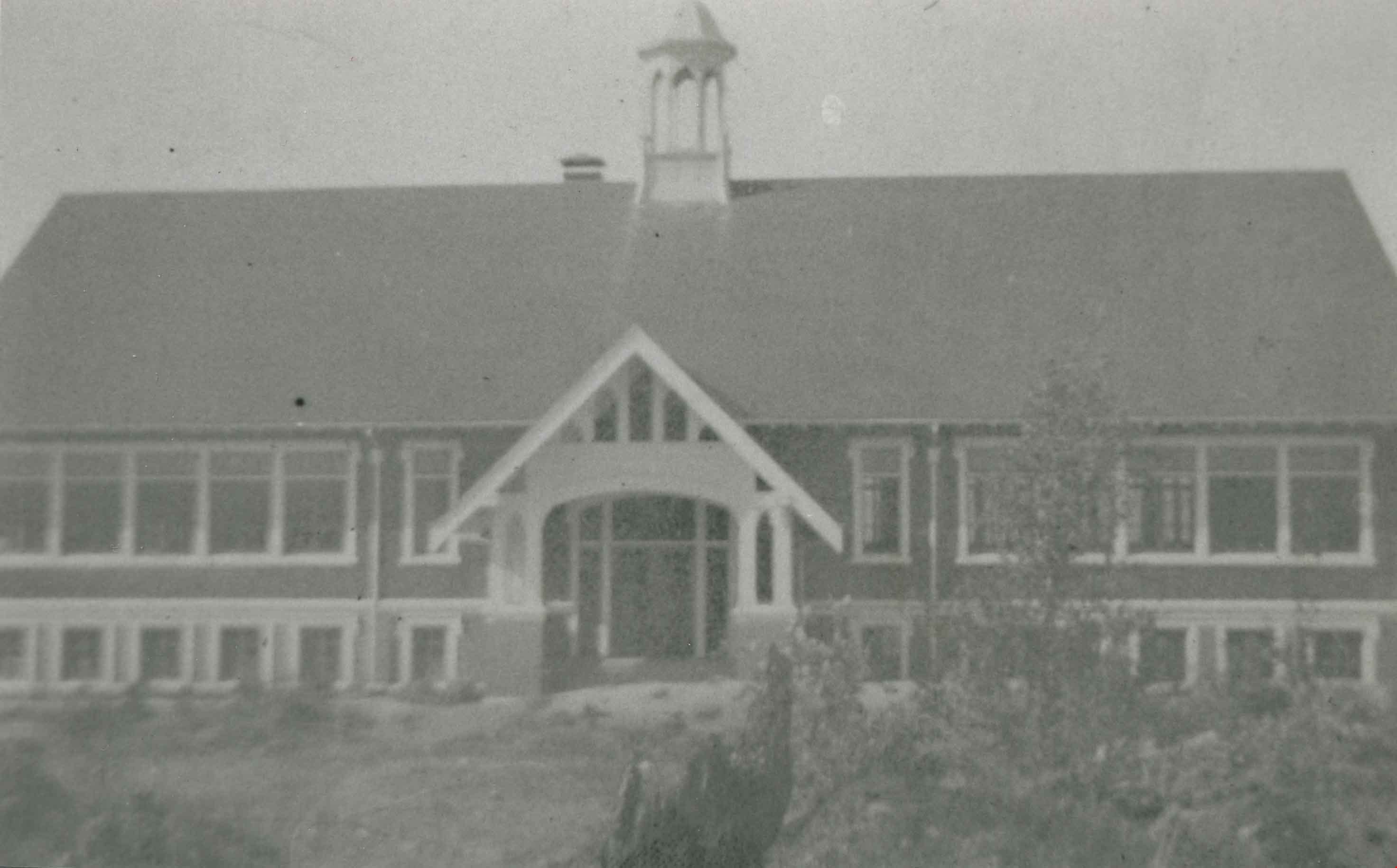
https://search.heritageburnaby.ca/link/archivedescription38250
- Repository
- City of Burnaby Archives
- Date
- 1924
- Collection/Fonds
- Burnaby Historical Society fonds
- Description Level
- Item
- Physical Description
- 1 photograph : b&w ; 9 x 12.5 cm
- Scope and Content
- Photograph of the Schou Street School.
- Repository
- City of Burnaby Archives
- Date
- 1924
- Collection/Fonds
- Burnaby Historical Society fonds
- Subseries
- Margaret McCallum subseries
- Physical Description
- 1 photograph : b&w ; 9 x 12.5 cm
- Description Level
- Item
- Record No.
- 375-011
- Access Restriction
- No restrictions
- Reproduction Restriction
- No known restrictions
- Accession Number
- BHS1986-42
- Scope and Content
- Photograph of the Schou Street School.
- Subjects
- Buildings - Schools
- Names
- Schou Street School
- Media Type
- Photograph
- Notes
- Title based on contents of photograph.
- Geographic Access
- Canada Way
- Street Address
- 4054 Norfolk Street
- Historic Neighbourhood
- Broadview (Historic Neighbourhood)
- Planning Study Area
- Cascade-Schou Area
Images