Narrow Results By
Subject
- Advertising Medium - Poster 1
- Advertising Medium - Signs and Signboards 59
- Agriculture 1
- Agriculture - Farms 1
- Arts - Paintings 1
- Buildings - Civic - Hospitals 1
- Buildings - Commercial 3
- Buildings - Commercial - Drugstores 1
- Buildings - Commercial - Grocery Stores 5
- Buildings - Commercial - Restaurants 4
- Buildings - Commercial - Service Stations 1
- Buildings - Commercial - Stores 1

Inkwells to Internet: A History of Burnaby Schools
https://search.heritageburnaby.ca/link/museumlibrary7551
- Repository
- Burnaby Village Museum
- Publication Date
- 2020
- Call Number
- 371 CAR
medals.
Sunshine Week was
a five day event. Students
signed up for one of a
myriad of activities that
were sponsored by teachers who had expertise in a
specific field. Some of these events were a boat cruise
to Galiano Island for a nature study, a cycling in Burnaby
tour, a wood-carving day lesson (as we
- Repository
- Burnaby Village Museum
- Collection
- Reference Collection
- Digital Reference Collection
- Material Type
- Book
- ISBN
- 978-0-9781979-2-6
- Call Number
- 371 CAR
- Place of Publication
- Burnaby
- Publisher
- City of Burnaby
- Publication Date
- 2020
- Physical Description
- vii, 35 p. : ill. ; 29 cm.
- Library Subject (LOC)
- Burnaby (B.C.)--History
- Schools--British Columbia--Burnaby
- Subjects
- Education
- Notes
- "Includes index"
- A history of the Burnaby school district and individual school buildings in Burnaby, BC, between 1893 and 2013.
- The “First Nations cemetery” described on page 109 in Mary Johnson’s recollections was originally written as “Indian” and may refer to the Khalsa Diwan Society’s Sikh cremations at the Vancouver Cemetery.
Images

Digital Books
![Survey and Subdivision plans in New Westminster District Group 1 – Burnaby
, [1861]-[1910] thumbnail](/media/hpo/_Data/_BVM_Cartographic_Material/1977/1977_0093_0019a_001.jpg?width=280)
Survey and Subdivision plans in New Westminster District Group 1 – Burnaby
https://search.heritageburnaby.ca/link/museumdescription6988
- Repository
- Burnaby Village Museum
- Date
- [1861]-[1910]
- Collection/Fonds
- Burnaby Village Museum Map collection
- Description Level
- File
- Physical Description
- 14 plans : 3 plans : black ink on paper hand col. + 7 plans : black ink on paper + 4 plans : graphite on paper mounted on 2 sides of cardboard 76 x 102 cm
- Scope and Content
- Item consists of a large board of four New Westminster District Gp 1 - subdivision plans mounted on one side and ten New Westminster District Gp 1 - subdivision plans mounted on the other side. Side A: 1. "Plan /of / Lots 166A, 166 and 167 /, Gr.1, N.W.D. / Showing Misconstructed Roads in Gree…
- Repository
- Burnaby Village Museum
- Collection/Fonds
- Burnaby Village Museum Map collection
- Description Level
- File
- Physical Description
- 14 plans : 3 plans : black ink on paper hand col. + 7 plans : black ink on paper + 4 plans : graphite on paper mounted on 2 sides of cardboard 76 x 102 cm
- Material Details
- Scales [between 1:2376 and 1:7920]
- Index number on edge of board reads: "19"
- Scope and Content
- Item consists of a large board of four New Westminster District Gp 1 - subdivision plans mounted on one side and ten New Westminster District Gp 1 - subdivision plans mounted on the other side. Side A: 1. "Plan /of / Lots 166A, 166 and 167 /, Gr.1, N.W.D. / Showing Misconstructed Roads in Green / 5 chs = 1 in.". (plan is drawn in black ink and hand coloured in red, green and orange ink). A section in the centre of the plan is coloured in red ink and identified as "C.S. Richmond" running from the North Arm of Fraser River to Wiggins Road and divided by "New Wiggins Rd. (as gazetted)" (coloured in orange ink) and two"Constructed Road(s)" (coloured in green ink). Plan is initialed by: "RB" [sic] (in blue pencil crayon) 2. Plan of / Subdivision of / Lot 166 / Group One / New Westminster District / Scale 4 chs = 1 in. / Map No 524". Plan is drawn in graphite and signed by "Surrig [sic] Welhams [sic] / P.L.S." Plan is initialed by: "RB" [sic] (in blue pencil crayon) 3. Plan of "Survey / of Highway / For / Burnaby Council / in / Lots 13 _14 / Group One / Scale 4 chs = 1 in." Signed by "Albert J. Hill, P.L.S." Caribou Street and Caribou Road run through the centre of the plan. Plan is stamped: "Albert J. Hill, Civil Engineer / and / Provincial Land Surveyor, / New Westminster, / B.C.". Plan is initialed by: "RB" [sic] (in blue pencil crayon) 4. A Plan of Lots 166A, 166 and 167, Group One, New Westminster District (drawn in graphite). A section in the centre of the plan is identified as "C.S. Richmond" running from the North Arm of Fraser River and divided by "New Wiggins Rd. (as gazetted)" and two "Constructed Road(s)". Plan is initialed by: "RB" [sic] (in blue pencil crayon) Side B: 1. Small plan drawn in black ink (no title) identifying lots north of the "North Arm" of the Fraser River. Lots identified include: Lot 99, Lot 98, Lot 157, Lot 158, Lot 163, Lot 162, Lot 159, Lot 163, Lot 162, Lot 165, Lot 166A, Lot 155B, Lot 155A and Lot 159. "Scale 40 chains to one inch" . Plan is initialed by: "RB" [sic] (in blue pencil crayon) (Geographic location: Burnaby) 2. Small plan drawn in black ink (no title) identifying lots north of the North Arm of the Fraser River as "Lots 155, 155A, 155B, 155C, 162, 163, 164, 165, 166A and 167". Plan is initialed by: "RB" [sic] (in blue pencil crayon) (Geographic location: Burnaby) 3. Small plan drawn in black ink (no title) which identifies "Lot 151 / Reserve/ for / Race Course"; "Reserve / 64 A / L. 152 G.1"; and other Lots: 32, 33, 34, 35, 36, 38, 39. The plan is signed "Surveyor G.Turn [sic] July / 61 / from Vol 40 R.L. notes [sic]" Plan is stamped: "Albert J. Hill, Civil Engineer / and / Provincial Land Surveyor, / New Westminster, / B.C." Plan is initialed by: "RB" [sic] (in blue pencil crayon) (Geographic location: Burnaby) 4. Small plan drawn in black in with faded red colouring on centre lot identified as "Lot 34" running north from "Vancouver Road" . Plan is stamped: "Albert J. Hill, Civil Engineer / and / Provincial Land Surveyor, / New Westminster, / B.C." Plan is initialed by: "RB" [sic] (in blue pencil crayon) (Geographic location: Burnaby) 5. Plan drawn in graphite and identified as "Lot 98, Gr.1," along with the intials "RB" [sic] (both are handwritten in blue crayon pencil on top of plan) The B.C.E.Railway is identified running through the plan along with Jubilee Road and Royal Oak Road. The plan is signed with the name "Wm. Murray" and the Plan is stamped: "Albert J. Hill, Civil Engineer / and / Provincial Land Surveyor, / New Westminster, / B.C.". (Geographic location: Burnaby) 6. Plan drawn in graphite identified as "Port Lot 13, Gr.1" along with the intials "RB" [sic] (both are handwritten in blue crayon pencil on top of plan) Plan is stamped: "Albert J. Hill, Civil Engineer / and / Provincial Land Surveyor, / New Westminster, / B.C.". (Geographic location: Burnaby) 7.Plan drawn in black ink and identified as "Lot 98 G.1" along with the intials "RB" [sic] (both are handwritten in blue crayon pencil on top of plan). A "Road Reservation" is identified running north between "Electric Tramway" and connecting with "Royal Oak Road". Plan is stamped: "Albert J. Hill, Civil Engineer / and / Provincial Land Surveyor, / New Westminster, / B.C." (Geographic location: Burnaby) 8. Plan drawn in black ink and divided into two sections, the upper plan is identified as "Portion / Lots 100 / area / 101, Gr.1" and the lower plan is identified as "Portion L. 3 G. 1" along with the intials "RB" [sic] (these identifiers are handwritten in blue crayon pencil on top of the plan). Portions of Lot 100 and Lot 101 are each divided into 6 sections and the Portion of Lot 3 plan is divided into 24 sections. The plan includes a note in black ink that reads: " Received from Wm Fromme [sic] / from Wm. Trapp / Nov. 28, 1895 / A. J. T...[sic]". (Geographic location: Burnaby) 9. Plan drawn in black ink (no title) identifying soil, buildings and geographic features in southern Burnaby. The plan is bordered by "New Westminster City" (Tenth Avenue and DL 172) to the south east and DL 173 to the south, DL 158 to the west and the B.C.E. Tramway to the north. Plan includes District Lots: 155A, 158, 159, 171, 160, 53 and 95 and identifies soil, marshland and ravines throughout. Plan identifies the following features: a "Team Road" running through Lots 158 and 159 along with "Fair Orchard Soil / Even Surface Throughout / No Ravines", "Gravel and Shingle" (bottom of Lot 158), "North Arm Road" crossing "Byrne Road" and connecting with "Power House Road" which runs north to connect with "Highland Park Station" and the B.C.E. Tramway, "Power Ho" in the northeast corner of DL 160, a "Brook" connected with a "Deep Ravine" running between DL 53, DL 95 and DL 160 along with "Good Soil" and "Fair Orchard Soil" identified nearby in DL 95. Scale is identified as "10 chs = 1 in." Plan is stamped: "Albert J. Hill, Civil Engineer / and / Provincial Land Surveyor, / New Westminster, / B.C." Plan is initialed by: "RB" [sic] (in blue pencil crayon) (Geographic location: Burnaby) 10. Plan drawn in black ink (no title) with Burnaby Lake and Deer Lake at the centre. The plan is bordered by the following District Lots identified as: 117, 118 and 68 to the west, Lots 80, 79 and 85 to the southwest, Lots 11, 13, and 1 (City of New Westminster) to the south east, the North Road boundary to the east and Lots 8, 56, 57, 59, and 136 to the North. The lower right hand corner of the plan has a small inset which reads: "Burnaby Lake" and "Page 19 R.B. Notes". Plan is initialed by: "RB" [sic] (in blue pencil crayon) (Geographic location: Burnaby)
- Creator
- Hill, Albert James
- Accession Code
- HV977.93.19
- Access Restriction
- No restrictions
- Reproduction Restriction
- No known restrictions
- Date
- [1861]-[1910]
- Media Type
- Cartographic Material
- Scan Resolution
- 300
- Scale
- 72
- Notes
- Title based on contents of file
- Scale is measured in chains. (One chain equals 792 inches)
- The term "Lot" can also refer to a "District Lot”
- Some plans are stamped: "Albert J. Hill, Civil Engineer / and / Provincial Land Surveyor, / New Westminster, / B.C." and intialed: "RB" [sic]
Images
![Survey and Subdivision plans in New Westminster District Group 1 – Burnaby
, [1861]-[1910] thumbnail](/media/hpo/_Data/_BVM_Cartographic_Material/1977/1977_0093_0019a_001.jpg)

![Survey and Subdivision plans in New Westminster District Group 1 – Burnaby, Port Moody, [1862-1908] thumbnail](/media/hpo/_Data/_BVM_Cartographic_Material/1977/1977_0093_0026a_001.jpg?width=280)
Survey and Subdivision plans in New Westminster District Group 1 – Burnaby, Port Moody
https://search.heritageburnaby.ca/link/museumdescription6995
- Repository
- Burnaby Village Museum
- Date
- [1862-1908]
- Collection/Fonds
- Burnaby Village Museum Map collection
- Description Level
- File
- Physical Description
- 9 plans : 6 plans : black ink on paper ; 57 x 36.5 cm or smaller + 1 plan : black ink and grahite on paper ; 46.5 x 49 cm + 1 plan : blueprint on paper ; 15.5 x 19.5 cm + cm + 1 plan : graphite on paper ; 25 x 17 cm ; mounted on both sides of board 76 x 102 cm
- Scope and Content
- Item consists of a large board of four New Westminster District subdivision plans mounted on one side and five New Westminster District subdivision plans mounted on the other side. Side A: 1. "Plan / of Subdivision / of a Portion / of / Lot 87 / Group One / New Westminster District / Scale 4 chs…
- Repository
- Burnaby Village Museum
- Collection/Fonds
- Burnaby Village Museum Map collection
- Description Level
- File
- Physical Description
- 9 plans : 6 plans : black ink on paper ; 57 x 36.5 cm or smaller + 1 plan : black ink and grahite on paper ; 46.5 x 49 cm + 1 plan : blueprint on paper ; 15.5 x 19.5 cm + cm + 1 plan : graphite on paper ; 25 x 17 cm ; mounted on both sides of board 76 x 102 cm
- Material Details
- Scales [between 1:792 and 1:3600]
- Index number on edge of board reads: "26"
- Scope and Content
- Item consists of a large board of four New Westminster District subdivision plans mounted on one side and five New Westminster District subdivision plans mounted on the other side. Side A: 1. "Plan / of Subdivision / of a Portion / of / Lot 87 / Group One / New Westminster District / Scale 4 chs = 1 in". Plan is stamped: "Albert J. Hill, Civil Engineer / and / Provincial Land Surveyor, / New Westminster, / B.C." and intialed by: "RB" [sic] (in blue pencil crayon). Names two of the subdivisons of District Lot 87 are identified as, "L.E. Sprott" and "John Ledger". (Geographic location: Burnaby) 2. "Plan of Subdivision / of / Portions of / Lot 136, 131 and Lots 44 and 78 Gr.1 / New Westminster District / Scale 300 ft = 1 inch". Annotation above title reads: "No. 901 / Deposited in Land Registry Office / New Westminster / Aug. 19th 1905 / Charles S. Keith D. Reg." Annotations and signatures at bottom of plan read: "I, William Nelson Draper, / W.H.R. Collister / Charles E. Perkins / E.B. Morgan / make / Surveys / correct / representation / upon / the / Land Registry Act / (sgd) W.N. Draper, P.L.S.". Plan includes a handwritten title: "Lots 136, 131, 44 & 78" and is initialed: "RB" [sic] (in blue pencil crayon) (Geographic location: Burnaby) 3. "Survey / of / a Portion / of / Lot 95, Gr.1 / Scale 1 ch = 1in." Plan is stamped: "Albert J. Hill, Civil Engineer / and / Provincial Land Surveyor, / New Westminster, / B.C." and is initialed : "RB" [sic] (in blue pencil crayon) (Geographic location: Burnaby) 4. Blueprint plan of "Lot 396. Group One." with Scale : 3 chs = 1 in. A two acre portion of District Lot 396 is filled in with red ink." Plan is signed by "Albert J. Hill / B.C.L.S." (Geographic location: Port Moody) Side B: 1. Plan titled "District Lot 92 / Burnaby / Municipality / for sale by / Mahon / McFarland & / Mahon Ltd. / Vancouver, B.C. / Scale : 4 chains to one inch". District Lot 92 is subdivided into 161 lots and identifies roads: Norwich Road, Pole Line Road, Oakland Road, Stanley Road, Burford Road, Dalhousie Road, Brantford Road, Colborne Road, Roberts Road, Vancouver & Westminster Road, B.C. Electric Railway, Gilley Stn. and Burnaby (Power House). The bottom of the plan reads: "G.S. Dawson, P.LS. Vancouver, B.C." (Geographic location: Burnaby) 2. "Plan / of Subdivision / of a Portion / of / Lot 29 / Group 1 / New Westminster District / Scale 2 chs = 1 in". Plan is stamped: "Albert J. Hill, Civil Engineer / and / Provincial Land Surveyor, / New Westminster, / B.C." and is initialed by: "RB" [sic] (in blue pencil crayon) (Geographic location: Burnaby) 3. Small handrawn plan (no title) identifying "Lot 84 / Hydes, Claim" at the centre surrounded by lots and features identified as: "Lot 85", "Lot 93", "Lot 94", "Lot 32", "Lot 82", "Lot 83", "Lot 79", "swamp" and a "Small Lake" (Burnaby Lake). Identifying marks in the right corner of the plan read: "Page 13 / Surveyed by G. Turner / May 62". Plan also includes surveyor's bearing measurements and trails to "Small Lake" (Burnaby Lake). (Geographic location: Burnaby) 4. Untitled plan showing District Lots west of North Road and north of Burnaby Lake including: Lots 2, 4, 6, 8, 15, 10, 56, 148, 57, 58, 40. and Lots 3, 5, 7 east of North Road (Coquitlam). Lots in Burnaby are identifed for timber including: "Heavily Timbered" (Lot 57), " "Some Fir and Cedar" (Lot 40), "Splendid Fir and Cedar" (Lot 143), "Heavy Fir etc" (Lots 143 and 148), " "Fine Cedar" (Lot 15), "Rough Light Timber" (Lot 56). Other features identified at the lower portion of the plan include "Burnaby Lake" and "Brunette River". (Geographic location: Burnaby) 5. Untitled plan drawn in graphite showing sections of District Lot 85 south of Burnaby Lake and north of Hazsard Road. Plan is signed: "Albert J. Hill / B.C.L.S." and dated "12/26/08". Plan is initialed by: "RB" [sic] (in blue pencil crayon) (Geographic location: Burnaby)
- Publisher
- Mahon, McFarland & Mahon Ltd
- Accession Code
- HV977.93.26
- Access Restriction
- No restrictions
- Reproduction Restriction
- No known restrictions
- Date
- [1862-1908]
- Media Type
- Cartographic Material
- Historic Neighbourhood
- Burnaby Lake (Historic Neighbourhood)
- Burquitlam (Historic Neighbourhood)
- Planning Study Area
- Burnaby Lake Area
- Scan Resolution
- 300
- Scale
- 72
- Notes
- Title based on contents of file
- Scale is measured in chains and feet. (One chain equals 792 inches)
- The term "Lot" can also refer to a "District Lot”
Images
![Survey and Subdivision plans in New Westminster District Group 1 – Burnaby, Port Moody, [1862-1908] thumbnail](/media/hpo/_Data/_BVM_Cartographic_Material/1977/1977_0093_0026a_001.jpg)


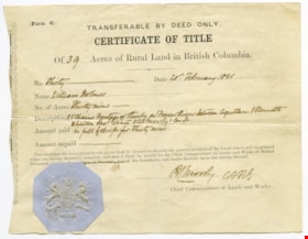
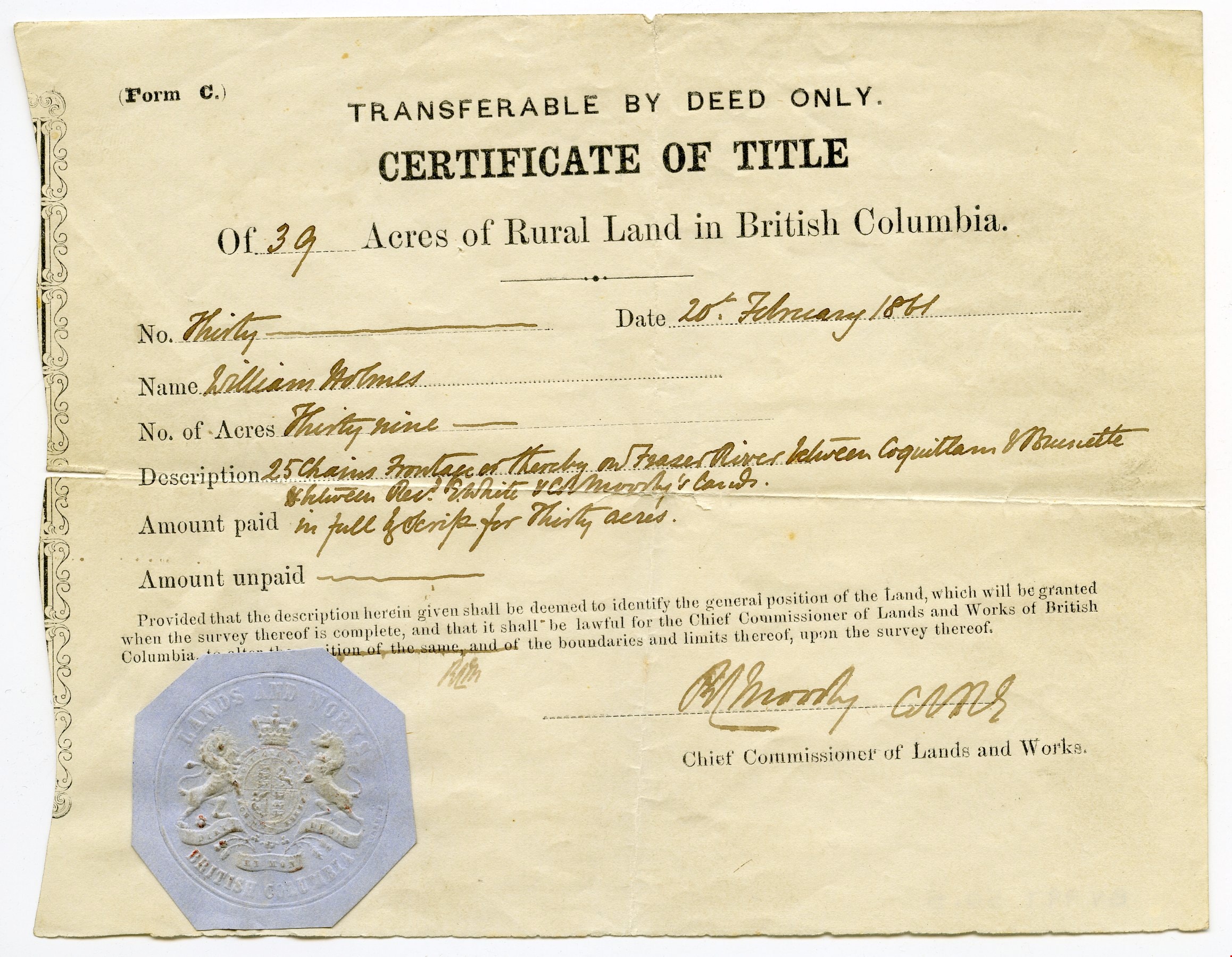
Certificate of Title
https://search.heritageburnaby.ca/link/museumdescription10407
- Repository
- Burnaby Village Museum
- Date
- 20 Feb. 1861
- Collection/Fonds
- William Holmes fonds
- Description Level
- Item
- Physical Description
- 1 certificate
- Scope and Content
- Item consists of "Certificate of Title" to Mr. William Holmes for land in Burnaby/NE Westminster; "39 Acres", "20th February 1861". "Description" reads: "25 Chains Frontage on thereby on Fraser River between Coquitlam & Brunette / between Rev. E. White & Col. Moody's [?]". The blue Provincial seal…
- Repository
- Burnaby Village Museum
- Collection/Fonds
- William Holmes fonds
- Description Level
- Item
- Physical Description
- 1 certificate
- Scope and Content
- Item consists of "Certificate of Title" to Mr. William Holmes for land in Burnaby/NE Westminster; "39 Acres", "20th February 1861". "Description" reads: "25 Chains Frontage on thereby on Fraser River between Coquitlam & Brunette / between Rev. E. White & Col. Moody's [?]". The blue Provincial seal is affixed to the certificate and it is signed by R.C. Moody, "Chief Commissioner of Lands and Works".
- Accession Code
- BV997.50.5
- Access Restriction
- No restrictions
- Reproduction Restriction
- No known restrictions
- Date
- 20 Feb. 1861
- Media Type
- Textual Record
- Scan Resolution
- 300
- Scan Date
- 06-May-2019
- Notes
- Title based on contents of item
Images
Certificate of Title
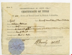
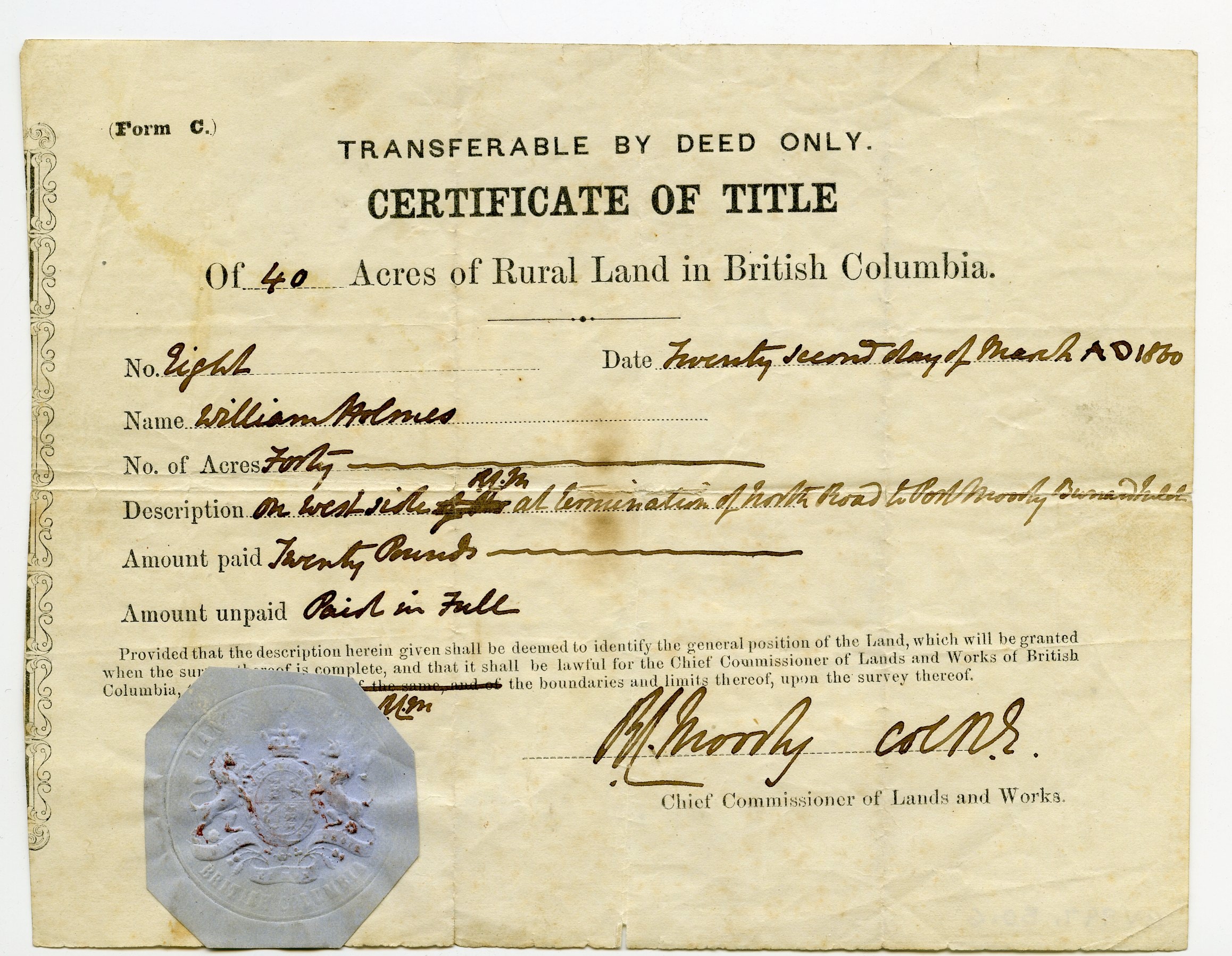
https://search.heritageburnaby.ca/link/museumdescription10408
- Repository
- Burnaby Village Museum
- Date
- 22 Mar. 1860
- Collection/Fonds
- William Holmes fonds
- Description Level
- Item
- Physical Description
- 1 certificate
- Scope and Content
- Item consists of "Certificate of Title" to Mr. William Holmes for land in Burnaby/NE Westminster; "40 Acres", "Twenty Second Day of March AD 1860". Description reads: "On West Side at termination of North Road to Port Moody Burrard Inlet". The blue Provincial seal is affixed to the certificate and…
- Repository
- Burnaby Village Museum
- Collection/Fonds
- William Holmes fonds
- Description Level
- Item
- Physical Description
- 1 certificate
- Scope and Content
- Item consists of "Certificate of Title" to Mr. William Holmes for land in Burnaby/NE Westminster; "40 Acres", "Twenty Second Day of March AD 1860". Description reads: "On West Side at termination of North Road to Port Moody Burrard Inlet". The blue Provincial seal is affixed to the certificate and it is signed by R.C. Moody, "Chief Commissioner of Lands and Works".
- Accession Code
- BV997.50.6
- Access Restriction
- No restrictions
- Reproduction Restriction
- No known restrictions
- Date
- 22 Mar. 1860
- Media Type
- Textual Record
- Scan Resolution
- 300
- Scan Date
- 06-May-2019
- Notes
- Title based on contents of item
Images
Certificate of Title
https://search.heritageburnaby.ca/link/museumdescription10409
- Repository
- Burnaby Village Museum
- Date
- 22 Mar. 1860
- Collection/Fonds
- William Holmes fonds
- Description Level
- Item
- Physical Description
- 1 certificate
- Scope and Content
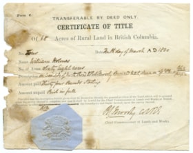
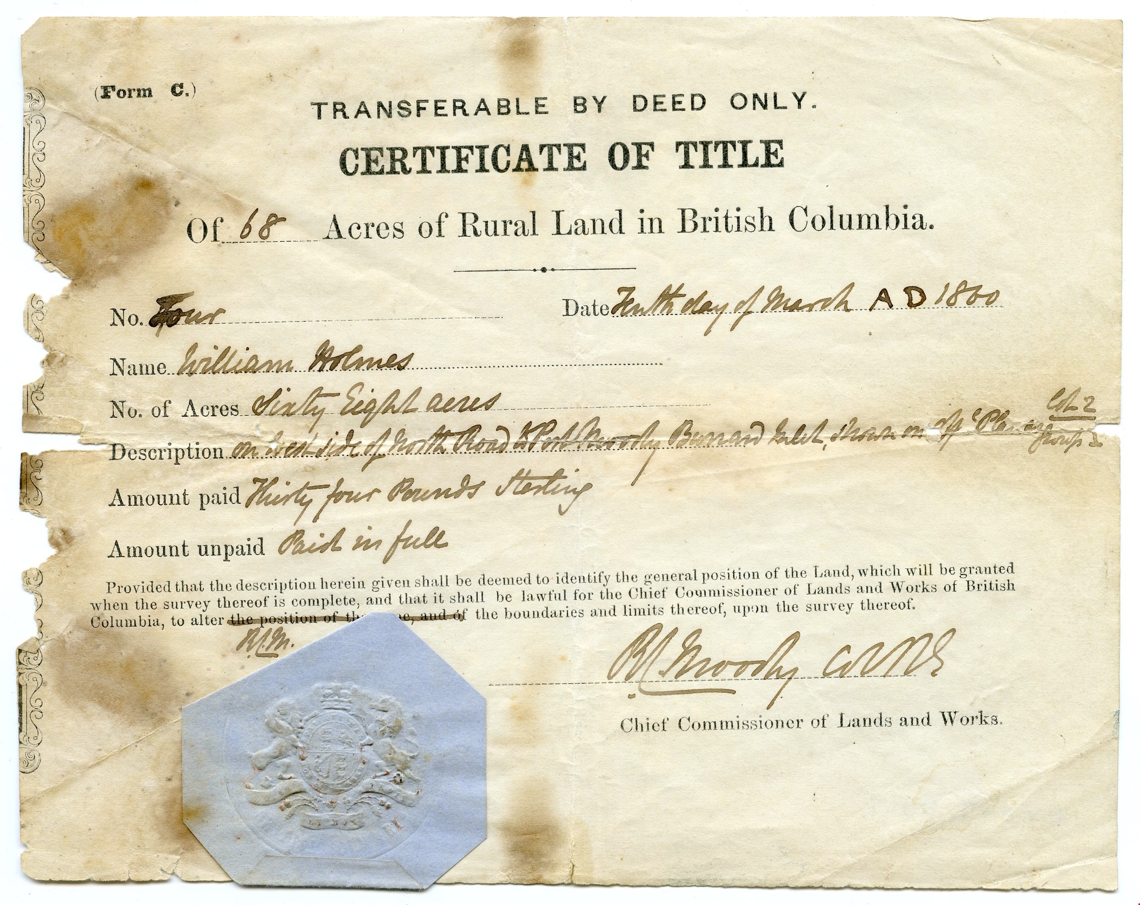
- Item consists of "Certificate of Title" to Mr. William Holmes for land in Burnaby/NE Westminster; "68 Acres", "Tenth Day of March AD 1860". Description reads: "On West Side of North Road to Port Moody Burrard Inlet, shown on the [?] Plan as Lots 2 / Group 1". The blue Provincial seal is affixed to…
- Repository
- Burnaby Village Museum
- Collection/Fonds
- William Holmes fonds
- Description Level
- Item
- Physical Description
- 1 certificate
- Scope and Content
- Item consists of "Certificate of Title" to Mr. William Holmes for land in Burnaby/NE Westminster; "68 Acres", "Tenth Day of March AD 1860". Description reads: "On West Side of North Road to Port Moody Burrard Inlet, shown on the [?] Plan as Lots 2 / Group 1". The blue Provincial seal is affixed to the certificate and it is signed by R.C. Moody "Chief Commissioner of Lands and Works".
- Accession Code
- BV997.50.7
- Access Restriction
- No restrictions
- Reproduction Restriction
- No known restrictions
- Date
- 22 Mar. 1860
- Media Type
- Textual Record
- Scan Resolution
- 300
- Scan Date
- 06-May-2019
- Notes
- Title based on contents of item
Images

Cigarette price sign inside of Canada Way Food Market
https://search.heritageburnaby.ca/link/museumdescription20349
- Repository
- Burnaby Village Museum
- Date
- 13 Jun. 2023
- Collection/Fonds
- Harry Toy fonds
- Description Level
- Item
- Physical Description
- 1 photograph (jpg) : col.
- Scope and Content
- Photograph of cigarette price display sign hanging from ceiling inside of the Canada Way Food Market located at 4694 Canada Way, Burnaby. Boxes are visible beneath the sign. The food market closed in 2010.
- Repository
- Burnaby Village Museum
- Collection/Fonds
- Harry Toy fonds
- Series
- Harry Toy photographs series
- Description Level
- Item
- Physical Description
- 1 photograph (jpg) : col.
- Scope and Content
- Photograph of cigarette price display sign hanging from ceiling inside of the Canada Way Food Market located at 4694 Canada Way, Burnaby. Boxes are visible beneath the sign. The food market closed in 2010.
- Subjects
- Buildings - Commercial - Stores
- Names
- Canada Way Food Market
- Geographic Access
- Canada Way
- Street Address
- 4694 Canada Way
- Accession Code
- BV023.25.1
- Access Restriction
- No restrictions
- Reproduction Restriction
- No known restrictions
- Date
- 13 Jun. 2023
- Media Type
- Photograph
- Related Material
- BV023.16.19 - Interview with Harry Toy, Beverley Babey and Christina Toy
- BV023.17.3 - Cigarette price display sign
- For associated artifacts from Canada Way Food Market see Accession BV023.17
- Scan Date
- 2023-06-13
- Photographer
- Petrusa, Kate
- Notes
- Title based on contents of photograph
- The sign was donated to the Burnaby Village Museum in 2023
Images


Rooted : Chinese Canadian stories in Burnaby
https://search.heritageburnaby.ca/link/museumlibrary7646
- Repository
- Burnaby Village Museum
- Collection
- Digital Reference Collection
- Material Type
- Digital Resource
- ISBN
- 978-0-9689849-2-5
- Call Number
- 971.133 ROO
- Contributor
- Fong, Denise
- Lemke, Jane
- Codd, Lisa
- Place of Publication
- Burnaby
- Publisher
- City of Burnaby
- Publication Date
- 2023
- Printer
- Metropolitan Fine Printers
- Physical Description
- 203 p. : ill. ; 30.5 cm
- Library Subject (LOC)
- Chinese Canadians--British Columbia--Burnaby--History
- Race discrimination -- Canada
- Subjects
- Persons - Chinese Canadians
- Agriculture
- Agriculture - Farms
- Persons - Families
- Rights
- Rights - Human Rights
- Social Issues
- Social Issues - Racism
- Notes
- There are two versions of the book: English and Simplified Chinese (left, below) and the other in English and Traditional Chinese (right, below).
- From the late 1800s to the present day, Chinese Canadians have made Burnaby into a more vibrant and livable city. Rooted: Chinese Canadian Stories in Burnaby brings together a collection of diverse stories and photographs from the community, celebrating the legacy and contributions of Burnaby’s Chinese Canadian community spanning over a century. This coffee-table book features oral histories and interviews with descendants of multigenerational family farms, green grocers, corner stores, restaurants, and places of worship. Also included are archival research and community perspectives on anti-Asian racism, community activism, courage, and resilience.
- The publication has been timed to coincide with the 100th anniversary of the introduction of the Chinese Exclusion Act by the Government of Canada in 1923. This federal legislation followed decades of discriminatory legislation by Canada’s federal, provincial and municipal governments that targeted Chinese Canadians by limiting opportunities to live, work and raise families in Canada. The Chinese Exclusion Act banned almost all migration from China and remained in place until 1947. Publishing this book in 2023 is an effort by the City of Burnaby to recognize the impact of discriminatory legislation on Chinese Canadians in our community, including discriminatory bylaws and practices implemented by Burnaby’s early municipal government.
- Edited by Denise Fong (Lead Researcher), Jane Lemke (Burnaby Village Museum Curator) and Lisa Codd (City of Burnaby Heritage Planner).
Images

Digital Books

Temporary one way at Deer Lake Park
https://search.heritageburnaby.ca/link/archivedescription95111
- Repository
- City of Burnaby Archives
- Date
- April 10, 2020
- Collection/Fonds
- Burnaby Photographic Society fonds
- Description Level
- Item
- Physical Description
- 1 photograph (tiff)
- Scope and Content
- Photograph of a sign detailing a temporary one-way walking route for Deer Lake Park. The sign is posted at the Royal Oak entrance of the park.
- Repository
- City of Burnaby Archives
- Date
- April 10, 2020
- Collection/Fonds
- Burnaby Photographic Society fonds
- Physical Description
- 1 photograph (tiff)
- Description Level
- Item
- Record No.
- 623-029
- Access Restriction
- No restrictions
- Reproduction Restriction
- No restrictions
- Accession Number
- 2020-10
- Scope and Content
- Photograph of a sign detailing a temporary one-way walking route for Deer Lake Park. The sign is posted at the Royal Oak entrance of the park.
- Media Type
- Photograph
- Photographer
- Snowdon, Nick
- Notes
- Transcribed title
- Photographer's caption: "Big signs show the one way system at Deer Lake. The signs are not detailed and lead to some confusion. Other signs are spread throughout the park including spay paint on the trails."
- Geographic Access
- Deer Lake Park
- Planning Study Area
- Windsor Area
Images


COVID-19 sign in Conderation Park
https://search.heritageburnaby.ca/link/museumdescription15363
- Repository
- Burnaby Village Museum
- Date
- 6 May 2020
- Collection/Fonds
- Burnaby Village Museum COVID-19 collection
- Description Level
- Item
- Physical Description
- 1 photograph (jpg)
- Scope and Content
- Photograph of a City of Burnaby COVID-19 sign in Confederation Park. Sign is attached to a tree near the running track and reads: "Do your part, Stay Apart..." and includes an illustration of two figures standing two metres apart. People are walking and running on the track and the tennis and baske…
- Repository
- Burnaby Village Museum
- Collection/Fonds
- Burnaby Village Museum COVID-19 collection
- Description Level
- Item
- Physical Description
- 1 photograph (jpg)
- Scope and Content
- Photograph of a City of Burnaby COVID-19 sign in Confederation Park. Sign is attached to a tree near the running track and reads: "Do your part, Stay Apart..." and includes an illustration of two figures standing two metres apart. People are walking and running on the track and the tennis and basketball courts are visible in the distance.
- Geographic Access
- Albert Street
- Confederation Park
- Accession Code
- BV021.2.25
- Access Restriction
- No restrictions
- Reproduction Restriction
- May be restricted by third party rights
- Date
- 6 May 2020
- Media Type
- Photograph
- Planning Study Area
- Sperling-Broadway Area
- Notes
- Title based on contents of photograph
Images


Do Your Part Eagle
https://search.heritageburnaby.ca/link/archivedescription95084
- Repository
- City of Burnaby Archives
- Date
- June 13, 2020
- Collection/Fonds
- Burnaby Photographic Society fonds
- Description Level
- Item
- Physical Description
- 1 photograph (tiff)
- Scope and Content
- Photograph of a sign along the Burnaby Lake Freeway Trail that reads: "Do your part. Stay 2 metres apart." The sign has a silhoutte drawing of an eagle with its wings open to illustrate the distance of two metres.
- Repository
- City of Burnaby Archives
- Date
- June 13, 2020
- Collection/Fonds
- Burnaby Photographic Society fonds
- Physical Description
- 1 photograph (tiff)
- Description Level
- Item
- Record No.
- 623-003
- Access Restriction
- No restrictions
- Reproduction Restriction
- No restrictions
- Accession Number
- 2020-10
- Scope and Content
- Photograph of a sign along the Burnaby Lake Freeway Trail that reads: "Do your part. Stay 2 metres apart." The sign has a silhoutte drawing of an eagle with its wings open to illustrate the distance of two metres.
- Media Type
- Photograph
- Photographer
- Gervan, Bonnie
- Notes
- Transcribed title
- Photographer's caption: "A sign shows how far to keep apart."
- Geographic Access
- Burnaby Lake Regional Nature Park
- Historic Neighbourhood
- Burnaby Lake (Historic Neighbourhood)
- Planning Study Area
- Burnaby Lake Area
Images


Facility closure sign in Conderation Park
https://search.heritageburnaby.ca/link/museumdescription15362
- Repository
- Burnaby Village Museum
- Date
- 6 May 2020
- Collection/Fonds
- Burnaby Village Museum COVID-19 collection
- Description Level
- Item
- Physical Description
- 1 photograph (jpg)
- Scope and Content
- Photograph of a City of Burnaby facility closure sign at Confederation Park. Sign is attached to a pole in the park and reads: "This Facility is closed until further notice". The McGill Library and City of Burnaby Archives building are visible to the north.
- Repository
- Burnaby Village Museum
- Collection/Fonds
- Burnaby Village Museum COVID-19 collection
- Description Level
- Item
- Physical Description
- 1 photograph (jpg)
- Scope and Content
- Photograph of a City of Burnaby facility closure sign at Confederation Park. Sign is attached to a pole in the park and reads: "This Facility is closed until further notice". The McGill Library and City of Burnaby Archives building are visible to the north.
- Geographic Access
- Albert Street
- Confederation Park
- Accession Code
- BV021.2.26
- Access Restriction
- No restrictions
- Reproduction Restriction
- May be restricted by third party rights
- Date
- 6 May 2020
- Media Type
- Photograph
- Planning Study Area
- Sperling-Broadway Area
- Notes
- Title based on contents of photograph
Images


Hopeful sign on Smith Ave
https://search.heritageburnaby.ca/link/archivedescription95099
- Repository
- City of Burnaby Archives
- Date
- March 21, 2020
- Collection/Fonds
- Burnaby Photographic Society fonds
- Description Level
- Item
- Physical Description
- 1 photograph (tiff)
- Scope and Content
- Photograph of a bright pink sign stapled to a telphone poll on Smith Avenue near Wakefield Court. A smiling green creature is painted on the sign along with the message "Stay Happy Stay Healthy!".
- Repository
- City of Burnaby Archives
- Date
- March 21, 2020
- Collection/Fonds
- Burnaby Photographic Society fonds
- Physical Description
- 1 photograph (tiff)
- Description Level
- Item
- Record No.
- 623-018
- Access Restriction
- No restrictions
- Reproduction Restriction
- No restrictions
- Accession Number
- 2020-10
- Scope and Content
- Photograph of a bright pink sign stapled to a telphone poll on Smith Avenue near Wakefield Court. A smiling green creature is painted on the sign along with the message "Stay Happy Stay Healthy!".
- Media Type
- Photograph
- Photographer
- Damer, Eric
- Notes
- Transcribed title
- Geographic Access
- Smith Avenue
- Planning Study Area
- Cascade-Schou Area
Images


Lost in the 50's Drive-In sign
https://search.heritageburnaby.ca/link/archivedescription98682
- Repository
- City of Burnaby Archives
- Date
- 2022
- Collection/Fonds
- Disappearing Burnaby collection
- Description Level
- Item
- Physical Description
- 1 photograph (jpeg) : col.
- Scope and Content
- Photograph of the historic "Arrow Neon Sign" at 50's Burgers, a restaurant located at 7741 Edmonds Street. The photograph depicts the sign, which reads: "Lost in the 50's Drive-In," against the sky at dusk.
- Repository
- City of Burnaby Archives
- Date
- 2022
- Collection/Fonds
- Disappearing Burnaby collection
- Physical Description
- 1 photograph (jpeg) : col.
- Description Level
- Item
- Record No.
- 634-029
- Access Restriction
- No restrictions
- Reproduction Restriction
- No restrictions
- Accession Number
- 2022-14
- Scope and Content
- Photograph of the historic "Arrow Neon Sign" at 50's Burgers, a restaurant located at 7741 Edmonds Street. The photograph depicts the sign, which reads: "Lost in the 50's Drive-In," against the sky at dusk.
- Media Type
- Photograph
- Photographer
- Cheung, Nakita
- Notes
- Title taken from the associated blog post
- Associated blog post: https://disappearingburnaby.wordpress.com/2022/06/30/lost-in-the-50s-drive-in/
- Geographic Access
- Edmonds Street
- Street Address
- 7741 Edmonds Street
- Historic Neighbourhood
- East Burnaby (Historic Neighbourhood)
- Planning Study Area
- Lakeview-Mayfield Area
Images

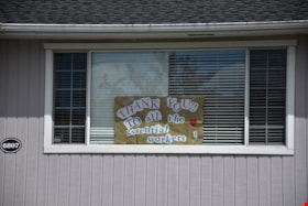
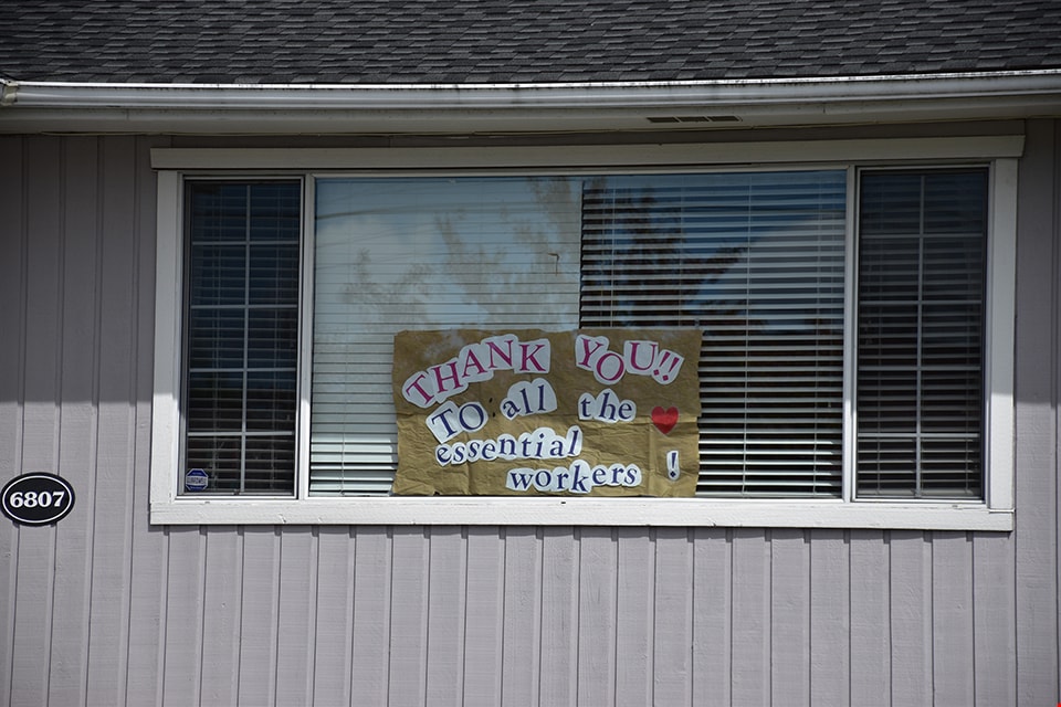
Thank you sign
https://search.heritageburnaby.ca/link/museumdescription15364
- Repository
- Burnaby Village Museum
- Date
- 6 May 2020
- Collection/Fonds
- Burnaby Village Museum COVID-19 collection
- Description Level
- Item
- Physical Description
- 1 photograph (jpg)
- Scope and Content
- Photograph of a handmade sign inside a window of a house. The sign includes a heart and reads "Thank You!! To all the essential workers!"
- Repository
- Burnaby Village Museum
- Collection/Fonds
- Burnaby Village Museum COVID-19 collection
- Description Level
- Item
- Physical Description
- 1 photograph (jpg)
- Scope and Content
- Photograph of a handmade sign inside a window of a house. The sign includes a heart and reads "Thank You!! To all the essential workers!"
- Subjects
- Advertising Medium - Signs and Signboards
- Public Services - Health Services
- Pandemics - COVID-19
- Accession Code
- BV021.2.24
- Access Restriction
- No restrictions
- Reproduction Restriction
- May be restricted by third party rights
- Date
- 6 May 2020
- Media Type
- Photograph
- Historic Neighbourhood
- Capitol Hill (Historic Neighbourhood)
- Planning Study Area
- Capitol Hill Area
- Notes
- Title based on contents of photograph
Images

Burnaby hospital closes main entrance
https://search.heritageburnaby.ca/link/archivedescription95094
- Repository
- City of Burnaby Archives
- Date
- April 6, 2020
- Collection/Fonds
- Burnaby Photographic Society fonds
- Description Level
- Item
- Physical Description
- 1 photograph (tiff)
- Scope and Content
- Photograph of a rerouting sign posted to a sandwich board outside the Burnaby Hospital emergency lot. The sign states that the hospital entrance is closed and requests visitors use the Main Entrance of the hospital.
- Repository
- City of Burnaby Archives
- Date
- April 6, 2020
- Collection/Fonds
- Burnaby Photographic Society fonds
- Physical Description
- 1 photograph (tiff)
- Description Level
- Item
- Record No.
- 623-013
- Access Restriction
- No restrictions
- Reproduction Restriction
- No restrictions
- Accession Number
- 2020-10
- Scope and Content
- Photograph of a rerouting sign posted to a sandwich board outside the Burnaby Hospital emergency lot. The sign states that the hospital entrance is closed and requests visitors use the Main Entrance of the hospital.
- Subjects
- Buildings - Civic - Hospitals
- Geographic Features - Automobile Parking Lots
- Advertising Medium - Signs and Signboards
- Media Type
- Photograph
- Photographer
- Damer, Eric
- Notes
- Transcribed title
- Geographic Access
- Kincaid Street
- Street Address
- 3935 Kincaid Street
- Historic Neighbourhood
- Broadview (Historic Neighbourhood)
- Planning Study Area
- Cascade-Schou Area
Images


Confederation park playground closure
https://search.heritageburnaby.ca/link/archivedescription95102
- Repository
- City of Burnaby Archives
- Date
- April 29, 2020
- Collection/Fonds
- Burnaby Photographic Society fonds
- Description Level
- Item
- Physical Description
- 1 photograph (tiff)
- Scope and Content
- Photograph of a City of Burnaby facility closure sign at Confederation Park. Sign is attached to security fencing closing off the playground equipment at the park.
- Repository
- City of Burnaby Archives
- Date
- April 29, 2020
- Collection/Fonds
- Burnaby Photographic Society fonds
- Physical Description
- 1 photograph (tiff)
- Description Level
- Item
- Record No.
- 623-020
- Access Restriction
- No restrictions
- Reproduction Restriction
- No restrictions
- Accession Number
- 2020-10
- Scope and Content
- Photograph of a City of Burnaby facility closure sign at Confederation Park. Sign is attached to security fencing closing off the playground equipment at the park.
- Media Type
- Photograph
- Photographer
- King, Gloria
- Notes
- Transcribed title
- Geographic Access
- Albert Street
- Confederation Park
- Planning Study Area
- Capitol Hill Area
Images


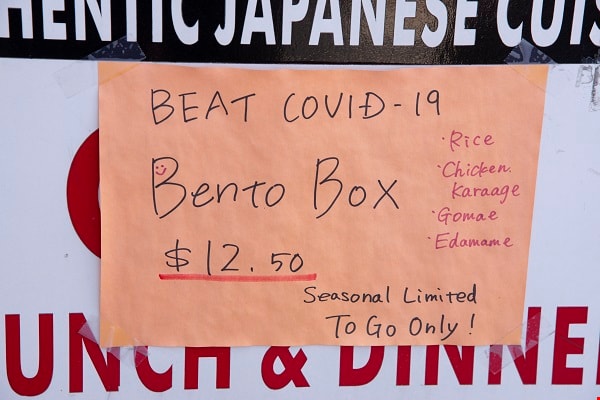
Covid Special
https://search.heritageburnaby.ca/link/archivedescription95127
- Repository
- City of Burnaby Archives
- Date
- April 10, 2020
- Collection/Fonds
- Burnaby Photographic Society fonds
- Description Level
- Item
- Physical Description
- 1 photograph (tiff)
- Scope and Content
- Photograph of a handwritten sign at Kazu Sushi restaurant advertising its bento box special along with the message "Beat COVID-19". The sign is taped to the restaurant's sandwich board.
- Repository
- City of Burnaby Archives
- Date
- April 10, 2020
- Collection/Fonds
- Burnaby Photographic Society fonds
- Physical Description
- 1 photograph (tiff)
- Description Level
- Item
- Record No.
- 623-045
- Access Restriction
- No restrictions
- Reproduction Restriction
- Reproduce for fair dealing purposes only
- Accession Number
- 2020-10
- Scope and Content
- Photograph of a handwritten sign at Kazu Sushi restaurant advertising its bento box special along with the message "Beat COVID-19". The sign is taped to the restaurant's sandwich board.
- Media Type
- Photograph
- Photographer
- Jerome, Ron
- Notes
- Transcribed title
- Geographic Access
- Hastings Street
- Street Address
- 4332 Hastings Street
- Historic Neighbourhood
- Vancouver Heights (Historic Neighbourhood)
- Planning Study Area
- Willingdon Heights Area
Images

Joey Restaurant
https://search.heritageburnaby.ca/link/archivedescription95118
- Repository
- City of Burnaby Archives
- Date
- April 1, 2020
- Collection/Fonds
- Burnaby Photographic Society fonds
- Description Level
- Item
- Physical Description
- 1 photograph (tiff)
- Scope and Content
- Photograph of a sign perched on a decorative tree trunk in the foyer of Joey Burnaby. The sign contains information for patrons on food delivery and pickup.
- Repository
- City of Burnaby Archives
- Date
- April 1, 2020
- Collection/Fonds
- Burnaby Photographic Society fonds
- Physical Description
- 1 photograph (tiff)
- Description Level
- Item
- Record No.
- 623-036
- Access Restriction
- No restrictions
- Reproduction Restriction
- No restrictions
- Accession Number
- 2020-10
- Scope and Content
- Photograph of a sign perched on a decorative tree trunk in the foyer of Joey Burnaby. The sign contains information for patrons on food delivery and pickup.
- Media Type
- Photograph
- Photographer
- Cheung, Ray
- Notes
- Transcribed title
- Photographer's caption: "Most restaurants were only open for take-away"
- Geographic Access
- Rosser Avenue
- Street Address
- 1901 Rosser Avenue
- Planning Study Area
- Willingdon Heights Area
Images


Martello Group sign at 6615 Telford Avenue
https://search.heritageburnaby.ca/link/archivedescription98675
- Repository
- City of Burnaby Archives
- Date
- 2022
- Collection/Fonds
- Disappearing Burnaby collection
- Description Level
- Item
- Physical Description
- 1 photograph (jpeg) : col.
- Scope and Content
- Photograph of a sign, which reads "Professionally Managed by Martello," on the lawn of an apartment building located at 6615 Telford Avenue. The building was constructed in 1964. Other residential towers, a construction crane, and cars parked along Telford Avenue are visible in the background.
- Repository
- City of Burnaby Archives
- Date
- 2022
- Collection/Fonds
- Disappearing Burnaby collection
- Physical Description
- 1 photograph (jpeg) : col.
- Description Level
- Item
- Record No.
- 634-022
- Access Restriction
- No restrictions
- Reproduction Restriction
- No restrictions
- Accession Number
- 2022-14
- Scope and Content
- Photograph of a sign, which reads "Professionally Managed by Martello," on the lawn of an apartment building located at 6615 Telford Avenue. The building was constructed in 1964. Other residential towers, a construction crane, and cars parked along Telford Avenue are visible in the background.
- Subjects
- Buildings - Residential
- Buildings - Residential - Apartments
- Advertising Medium - Signs and Signboards
- Media Type
- Photograph
- Photographer
- Cheung, Nakita
- Notes
- Title taken from the associated blog post
- Associated blog post: https://disappearingburnaby.wordpress.com/2022/06/09/martello-group/
- Geographic Access
- Telford Avenue
- Street Address
- 6615 Telford Avenue
- Historic Neighbourhood
- Central Park (Historic Neighbourhood)
- Planning Study Area
- Maywood Area
Images
