Narrow Results By

Barnet Wagon Road
https://search.heritageburnaby.ca/link/archivedescription38307
- Repository
- City of Burnaby Archives
- Date
- June 1903 (date of original), copied ca. 1990
- Collection/Fonds
- Burnaby Historical Society fonds
- Description Level
- Item
- Physical Description
- 1 photograph : b&w ; 10 x 15 cm print
- Scope and Content
- Photograph of the Barnet Wagon Road looking east, near Barnet and Hastings.
- Repository
- City of Burnaby Archives
- Date
- June 1903 (date of original), copied ca. 1990
- Collection/Fonds
- Burnaby Historical Society fonds
- Subseries
- Photographs subseries
- Physical Description
- 1 photograph : b&w ; 10 x 15 cm print
- Description Level
- Item
- Record No.
- 403-002
- Access Restriction
- No restrictions
- Reproduction Restriction
- No known restrictions
- Accession Number
- BHS2007-04
- Scope and Content
- Photograph of the Barnet Wagon Road looking east, near Barnet and Hastings.
- Subjects
- Land Clearing
- Geographic Features - Roads
- Media Type
- Photograph
- Notes
- Title based on contents of photograph
- Geographic Access
- Barnet Road
- Hastings Street
- Historic Neighbourhood
- Lochdale (Historic Neighbourhood)
- Planning Study Area
- Westridge Area
Images


Boundary Road Lumber Mill
https://search.heritageburnaby.ca/link/archivedescription38262
- Repository
- City of Burnaby Archives
- Date
- 1908
- Collection/Fonds
- Burnaby Historical Society fonds
- Description Level
- Item
- Physical Description
- 1 photograph : sepia ; 9 x 12 cm on 12.5 x 15 cm backing
- Scope and Content
- Photograph of an unidentified man standing in the forefront with a jersey cow to the right, while a row of cabins and cleared tress can be seen in the background. A caption written above the photograph reads: "Boundary Road Lumber Mill owned by E.W. Nicholson." Underneath the photograph is writte…
- Repository
- City of Burnaby Archives
- Date
- 1908
- Collection/Fonds
- Burnaby Historical Society fonds
- Subseries
- Margaret McCallum subseries
- Physical Description
- 1 photograph : sepia ; 9 x 12 cm on 12.5 x 15 cm backing
- Description Level
- Item
- Record No.
- 375-024
- Access Restriction
- No restrictions
- Reproduction Restriction
- No known restrictions
- Accession Number
- BHS1986-42
- Scope and Content
- Photograph of an unidentified man standing in the forefront with a jersey cow to the right, while a row of cabins and cleared tress can be seen in the background. A caption written above the photograph reads: "Boundary Road Lumber Mill owned by E.W. Nicholson." Underneath the photograph is written: "The first Jersey cow on the farm." On the back of the photograph it is noted that the buildings in the background were workmen's buildings.
- Media Type
- Photograph
- Notes
- Title based on caption
- Geographic Access
- Boundary Road
- Still Creek
- Street Address
- 2550 Boundary Road
- Historic Neighbourhood
- Broadview (Historic Neighbourhood)
- Planning Study Area
- West Central Valley Area
Images


Edward W. Nicholson and Team of Horses Inside Tree Stump
https://search.heritageburnaby.ca/link/archivedescription38266
- Repository
- City of Burnaby Archives
- Date
- 1909
- Collection/Fonds
- Burnaby Historical Society fonds
- Description Level
- Item
- Physical Description
- 1 photograph : sepia ; 11 x 16.5 cm on 17.8 x 22.5 cm backing
- Scope and Content
- Photograph of Edward Nicholson standing with a team of horses inside the hollowed stump of a tree. Five other men and a dog are seated on planks on top of the stump and another man and two women are sitting to the left on the exposed roots of the tree. The man on seated to the right is identified …
- Repository
- City of Burnaby Archives
- Date
- 1909
- Collection/Fonds
- Burnaby Historical Society fonds
- Subseries
- Margaret McCallum subseries
- Physical Description
- 1 photograph : sepia ; 11 x 16.5 cm on 17.8 x 22.5 cm backing
- Description Level
- Item
- Record No.
- 375-028
- Access Restriction
- No restrictions
- Reproduction Restriction
- No known restrictions
- Accession Number
- BHS1986-42
- Scope and Content
- Photograph of Edward Nicholson standing with a team of horses inside the hollowed stump of a tree. Five other men and a dog are seated on planks on top of the stump and another man and two women are sitting to the left on the exposed roots of the tree. The man on seated to the right is identified as Duncan MacInnes.
- Subjects
- Transportation - Horses
- Plants - Trees
- Media Type
- Photograph
- Notes
- Title based on caption
- A note on the back of the photograph reads: "E.W. Nicholson first resident of Broadview District of Burnaby - 1900 May 23rd. Picture taken 1909. Edward W. Nicholson, with team of horses inside stump (Cedar). Stump 36 feet in diameter. Duncan MacInnes sitting extreme right. Horses were turned around inside stump."
- Geographic Access
- Boundary Road
- Street Address
- 2550 Boundary Road
- Historic Neighbourhood
- Broadview (Historic Neighbourhood)
- Planning Study Area
- West Central Valley Area
Images

![Lumber Camp and Mill, [between 1906 and 1908] thumbnail](/media/hpo/_Data/_Archives_Images/_Unrestricted/371/375-029.jpg?width=280)
Lumber Camp and Mill
https://search.heritageburnaby.ca/link/archivedescription38267
- Repository
- City of Burnaby Archives
- Date
- [between 1906 and 1908]
- Collection/Fonds
- Burnaby Historical Society fonds
- Description Level
- Item
- Physical Description
- 1 photograph : sepia ; 11.8 x 17 cm on 17.7 x 22.7 cm backing
- Scope and Content
- Photograph of the Nicholson lumber camp and mill in the Broadview area of Burnaby. Approximately 12 men and women can be seen standing in front of the cabins and piles of planks (all are unidentified).
- Repository
- City of Burnaby Archives
- Date
- [between 1906 and 1908]
- Collection/Fonds
- Burnaby Historical Society fonds
- Subseries
- Margaret McCallum subseries
- Physical Description
- 1 photograph : sepia ; 11.8 x 17 cm on 17.7 x 22.7 cm backing
- Description Level
- Item
- Record No.
- 375-029
- Access Restriction
- No restrictions
- Reproduction Restriction
- No known restrictions
- Accession Number
- BHS1986-42
- Scope and Content
- Photograph of the Nicholson lumber camp and mill in the Broadview area of Burnaby. Approximately 12 men and women can be seen standing in front of the cabins and piles of planks (all are unidentified).
- Subjects
- Buildings - Residential - Cabins
- Industries - Forestry
- Occupations - Lumberjacks
- Industries - Logging/lumber
- Media Type
- Photograph
- Notes
- Title based on caption
- A note on the back of the photograph reads: "Lumber camp and mill at Boundary Road and Great Northern Railway 1906-1908 (before railway existed)."
- Geographic Access
- Boundary Road
- Street Address
- 2550 Boundary Road
- Historic Neighbourhood
- Broadview (Historic Neighbourhood)
- Planning Study Area
- West Central Valley Area
Images
![Lumber Camp and Mill, [between 1906 and 1908] thumbnail](/media/hpo/_Data/_Archives_Images/_Unrestricted/371/375-029.jpg)
![Survey and Subdivision plans in New Westminster District Group 1 – Burnaby
, [1908] thumbnail](/media/hpo/_Data/_BVM_Cartographic_Material/1977/1977_0093_0004a_001.jpg?width=280)
Survey and Subdivision plans in New Westminster District Group 1 – Burnaby
https://search.heritageburnaby.ca/link/museumdescription6973
- Repository
- Burnaby Village Museum
- Date
- [1908]
- Collection/Fonds
- Burnaby Village Museum Map collection
- Description Level
- File
- Physical Description
- 10 plans : blueprint ink on paper mounted on 2 sides of cardboard ; 76 cm x 102 cm
- Scope and Content
- Item consists of a large board of four New Westminster District Gp 1 - subdivision plans mounted on one side and six New Westminster District Gp 1 - subdivision plans mounted on the other side. Side A: 1. Blueprint "Plan / of - ReSubdivision / of / Lots 1-18 inclusive / Blocks 20 and 21 / in Sub…
- Repository
- Burnaby Village Museum
- Collection/Fonds
- Burnaby Village Museum Map collection
- Description Level
- File
- Physical Description
- 10 plans : blueprint ink on paper mounted on 2 sides of cardboard ; 76 cm x 102 cm
- Material Details
- Scales [between 1:792 and 1:4752]
- Index number on edge of board reads: "4"
- Scope and Content
- Item consists of a large board of four New Westminster District Gp 1 - subdivision plans mounted on one side and six New Westminster District Gp 1 - subdivision plans mounted on the other side. Side A: 1. Blueprint "Plan / of - ReSubdivision / of / Lots 1-18 inclusive / Blocks 20 and 21 / in Subdivision / of / Lot 53 -Gr.1 / New Westminster District" / "Subdivision Lot Numbers - Shown in Red". Plan is bordered by First Street / Jorgenson's Line / Fourth Avenue and Second Street with Fifith Avenue running through the centre. There is an index in the upper right corner of the plan. Planned is signed by "Peter Byrne" and "William R. Phillips" and dated July 28, 1908. (Geographic location: Burnaby) 2. Blueprint "Plan / of Subdivision / of / Lot 159 / and a Portion of Lot 158 / Group One / New Westminster District". Plan is bordered by Lots 96 and 97; South Wilson Street; North Arm Road and Lot 160 / Power House Road (Lot 155 A). B.C.E.R. Gilley Station is identified in the upper right corner of the plan. (Geographic location: Burnaby) 3. Blueprint plan identified as "Subdvs 10, L 88 and Lot 25, G. 1" Plan identifies Cumberland Street running from top to the bottom and a Ravine running alongside with the Jensen house, stable and barn. (Geographic location: Burnaby) 4. Blueprint Plan of "Lot 153. G. 1 /New Westminster District". Plan identifies the "New Westminster & Vancouver Tramway" and the "New Westminster and Vancouver Road" running through the plan of Lot 53. (Geographic location: Burnaby) Side B: 1. Blueprint plan of "Profile on Proposed North Rd. Diversion". 2. Blueprint plan (no title) showing wood lots north of Burnaby Lake and Brunette River and west of North Road. Various lots are identified as "Heavily Timbered" (Lot 57); "Splendid Fir and Cedar / Heavy Fir etc. / Fine Cedar" (Lots 143, 148); "Rough Light Timber," (Lot 56); "Some Fir and Cedar" (Lot 40). (Geographic location: Burnaby) 3. Blueprint "Plan / of Subdivision / of a Portion / of Lot 87, Gr.1 / New Westminster District". Plan is bordered by Burnaby Lake at the top and Hastings Road / Lot 86 at the bottom and Lot 90 to the east. "Albert J. Hill B.C.LotS." Annotation in ink reads: " J.A. Brownlee, B.C.L.S. / Subdivision / Map 1494 / Bd. 248". Plan is signed by "Peter Byrne, Reeve" (Geographic location: Burnaby) 4. Blueprint plan of Subdivisions along either side of Douglas Road including Lots 117; 119; 74; 80; 79 and 77. (Geographic location: Burnaby) 5. Blueprint "Plan / of / Subdivision of / Lot 27 / in Subdivision / of / Lot 30 / Group One / New Westminster District" Plan is bordered by Lot 26, Lot 28 and Hastings Rd. Lot 27 runs north of Edmonds Street. , "Albert J. Hill, B.C.LotS." (Geographic location: Burnaby) 6. Blueprint plan identified as a "Cultivated Orchard" including the names "W. Grace" and "G. Mead" located north of the North Arm Fraser River and west of "Twentieth Street_ City Boundary". Handwritten annotation in coloured pencil reads: "Portion of Lot 172" (Geographic location: Burnaby)
- Subjects
- Geographic Features - Forests
- Geographic Access
- Cumberland Street
- North Road
- Hastings Street
- Douglas Road
- Accession Code
- HV977.93.4
- Access Restriction
- No restrictions
- Reproduction Restriction
- No known restrictions
- Date
- [1908]
- Media Type
- Cartographic Material
- Historic Neighbourhood
- Burnaby Lake (Historic Neighbourhood)
- Fraser Arm (Historic Neighbourhood)
- Planning Study Area
- Douglas-Gilpin Area
- Burnaby Lake Area
- Scan Resolution
- 300
- Scale
- 72
- Notes
- Title based on contents of file
- Scale is measured in chains. (One chain equals 792 inches)
- The term "Lot" can also refer to a "District Lot”-
Images
![Survey and Subdivision plans in New Westminster District Group 1 – Burnaby
, [1908] thumbnail](/media/hpo/_Data/_BVM_Cartographic_Material/1977/1977_0093_0004a_001.jpg)

![Survey and Subdivision plans in New Westminster District Group 1 – Burnaby, [1905-1917] thumbnail](/media/hpo/_Data/_BVM_Cartographic_Material/1977/1977_0093_0022a_001.jpg?width=280)
Survey and Subdivision plans in New Westminster District Group 1 – Burnaby
https://search.heritageburnaby.ca/link/museumdescription6991
- Repository
- Burnaby Village Museum
- Date
- [1905-1917]
- Collection/Fonds
- Burnaby Village Museum Map collection
- Description Level
- File
- Physical Description
- 12 plans : 6 black ink on paper + 2 black & col. ink on paper + 4 graphite on paper
- Scope and Content
- Item consists of a large board of six New Westminster District subdivision plans mounted on one side and six New Westminster District subdivision plans mounted on the other side. Side A: 1. Plan drawn in graphite with markings in black ink "Surveyed for Mr. W. Wilson / Paterson Stat. B.C.E.R." . …
- Repository
- Burnaby Village Museum
- Collection/Fonds
- Burnaby Village Museum Map collection
- Description Level
- File
- Physical Description
- 12 plans : 6 black ink on paper + 2 black & col. ink on paper + 4 graphite on paper
- Material Details
- Scales [between 1:360 and 1:3168]
- Index number on edge of board reads: "22"
- Scope and Content
- Item consists of a large board of six New Westminster District subdivision plans mounted on one side and six New Westminster District subdivision plans mounted on the other side. Side A: 1. Plan drawn in graphite with markings in black ink "Surveyed for Mr. W. Wilson / Paterson Stat. B.C.E.R." . Plan includes subdivision of lots situated between B.C.E. Railway and Vancouver Road (Kingsway). (Geographic location: Burnaby) 2. Subdivision plan (no title) drawn in black ink with annotations in graphite. Plan covers District Lots 2, 4 and 6, west of North Road. Plan is stamped: "Albert J. Hill, Civil Engineer / and / Provincial Land Surveyor, / New Westminster, / B.C. (Geographic location: Burnaby) 3. Plan of "Portion of Municipality" with intials "RB" [sic] (handwritten in blue crayon). Plan covers the area north east of the City of New Westminster including District Lots 11, 13, 14, 12, 1 and 2. Plan is stamped: "Albert J. Hill, Civil Engineer / and / Provincial Land Surveyor, / New Westminster, / B.C. (Geographic location: Burnaby) 4."Plan / of Subdivision of / N.W.1/4 Lot 175 / Group 1 New West. Dist. / B.C. / Scale 4 chs = 1 in. " Plan is stamped: "Albert J. Hill, Civil Engineer / and / Provincial Land Surveyor, / New Westminster, / B.C. and initialed : "RB" [sic] (in blue pencil crayon) (Geographic location: Burnaby) 5. "Subdivision / of a Portion of / Lot 15 Group 1 / New Westminster Dist. / Scale 4 chs = 1 in". Plan provides numbered sudivisions - Lots 1 to 15 of District Lot 15 in red ink. (Geographic location: Burnaby) 6. Plan of "Central Park & / Vicinity" Plan includes subdivisions of District Lot 153 east of Central Park District Lot 151 and subdivision of District Lot 36 and 49 west of Boundary Road (Vancouver). Plan is stamped: "Albert J. Hill, Civil Engineer / and / Provincial Land Surveyor, / New Westminster, / B.C. and initialed : "RB" [sic] (in blue pencil crayon). (Geographic location: Burnaby) Side B: 1. Subdivision plan (no title) drawn in black ink. Plan identifies lots between Vancouver Road (Yale Road is crossed out and replaced with Vancouver Road) and B.C.E. Railway. "Scale 2 chs = 1 in" (Geographic location: Burnaby) 2. Plan of "Subdivision Lot 1 / Lot 69 Gr. 1 / Scale 30' = 1 " " Plan identifies Boundary Road, Still Creek and a Road Allowance between District Lot 118 and District Lot 69. Plan was "Surveyed for Burnaby Mun. Council / March 11th 1908 / G.K.B." (Geographic location: Burnaby) 3. Plan drawn in black ink (no title) showing a subdivision in Lot 25 with names "Newcomb", "Debeck" and "Armstrong" along with roads identified as Third Street, Cumberland Street, Armstrong Street and Cariboo [sic] Street and including Lots 27, 11 and 13.Plan is stamped: "Albert J. Hill, Civil Engineer / and / Provincial Land Surveyor, / New Westminster, / B.C. and initialed : "RB" [sic] (in blue pencil crayon). (Geographic location: Burnaby) 4. Handrawn subdivision plan in graphite titled: "Lot 13, Gr.1" with intials "RB" [sic] (handwritten in blue crayon). Plan is bordered by Armstrong Street (Lot 11, G.1), Cumberland St. (Lot 25, G.1) and Tenth Avenue (City Boundary). The plan is singed by "Albert J. Hill / P.L.S." and one of the subdivided lots is identified with the name: "W. Karrymann". (Geographic location: Burnaby) 5. Handrawn sketch in graphite titled: "Lot 88, Gr.1" with intials "RB" [sic] (handwritten in blue crayon). Plan appears to be a draft of a subdivision plan of a portion of District Lot 88 along Cumberland Road. The plan is signed: "16/7/17 _W.F. Draper [sic] / B.C.L.S." (Geographic location: Burnaby) 6. "Plan / of Subdivision / of Blocks 61, 62 and 2 / Lot 30 / Group 1 / N.W. Dist. / Scale 1ch = 1 in". Plan is intialed by: "PB" with a note: "Also see board 2 / for duplicate" (handwritten in blue crayon). (Geographic location: Burnaby)
- Creator
- Hill, Albert James
- Geographic Access
- Boundary Road
- Kingsway
- Cumberland Street
- Accession Code
- HV977.93.22
- Access Restriction
- No restrictions
- Reproduction Restriction
- No known restrictions
- Date
- [1905-1917]
- Media Type
- Cartographic Material
- Historic Neighbourhood
- Central Park (Historic Neighbourhood)
- Scan Resolution
- 300
- Scale
- 100
- Notes
- Title based on contents of file
- Scale is measured in chains and feet. (One chain equals 792 inches)
- The term "Lot" can also refer to a "District Lot”
- Some plans are stamped: "Albert J. Hill, Civil Engineer / and / Provincial Land Surveyor, / New Westminster, / B.C." and intialed: "RB" [sic]
Images
![Survey and Subdivision plans in New Westminster District Group 1 – Burnaby, [1905-1917] thumbnail](/media/hpo/_Data/_BVM_Cartographic_Material/1977/1977_0093_0022a_001.jpg)


Topping a tree near Central Park
https://search.heritageburnaby.ca/link/archivedescription37280
- Repository
- City of Burnaby Archives
- Date
- 1904
- Collection/Fonds
- Burnaby Historical Society fonds
- Description Level
- Item
- Physical Description
- 1 photograph : sepia toned ; 21 x 26.5 cm
- Scope and Content
- Photograph of a man "topping" a large tree in the area near Central Park and Boundary Road.
- Repository
- City of Burnaby Archives
- Date
- 1904
- Collection/Fonds
- Burnaby Historical Society fonds
- Subseries
- Norah Code subseries
- Physical Description
- 1 photograph : sepia toned ; 21 x 26.5 cm
- Description Level
- Item
- Record No.
- 345-001
- Access Restriction
- No restrictions
- Reproduction Restriction
- No known restrictions
- Accession Number
- BHS1997-05
- Scope and Content
- Photograph of a man "topping" a large tree in the area near Central Park and Boundary Road.
- Media Type
- Photograph
- Photographer
- Code, Norah
- Notes
- Title based on contents of photograph
- Photographs in this collection were taken and compiled by Norah Code, former editor of the "Burnaby Courier" newspaper during the course of her work for the newspaper. A note with the file indicates that the man in the tree may be Ms. Code's father but his name is not provided.
- Geographic Access
- Boundary Road
- Central Park
- Historic Neighbourhood
- Central Park (Historic Neighbourhood)
- Planning Study Area
- Maywood Area
Images

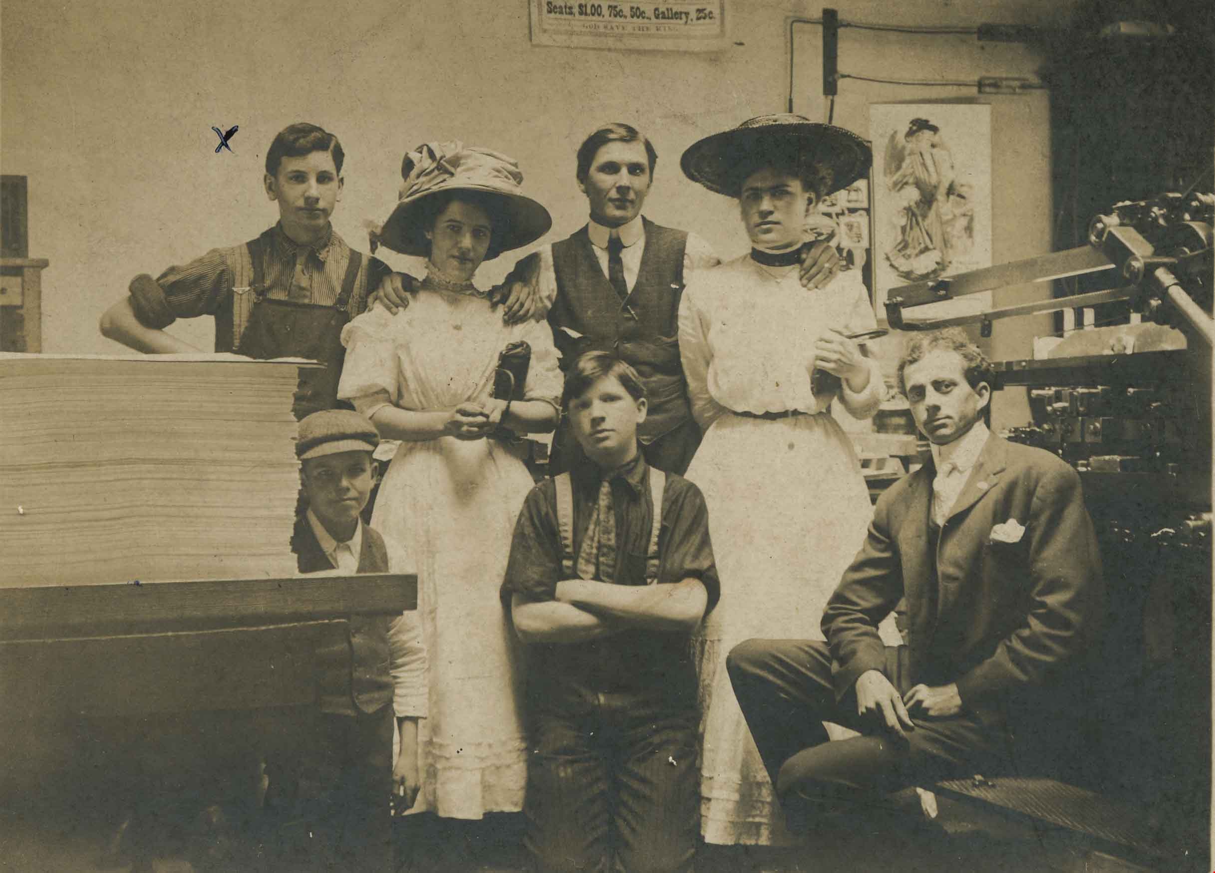
Working as a Press Feeder
https://search.heritageburnaby.ca/link/archivedescription36152
- Repository
- City of Burnaby Archives
- Date
- 1908
- Collection/Fonds
- Burnaby Historical Society fonds
- Description Level
- Item
- Physical Description
- 1 photograph : b&w ; 7.5 x 10 cm, mounted on board 13.5 x 16 cm
- Scope and Content
- Photograph of Mr Murdoch McMurray (far left) working as a Press Feeder, and his co-workers, at a firm believed to be on or near Hastings. The young women standing with Murdoch worked in the "Bindery".
- Repository
- City of Burnaby Archives
- Date
- 1908
- Collection/Fonds
- Burnaby Historical Society fonds
- Physical Description
- 1 photograph : b&w ; 7.5 x 10 cm, mounted on board 13.5 x 16 cm
- Description Level
- Item
- Record No.
- 229-001
- Access Restriction
- No restrictions
- Reproduction Restriction
- No known restrictions
- Accession Number
- BHS1989-22
- Scope and Content
- Photograph of Mr Murdoch McMurray (far left) working as a Press Feeder, and his co-workers, at a firm believed to be on or near Hastings. The young women standing with Murdoch worked in the "Bindery".
- Names
- McMurray, Murdoch
- Media Type
- Photograph
- Notes
- Title based on contents of photograph
- Note on verso of photograph reads: "...Mr. McMurray was making 10 dollars a week at the time."
- Geographic Access
- Hastings Street
Images