Narrow Results By
Creator
- Draper, William Nelson 1
- Fleming, Frances "Fanny" Waplington 1
- Galbraith, Eleanor Lois 1
- Garden, Hermon and Burwell 3
- Garden, Hermon & Burwell 1
- Government of British Columbia - Department of Lands and Works 1
- Government of Canada - Department of Mines - Geological Survey Branch 1
- Hill, Albert James 4
- Martin, George Bohun 1
- Stathern, John 1
- Strathern, John 1
![3813 Deer Lake Avenue, Burnaby. B.C., [2002] thumbnail](/media/hpo/_Data/_BVM_Textual_Records/2016/2016_0046_0139_001.jpg?width=280)
3813 Deer Lake Avenue, Burnaby. B.C.
https://search.heritageburnaby.ca/link/museumdescription18980
- Repository
- Burnaby Village Museum
- Date
- [2002]
- Collection/Fonds
- Waplington family fonds
- Description Level
- Item
- Physical Description
- 1 p. of textual records
- Scope and Content
- Item consists of a one page document conveying the history of ownership of house located at 3813 Deer Lake Avenue, Burnaby. Document states that the house was owned by John "Jack" Waplington and Sarah Alice Cogswell (Nickerson) Waplington between 1925 and 1946; Ray and Frances Louise Fleming betwe…
- Repository
- Burnaby Village Museum
- Collection/Fonds
- Waplington family fonds
- Description Level
- Item
- Physical Description
- 1 p. of textual records
- Scope and Content
- Item consists of a one page document conveying the history of ownership of house located at 3813 Deer Lake Avenue, Burnaby. Document states that the house was owned by John "Jack" Waplington and Sarah Alice Cogswell (Nickerson) Waplington between 1925 and 1946; Ray and Frances Louise Fleming between 1947 and 1958 and owned by Burnaby Muncipality from 1959 until 1970 to make way for the building of Heritage Village (Burnaby Village Museum).
- Accession Code
- BV016.46.139
- Access Restriction
- No restrictions
- Reproduction Restriction
- No known restrictions
- Date
- [2002]
- Media Type
- Textual Record
- Scan Resolution
- 600
- Scan Date
- 2023-01-06
- Notes
- Transcribed title
- Document is part of Photograph album BV016.46.52
Images
![3813 Deer Lake Avenue, Burnaby. B.C., [2002] thumbnail](/media/hpo/_Data/_BVM_Textual_Records/2016/2016_0046_0139_001.jpg)

Alice Hart photograph album
https://search.heritageburnaby.ca/link/museumdescription14366
- Repository
- Burnaby Village Museum
- Date
- 1893-1923 (date of original), copied 1976
- Collection/Fonds
- Florence Hart Godwin fonds
- Description Level
- File
- Physical Description
- 1 album (31 photographs: b&w negatives ; 35 mm)
- Scope and Content
- File consists of a photographic reproduction of a twenty nine page photograph album that was created by Alice Hart. Inscription inside of front cover reads "To dearest Alice from father 30th March 1906". The album is filled with photographs of the Hart family along with friends and relations. The p…
- Repository
- Burnaby Village Museum
- Collection/Fonds
- Florence Hart Godwin fonds
- Description Level
- File
- Physical Description
- 1 album (31 photographs: b&w negatives ; 35 mm)
- Scope and Content
- File consists of a photographic reproduction of a twenty nine page photograph album that was created by Alice Hart. Inscription inside of front cover reads "To dearest Alice from father 30th March 1906". The album is filled with photographs of the Hart family along with friends and relations. The photographs range between 1893 and 1923 and document time spent at residences in New Westminster, Deer Lake and Kerrisdale along with family vacations at Mayne Island, Stanely Park and Pitt Lake.
- Accession Code
- HV976.169.1
- Access Restriction
- No restrictions
- Reproduction Restriction
- No known restrictions
- Date
- 1893-1923 (date of original), copied 1976
- Media Type
- Photograph
- Textual Record
- Scan Date
- 10/27/2020
- Notes
- Title based on contents of photograph album
- Inscription on first page of album reads: "To dearest Alice / from father / 30th March, 1906”.
- 31 b&w copy prints accompanying
- Album pages are described at item level
Images

Documents
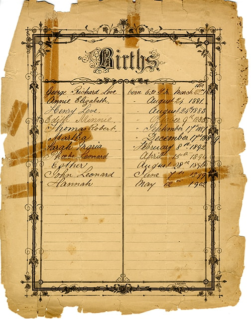
Births of Jesse and Martha Love
https://search.heritageburnaby.ca/link/museumdescription16926
- Repository
- Burnaby Village Museum
- Date
- 1879-1902
- Collection/Fonds
- Love family fonds
- Description Level
- Item
- Physical Description
- 1 p. : 24 x 30 cm
- Scope and Content
- Item consists of a births record page listing the children of Jesse and Martha Love. The page is presumed to be removed from a bible, potentially the Love family bible (BV992.26.1). The information on the obverse reads "Births / George Richard Love born 6:30 P.M March 22nd 1880 / Annie Elizabeth " …
- Repository
- Burnaby Village Museum
- Collection/Fonds
- Love family fonds
- Description Level
- Item
- Physical Description
- 1 p. : 24 x 30 cm
- Scope and Content
- Item consists of a births record page listing the children of Jesse and Martha Love. The page is presumed to be removed from a bible, potentially the Love family bible (BV992.26.1). The information on the obverse reads "Births / George Richard Love born 6:30 P.M March 22nd 1880 / Annie Elizabeth " August 24 1881 / Henry Love " August 24th 1883 / Edith Minnie " October 9th 1885 / Thomas Robert " September 17th 1887 / Martha "December 17th 1889 / Sarah Maria " February 8th 1892 / Phoebe Leonard April 15th 1894 / Esther August 28th 1896 / John Leonard June 7th 1899 / Hannah May 12th 1902". The reverse reads "Deaths" with no further notations.
- Accession Code
- BV992.26.30
- Access Restriction
- No restrictions
- Reproduction Restriction
- No known restrictions
- Date
- 1879-1902
- Media Type
- Textual Record
- Scan Resolution
- 600
- Scan Date
- 2022-06-10
- Notes
- Title based on the content of the page
Images
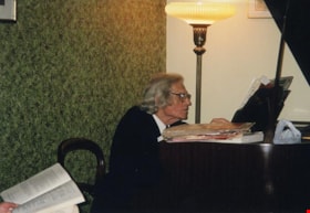
Burnaby Clef Society papers
https://search.heritageburnaby.ca/link/archivedescription57837
- Repository
- City of Burnaby Archives
- Date
- 1998-2000
- Collection/Fonds
- Burnaby Historical Society fonds
- Description Level
- File
- Physical Description
- 2 files of textual records and 33 photographs : col. ; 10 cm x 15 cm
- Scope and Content
- File contains papers pertaining to the Burnaby Clef Society, including financial records, contracts, minutes, thank you cards, and other correspondence. File also contains photographs of award recipients, musicians, and concert and Christmas party attendees.
- Repository
- City of Burnaby Archives
- Date
- 1998-2000
- Collection/Fonds
- Burnaby Historical Society fonds
- Subseries
- Burnaby Clef Society subseries
- Physical Description
- 2 files of textual records and 33 photographs : col. ; 10 cm x 15 cm
- Description Level
- File
- Record No.
- MSS020-030
- Reproduction Restriction
- May be restricted by third party rights
- Accession Number
- BHS2007-04
- Scope and Content
- File contains papers pertaining to the Burnaby Clef Society, including financial records, contracts, minutes, thank you cards, and other correspondence. File also contains photographs of award recipients, musicians, and concert and Christmas party attendees.
- Media Type
- Textual Record
- Photograph
- Notes
- Title based on contents of file
- Photographs 142-003-27:142-003-33 originally housed in an enveloped labelled "Proway Printers"
Images

Burnaby Clef Society papers
https://search.heritageburnaby.ca/link/archivedescription57838
- Repository
- City of Burnaby Archives
- Date
- 1998-2000
- Collection/Fonds
- Burnaby Historical Society fonds
- Description Level
- File
- Physical Description
- 1 file of textual records and 4 photographs : col. ; 10 cm x 15 cm
- Scope and Content
- File contains papers pertaining to the Burnaby Clef Society, including financial records, contracts, scholarship recipient records and other correspondence. File also includes photographs of concert attendees and musicians.
- Repository
- City of Burnaby Archives
- Date
- 1998-2000
- Collection/Fonds
- Burnaby Historical Society fonds
- Subseries
- Burnaby Clef Society subseries
- Physical Description
- 1 file of textual records and 4 photographs : col. ; 10 cm x 15 cm
- Description Level
- File
- Record No.
- MSS020-031
- Reproduction Restriction
- May be restricted by third party rights
- Accession Number
- BHS2007-04
- Scope and Content
- File contains papers pertaining to the Burnaby Clef Society, including financial records, contracts, scholarship recipient records and other correspondence. File also includes photographs of concert attendees and musicians.
- Media Type
- Textual Record
- Photograph
- Notes
- Title based on contents of file
Images

Burnaby Clef Society press information
https://search.heritageburnaby.ca/link/archivedescription57840
- Repository
- City of Burnaby Archives
- Date
- 1992-2000
- Collection/Fonds
- Burnaby Historical Society fonds
- Description Level
- File
- Physical Description
- 1 file of textual records and 2 photographs : col. ; 10 cm x 15 cm
- Scope and Content
- File contains two folders with papers pertaining to press information pertaining to the Burnaby Clef Society, including contact information, photocopied newspaper articles and correspondence.
- Repository
- City of Burnaby Archives
- Date
- 1992-2000
- Collection/Fonds
- Burnaby Historical Society fonds
- Subseries
- Burnaby Clef Society subseries
- Physical Description
- 1 file of textual records and 2 photographs : col. ; 10 cm x 15 cm
- Description Level
- File
- Record No.
- MSS020-033
- Accession Number
- BHS2007-04
- Scope and Content
- File contains two folders with papers pertaining to press information pertaining to the Burnaby Clef Society, including contact information, photocopied newspaper articles and correspondence.
- Media Type
- Textual Record
- Photograph
- Notes
- Title based on contents of file
Images

![Douglas Road School, [2001] thumbnail](/media/hpo/_Data/_BVM_Textual_Records/2016/2016_0046_0156_001.jpg?width=280)
Douglas Road School
https://search.heritageburnaby.ca/link/museumdescription18995
- Repository
- Burnaby Village Museum
- Date
- [2001]
- Collection/Fonds
- Waplington family fonds
- Description Level
- Item
- Physical Description
- 1 p.
- Scope and Content
- Item consists of a handwritten note on paper in the shaped of an apple. Note is titled "Douglas Road School" and includes location of Douglas Road School and the names of the Waplington children (Frances, John and Grace Waplington) and Fleming children (John Reyland, Edith and Sara Fleming) and the…
- Repository
- Burnaby Village Museum
- Collection/Fonds
- Waplington family fonds
- Description Level
- Item
- Physical Description
- 1 p.
- Scope and Content
- Item consists of a handwritten note on paper in the shaped of an apple. Note is titled "Douglas Road School" and includes location of Douglas Road School and the names of the Waplington children (Frances, John and Grace Waplington) and Fleming children (John Reyland, Edith and Sara Fleming) and the dates that they attended the school.
- Accession Code
- BV016.46.156
- Access Restriction
- No restrictions
- Reproduction Restriction
- No known restrictions
- Date
- [2001]
- Media Type
- Textual Record
- Scan Resolution
- 600
- Scan Date
- 2023-01-06
- Notes
- Title based on contents of item
- Document is part of Photograph album BV016.46.52
Images
![Douglas Road School, [2001] thumbnail](/media/hpo/_Data/_BVM_Textual_Records/2016/2016_0046_0156_001.jpg)
Eleanor Galbraith Girl Guide scrapbook
https://search.heritageburnaby.ca/link/museumdescription4585
- Repository
- Burnaby Village Museum
- Date
- 1962-2005 (date of original), copied 2016
- Collection/Fonds
- Burnaby Girl Guides fonds
- Description Level
- File
- Physical Description
- 1 scrapbook (1 digital file : (pdf) + 32 photographs : col. (tiffs) + 32 photographs) + 1 folder of textual records
- Scope and Content
- File consists of images of a scrapbook that was created by Eleanor Galbraith during her involvement with the Burnaby Heights Division of Girl Guides. Records that were retained include: 123 "Long Service Certificate(s)" awarded to Eleanor Galbraith (Feb. 10, 1965; March 4, 1986); a letter in recog…
- Repository
- Burnaby Village Museum
- Collection/Fonds
- Burnaby Girl Guides fonds
- Description Level
- File
- Physical Description
- 1 scrapbook (1 digital file : (pdf) + 32 photographs : col. (tiffs) + 32 photographs) + 1 folder of textual records
- Scope and Content
- File consists of images of a scrapbook that was created by Eleanor Galbraith during her involvement with the Burnaby Heights Division of Girl Guides. Records that were retained include: 123 "Long Service Certificate(s)" awarded to Eleanor Galbraith (Feb. 10, 1965; March 4, 1986); a letter in recognition and receipt of an award for "50 Years of Service" (April 5, 2005); a "9th Annual Meeting" programme hosted by Burnaby Imperial Division; a warrant card for Miss Eleanor Galbraith of 12th Burnaby Company; a Girl Guides of Canada warrant for Miss Eleanor Galbraith to act as "District Commissioner" (September 28, 1965); an Appointment Warrant card for Miss Eleanor Galbraith for authorization to act as "Deputy Division / Commissioner of Burnaby Heights / B.C. Council" and letter of congratulations; a thank you letter to Eleanor Galbraith from Guiders of Vancouver Heights District for faithful years of leadership; two warrants from Girl Guides of Canada to Miss Eleanor Galbraith to act as Deputy Division Commissioner - Burnaby Heights Division (October 24, 1967 and January 29, 1969) ; an appointment card to Miss Eleanor Galbraith to act as the Commissoner of Burnaby Heights Division and three clipped obituaries for Kathleen Hebron (nee Billingham), Eleanor Holvick (nee Bruce) and Mr.s Jim (Doris) Fowler.
- Creator
- Galbraith, Eleanor Lois
- Edition
- `
- Accession Code
- BV015.35.157
- Access Restriction
- No restrictions
- Reproduction Restriction
- May be restricted by third party rights
- Date
- 1962-2005 (date of original), copied 2016
- Media Type
- Textual Record
- Photograph
- Notes
- Title based on contents of file
- Digital images were created of the scrapbook prior to selective retention of original records
- Selected textual records were retained under BV015.35.157 (some of these records are subject to FIPPA)
Images

Documents

Florence Hart Godwin photograph album
https://search.heritageburnaby.ca/link/museumdescription3049
- Repository
- Burnaby Village Museum
- Date
- 1893-1923 (date of original), copied 1976
- Collection/Fonds
- Florence Hart Godwin fonds
- Description Level
- File
- Physical Description
- 1 album (29 photographs: b&w negatives ; 35 mm)
- Scope and Content
- File consists of a photographic reproduction of a twenty nine page photograph album that was created by Florence Hart Godwin. The first page of the album reads "Florence, with Grandma's and Auntie Felicia's best love, Xmas 1910" and the other pages contain photographs. The album was given to Flore…
- Repository
- Burnaby Village Museum
- Collection/Fonds
- Florence Hart Godwin fonds
- Description Level
- File
- Physical Description
- 1 album (29 photographs: b&w negatives ; 35 mm)
- Scope and Content
- File consists of a photographic reproduction of a twenty nine page photograph album that was created by Florence Hart Godwin. The first page of the album reads "Florence, with Grandma's and Auntie Felicia's best love, Xmas 1910" and the other pages contain photographs. The album was given to Florence Hart for Christmas in 1910, by her grandmother Jane Chapman (nee Isbell) and her Aunt Felicia Chapman. Album contains photographs of the Alice and Frederick J. Hart and Chapman families, including childhood photographs of the five Hart children, Kingsley, Florence, Fredricka, Edwyna and Jack; the Hart family at their home in New Westminster and at "Avalon" their summer residence and home on Deer Lake.
- Names
- Godwin, Florence Hart
- Accession Code
- HV976.168.1
- Access Restriction
- No restrictions
- Reproduction Restriction
- No known restrictions
- Date
- 1893-1923 (date of original), copied 1976
- Media Type
- Photograph
- Textual Record
- Scan Resolution
- 600
- Scan Date
- 2023-07-24
- Notes
- Title based on contents of photograph album
- 29 b&w copy prints accompanying
- Item level descriptions available per album page
Images

Documents
![In and Out of a Cedar Shake Shack, [ca. 2000] thumbnail](/media/hpo/_Data/_BVM_Textual_Records/2016/2016_0046_0051_002.jpg?width=280)
In and Out of a Cedar Shake Shack
https://search.heritageburnaby.ca/link/museumdescription4617
- Repository
- Burnaby Village Museum
- Date
- [ca. 2000]
- Collection/Fonds
- Waplington family fonds
- Description Level
- Item
- Physical Description
- 1 manuscript : 200 pages
- Scope and Content
- Item consists of a copy of an unpublished manuscript titled "In and Out of a Cedar Shake Shack The life of a little girl from World War I to Canada's Diamond Jubilee" written by Frances L. Fleming (nee Waplington).
- Repository
- Burnaby Village Museum
- Collection/Fonds
- Waplington family fonds
- Description Level
- Item
- Physical Description
- 1 manuscript : 200 pages
- Scope and Content
- Item consists of a copy of an unpublished manuscript titled "In and Out of a Cedar Shake Shack The life of a little girl from World War I to Canada's Diamond Jubilee" written by Frances L. Fleming (nee Waplington).
- Other Title Information
- Title continues:... The life of a little girl from World War I to Canada's Diamond Jubilee
- Accession Code
- BV016.46.51
- Access Restriction
- Restricted access
- Reproduction Restriction
- Reproductions subject to FIPPA
- Date
- [ca. 2000]
- Media Type
- Textual Record
- Notes
- Transcribed title
- Experts from this manuscript (pages 113-126) “Christmas Time” and “The Fire Brigade”. have been made available as a pdf. Contact Burnaby Village Museum to view the Manuscript in it's entirety.
Images
![In and Out of a Cedar Shake Shack, [ca. 2000] thumbnail](/media/hpo/_Data/_BVM_Textual_Records/2016/2016_0046_0051_002.jpg)
Documents

Love family correspondence
https://search.heritageburnaby.ca/link/museumdescription10087
- Repository
- Burnaby Village Museum
- Date
- 1880-1911
- Collection/Fonds
- Love family fonds
- Description Level
- File
- Physical Description
- 1 folder of textual records
- Scope and Content
- File consists of a series of personal letters from family members in England to Jesse and Martha Love., including; Sept 22, 1880- to Jesse and Martha Love from Jesse's mother Elizabeth Love; June 7th, 1880- to Jesse from his mother Elizabeth Love; June 9th, 1880- Letter to Jesse Love from his moth…
- Repository
- Burnaby Village Museum
- Collection/Fonds
- Love family fonds
- Description Level
- File
- Physical Description
- 1 folder of textual records
- Scope and Content
- File consists of a series of personal letters from family members in England to Jesse and Martha Love., including; Sept 22, 1880- to Jesse and Martha Love from Jesse's mother Elizabeth Love; June 7th, 1880- to Jesse from his mother Elizabeth Love; June 9th, 1880- Letter to Jesse Love from his mother Elizabeth Love; April 26, 1880 - to Jesse and Martha Love from Jesse's mother Elizabeth Love; May 21, 1881 -To Jesse Love from one of his sisters regarding his mother's death; Jan 18, 1892 - Swindon - to Jesse from his sister, informing him of his father's death; 8th Jan 1906 - to Jesse from his sister,Torie Love; 28 Oct 1910 - to Martha Love from Jesse's sister Torie Love; 27th, (month?) 1910 - to Jesse Love and one of his sisters from Jesse's sister Torie; 14th July 1911 - Letter to Jesse and Martha Love from Jesse's sister Torie; an envelope - addressed to "Mr. Jesse Love / East Burnaby, New Westminster / B.C." postmarked "Jan __ 05 / SWINDON STATION" (does not appear to relate to any of the dates of the letters) and a small evelope addressed to : "Mrs Love / Burnaby".
- History
- See extensive history of Love Family and Love farmhouse located at Burnaby Village Museum.
- Accession Code
- BV012.31.19
- Access Restriction
- No restrictions
- Reproduction Restriction
- No known restrictions
- Date
- 1880-1911
- Media Type
- Textual Record
- Scan Resolution
- 300
- Scan Date
- Feb-02-2012
- Scale
- 96
- Notes
- Title based on content of file
Images


Map of South Western Part of British Columbia
https://search.heritageburnaby.ca/link/museumdescription8688
- Repository
- Burnaby Village Museum
- Date
- 1897
- Collection/Fonds
- Burnaby Village Museum Map collection
- Description Level
- Item
- Physical Description
- 1 map : col. ink on paper ; 68 x 88 cm
- Scope and Content
- Item consists of a "MAP OF THE SOUTH-WESTERN PART OF BRITISH COLUMBIA”. Map identifies geographic land districts of New Westminster District; Coast District; Lillooet District; Yale District, Kamloops Division, Yale Division and districts on Vancouver Island. Map also includes the northern portions…
- Repository
- Burnaby Village Museum
- Collection/Fonds
- Burnaby Village Museum Map collection
- Description Level
- Item
- Physical Description
- 1 map : col. ink on paper ; 68 x 88 cm
- Material Details
- Scale [1:633600]
- Scope and Content
- Item consists of a "MAP OF THE SOUTH-WESTERN PART OF BRITISH COLUMBIA”. Map identifies geographic land districts of New Westminster District; Coast District; Lillooet District; Yale District, Kamloops Division, Yale Division and districts on Vancouver Island. Map also includes the northern portions of the State of Washington below the 49th parallel.
- Publisher
- The Colonist Litho Victoria B.C.
- Responsibility
- Martin, George Bohun
- Accession Code
- BV993.12.12
- Access Restriction
- No restrictions
- Reproduction Restriction
- No known restrictions
- Date
- 1897
- Media Type
- Cartographic Material
- Scan Resolution
- 600
- Scan Date
- 2023-08-17
- Notes
- Transcribed title
- Scale equals 1 inch to 10 miles
- "Compiled and drawn by direction of the Honouable G.B. Martin, Chief Commissioner of Lands and Works, Victoria, B.C."
- Signed by Surveyor General "Tom Kains"
Zoomable Images

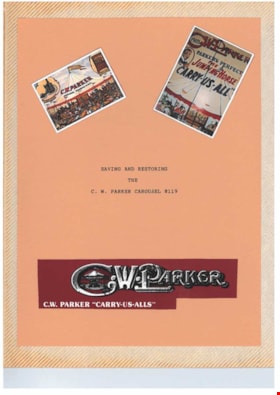
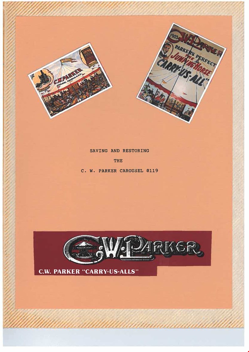
Parker Carousel Volume I
https://search.heritageburnaby.ca/link/museumdescription4555
- Repository
- Burnaby Village Museum
- Date
- 1989-2004
- Collection/Fonds
- Keith Jamieson fonds
- Description Level
- Item
- Physical Description
- 1 album (4 photographs + textual records + ephemera)
- Scope and Content
- Item consists of one of three scrapbooks titled, "Parker Carousel Volume 1- Saving and Restoring the C.W. Parker Carousel no. 119". The scrapbook contains newspaper clippings, correspondence, newsletters and original photographs documenting "The Friends of the Carousel" fundraising endeavours as we…
- Repository
- Burnaby Village Museum
- Collection/Fonds
- Keith Jamieson fonds
- Description Level
- Item
- Physical Description
- 1 album (4 photographs + textual records + ephemera)
- Scope and Content
- Item consists of one of three scrapbooks titled, "Parker Carousel Volume 1- Saving and Restoring the C.W. Parker Carousel no. 119". The scrapbook contains newspaper clippings, correspondence, newsletters and original photographs documenting "The Friends of the Carousel" fundraising endeavours as well as the restoration and installation of the C.W. Parker carouselno. 119. The carousel was rescued from the PNE and re-installed at the Burnaby Village Museum.
- Subjects
- Recreational Devices - Carousels
- Names
- Lower Mainland Association of the Friends of the Vancouver Carousel
- Jamieson, Keith
- Jamieson, Pat
- Pacific National Exhibition (PNE)
- C.W. Parker no. 119 Carousel
- Accession Code
- BV015.41.1
- Date
- 1989-2004
- Media Type
- Photograph
- Textual Record
- Arrangement
- Scrapbooks were arranged by Keith and Pat Jamieson before donation.
- Notes
- Title based on contents of item
Images
Documents

Part of the New Westminster District shewing the Proposed New Municipality of Burnaby
https://search.heritageburnaby.ca/link/museumdescription17544
- Repository
- Burnaby Village Museum
- Date
- 1891 (date of original)
- Collection/Fonds
- Burnaby Village Museum Map collection
- Description Level
- Item
- Physical Description
- 1 map : blueline print with col. ; 59 x 96 cm
- Scope and Content
- Item consists of a map titled "Part of the New Westminster District shewing the Proposed New Municipality of Burnaby". The map shows boundaries of a proposed new municipality of Burnaby including all land outside of the "old" City of Vancouver between Burrard Inlet and the Fraser River and west of …
- Repository
- Burnaby Village Museum
- Collection/Fonds
- Burnaby Village Museum Map collection
- Description Level
- Item
- Physical Description
- 1 map : blueline print with col. ; 59 x 96 cm
- Material Details
- Scale approx. [1:31,680]
- Scope and Content
- Item consists of a map titled "Part of the New Westminster District shewing the Proposed New Municipality of Burnaby". The map shows boundaries of a proposed new municipality of Burnaby including all land outside of the "old" City of Vancouver between Burrard Inlet and the Fraser River and west of North Road. Map also shows the boundaries of the District Lots. Signed by Garden, Hermon and Burwell Provincial Land Surveyors, Vancouver, June 5, 1891. Blueline print is hand-coloured highlighting Burnaby.
- Creator
- Garden, Hermon and Burwell
- Accession Code
- BV994.29.1
- Access Restriction
- No restrictions
- Reproduction Restriction
- No known restrictions
- Date
- 1891 (date of original)
- Media Type
- Cartographic Material
- Scan Resolution
- 300
- Scan Date
- 2022-05-10
- Notes
- Transcribed title
Images

![Plot of Royal Engineers' Surveys - North Road, [1890] thumbnail](/media/hpo/_Data/_BVM_Cartographic_Material/2003/2003_0083_0034_002%20Web.jpg?width=280)
Plot of Royal Engineers' Surveys - North Road
https://search.heritageburnaby.ca/link/museumdescription11155
- Repository
- Burnaby Village Museum
- Date
- [1890]
- Collection/Fonds
- Ronald G. Scobbie collection
- Description Level
- Item
- Physical Description
- 1 survey plan : blueprint on paper ; 61 x 45 cm
- Scope and Content
- Survey plan of "Plot of Royal Engineers' Surveys," "North Road."
- Repository
- Burnaby Village Museum
- Collection/Fonds
- Ronald G. Scobbie collection
- Description Level
- Item
- Physical Description
- 1 survey plan : blueprint on paper ; 61 x 45 cm
- Material Details
- Scale 10 chains = 1 inch
- Scope and Content
- Survey plan of "Plot of Royal Engineers' Surveys," "North Road."
- Geographic Access
- North Road
- Accession Code
- BV003.83.34
- Access Restriction
- No restrictions
- Reproduction Restriction
- No known restrictions
- Date
- [1890]
- Media Type
- Cartographic Material
- Scan Resolution
- 440
- Scan Date
- December 2020
- Scale
- 100
- Notes
- Title based on contents of plan
- Handwritten notes on verso read: "Envelope 369", and mathematical calculat- ions
Images
![Plot of Royal Engineers' Surveys - North Road, [1890] thumbnail](/media/hpo/_Data/_BVM_Cartographic_Material/2003/2003_0083_0034_002%20Web.jpg)
![Subdivision plans in New Westminster District Group 1 – Burnaby
, [1882-1910] thumbnail](/media/hpo/_Data/_BVM_Cartographic_Material/1977/1977_0093_0013a_001.jpg?width=280)
Subdivision plans in New Westminster District Group 1 – Burnaby
https://search.heritageburnaby.ca/link/museumdescription6982
- Repository
- Burnaby Village Museum
- Date
- [1882-1910]
- Collection/Fonds
- Burnaby Village Museum Map collection
- Description Level
- File
- Physical Description
- 4 plans : blueprint on paper mounted on 2 sides of cardboard 76 x 102 cm
- Scope and Content
- Item consists of a large board of two New Westminster District Gp 1 - subdivision plans mounted on one side and two New Westminster District Gp 1 - subdivision plans mounted on the other side. Side A: 1. Blueprint "Plan / of the / Subdivision / of / Lot 98 / G.1, N.W.D. / Scale 4 chs = 1 in. / …
- Repository
- Burnaby Village Museum
- Collection/Fonds
- Burnaby Village Museum Map collection
- Description Level
- File
- Physical Description
- 4 plans : blueprint on paper mounted on 2 sides of cardboard 76 x 102 cm
- Material Details
- Scales [between 1:1584 and 1:3168]
- Index number on edge of board reads: "13"
- Scope and Content
- Item consists of a large board of two New Westminster District Gp 1 - subdivision plans mounted on one side and two New Westminster District Gp 1 - subdivision plans mounted on the other side. Side A: 1. Blueprint "Plan / of the / Subdivision / of / Lot 98 / G.1, N.W.D. / Scale 4 chs = 1 in. / Map No 573" (Geographic location: Burnaby) 2. Blueprint "Plan / of Subdivision of / Lot 157 / Gr.1, New. West. Dist. / Scale 3 chs = 1 in. / Map No. 612". (Geographic location: Burnaby) Side B: 1. Blueprint "Plan / of Subdivision / of a Portion of / Lot 90 / Group One / New Westminster Dist. / Scale 2 chs = 1 in. / Map No. 555". Plan is signed by "Jno Strathern [sic]_P.L.S."n (Geographic location: Burnaby) 2. Blueprint "Subdivision of Lot 31, Group 1. / New Westminster District / As Amended by Order of Court / 1st Sept. 1882 and Numbered 847 / Scale 4 chs = 1in. / Map No 80" (Geographic location: Burnaby)
- Creator
- Stathern, John
- Accession Code
- HV977.93.13
- Access Restriction
- No restrictions
- Reproduction Restriction
- No known restrictions
- Date
- [1882-1910]
- Media Type
- Cartographic Material
- Historic Neighbourhood
- Alta Vista (Historic Neighbourhood)
- Planning Study Area
- Richmond Park Area
- Lakeview-Mayfield Area
- Scan Resolution
- 300
- Scale
- 72
- Notes
- Title based on contents of file
- Scale is measured in chains. (One chain equals 792 inches)
- The term "Lot" can also refer to a "District Lot”
Images
![Subdivision plans in New Westminster District Group 1 – Burnaby
, [1882-1910] thumbnail](/media/hpo/_Data/_BVM_Cartographic_Material/1977/1977_0093_0013a_001.jpg)

![Subdivision plans in New Westminster District Group 1 – Burnaby
, [1890-1910] thumbnail](/media/hpo/_Data/_BVM_Cartographic_Material/1977/1977_0093_0014a_001.jpg?width=280)
Subdivision plans in New Westminster District Group 1 – Burnaby
https://search.heritageburnaby.ca/link/museumdescription6983
- Repository
- Burnaby Village Museum
- Date
- [1890-1910]
- Collection/Fonds
- Burnaby Village Museum Map collection
- Description Level
- File
- Physical Description
- 4 plans : blueprint ink on paper mounted on 2 sides of cardboard 76 x 102 cm
- Scope and Content
- Item consists of a large board of two New Westminster District Gp 1 - subdivision plans mounted on one side and two New Westminster District Gp 1 - subdivision plans mounted on the other side. Side A: 1. Blueprint "Plan of / Subdivision of Lot No. 69 / Group One / New Westminster District / Pro…
- Repository
- Burnaby Village Museum
- Collection/Fonds
- Burnaby Village Museum Map collection
- Description Level
- File
- Physical Description
- 4 plans : blueprint ink on paper mounted on 2 sides of cardboard 76 x 102 cm
- Material Details
- Scales [between 1:1584 and 1:3168]
- Index number on edge of board reads: "14"
- Scope and Content
- Item consists of a large board of two New Westminster District Gp 1 - subdivision plans mounted on one side and two New Westminster District Gp 1 - subdivision plans mounted on the other side. Side A: 1. Blueprint "Plan of / Subdivision of Lot No. 69 / Group One / New Westminster District / Property of Ernest Buse, Esq. / Scale 3 chs = 1 in. / Map No 290". Plan is signed by "Garden, Hermon and Burwell, Dom. Land Surveyor" (Geographic location: Burnaby) 2. Blueprint "Plan / of Subdivision / of Lots 1-19, 36-53 and 69-75 inclusive / in the Subdivision / of / Lot 30 / Group One / New Westminster District / Scale 2 chs = 1 in. Map No 631". Plan is signed by "Jno [sic] Strathern [sic] P.L.S." Names and Lot numbers are handwritten in red pencil in sections along Douglas Road and read: "20 - F / 21 - Fitherstruhaul [sic] / 22 - J.S. Craig / 23 - McGill & Dill / 24 / 25 / 26 / 27 / 28 - School / 29 - School / 30 - D. McDownall / 31 - W.J. Troloow [sic] / 32 - N.C. Nelson / 33 - _[sic] McGill / 34 - T.S.[sic] Craig / 35" (Geographic location: Burnaby) Side B: 1.Blueprint "Plan / of Subdivision / of Centre Portion / of Lot 28 / Group One / New Westminster District / Scale 200' = 1" / Map No 627". Plan is signed by "Jno Strathern / P.L.S." (Geographic location: Burnaby) 2. Blueprint "Plan / of Subdivision / of N.1/2 Lot 100 and S.1/2 Lot 101, / Group One / New Westminster District, BC / Scale 4 chs = 1 in." (Geographic location: Burnaby)
- Names
- Strathern, John
- Accession Code
- HV977.93.14
- Access Restriction
- No restrictions
- Reproduction Restriction
- No known restrictions
- Date
- [1890-1910]
- Media Type
- Cartographic Material
- Historic Neighbourhood
- Broadview (Historic Neighbourhood)
- East Burnaby (Historic Neighbourhood)
- Planning Study Area
- Cascade-Schou Area
- West Central Valley Area
- Second Street Area
- Lake City Area
- Scan Resolution
- 300
- Scale
- 72
- Notes
- Title based on contents of file
- Scale is measured in chains and feet. (One chain equals 792 inches)
- The term "Lot" can also refer to a "District Lot”
Images
![Subdivision plans in New Westminster District Group 1 – Burnaby
, [1890-1910] thumbnail](/media/hpo/_Data/_BVM_Cartographic_Material/1977/1977_0093_0014a_001.jpg)

![Subdivision plans in New Westminster District Group 1 – Burnaby
, [1891-1910] thumbnail](/media/hpo/_Data/_BVM_Cartographic_Material/1977/1977_0093_0015a_001.jpg?width=280)
Subdivision plans in New Westminster District Group 1 – Burnaby
https://search.heritageburnaby.ca/link/museumdescription6984
- Repository
- Burnaby Village Museum
- Date
- [1891-1910]
- Collection/Fonds
- Burnaby Village Museum Map collection
- Description Level
- File
- Physical Description
- 4 plans : blueprint ink on paper mounted on 2 sides of cardboard 76 x 102 cm
- Scope and Content
- Item consists of a large board of two New Westminster District Gp 1 - subdivision plans mounted on one side and two New Westminster District Gp 1 - subdivision plans mounted on the other side. Side A: 1. Blueprint "Plan / of Subdivision / of / Lot 29 / Group One / New Westminster District / Scal…
- Repository
- Burnaby Village Museum
- Collection/Fonds
- Burnaby Village Museum Map collection
- Description Level
- File
- Physical Description
- 4 plans : blueprint ink on paper mounted on 2 sides of cardboard 76 x 102 cm
- Material Details
- Scales [between 1:600 and 1:7920]
- Index number on edge of board reads: "15"
- Scope and Content
- Item consists of a large board of two New Westminster District Gp 1 - subdivision plans mounted on one side and two New Westminster District Gp 1 - subdivision plans mounted on the other side. Side A: 1. Blueprint "Plan / of Subdivision / of / Lot 29 / Group One / New Westminster District / Scale 4 chs = 1 in. / Map No 564, Depostd '91". "Reichenbach", dep. Aug. 1891. (Geographic location: Burnaby) 2. Blueprint "Plan / of Subdivision / of / Lot 93 / Group One / New Westminster District / Scale 4 chs = 1 in. / Map No 284". (Geographic location: Burnaby) Side B: 1. Blueprint "Plan / of Subdivision / of a Portion / of / [Lot A of ] Lot 29 / Group One / New Westminster District / Scale 50 ' = 1"" Plan is bordered by Douglas Road to the east, False Creek Trail to the south and Lot 30 to the north. (Geographic location: Burnaby) 2. Blueprint "Plan / of Central Park / and Vicinity / Scale 10 chs = 1 in." (Geographic location: Burnaby)
- Accession Code
- HV977.93.15
- Access Restriction
- No restrictions
- Reproduction Restriction
- No known restrictions
- Date
- [1891-1910]
- Media Type
- Cartographic Material
- Historic Neighbourhood
- Edmonds (Historic Neighbourhood)
- Planning Study Area
- Edmonds Area
- Scan Resolution
- 300
- Scale
- 72
- Notes
- Title based on contents of file
- Scale is measured in chains and feet. (One chain equals 792 inches)
- The term "Lot" can also refer to a "District Lot”
Images
![Subdivision plans in New Westminster District Group 1 – Burnaby
, [1891-1910] thumbnail](/media/hpo/_Data/_BVM_Cartographic_Material/1977/1977_0093_0015a_001.jpg)

![Subdivision plans in New Westminster District Group 1 – Burnaby
, [1893-1910] thumbnail](/media/hpo/_Data/_BVM_Cartographic_Material/1977/1977_0093_0016a_001.jpg?width=280)
Subdivision plans in New Westminster District Group 1 – Burnaby
https://search.heritageburnaby.ca/link/museumdescription6985
- Repository
- Burnaby Village Museum
- Date
- [1893-1910]
- Collection/Fonds
- Burnaby Village Museum Map collection
- Description Level
- File
- Physical Description
- 4 plans : blueprint ink on paper mounted on 2 sides of cardboard 76 x 102 cm
- Scope and Content
- Item consists of a large board of two New Westminster District Gp 1 - subdivision plans mounted on one side and two New Westminster District Gp 1 - subdivision plans mounted on the other side. Side A: 1. Blueprint "Plan / of Subdivision / of / Lot 6 / Group One / New Westminster District / Scale…
- Repository
- Burnaby Village Museum
- Collection/Fonds
- Burnaby Village Museum Map collection
- Description Level
- File
- Physical Description
- 4 plans : blueprint ink on paper mounted on 2 sides of cardboard 76 x 102 cm
- Material Details
- Scales [between 1:1584 and 1:3960]
- Index number on edge of board reads: "16"
- Scope and Content
- Item consists of a large board of two New Westminster District Gp 1 - subdivision plans mounted on one side and two New Westminster District Gp 1 - subdivision plans mounted on the other side. Side A: 1. Blueprint "Plan / of Subdivision / of / Lot 6 / Group One / New Westminster District / Scale 5 chs = 1 in. / Map No 748" (Geographic location: Burnaby) 2. Blueprint "Plan / of Subdivision / of a Portion / of / Lot 29 / Group One / New Westminster Dist. / Scale 2 chs = 1 in. / Map No." Name identified in Block H is "Reichenbach" (Geographic location: Burnaby) Side B: 1. Blueprint "Plan / of Subdivision / of North 1/2 of Lot 80 / Group One / New Westminster District / Scale 3 chs = 1 in. / Map No 719" Plan is signed by: "Garden, Hermon & Burwell P.L.S. / Vancouver Jan. 23rd, 1893" (Geographic location: Burnaby) 2. Blueprint "Plan / of Subdivision / of Lot 79, Gr.1 / New Westminster Dist. / Scale 4 chas = 1 in. / Map No 536" Plan is signed by "Garden Hermon & Burwell / Provincial Land Surveyors". (Geographic location: Burnaby)
- Creator
- Garden, Hermon and Burwell
- Accession Code
- HV977.93.16
- Access Restriction
- No restrictions
- Reproduction Restriction
- No known restrictions
- Date
- [1893-1910]
- Media Type
- Cartographic Material
- Historic Neighbourhood
- Edmonds (Historic Neighbourhood)
- Burnaby Lake (Historic Neighbourhood)
- Planning Study Area
- Douglas-Gilpin Area
- Edmonds Area
- Cameron Area
- Scan Resolution
- 300
- Scale
- 72
- Notes
- Title based on contents of file
- Scale is measured in chains. (One chain equals 792 inches)
- The term "Lot" can also refer to a "District Lot”
Images
![Subdivision plans in New Westminster District Group 1 – Burnaby
, [1893-1910] thumbnail](/media/hpo/_Data/_BVM_Cartographic_Material/1977/1977_0093_0016a_001.jpg)


Subdivision plans in New Westminster District Group 1 – Burnaby, Vancouver and map - Canada Department of Mines
https://search.heritageburnaby.ca/link/museumdescription6994
- Repository
- Burnaby Village Museum
- Date
- 1890-1909
- Collection/Fonds
- Burnaby Village Museum Map collection
- Description Level
- File
- Physical Description
- 1 plan : graphite on paper + 2 plans : black ink on paper + 1 map : col. on paper mounted on 2 sides of cardboard 76 x 102 cm
- Scope and Content
- Item consists of a large board with one New Westminster District subdivision plan mounted on one side and two New Westminster District subdivision plans and one colour map mounted on the other side. Side A: 1. "Plan / of Subdivision of / Blocks 2, 3, 4, 5, 6 / Lot 77 / Group 1 / New Westminster D…
- Repository
- Burnaby Village Museum
- Collection/Fonds
- Burnaby Village Museum Map collection
- Description Level
- File
- Physical Description
- 1 plan : graphite on paper + 2 plans : black ink on paper + 1 map : col. on paper mounted on 2 sides of cardboard 76 x 102 cm
- Material Details
- Scales 1:720 and 1:1200 and 1:.00001578
- Scope and Content
- Item consists of a large board with one New Westminster District subdivision plan mounted on one side and two New Westminster District subdivision plans and one colour map mounted on the other side. Side A: 1. "Plan / of Subdivision of / Blocks 2, 3, 4, 5, 6 / Lot 77 / Group 1 / New Westminster District / BC. / Scale 100 feet = 1 inch", "Deposited 8th day / of April 1890 / Mowileg [sic] / Dist. Regt". Plan is drawn in graphite with annotations: "AB_Parts_lettered_are_lots_in / the_different_subdivisions" / "Owners: / James E. Hall / P.S.Cabilan [sic] by his attorney Joseph Hall / Joseph Hall / Eliza J. Shannon / John Harrison"; "This plan is correct and is prepared under the / provisions of the Land Registry Act" ; signed by: "Gordon Herman & Burwell / Dominion & Provincial Land Surveryors / Vancouver March 19th/90" . Plan is initialed by: "RB" [sic] (in blue pencil crayon) and measures: 99.5 x 65 cm (Geographic location: Burnaby) Side B: 1. Map titled "Canada / Department of Mines / Geological Survey Branch" / "Hon.W Templeton, Minister / A.P. Low, Deputy Minister / R.W. Brock, Acting Director", Vol. XXXI, Plate I / Compiled under the direction of / James White, F.R.G.S. Geographer /Dep. of Interior". Note above map reads: "To illustrate Mr. James Barrowman's report as Delegate at the Excursion - meeting of the Canadian Mining Institute", "The instiitution of Mining Engineers / Transactions 1908 - 1909", "The Mining Institute of Scotland / Transactions 1908-1909". Map identifies minerals and includes a Legend and Scale: 100 miles = 1 inch 2. "Plan / of Subdivision of / Lot 4 / of Subdivision of / Lot 87. Gr. 1 / New Westminster District / Scale 60' = 1in." Plan is initialed by: "RB" [sic] along with a note "also Board / 48" (in blue pencil crayon) (Geographic location: Burnaby) 3. Plan of "Lot 335 / G. 1" west of Boundary Road and north of River Road - Vancouver. (Geographic location: Vancouver)
- Publisher
- The Mining Institute of Scotland
- Geographic Access
- Vancouver
- Accession Code
- HV977.93.25
- Access Restriction
- No restrictions
- Reproduction Restriction
- No known restrictions
- Date
- 1890-1909
- Media Type
- Cartographic Material
- Scan Resolution
- 300
- Scale
- 72
- Notes
- Title based on contents of file
- Scale is measured in feet and miles.
- The term "Lot" often refers to "District Lot"
Images

