Narrow Results By
Decade
- 2020s 84
- 2010s 213
- 2000s 392
- 1990s
- 1980s 550
- 1970s 708
- 1960s
- 1950s 588
- 1940s 546
- 1930s 754
- 1920s 704
- 1910s 639
- 1900s 304
- 1890s 166
- 1880s
- 1870s 14
- 1860s 15
- 1850s 7
- 1840s 3
- 1830s
- 1820s 2
- 1810s 2
- 1800s 2
- 1790s 1
- 1780s 1
- 1770s 1
- 1760s 1
- 1750s 1
- 1740s 1
- 1730s 1
- 1720s 1
- 1710s 1
- 1700s 1
- 1690s 1
- 1680s 1
- 1670s 1
- 1660s 1
- 1650s 1
- 1640s 1
- 1630s 1
- 1620s 1
- 1610s 1
- 1600s 1
Appointments to Greater Vancouver Regional Labour Relations Bureau and the Greater Vancouver Transit Authority (GVTA)
https://search.heritageburnaby.ca/link/councilreport5608
- Repository
- City of Burnaby Archives
- Report ID
- 61549
- Meeting Date
- 22-Jun-1998
- Format
- Council - Mayor/Councillor/Staff Report
- Collection/Fonds
- City Council and Office of the City Clerk fonds
- Repository
- City of Burnaby Archives
- Report ID
- 61549
- Meeting Date
- 22-Jun-1998
- Format
- Council - Mayor/Councillor/Staff Report
- Collection/Fonds
- City Council and Office of the City Clerk fonds
Documents
Financing through Greater Vancouver Sewerage and Drainage District and Greater Vancouver Water Board
https://search.heritageburnaby.ca/link/councilreport36381
- Repository
- City of Burnaby Archives
- Report ID
- 32456
- Meeting Date
- 21-Jun-1965
- Format
- Council - Manager's Report
- Manager's Report No.
- 46
- Item No.
- 13
- Collection/Fonds
- City Council and Office of the City Clerk fonds
- Repository
- City of Burnaby Archives
- Report ID
- 32456
- Meeting Date
- 21-Jun-1965
- Format
- Council - Manager's Report
- Manager's Report No.
- 46
- Item No.
- 13
- Collection/Fonds
- City Council and Office of the City Clerk fonds
Documents
Greater Vancouver Key Facts - A Statistical Profile of Greater Vancouver - 1991
https://search.heritageburnaby.ca/link/archivedescription32042
- Repository
- City of Burnaby Archives
- Date
- 1991
- Collection/Fonds
- Planning Department fonds
- Description Level
- File
- Physical Description
- Textual record
- Repository
- City of Burnaby Archives
- Date
- 1991
- Collection/Fonds
- Planning Department fonds
- Physical Description
- Textual record
- Description Level
- File
- Record No.
- 35056
- Accession Number
- 2006-16
- Media Type
- Textual Record
Greater Vancouver Key Facts - A Statistical Profile of Greater Vancouver - 1996
https://search.heritageburnaby.ca/link/archivedescription32041
- Repository
- City of Burnaby Archives
- Date
- 1996
- Collection/Fonds
- Planning Department fonds
- Description Level
- File
- Physical Description
- Textual record
- Repository
- City of Burnaby Archives
- Date
- 1996
- Collection/Fonds
- Planning Department fonds
- Physical Description
- Textual record
- Description Level
- File
- Record No.
- 35055
- Accession Number
- 2006-16
- Media Type
- Textual Record
Greater Vancouver Key Facts - A Statistical Profile of Greater Vancouver - 1997
https://search.heritageburnaby.ca/link/archivedescription32040
- Repository
- City of Burnaby Archives
- Date
- 1997
- Collection/Fonds
- Planning Department fonds
- Description Level
- File
- Physical Description
- Textual record
- Repository
- City of Burnaby Archives
- Date
- 1997
- Collection/Fonds
- Planning Department fonds
- Physical Description
- Textual record
- Description Level
- File
- Record No.
- 35054
- Accession Number
- 2006-16
- Media Type
- Textual Record
Letter from the Corporation of the District of North Vancouver re: Bylaws # 6281 and 6582 (Amendments to the Seymour Official Community Plan and the Deep Cove Official Plan, District of North Vancouver)
https://search.heritageburnaby.ca/link/councilreport11763
- Repository
- City of Burnaby Archives
- Report ID
- 8099
- Meeting Date
- 4-Sep-1990
- Format
- Council - Manager's Report
- Manager's Report No.
- 53
- Item No.
- 6
- Collection/Fonds
- City Council and Office of the City Clerk fonds
- Repository
- City of Burnaby Archives
- Report ID
- 8099
- Meeting Date
- 4-Sep-1990
- Format
- Council - Manager's Report
- Manager's Report No.
- 53
- Item No.
- 6
- Collection/Fonds
- City Council and Office of the City Clerk fonds
Documents
Letter from the Greater Vancouver Regional District regarding group homes in Greater Vancouver
https://search.heritageburnaby.ca/link/councilreport9169
- Repository
- City of Burnaby Archives
- Report ID
- 6163
- Meeting Date
- 29-Nov-1993
- Format
- Council - Manager's Report
- Manager's Report No.
- 70
- Item No.
- 20
- Collection/Fonds
- City Council and Office of the City Clerk fonds
- Repository
- City of Burnaby Archives
- Report ID
- 6163
- Meeting Date
- 29-Nov-1993
- Format
- Council - Manager's Report
- Manager's Report No.
- 70
- Item No.
- 20
- Collection/Fonds
- City Council and Office of the City Clerk fonds
Documents
Vancouver discovers Vancouver : an excerpt from the rough logs of Second Lieutenant Peter John Puget
https://search.heritageburnaby.ca/link/museumlibrary1146
- Repository
- Burnaby Village Museum
- Author
- Puget, Peter John
- Publication Date
- 1990
- Call Number
- 971.1133 PUG
- Repository
- Burnaby Village Museum
- Collection
- Reference Collection
- Material Type
- Book
- Call Number
- 971.1133 PUG
- Author
- Puget, Peter John
- Contributor
- Lamb, W. K.
- Place of Publication
- Burnaby
- Publisher
- Vancouver Conference on Exploration and Discovery
- Publication Date
- 1990
- Physical Description
- 23 p. : ill. ; 22 cm.
- Library Subject (LOC)
- Burrard Inlet (B.C.)--Discovery and exploration
- Discoveries in geography
- Notes
- "To Commemorate the arrival of Captain George Vancouver on the Pacific Northwest Coast of North America in 1792"
- "Simon Fraser University will host An International and Interdisciplinary Conference on Exploration and Discovery in April 1992"
Burnaby Heights Neighbourhood
https://search.heritageburnaby.ca/link/landmark776
- Repository
- Burnaby Heritage Planning
- Associated Dates
- 1955-2008
- Heritage Value
- Up until the 1970s, this neighbourhood was known as Vancouver Heights. When a new park was created during that decade and named "Burnaby Heights Park," the name was gradually adopted by newcomers to the area. Today, you will hear residents refer to their neighbourhood as Burnaby Heights, Vancouver Heights, or just "The Heights." Throughout the 1960s and 1970s, the commercial district in this neighbourhood continued to grow and a Retail Merchants Association was formed which later became known as the Heights Merchants Association. The neighbourhood still retains a residential neighbourhood characteristic with an increasing number of apartment buildings and multi-family units being built over the past 20 years.
- Historic Neighbourhood
- Vancouver Heights (Historic Neighbourhood)
- Planning Study Area
- Burnaby Heights Area
Images
Burnaby Lake Neighbourhood
https://search.heritageburnaby.ca/link/landmark821
- Repository
- Burnaby Heritage Planning
- Associated Dates
- 1955-2008
- Heritage Value
- In 1966 Burnaby Lake was identified as a key potential regional park in the GVRD ’s Regional Park Plan for the Lower Mainland. The lake was to be developed for nature study, strolling, trail riding, canoeing, sightseeing and picnicking. It was formally recognized as a regional nature park in 1979, at which time the GVRD assumed management of the park through a lease agreement with the City of Burnaby. In 1993 Burnaby Lake was selected by the City of Burnaby to be included in Greater Vancouver ’s Green Zone, and was identified as a key component of the GVRD ’s Park and Outdoor Recreation System (PORS) for the Burrard/Peninsula/Richmond sector, which includes Burnaby, Vancouver, New Westminster, and Richmond.
- Historic Neighbourhood
- Burnaby Lake (Historic Neighbourhood)
- Planning Study Area
- Burnaby Lake Area
Images
Brantford Elementary School
https://search.heritageburnaby.ca/link/landmark809
- Repository
- Burnaby Heritage Planning
- Geographic Access
- Brantford Avenue
- Associated Dates
- 1965
- Heritage Value
- As housing developments extended north from Kingsway, pupil enrolments grew at Windsor and at Morley Schools so Brantford was built equidistant from the two to help ease enrolment problems. Brantford Elementary school opened in 1965 and was similar in structure to other schools built in Burnaby during this period - no basements, no second stories and no high stairways. Classrooms were built in a line and could easily be added to as enrolments increased. Brantford had room additions in 1969.
- Historic Neighbourhood
- Edmonds (Historic Neighbourhood)
- Planning Study Area
- Kingsway-Beresford Area
- Street Address
- 6512 Brantford Avenue
- Street View URL
- Google Maps Street View
Images
Burnaby North High School
https://search.heritageburnaby.ca/link/landmark745
- Repository
- Burnaby Heritage Planning
- Associated Dates
- 1923-1982
- Street View URL
- Google Maps Street View
- Repository
- Burnaby Heritage Planning
- Geographic Access
- Willingdon Avenue
- Associated Dates
- 1923-1982
- Heritage Value
- Burnaby North and Burnaby South were the first high schools built in the City. Before the high school opened, Burnaby students had to travel to Vancouver if they wished to pursue education beyond an elementary level. In 1921, arrangements were made to use the basement of the Presbyterian Church for instruction of local students. By 1922 the Burnaby North High School opened at its first permanent location (4375 Pandora Street - which is now Rosser Elementary). In 1945, the Willingdon Avenue site was built and was used until a new building was constructed in 1961 on Hammarskjold Drive. From 1962, the school was used as Burnaby Heights Junior High school, but it closed in 1982 and the junior high students went to the new Burnaby North on Hammarskjold.
- Historic Neighbourhood
- Capitol Hill (Historic Neighbourhood)
- Planning Study Area
- Capitol Hill Area
- Street Address
- 250 Willingdon Avenue
- Street View URL
- Google Maps Street View
Images
Burnaby South Secondary School and The B.C. Provincial School for the Deaf
https://search.heritageburnaby.ca/link/landmark844
- Repository
- Burnaby Heritage Planning
- Geographic Access
- Rumble Street
- Associated Dates
- 1993
- Heritage Value
- The original Burnaby South High School was replaced in 1993 and the new Burnaby South Secondary School and BC Provincial School for the Deaf was built at this location. This school was built with the latest technology and modern equipment to ensure it was fully accessible and offers integrated academic, social and recreational activities for its students.
- Historic Neighbourhood
- Alta Vista (Historic Neighbourhood)
- Planning Study Area
- Clinton-Glenwood Area
- Street Address
- 5455 Rumble Street
- Street View URL
- Google Maps Street View
Images
Cameron Elementary School
https://search.heritageburnaby.ca/link/landmark833
- Repository
- Burnaby Heritage Planning
- Geographic Access
- Erickson Drive
- Associated Dates
- 1965
- Heritage Value
- The increasing density of housing around the Lougheed Shopping Centre area resulted in a spike in enrolment at Lyndhurst Elementary School. As a result, in 1965, Cameron Road Elementary was built to alleviate overcrowding issues. The school opened with 151 pupils. The school was expanded in 1969 when three classrooms were added and again in 1971 when eights more rooms and a library were built.
- Historic Neighbourhood
- Burquitlam (Historic Neighbourhood)
- Planning Study Area
- Cameron Area
- Street Address
- 9540 Erickson Drive
- Street View URL
- Google Maps Street View
Images
Cariboo Hill Secondary School
https://search.heritageburnaby.ca/link/landmark837
- Repository
- Burnaby Heritage Planning
- Geographic Access
- 16th Avenue
- Associated Dates
- 1961
- Heritage Value
- By 1961, three new elementary schools had been built in the northeast section of Burnaby - Armstrong, Seaforth, and Lyndhurst. With growing enrolment at each, too many students were required to travel a farther distance to attend Edmonds Junior High School. As a result, the Cariboo Hill Secondary School was built in 1961 and opened with 410 students. Its peak enrolment was during the 1974 school year when over 1100 students attended. Additions to the school were made in 1969, 1971 and 1974.
- Historic Neighbourhood
- East Burnaby (Historic Neighbourhood)
- Planning Study Area
- Cariboo-Armstrong Area
- Street Address
- 8580 16th Avenue
- Street View URL
- Google Maps Street View
Images
Chaffey-Burke Elementary School
https://search.heritageburnaby.ca/link/landmark810
- Repository
- Burnaby Heritage Planning
- Geographic Access
- Sardis Street
- Associated Dates
- 1963
- Heritage Value
- Chaffey-Burke Elementary School was built in 1963 and deviated slightly from the typical one-storey buildings that had been the standard for elementary schools in Burnaby since World War Two. At Chaffey-Burke, the restriction of space resulted in a second story level because of the slope. Additions to the building were made in 1964, 1968 and 1969.
- Historic Neighbourhood
- Central Park (Historic Neighbourhood)
- Planning Study Area
- Garden Village Area
- Street Address
- 4404 Sardis Street
- Street View URL
- Google Maps Street View
Images
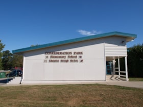
Confederation Park Elementary School
https://search.heritageburnaby.ca/link/landmark786
- Repository
- Burnaby Heritage Planning
- Geographic Access
- Pandora Street
- Associated Dates
- 1965
- Heritage Value
- Confederation Park school was built in 1965 to alleviate increased enrolments in Rosser Avenue and Capitol Hill schools. All elementary schools built in Burnaby in the post-war period share similar features and Confederation Park is no exception. Built low to the ground with no basement, no second stories and no high stairways, the structures could be easily added to as needed as the classrooms were built in a line.
- Historic Neighbourhood
- Capitol Hill (Historic Neighbourhood)
- Planning Study Area
- Capitol Hill Area
- Street Address
- 4715 Pandora Street
- Street View URL
- Google Maps Street View
Images
Maywood Elementary School
https://search.heritageburnaby.ca/link/landmark812
- Repository
- Burnaby Heritage Planning
- Geographic Access
- Imperial Street
- Associated Dates
- 1962
- Heritage Value
- Located between Nelson and Suncrest Schools, Maywood Elementary School was built in 1962 and helped eased the increasing enrolments at these other schools. Like other schools of this period, Maywood was built on one level with no basement and no high stairs. The classrooms were built in a line which could be easily added to as required. Additions to the original structure were completed in 1964, 1966, 1967, 1971, 1972. Fires at the school in 1979 and 1989 caused extensive damage and required partial reconstruction of the building.
- Historic Neighbourhood
- Central Park (Historic Neighbourhood)
- Planning Study Area
- Maywood Area
- Street Address
- 4567 Imperial Street
- Street View URL
- Google Maps Street View
Images
Shell Oil Company
https://search.heritageburnaby.ca/link/landmark675
- Repository
- Burnaby Heritage Planning
- Geographic Access
- Kensington Avenue
- Associated Dates
- ca. 1930-1993
- Heritage Value
- After considering several sites in the Greater Vancouver area, the Shell Oil Company chose 70 acres in North Burnaby with frontage of one third of a mile on Burrard Inlet. Shell proposed to build a four-million dollar plant that would employ up to 2000 - providing some relief in the middle of Burnaby's economic crisis of the Depression years. The site became known as the Shellburn Refinery and was in operation until 1993.
- Historic Neighbourhood
- Lochdale (Historic Neighbourhood)
- Planning Study Area
- Westridge Area
Images
South Slope Elementary School & The B.C. Provincial School for the Deaf
https://search.heritageburnaby.ca/link/landmark843
- Repository
- Burnaby Heritage Planning
- Geographic Access
- Watling Street
- Associated Dates
- 1992
- Heritage Value
- South Slope/B.C. School for the Deaf opened in 1992 and is one of the newer elementary schools in the City. The 2009 School Growth Plan notes that South Slope/BC School for the Deaf replaced the former Jericho Hill School for the Deaf in Vancouver.
- Historic Neighbourhood
- Alta Vista (Historic Neighbourhood)
- Planning Study Area
- Sussex-Nelson Area
- Street Address
- 4446 Watling Street
- Street View URL
- Google Maps Street View


