Narrow Results By
Subject
- Advertising Medium 1
- Agriculture - Farms 2
- Animals - Dogs 1
- Buildings 1
- Buildings - Heritage 1
- Buildings - Public - Detention Facilities 1
- Buildings - Public - Post Offices 1
- Buildings - Residential 1
- Buildings - Residential - Houses 2
- Buildings - Schools 1
- Clothing - Costumes 9
- Clothing - Uniforms 1
Creator
- Albert F. Arnold 1
- Babcock, John Pease, 1855-1936 1
- Bancroft, Rose 1
- Benson, Arthur Christopher, 1862-1925 1
- Binks, James 1
- Bolton, Richard 1
- Burnaby Art Gallery 1
- Burnaby Village Museum 3
- Caldwell, Otis W. (Otis William), 1869-1947 1
- Canada. Commission of Conservation 1
- Canada. Department of Mines 2
- Canada. Department of the Interior 2
Treasurer Report re Government Grant to School Board
https://search.heritageburnaby.ca/link/councilreport74194
- Repository
- City of Burnaby Archives
- Report ID
- 80805
- Meeting Date
- 25-Apr-1916
- Format
- Council - Committee Report
- Collection/Fonds
- City Council and Office of the City Clerk fonds
- Repository
- City of Burnaby Archives
- Report ID
- 80805
- Meeting Date
- 25-Apr-1916
- Format
- Council - Committee Report
- Collection/Fonds
- City Council and Office of the City Clerk fonds
Documents
Westminster Board of Trade requesting the Council to appoint a delegate on the deputation about to wait on the Government re the Fraser River Bridge and the Ladner-Westminster Road projects
https://search.heritageburnaby.ca/link/councilreport79151
- Repository
- City of Burnaby Archives
- Report ID
- 89140
- Meeting Date
- 18-Feb-1901
- Format
- Council - Mayor/Councillor/Staff Report
- Collection/Fonds
- City Council and Office of the City Clerk fonds
- Repository
- City of Burnaby Archives
- Report ID
- 89140
- Meeting Date
- 18-Feb-1901
- Format
- Council - Mayor/Councillor/Staff Report
- Collection/Fonds
- City Council and Office of the City Clerk fonds
Documents
The winning of popular government : a chronicle of the union of 1841, v.27
https://search.heritageburnaby.ca/link/museumlibrary5122
- Repository
- Burnaby Village Museum
- Collection
- Special Collection
- Material Type
- Book
- Accession Code
- BV004.106.14
- Call Number
- 971 CHR v.27
- Place of Publication
- Toronto
- Publisher
- Glasgow, Brook & Company
- Publication Date
- 1916
- Series
- Chronicles of Canada, 27
- Printer
- T. and A. Constable
- Physical Description
- xi, 172 p., [7] leaves of plates : ill. (some col.), ports. ; 19 cm.
- Library Subject (LOC)
- Canada--History
- Notes
- "Edited by George M. Wrong and H.H. Langton"
- "In thirty-two volumes"
- "Part VII The Struggle for Political Freedom"
- Includes bibliographic references and index.
- Author's given names and dates: MacMechan Archibald McKellar, 1862-1933
- Editor's given names and dates: Wrong, George McKinnon, 1860-1948
- Editor's given names and dates: Langton, H.H. (Hugh Hornby), 1862-1953
![British Columbia Parliament buildings, [betweeen 1945 and 1948] thumbnail](/media/hpo/_Data/_BVM_Images/2020/2020_0031_0012_001.jpg?width=280)
British Columbia Parliament buildings
https://search.heritageburnaby.ca/link/museumdescription20291
- Repository
- Burnaby Village Museum
- Date
- [betweeen 1945 and 1948]
- Collection/Fonds
- Joseph H.C. Corsbie fonds
- Description Level
- Item
- Physical Description
- 1 photograph : b&w ; 6.5 x 9 cm
- Scope and Content
- Photograph of British Columbia Parliament buildings, home of the Legislative Assembly of British Columbia in Victoria. A car is parked out on the street in front.
- Repository
- Burnaby Village Museum
- Collection/Fonds
- Joseph H.C. Corsbie fonds
- Description Level
- Item
- Physical Description
- 1 photograph : b&w ; 6.5 x 9 cm
- Scope and Content
- Photograph of British Columbia Parliament buildings, home of the Legislative Assembly of British Columbia in Victoria. A car is parked out on the street in front.
- Geographic Access
- Victoria
- Accession Code
- BV020.31.12
- Access Restriction
- No restrictions
- Reproduction Restriction
- No known restrictions
- Date
- [betweeen 1945 and 1948]
- Media Type
- Photograph
- Scan Resolution
- 600
- Scan Date
- 19-09-2023
- Notes
- Title based on contents of photograph
Images
![British Columbia Parliament buildings, [betweeen 1945 and 1948] thumbnail](/media/hpo/_Data/_BVM_Images/2020/2020_0031_0012_001.jpg)
Interview with Samuel Nalliah and Ruth (Angela) Nalliah
https://search.heritageburnaby.ca/link/museumdescription19604
- Repository
- Burnaby Village Museum
- Date
- 1949-2023 (interview content), interviewed 29 May 2023
- Collection/Fonds
- Burnaby Village Museum fonds
- Description Level
- Item
- Physical Description
- 2 sound recordings (wav) (68 min., 6 sec.) + 1 sound recording (mp3) (68 min., 7 sec.)
- Scope and Content
- Item consists of a recording of an oral history interview with Samuel Nalliah and Ruth (Angela) Nalliah conducted by Burnaby Village Museum Registrar, James Binks. 00:00:00 - 00:13:30 Interview opens with introductions. Samuel (Sam) and Angela Nalliah provide biographical details including their p…
- Repository
- Burnaby Village Museum
- Collection/Fonds
- Burnaby Village Museum fonds
- Series
- Museum Oral Histories series
- Subseries
- Many Voices Project Interviews subseries
- Description Level
- Item
- Physical Description
- 2 sound recordings (wav) (68 min., 6 sec.) + 1 sound recording (mp3) (68 min., 7 sec.)
- Material Details
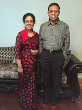
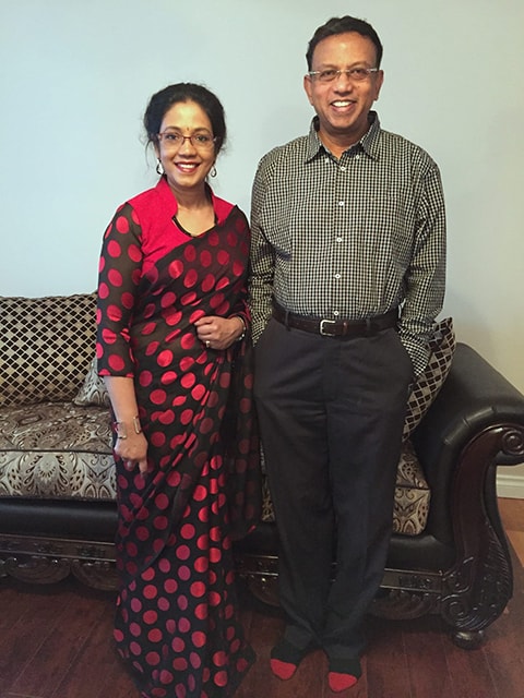
- Interviewer: James Binks Interviewees: Samuel Nalliah and Ruth (Angela) Nalliah Location of Interview: Nalliah family home Interview Date: May 29, 2023 Total Number of tracks: 2 Total Length of all Tracks: 68 min., 6 sec. Digital master recordings (wav) were recorded onto two separate audio tracks, edited and merged together and converted to mp3 for access on Heritage Burnaby Photograph information: Ruth (Angela) Nalliah with husband Samuel Nalliah WARNING: Some of the content discussed in this interview (00:40:58 – 00:57:31) regarding the Tamil genocide may be upsetting to some people.
- Scope and Content
- Item consists of a recording of an oral history interview with Samuel Nalliah and Ruth (Angela) Nalliah conducted by Burnaby Village Museum Registrar, James Binks. 00:00:00 - 00:13:30 Interview opens with introductions. Samuel (Sam) and Angela Nalliah provide biographical details including their parentage, place of birth (Sri Lanka), spoken language and education. Sam Nalliah shares details on his education while living in Sri Lanka, his later education in Wales where he obtained a Master’s Degree in Computer Science and his migration to Halifax in 1978 after obtaining a job at Dalhousie University as a systems analyst. Sam conveys how he decided to relocate from Halifax to Vancouver in 1986 and started his employment with BC Tel. Angela Nalliah shares details on her education and employment after immigrating to Canada from Sri Lanka in 1986. Angela conveys how she first lived in Ottawa, moved to Toronto in 1989 where she began working for TD bank and moved to Vancouver in 1999. 00:13:31 – 00:20:03 Sam Nalliah talks about how he and his wife Angela first met and married in 1999 and moved to Vancouver. Sam shares information on where his other family members immigrated to and why he decided to immigrate to Canada. Angela shares information on other members of her family who immigrated to Canada before her and how her uncle sponsored them all to come. 00:20:04 – 00:29:30 Sam provides further details regarding his family make up including; his first wife, his daughters (born in 1983 and 1985), his step daughter (born in 1991) and his youngest daughter (born in 2000). Sam tells how he worked as a Systems and Operations Manager at Shaughnessy Hospital and later at BC Hydro. Sam provides locations of homes that they lived in Burnaby and Vancouver. Sam and Angela describe what they liked about living in Burnaby, where their daughter attended school and where they did their shopping. 00:29:31 – 00:32:11 Angela talks about working for Prospera Credit Union from 2003 after TD bank downsized. Sam describes how they rented out their house in Vancouver and lived in a rental home in Burnaby that was owned by the City of Burnaby. Sam and Angela recollect the time period that they lived in Burnaby and Vancouver before deciding to move to Surrey in 2015. 00:32:12 – 00:35:59 Sam and Angela provide details regarding their daughter’s post-secondary education and careers. Angela talks about her social activities, volunteer work and involvement with the Thamil Cultural Society of British Columbia, the Women’s Network as well as the Westminster Bible Chapel Church in Burnaby and the Green Timbers Evangelical Covenant Church in Surrey. 00:36:00 – 00:40:57 Sam recalls hearing Prime Minster Pierre Elliott Trudeau speak about the Charter of Rights and Freedoms at Dalhousie University and the effect that his speech made on him. Sam talks about joining the National Democratic Party when Peter Julian was elected as a Member of Parliament for Burnaby. 00:40:58 – 00:57:31 (WARNING: Some of the content discussed in this portion of the interview may be upsetting to some people) Sam and Angela speak about their involvement with the Canadian Tamil Congress (CTC). Angela describes the brutal violence that she witnessed while living in Sri Lanka during the Anti-Tamil state sponsored genocide in the 1980’s. Sam and Angela recollect and discuss their views and actions pertaining to the MV Sun Sea incident where a Thai cargo ship carrying Sri Lankan Tamil refugees to British Columbia were identified as terrorists by the Canadian Government and held in detention facilities. 00:57:32 – 01:08:07 Sam reflects on what he likes about Burnaby. Angela and Sam talk about Hindu temples attended by many Tamil and Sri Lankan people living in Burnaby and the lower mainland. Angela talks about the many cultural events and celebrations that are celebrated within the Tamil and Sri Lankan community including the Pongal Festival. Angela and Sam reflect on how grateful they are to be residents of Canada.
- History
- Interviewees biographies: Samuel (Sam) Nalliah was born in Jaffna, Sri Lanka in 1949. Sam immigrated to Halifax in 1977 after obtaining a position as a systems analyst at Dalhousie University. In 1986, Sam sponsored his parents to come to Canada. In 1986, after being introduced to the milder weather in Victoria, Sam decided to move to British Columbia. He moved to Burnaby in 1990 and began working for BC Tel in Burnaby. Following his job at BC Tel, Sam worked as a Systems and Operations Manager at Shaughnessy Hospital and later at BC Hydro. Ruth (Angela) Nalliah was born in Jaffna, Sri Lanka in 1964 and immigrated to Canada in 1986. As a Tamil living in Sri Lanka in the 1980’s Angela witnessed first hand the brutal violence during the Anti-Tamil state sponsored genocide. In 1986 Angela was relieved to be able to immigrate to Canada after being sponsored by her uncle. Angela first lived and worked in Ottawa and Toronto before marrying Samuel Nalliah in Ottawa in 1999 and the couple moved to Burnaby. Angela worked for TD bank in both Toronto and Vancouver until it downsized in 2003 and she began working for Prospero Credit Union. While living in Burnaby, Angela attended the Westminster Bible Chapel and after moving to Surrey she became a member of the Green Timbers Evangelical Covenant Church. Sam and Angela Nalliah have four daughters and since moving to British Columbia they’ve lived in Vancouver, Burnaby and Surrey. Both Sam and Angela are involved with the Tamil Cultural Association of British Columbia and the Canadian Tamil Congress (CTC) as well as participates in Sri Lankan and Tamil community cultural events. Interviewer biography: James Binks has lived in the Lower Mainland since 2009 after relocating from Ontario. James holds a Bachelor of Arts in Anthropology from the University of British Columbia, where he conducted researched on heritage, environment, and globalization in India, Nepal, and Italy. At Burnaby Village Museum, James contributed to the exhibit “Truths Not Often Told: Being South Asian in Burnaby”.
- Creator
- Burnaby Village Museum
- Subjects
- Education
- Events - Festivals
- Government
- Government - Federal Government
- Migration
- Occupations
- Organizations - Political Parties
- Persons - South Asian Canadians
- Religions
- Religions - Christianity
- Religions - Hinduism
- Rights
- Rights - Human Rights
- Social Issues
- Social Issues - Racism
- Social Issues - Discrimination
- Names
- Nalliah, Ruth "Angela"
- Nalliah, Samuel "Sam"
- Canadian Tamil Congress (CTC)
- Westminster Bible Chapel
- Thamil Cultural Society of British Columbia (TCSBC)
- Responsibility
- Binks, James
- Accession Code
- BV023.16.8
- Access Restriction
- No restrictions
- Reproduction Restriction
- No known restrictions
- Date
- 1949-2023 (interview content), interviewed 29 May 2023
- Media Type
- Sound Recording
- Notes
- Title based on contents of item
- Transcription available upon request - contact Burnaby Village Museum
Images
Audio Tracks
Interview with Samuel Nalliah and Ruth (Angela) Nalliah, 1949-2023 (interview content), interviewed 29 May 2023
Interview with Samuel Nalliah and Ruth (Angela) Nalliah, 1949-2023 (interview content), interviewed 29 May 2023
https://search.heritageburnaby.ca/media/hpo/_Data/_BVM_Sound_Recordings/Oral_Histories/2023_0016_0008_003.mp3
Broadview Neighbourhood
https://search.heritageburnaby.ca/link/landmark750
- Repository
- Burnaby Heritage Planning
- Associated Dates
- 1905-1924
- Heritage Value
- Between 1905 and 1924, the Broadview neighbourhood in Burnaby was settled by almost 100 families who saw the advantage of living in an area that was served by two railway lines - the B.C. Electric Railway and the Great Northern Railway. Touted as being only a 20 minute car ride to the city centre, this neighbourhood expanded during the early 1920s with the promise of a new direct access road to the city being built by the Great Northern Railway company and new blocks being opened up on two government reserves adjoining it.
- Historic Neighbourhood
- Broadview (Historic Neighbourhood)
- Planning Study Area
- Cascade-Schou Area
Images


Duncan & Margaret McGregor Estate 'Glen-Lyon' Mansion
https://search.heritageburnaby.ca/link/landmark518
- Repository
- Burnaby Heritage Planning
- Description
- Overlooking the rich farmland of the Fraser River floodplain, 'Glen-Lyon' is an Edwardian era rural estate, with a tall, two and one-half storey plus basement wood-frame mansion, set in a pastoral and formal landscape with an associated barn and early log pond, located near a ravine and forested ar…
- Associated Dates
- 1902
- Formal Recognition
- Heritage Designation, Community Heritage Register
- Street View URL
- Google Maps Street View
- Repository
- Burnaby Heritage Planning
- Geographic Access
- Marine Drive
- Associated Dates
- 1902
- Formal Recognition
- Heritage Designation, Community Heritage Register
- Enactment Type
- Bylaw No. 12183
- Enactment Date
- 11/12/2006
- Description
- Overlooking the rich farmland of the Fraser River floodplain, 'Glen-Lyon' is an Edwardian era rural estate, with a tall, two and one-half storey plus basement wood-frame mansion, set in a pastoral and formal landscape with an associated barn and early log pond, located near a ravine and forested area adjacent to Marine Drive in South Burnaby.
- Heritage Value
- ‘Glen-Lyon’ is valued as an excellent example of a privately-owned Edwardian era country estate built at the turn of the nineteenth century. The property retains significant heritage features including the Edwardian era mansion with rustic Arts and Crafts features, and elements of a working agricultural landscape. The property was originally the Royal City Mills logging camp, and in 1900 was purchased by Duncan Campbell McGregor (1853-1929) and Margaret Jane McGregor (1875-1960), who named their estate ‘Glen-Lyon’ after Duncan McGregor’s birthplace in Perthshire, Scotland. The McGregors were active in municipal affairs and social activities, and played a significant role in the early development of Burnaby. Duncan McGregor served as a city councillor from 1909 to 1912 and was elected reeve of Burnaby in 1913. Margaret McGregor was instrumental in the formation and fundraising activities of the Victoria Order of Nurses in Burnaby. Additionally, the site is historically significant for its association with early social welfare and correctional reform. The estate was sold in 1926 to an inter-denominational religious organization called the Home of the Friendless, which used it as their B.C. headquarters. The organization was charged with several cases of abuse and neglect in 1937, after which a Royal Commission was formed that led to new legislation to regulate and license all private welfare institutions. 'Glen-Lyon' was sold to the provincial government, and was dedicated in 1939 by the Lt.-Gov. E.W. Hamber for use as the New Haven Borstal Home for Boys and Youthful Offenders (later renamed the New Haven Correction Centre). The Borstal movement originated in England in the late nineteenth century, as an alternative to sending young offenders and runaways to prisons by providing reformatories that focused on discipline and vocational skill. This site’s role as the first North American institution devoted to the Borstal School philosophy was historic, and influenced corrections programs across Canada. The site retains significant features from its development in 1939 as the Borstal School, including a large gambrel-roofed barn designed by Chief Provincial Architect Henry Whittaker of the Department of Public Works that is the only remaining structure of its kind in Burnaby. Between 1941 and 1945 the mansion housed the Provincial School for the Deaf and Blind when the Borstal School was closed temporarily as a war measure during the Second World War.
- Defining Elements
- Key elements that define the heritage character of 'Glen-Lyon' Mansion include its: - location on a sloping site with expansive southern exposure, adjacent to Marine Drive - residential form, scale and massing of the house as exemplified by its two and one-half storey height, above-ground basement and rectangular plan - Arts and Crafts elements of the house such as its stone foundation, multi-gabled roof line with steep central hipped roof, symmetrical cross-gables, side shed dormers, bellcast upper walls sheathed in cedar shingles and lower walls sheathed in narrow clapboard - original exterior features of the house such as the full width front verandah with square columns, central staircase on the southern elevation, original doors and stained glass windows; and the irregular fenestration such as double-hung 1-over-1 wooden-sash windows, bay windows, and projecting windows in the gable ends - original interior features of the house such as the U-shaped main stair designed around two symmetrically placed Ionic columns, and interior trim on the main floor including boxed beams and fireplaces - gambrel-roofed barn with roof vent with finial, sliding hay loft and access doors, small multi-pane windows, and lapped wooden siding - associated landscape features such as the original garden plantings with some exotic and many native specimen trees; the original log pond and its concrete Marine Drive causeway and culvert; rockeries and a rose garden
- Historic Neighbourhood
- Fraser Arm (Historic Neighbourhood)
- Planning Study Area
- Big Bend Area
- Architect
- Henry Whittaker
- Function
- Primary Historic--Estate
- Community
- Burnaby
- Cadastral Identifier
- 003-004-661
- Boundaries
- 'Glen-Lyon' is comprised of a single residential lot located at 4250 Marine Drive, Burnaby.
- Area
- 230873.18
- Contributing Resource
- Building
- Ownership
- Private
- Names
- McGregor, Duncan C. (1853-1929)
- Whittaker, Henry
- Home of the Friendless
- Borstal School
- New Haven Correction Centre
- Subjects
- Buildings - Heritage
- Buildings - Residential - Houses
- Buildings - Public - Detention Facilities
- Buildings - Residential
- Street Address
- 4250 Marine Drive
- Street View URL
- Google Maps Street View
Images


Hastings Barnet Road
https://search.heritageburnaby.ca/link/landmark715
- Repository
- Burnaby Heritage Planning
- Associated Dates
- 1903
- Heritage Value
- Prior to 1900, Hastings Street in Vancouver (named after Rear Admiral George Fowler Hastings, commander of Her Majesty's Pacific Coast Squadron) only extended eastward as far as Renfrew Street. By 1903, however, with operations at the Barnet Mill expanding, a direct route into Vancouver was deemed necessary and the Provincial Government ordered that Hastings be extended to connect with the rough trail known as the Barnet Road.
- Historic Neighbourhood
- Vancouver Heights (Historic Neighbourhood)
- Planning Study Area
- Burnaby Heights Area
Images


Oakalla Prison
https://search.heritageburnaby.ca/link/landmark752
- Repository
- Burnaby Heritage Planning
- Geographic Access
- Royal Oak Avenue
- Associated Dates
- 1912
- Heritage Value
- The Oakalla Prison Farm opened in 1912 and was hailed as the most modern facility of its kind. Initially designed to hold 150 men and 50 women, by the 1950s, the population was well over 1000. A working farm, the prison had its own dairy, vegetable gardens and livestock. From the beginning, the location of Oakalla on 185 acres of scenic land next to Burnaby's Deer Lake was the source of contention with residents petitioning the government to relocate the prison and by 1979 it was decided to close the farm and 64 acres of land were transferred to Burnaby for inclusion on the Deer Lake Park. In 1991, Oakalla closed forever and the buildings were demolished to make way for a new residential housing development and an expansion of the park.
- Historic Neighbourhood
- Burnaby Lake (Historic Neighbourhood)
- Planning Study Area
- Oakalla Area
Images


Ocean View Burial Park - Landscape
https://search.heritageburnaby.ca/link/landmark629
- Repository
- Burnaby Heritage Planning
- Description
- Cemetery site.
- Associated Dates
- 1919
- Street View URL
- Google Maps Street View
- Repository
- Burnaby Heritage Planning
- Geographic Access
- Imperial Street
- Associated Dates
- 1919
- Description
- Cemetery site.
- Heritage Value
- Burnaby’s landmark Ocean View Burial Park was British Columbia’s first non-sectarian cemetery created as a for-profit business enterprise. Organized by a group of local investors headed by Lieut. Col. G.H. Dorrell, the Ocean View Cemetery Company offered a place for burials that was not owned or associated with a civic government, religious or fraternal organization. The cemetery’s design was the vision of Albert F. Arnold, an officer of the Canadian Financiers Trust Company, who was “...always depressed by the lack of beauty in so many places of internment and inevitable neglect that finally reduced them to long-grassed places of unhappy memories.” One local newspaper described the landscape of the cemetery: "The design includes ornamental trees and shrubs, beautiful flower beds and smooth winding walks and drives, with a total absence of the usual somewhat ostentatious reminders of the harvest garnered by the grim reaper."
- Locality
- Alta Vista
- Historic Neighbourhood
- Alta Vista (Historic Neighbourhood)
- Planning Study Area
- Suncrest Area
- Architect
- Albert F. Arnold
- Area
- 359280.00
- Contributing Resource
- Landscape Feature
- Ownership
- Private
- Street Address
- 4000 Imperial Street
- Street View URL
- Google Maps Street View
Images


R.F. Anderson House
https://search.heritageburnaby.ca/link/landmark531
- Repository
- Burnaby Heritage Planning
- Description
- The R.F. Anderson House is a large, two-and-one-half storey Arts and Crafts style wood frame house, now located in Deer Lake Park, built as a family home and now used as institutional offices.
- Associated Dates
- 1912
- Formal Recognition
- Heritage Designation, Community Heritage Register
- Other Names
- Robert Fenwick & Bessie Anderson House, Anderson Residence
- Street View URL
- Google Maps Street View
- Repository
- Burnaby Heritage Planning
- Other Names
- Robert Fenwick & Bessie Anderson House, Anderson Residence
- Geographic Access
- Deer Lake Avenue
- Associated Dates
- 1912
- Formal Recognition
- Heritage Designation, Community Heritage Register
- Enactment Type
- Bylaw No. 9807
- Enactment Date
- 23/11/1992
- Description
- The R.F. Anderson House is a large, two-and-one-half storey Arts and Crafts style wood frame house, now located in Deer Lake Park, built as a family home and now used as institutional offices.
- Heritage Value
- The R.F. Anderson House contributes to the overall stylistic ambiance of the area and demonstrates that a range of architectural features can be read as a cohesive whole. Although designed primarily in the British Arts and Crafts genre, as were other residences around Deer Lake, it also displays some influences of the popular Craftsman style. It was constructed in the Deer Lake Crescent subdivision, which was originally promoted as an upper class neighbourhood. It represents one of the first residential developments in the City of Burnaby that required buildings to be of a specific value, thus demonstrating the desire for exclusivity among the successful businessmen who chose to settle in the area. The house and grounds illustrate the social, cultural, lifestyle and leisure sensibilities of a successful local businessman and his family in the early twentieth century; Anderson was a New Westminster hardware merchant and Justice of the Peace. The development of the house and grounds within a controlled suburban context also illustrate the values of the owners in the Deer Lake Crescent subdivision, such as social aspiration, racial exclusivity, demonstration of architectural taste, importance of a landscaped garden, and the provision of facilities for fashionable leisure pursuits such as lawn tennis. The estate makes an important contribution to the residential grouping now preserved within Deer Lake Park, and demonstrates the broad social mix of those who chose to live in the area at a time when it was in transition from a market gardening area to a more exclusive residential community. The R.F. Anderson House is important for its association with local architect Frank William Macey (1863-1935), the first resident architect in Burnaby. Macey was born and trained in England where he was well-respected for having published two standard texts for the architectural profession. He settled in Burnaby in the first decade of the twentieth century and obtained a number of commissions from prominent businessmen who were building grand homes in the new community of Deer Lake. He designed these houses mostly in the British Arts and Crafts style.
- Defining Elements
- Key elements that define the heritage character of the R.F. Anderson House include its: - location within a park setting in relation to the W.J. Mathers House - irregular massing of the exterior and its cladding of drop-siding, with half-timbering and rough-cast stucco in the gables - picturesque irregular roofline, including an alteration in pitch over the front verandah, with cedar shingle cladding - interior plan with its generous entrance hall, staircase, and massive staircase window with leaded-lights - multiple-assembly wooden-sash casement windows - quality of interior features such as the Douglas Fir woodwork (some with original varnish finish); original hardware supplied by Anderson's hardware company; and original fireplaces with ornate tile surrounds - setting with the imprint of the lawn tennis court, now a garden terrace, and some of the original plantings
- Locality
- Deer Lake Park
- Historic Neighbourhood
- Burnaby Lake (Historic Neighbourhood)
- Planning Study Area
- Douglas-Gilpin Area
- Architect
- Frank William Macey
- Function
- Primary Current--Government Office
- Primary Historic--Single Dwelling
- Community
- Burnaby
- Cadastral Identifier
- P.I.D. No. 007-525-931 Legal Description: North 225 feet Lot 'C', District Lot 79, Group 1, New Westminster District, Plan 6884
- Boundaries
- The R.F. Anderson House is comprised of a single municipally-owned property located at 6450 Deer Lake Avenue, Burnaby.
- Area
- 63,100.00
- Contributing Resource
- Building
- Landscape Feature
- Ownership
- Public (local)
- Documentation
- Heritage Site Files: PC77000 20. City of Burnaby Planning and Building Department, 4949 Canada Way, Burnaby, B.C., V5G 1M2
- Names
- Macey, Frank W.
- Street Address
- 6450 Deer Lake Avenue
- Street View URL
- Google Maps Street View
Images


Russian Submarines at Barnet
https://search.heritageburnaby.ca/link/landmark748
- Repository
- Burnaby Heritage Planning
- Associated Dates
- 1915-1917
- Heritage Value
- This site was a top secret site where 460 men worked on the assembly of five submarines for the Russian Navy during World War I. The Seattle contractor was forbidden from doing the work in the US because of American neutrality regulations and he set up the secret plant here without the knowledge of the Canadian Government.
- Historic Neighbourhood
- Barnet (Historic Neighbourhood)
- Planning Study Area
- Burnaby Mountain Area
Images


Certificate of Canadian Citizenship issued to Quon Lip Lee
https://search.heritageburnaby.ca/link/museumdescription16718
- Repository
- Burnaby Village Museum
- Date
- 6 Oct. 1966
- Collection/Fonds
- Quon Lip Lee fonds
- Description Level
- Item
- Physical Description
- 1 photograph (tiff)
- Scope and Content
- Item consists of a Certificate of Canadian Citizenship issued to Quon Lip Lee on October 6, 1966. The back of the certificate includes vitial information including date of birth, marital status and date of issue.
- Repository
- Burnaby Village Museum
- Collection/Fonds
- Quon Lip Lee fonds
- Description Level
- Item
- Physical Description
- 1 photograph (tiff)
- Scope and Content
- Item consists of a Certificate of Canadian Citizenship issued to Quon Lip Lee on October 6, 1966. The back of the certificate includes vitial information including date of birth, marital status and date of issue.
- Creator
- Government of Canada
- Names
- Lee, Quon Lip
- Accession Code
- BV021.18.2
- Access Restriction
- No restrictions
- Reproduction Restriction
- May be restricted by third party rights
- Date
- 6 Oct. 1966
- Media Type
- Textual Record
- Photograph
- Scan Resolution
- 600
- Scan Date
- April 8, 2021
- Scale
- 100
- Notes
- Title based on contents of item
Images

![Head tax certificate issued to Lee Quon Lep [Quan Lip Lee], 1921-1949 (date of original), copied 2021 thumbnail](/media/hpo/_Data/_BVM_Textual_Records/2021/2021_0018_0001_001.jpg?width=280)
Head tax certificate issued to Lee Quon Lep [Quan Lip Lee]
https://search.heritageburnaby.ca/link/museumdescription16717
- Repository
- Burnaby Village Museum
- Date
- 1921-1949 (date of original), copied 2021
- Collection/Fonds
- Quon Lip Lee fonds
- Description Level
- Item
- Physical Description
- 1 photograph (tiff)
- Scope and Content
- Item consists of a head tax certificate issued by the Dominion of Canada - Immigration Branch - Department of the (Interior) issued to Lee Quon Lep [sic] [Quon Lip Lee]. The certificate was first issued on December 12, 1921 and includes certification stamps on the front along with a photograph of Q…
- Repository
- Burnaby Village Museum
- Collection/Fonds
- Quon Lip Lee fonds
- Description Level
- Item
- Physical Description
- 1 photograph (tiff)
- Scope and Content
- Item consists of a head tax certificate issued by the Dominion of Canada - Immigration Branch - Department of the (Interior) issued to Lee Quon Lep [sic] [Quon Lip Lee]. The certificate was first issued on December 12, 1921 and includes certification stamps on the front along with a photograph of Quan Lip Lee. Certification stamps on the verso of the certificate were issued by Canadian and Chinese Immigration authorities between 1924 and 1949. Information on the front of the certificate reads "DOMINION OF CANADA / IMMIGRATION BRANCH - DEPARTMENT.../ RECEIVED FRO.../ Lee Quon Lep whose photograph is attached / hereto on the date and at the place hereunder mentioned the sum / of five Hundred Dollars being the head tax due under the / provisions of the Chinese Immigration Act. / The above mentioned party claims / to be a native of Gong Doey Lee / in the district of Sun Way / of the age of 12 years arrived or landed / at Vancouver on the 28th day of / November 1921 ex Empress [sic] of Asia / The declaration in this case is C.I.4 No. 3716 / Dated at Vancouver on Dec 12, 1921_19_/ (signature) / CONTROLLER OF CHINESE IMMIGRATION". Printed text on verso of certificate reads "IMPORTANT / IT IS NECESSARY THAT THIS / CERTIFICATE BE CAREFULLY / PRESERVED AS IT IS OF VALUE / AS A MEANS OF IDENTIFICATION" along with Chinese language characters printed vertically below.
- Creator
- Government of Canada
- Names
- Lee, Quon Lip
- Accession Code
- BV021.18.1
- Access Restriction
- No restrictions
- Reproduction Restriction
- No known restrictions
- Date
- 1921-1949 (date of original), copied 2021
- Media Type
- Textual Record
- Photograph
- Scan Resolution
- 600
- Scan Date
- April 8, 2021
- Scale
- 100
- Notes
- Title based on contents of item
Images
![Head tax certificate issued to Lee Quon Lep [Quan Lip Lee], 1921-1949 (date of original), copied 2021 thumbnail](/media/hpo/_Data/_BVM_Textual_Records/2021/2021_0018_0001_001.jpg)

Map of the Dominion of Canada
https://search.heritageburnaby.ca/link/museumdescription18944
- Repository
- Burnaby Village Museum
- Date
- 1911
- Collection/Fonds
- Burnaby Village Museum Map collection
- Description Level
- Item
- Physical Description
- 1 map : col. lithographic print on white paper ; 49.5 x 88.5 cm on sheet 63.5 x 90.5 cm
- Scope and Content
- Item consists of a "MAP OF THE DOMINION OF CANADA" produced by the Department of the Interior in 1911 . Text in lower border below map reads "THIS MAP IS PRESENTED WITH THE COMPLIMENTS OF THE ROYAL BANK OF CANADA" "WITH ITS FORTY-SECOND ANNUAL REPORT, 31st DECEMBER, 1911" at bottom centre, with lis…
- Repository
- Burnaby Village Museum
- Collection/Fonds
- Burnaby Village Museum Map collection
- Description Level
- Item
- Physical Description
- 1 map : col. lithographic print on white paper ; 49.5 x 88.5 cm on sheet 63.5 x 90.5 cm
- Material Details
- Scale: 100 miles = 1 inch
- Scope and Content
- Item consists of a "MAP OF THE DOMINION OF CANADA" produced by the Department of the Interior in 1911 . Text in lower border below map reads "THIS MAP IS PRESENTED WITH THE COMPLIMENTS OF THE ROYAL BANK OF CANADA" "WITH ITS FORTY-SECOND ANNUAL REPORT, 31st DECEMBER, 1911" at bottom centre, with list of branches in Canada and in other countries; at left is list of "PRINCIPAL FOREIGN CORRESPONDENTS"; at right is general information, "INCORPORATED 1869", "HEAD OFFICE MONTREAL", with "CAPITAL PAID UP", "RESERVE FUNDS", "AGGREGATE ASSETS" all listed, and "BOARD OF DIRECTORS" listed. Map shows proposed additions to Quebec, Ontario and Manitoba. Provincial and territorial borders, shipping routes, railway lines are identified. Two charts at upper right of distances, red print, one for distances in Canada from Montreal, the other for Montreal, Halifax and Churchill to foreign ports.
- Publisher
- Royal Bank of Canada
- Accession Code
- BV988.56.4
- Access Restriction
- No restrictions
- Reproduction Restriction
- No known restrictions
- Date
- 1911
- Media Type
- Cartographic Material
- Notes
- Title based on contents of map

Sketch map of the Province of British Columbia showing mining divisions
https://search.heritageburnaby.ca/link/museumdescription18946
- Repository
- Burnaby Village Museum
- Date
- 1907
- Collection/Fonds
- Burnaby Village Museum Map collection
- Description Level
- Item
- Physical Description
- 1 map : col. lithographic print on paper ; 52 x 59 cm
- Scope and Content
- Item consists of a map titled "Sketch map of the Province of / British Columbia / Showing Mining Divisions"; "Department of Mines, / Victoria, 1907". Map includes wagon roads and trails and geographic disticts.
- Repository
- Burnaby Village Museum
- Collection/Fonds
- Burnaby Village Museum Map collection
- Description Level
- Item
- Physical Description
- 1 map : col. lithographic print on paper ; 52 x 59 cm
- Material Details
- Scale not determinable
- Scope and Content
- Item consists of a map titled "Sketch map of the Province of / British Columbia / Showing Mining Divisions"; "Department of Mines, / Victoria, 1907". Map includes wagon roads and trails and geographic disticts.
- Accession Code
- HV977.37.172
- Access Restriction
- No restrictions
- Reproduction Restriction
- No known restrictions
- Date
- 1907
- Media Type
- Cartographic Material
- Scan Resolution
- 600
- Scan Date
- 2023-08-17
- Notes
- Title based on contents of map
- Stamp on verso of map reads: "Compliments of Vancouver Tourist Bureau"
Zoomable Images


Subdivision plans in New Westminster District Group 1 – Burnaby, Vancouver and map - Canada Department of Mines
https://search.heritageburnaby.ca/link/museumdescription6994
- Repository
- Burnaby Village Museum
- Date
- 1890-1909
- Collection/Fonds
- Burnaby Village Museum Map collection
- Description Level
- File
- Physical Description
- 1 plan : graphite on paper + 2 plans : black ink on paper + 1 map : col. on paper mounted on 2 sides of cardboard 76 x 102 cm
- Scope and Content
- Item consists of a large board with one New Westminster District subdivision plan mounted on one side and two New Westminster District subdivision plans and one colour map mounted on the other side. Side A: 1. "Plan / of Subdivision of / Blocks 2, 3, 4, 5, 6 / Lot 77 / Group 1 / New Westminster D…
- Repository
- Burnaby Village Museum
- Collection/Fonds
- Burnaby Village Museum Map collection
- Description Level
- File
- Physical Description
- 1 plan : graphite on paper + 2 plans : black ink on paper + 1 map : col. on paper mounted on 2 sides of cardboard 76 x 102 cm
- Material Details
- Scales 1:720 and 1:1200 and 1:.00001578
- Scope and Content
- Item consists of a large board with one New Westminster District subdivision plan mounted on one side and two New Westminster District subdivision plans and one colour map mounted on the other side. Side A: 1. "Plan / of Subdivision of / Blocks 2, 3, 4, 5, 6 / Lot 77 / Group 1 / New Westminster District / BC. / Scale 100 feet = 1 inch", "Deposited 8th day / of April 1890 / Mowileg [sic] / Dist. Regt". Plan is drawn in graphite with annotations: "AB_Parts_lettered_are_lots_in / the_different_subdivisions" / "Owners: / James E. Hall / P.S.Cabilan [sic] by his attorney Joseph Hall / Joseph Hall / Eliza J. Shannon / John Harrison"; "This plan is correct and is prepared under the / provisions of the Land Registry Act" ; signed by: "Gordon Herman & Burwell / Dominion & Provincial Land Surveryors / Vancouver March 19th/90" . Plan is initialed by: "RB" [sic] (in blue pencil crayon) and measures: 99.5 x 65 cm (Geographic location: Burnaby) Side B: 1. Map titled "Canada / Department of Mines / Geological Survey Branch" / "Hon.W Templeton, Minister / A.P. Low, Deputy Minister / R.W. Brock, Acting Director", Vol. XXXI, Plate I / Compiled under the direction of / James White, F.R.G.S. Geographer /Dep. of Interior". Note above map reads: "To illustrate Mr. James Barrowman's report as Delegate at the Excursion - meeting of the Canadian Mining Institute", "The instiitution of Mining Engineers / Transactions 1908 - 1909", "The Mining Institute of Scotland / Transactions 1908-1909". Map identifies minerals and includes a Legend and Scale: 100 miles = 1 inch 2. "Plan / of Subdivision of / Lot 4 / of Subdivision of / Lot 87. Gr. 1 / New Westminster District / Scale 60' = 1in." Plan is initialed by: "RB" [sic] along with a note "also Board / 48" (in blue pencil crayon) (Geographic location: Burnaby) 3. Plan of "Lot 335 / G. 1" west of Boundary Road and north of River Road - Vancouver. (Geographic location: Vancouver)
- Publisher
- The Mining Institute of Scotland
- Geographic Access
- Vancouver
- Accession Code
- HV977.93.25
- Access Restriction
- No restrictions
- Reproduction Restriction
- No known restrictions
- Date
- 1890-1909
- Media Type
- Cartographic Material
- Scan Resolution
- 300
- Scale
- 72
- Notes
- Title based on contents of file
- Scale is measured in feet and miles.
- The term "Lot" often refers to "District Lot"
Images


![B.C. Parliament Building in Victoria, [ca. 1920] thumbnail](/media/hpo/_Data/_BVM_Images/1985/1985_5899_0003_001.jpg?width=280)
B.C. Parliament Building in Victoria
https://search.heritageburnaby.ca/link/museumdescription1527
- Repository
- Burnaby Village Museum
- Date
- [ca. 1920]
- Collection/Fonds
- Burnaby Village Museum Photograph collection
- Description Level
- Item
- Physical Description
- 1 photograph : b&w ; 6.5 x 9 cm
- Scope and Content
- Photograph of the British Columbia Parliament Buildings, home of the Legislative Assembly of British Columbia located in Victoria. There are people standing on the steps to the front entrance. There is a sign on the lawn in front of the parliament buliding that reads, "PLEASE KEEP OFF THE GRASS."
- Repository
- Burnaby Village Museum
- Collection/Fonds
- Burnaby Village Museum Photograph collection
- Description Level
- Item
- Physical Description
- 1 photograph : b&w ; 6.5 x 9 cm
- Material Details
- stamped on verso, t. "159"
- Scope and Content
- Photograph of the British Columbia Parliament Buildings, home of the Legislative Assembly of British Columbia located in Victoria. There are people standing on the steps to the front entrance. There is a sign on the lawn in front of the parliament buliding that reads, "PLEASE KEEP OFF THE GRASS."
- Subjects
- Government - Provincial Government
- Geographic Access
- Victoria
- Accession Code
- BV985.5899.3
- Access Restriction
- No restrictions
- Reproduction Restriction
- No known restrictions
- Date
- [ca. 1920]
- Media Type
- Photograph
- Scan Resolution
- 600
- Scan Date
- 2024-02-27
- Notes
- Title based on contents of photograph
Images
![B.C. Parliament Building in Victoria, [ca. 1920] thumbnail](/media/hpo/_Data/_BVM_Images/1985/1985_5899_0003_001.jpg)
![CCF MLA's in their seats in the B.C. Legislature, [between 1949 and 1956] thumbnail](/media/hpo/_Data/_BVM_Images/2013/2013_0012_0056_001.jpg?width=280)
CCF MLA's in their seats in the B.C. Legislature
https://search.heritageburnaby.ca/link/museumdescription3699
- Repository
- Burnaby Village Museum
- Date
- [between 1949 and 1956]
- Collection/Fonds
- Harold Edward Winch collection
- Description Level
- Item
- Physical Description
- 1 photograph : sepia ; 20 x 25 cm
- Scope and Content
- Photograph of Co-operative Commonwealth Federation (CCF) Members of the Legislative Assembly at their seats inside of the British Columbia Parliament buildings in Victoria. Photograph is taken inside the legislature. Members are identified as; Frank Calder, Rupert Haggen, Leo Nimsick, Frank Mitchel…
- Repository
- Burnaby Village Museum
- Collection/Fonds
- Harold Edward Winch collection
- Description Level
- Item
- Physical Description
- 1 photograph : sepia ; 20 x 25 cm
- Scope and Content
- Photograph of Co-operative Commonwealth Federation (CCF) Members of the Legislative Assembly at their seats inside of the British Columbia Parliament buildings in Victoria. Photograph is taken inside the legislature. Members are identified as; Frank Calder, Rupert Haggen, Leo Nimsick, Frank Mitchell, Arthur Turner, Harold Winch, Ernest Winch, and Ran Harding.
- Subjects
- Government - Provincial Government
- Officials - Elected Officials
- Organizations - Political Parties
- Names
- Winch, Ernest "Ernie"
- Winch, Harold Edward
- Calder, Frank
- Haggen, Rupert
- Nimsick, Leo
- Mitchell, Frank
- Turner, Arthur
- Harding, Ran
- Co-operative Commonwealth Federation "CCF"
- Accession Code
- BV013.12.56
- Access Restriction
- No restrictions
- Reproduction Restriction
- May be restricted by third party rights
- Date
- [between 1949 and 1956]
- Media Type
- Photograph
- Photographer
- Portley, John S.
- Notes
- Title based on contents of photograph
- Handwritten annotations on recto of photograph provide identification and read from left to right: "Frank Calder_Rupert Hagen_Leo Nimsick_Frank Mitchell / Arthur Turner_Harold Winch_Ernest Winch_Ran Harding / CCF MLA's / in their seats in the B.C. Legislature"
- Photograph is a part of original scrapbook Item BV013.12.11
- Note on verso of photograph reads: "Our fighting '8' in the BC Legislature : / Were we downhearted? / Yes & No / HW"
- Stamp in blue ink on verso of photograph reads: "John S. Portley [sic]"
Images
![CCF MLA's in their seats in the B.C. Legislature, [between 1949 and 1956] thumbnail](/media/hpo/_Data/_BVM_Images/2013/2013_0012_0056_001.jpg)
![Co-operative Commonwealth Federation party members, [194-?] thumbnail](/media/hpo/_Data/_BVM_Images/2013/2013_0012_0088_001.jpg?width=280)
Co-operative Commonwealth Federation party members
https://search.heritageburnaby.ca/link/museumdescription3731
- Repository
- Burnaby Village Museum
- Date
- [194-?]
- Collection/Fonds
- Harold Edward Winch collection
- Description Level
- Item
- Physical Description
- 1 photograph : b&w ; 12.7 x 18 cm
- Scope and Content
- Item is a photograph of Ernest "Ernie" Winch, Grace MacInnis, and Grant MacNeil, all of whom served as Co-operative Commonwealth Federation (CCF) MLAs in the 1940s.
- Repository
- Burnaby Village Museum
- Collection/Fonds
- Harold Edward Winch collection
- Description Level
- Item
- Physical Description
- 1 photograph : b&w ; 12.7 x 18 cm
- Scope and Content
- Item is a photograph of Ernest "Ernie" Winch, Grace MacInnis, and Grant MacNeil, all of whom served as Co-operative Commonwealth Federation (CCF) MLAs in the 1940s.
- Subjects
- Government - Provincial Government
- Accession Code
- BV013.12.88
- Date
- [194-?]
- Media Type
- Photograph
- Notes
- Title based on contents of photograph
- Photograph is a part of original scrapbook Item BV013.12.11
Images
![Co-operative Commonwealth Federation party members, [194-?] thumbnail](/media/hpo/_Data/_BVM_Images/2013/2013_0012_0088_001.jpg)