Narrow Results By
Subject
- Accidents 2
- Accidents - Automobile Accidents 17
- Accidents - Train Accidents 6
- Advertising Medium - Signs and Signboards
- Aerial Photographs 8
- Agricultural Tools and Equipment 5
- Agricultural Tools and Equipment - Cultivators 2
- Agricultural Tools and Equipment - Gardening Equipment 1
- Agricultural Tools and Equipment - Plows 1
- Agricultural Tools and Equipment - Tractors 1
- Agriculture 12
- Agriculture - Crops 8
Person / Organization
- A. MacKenzie and Company Jubilee Store 2
- Battersby, Frank 1
- British Columbia Organization to Fight Racism 1
- Burnaby Art Gallery 1
- Burnaby Central Secondary School 1
- Burnaby Shoe Hospital 1
- Canadian Farmworkers Union 1
- Canadian Pacific Railway Company 1
- Cascade Drive-In Theatre 1
- Chan, Puy Yuen 4
- Chinese Market Gardens 1
- Chouhan, Raj 1
1160 Douglas Rd
https://search.heritageburnaby.ca/link/archivedescription94327
- Repository
- City of Burnaby Archives
- Date
- December 1994
- Collection/Fonds
- Grover, Elliott & Co. Ltd. fonds
- Description Level
- File
- Physical Description
- 22 photographs : col. negatives ; 35 mm
- Scope and Content
- Photographs of the exterior of a three-storey commerical building located at 1160 Douglas Road.
- Repository
- City of Burnaby Archives
- Date
- December 1994
- Collection/Fonds
- Grover, Elliott & Co. Ltd. fonds
- Physical Description
- 22 photographs : col. negatives ; 35 mm
- Description Level
- File
- Record No.
- 622-112
- Access Restriction
- No restrictions
- Reproduction Restriction
- No restrictions
- Accession Number
- 2017-39
- Scope and Content
- Photographs of the exterior of a three-storey commerical building located at 1160 Douglas Road.
- Media Type
- Photograph
- Photographer
- Young, Richard
- Notes
- Transcribed title
- Title transcribed from envelope photographs were originally housed in
- File no. 94-424-B
- Geographic Access
- Douglas Road
- Street Address
- 1160 Douglas Road
- Historic Neighbourhood
- Vancouver Heights (Historic Neighbourhood)
- Planning Study Area
- Willingdon Heights Area
2761 North Rd
https://search.heritageburnaby.ca/link/archivedescription94334
- Repository
- City of Burnaby Archives
- Date
- April 1995
- Collection/Fonds
- Grover, Elliott & Co. Ltd. fonds
- Description Level
- File
- Physical Description
- 24 photographs : col. negatives ; 35 mm
- Scope and Content
- Photographs of an undeveloped property located at 2761 North Road - an address that no longer exists. Three large billboards are posted at the edge of the property, facing onto the street.
- Repository
- City of Burnaby Archives
- Date
- April 1995
- Collection/Fonds
- Grover, Elliott & Co. Ltd. fonds
- Physical Description
- 24 photographs : col. negatives ; 35 mm
- Description Level
- File
- Record No.
- 622-119
- Access Restriction
- No restrictions
- Reproduction Restriction
- No restrictions
- Accession Number
- 2017-39
- Scope and Content
- Photographs of an undeveloped property located at 2761 North Road - an address that no longer exists. Three large billboards are posted at the edge of the property, facing onto the street.
- Media Type
- Photograph
- Photographer
- Young, Richard
- Notes
- Transcribed title
- Title transcribed from envelope photographs were originally housed in
- File no. 95-167-B
- Geographic Access
- North Road
- Historic Neighbourhood
- Burquitlam (Historic Neighbourhood)
- Planning Study Area
- Lyndhurst Area
4250 Grange St
https://search.heritageburnaby.ca/link/archivedescription93892
- Repository
- City of Burnaby Archives
- Date
- June 1993
- Collection/Fonds
- Grover, Elliott & Co. Ltd. fonds
- Description Level
- File
- Physical Description
- 25 photographs : col. negatives ; 35 mm
- Scope and Content
- Photographs of an undeveloped property located at 4250 Grange Street - an address that no longer exists. The property's current address is 5833 Wilson Avenue. A billboard in front of the property reads: Paramount / Coming Soon / Two 21-Storey Luxury Twin Towers".
- Repository
- City of Burnaby Archives
- Date
- June 1993
- Collection/Fonds
- Grover, Elliott & Co. Ltd. fonds
- Physical Description
- 25 photographs : col. negatives ; 35 mm
- Description Level
- File
- Record No.
- 622-075
- Access Restriction
- No restrictions
- Reproduction Restriction
- No restrictions
- Accession Number
- 2017-39
- Scope and Content
- Photographs of an undeveloped property located at 4250 Grange Street - an address that no longer exists. The property's current address is 5833 Wilson Avenue. A billboard in front of the property reads: Paramount / Coming Soon / Two 21-Storey Luxury Twin Towers".
- Media Type
- Photograph
- Notes
- Transcribed title
- Title transcribed from envelope photographs were originally housed in
- File no. 93-284-B
- Photographer identified as "J.C."
- Geographic Access
- Wilson Avenue
- Grange Street
- Street Address
- 5833 Wilson Avenue
- Historic Neighbourhood
- Central Park (Historic Neighbourhood)
- Planning Study Area
- Garden Village Area
5744 Byrne Rd
https://search.heritageburnaby.ca/link/archivedescription94345
- Repository
- City of Burnaby Archives
- Date
- January 1993
- Collection/Fonds
- Grover, Elliott & Co. Ltd. fonds
- Description Level
- File
- Physical Description
- 51 photographs : col. negatives ; 35 mm
- Scope and Content
- Photographs of commercial and undeveloped properties located in the Big Bend area, including 5744 Byrne Road, Lowland Drive, and 4853 Byrne Road.
- Repository
- City of Burnaby Archives
- Date
- January 1993
- Collection/Fonds
- Grover, Elliott & Co. Ltd. fonds
- Physical Description
- 51 photographs : col. negatives ; 35 mm
- Description Level
- File
- Record No.
- 622-130
- Access Restriction
- No restrictions
- Reproduction Restriction
- No restrictions
- Accession Number
- 2017-39
- Scope and Content
- Photographs of commercial and undeveloped properties located in the Big Bend area, including 5744 Byrne Road, Lowland Drive, and 4853 Byrne Road.
- Media Type
- Photograph
- Notes
- Transcribed title
- Title transcribed from envelope photographs were originally housed in
- File no. 95-285-B
- Sticky note adhered to print of photograph 622-130-036 reads: "Lowland Drive"
- Sticky note adhered to print of photograph 622-130-039 reads: "4853 Byrne"
- Photographer identified as "L.D."
- Geographic Access
- Byrne Road
- Lowland Drive
- Street Address
- 5744 Byrne Road
- 4853 Byrne Road
- Historic Neighbourhood
- Fraser Arm (Historic Neighbourhood)
- Planning Study Area
- Big Bend Area
8980 Fraserwood Crt
https://search.heritageburnaby.ca/link/archivedescription94326
- Repository
- City of Burnaby Archives
- Date
- December 1994
- Collection/Fonds
- Grover, Elliott & Co. Ltd. fonds
- Description Level
- File
- Physical Description
- 24 photographs : col. negatives ; 35 mm
- Scope and Content
- Photographs of an undeveloped property located at 8980 Fraserwood Court. A Sutton Group real estate sign on the property advertises the site as the Fraserwood Corporate Centre with strata warehouse and office flex space. File also contains photographs of the commerical building adjacent to the si…
- Repository
- City of Burnaby Archives
- Date
- December 1994
- Collection/Fonds
- Grover, Elliott & Co. Ltd. fonds
- Physical Description
- 24 photographs : col. negatives ; 35 mm
- Description Level
- File
- Record No.
- 622-111
- Access Restriction
- No restrictions
- Reproduction Restriction
- No restrictions
- Accession Number
- 2017-39
- Scope and Content
- Photographs of an undeveloped property located at 8980 Fraserwood Court. A Sutton Group real estate sign on the property advertises the site as the Fraserwood Corporate Centre with strata warehouse and office flex space. File also contains photographs of the commerical building adjacent to the site.
- Media Type
- Photograph
- Notes
- Transcribed title
- Title transcribed from envelope photographs were originally housed in
- File no. 94-422-B
- Photographer identified as "L.D."
- Geographic Access
- Fraserwood Court
- Street Address
- 8980 Fraserwood Court
- Historic Neighbourhood
- Fraser Arm (Historic Neighbourhood)
- Planning Study Area
- Big Bend Area
![Big Bend flood, [1999] thumbnail](/media/hpo/_Data/_Archives_Images/_Unrestricted/535/535-3167-1.jpg?width=280)
Big Bend flood
https://search.heritageburnaby.ca/link/archivedescription98087
- Repository
- City of Burnaby Archives
- Date
- [1999]
- Collection/Fonds
- Burnaby NewsLeader photograph collection
- Description Level
- File
- Physical Description
- 3 photographs (tiff) : col.
- Scope and Content
- File contains photographs of unidentified people after a flood in the Big Bend area. Photographs depict a person standing in a farm field and adjusting a plant at Wing Wong's Nursery, and another person wearing a hard hat and posing with a construction vehicle.
- Repository
- City of Burnaby Archives
- Date
- [1999]
- Collection/Fonds
- Burnaby NewsLeader photograph collection
- Physical Description
- 3 photographs (tiff) : col.
- Description Level
- File
- Record No.
- 535-3167
- Access Restriction
- No restrictions
- Reproduction Restriction
- No restrictions
- Accession Number
- 2018-12
- Scope and Content
- File contains photographs of unidentified people after a flood in the Big Bend area. Photographs depict a person standing in a farm field and adjusting a plant at Wing Wong's Nursery, and another person wearing a hard hat and posing with a construction vehicle.
- Subjects
- Agriculture - Farms
- Buildings - Agricultural - Nurseries
- Construction Tools and Equipment
- Natural Phenomena - Floods
- Media Type
- Photograph
- Notes
- Title based on original file name
- Collected by editorial for use in a May 1999 issue of the Burnaby NewsLeader
- Geographic Access
- Marine Drive
- Street Address
- 4892 Marine Drive
- Historic Neighbourhood
- Fraser Arm (Historic Neighbourhood)
- Planning Study Area
- Big Bend Area
Images
![Big Bend flood, [1999] thumbnail](/media/hpo/_Data/_Archives_Images/_Unrestricted/535/535-3167-1.jpg)
![Burnaby Unemployed Action Association strike, [194-] thumbnail](/media/hpo/_Data/_BVM_Images/2000/200200500004.jpg?width=280)
Burnaby Unemployed Action Association strike
https://search.heritageburnaby.ca/link/museumdescription1641
- Repository
- Burnaby Village Museum
- Date
- [194-]
- Collection/Fonds
- Burnaby Village Museum Photograph collection
- Description Level
- Item
- Physical Description
- 1 photograph : b& w ; 11.5 x 17 cm
- Scope and Content
- Photograph of people in winter coats picketing inbetween cars in front of an unidentified building. A man holds a sign that reads, "BURNABY UNEMPLOYED ACTION ASSN."
- Repository
- Burnaby Village Museum
- Collection/Fonds
- Burnaby Village Museum Photograph collection
- Description Level
- Item
- Physical Description
- 1 photograph : b& w ; 11.5 x 17 cm
- Scope and Content
- Photograph of people in winter coats picketing inbetween cars in front of an unidentified building. A man holds a sign that reads, "BURNABY UNEMPLOYED ACTION ASSN."
- Accession Code
- BV002.50.4
- Access Restriction
- No restrictions
- Reproduction Restriction
- May be restricted by third party rights
- Date
- [194-]
- Media Type
- Photograph
- Scan Resolution
- 600
- Scan Date
- 09-Jun-09
- Scale
- 100
- Notes
- Title based on contents of photograph
Images
![Burnaby Unemployed Action Association strike, [194-] thumbnail](/media/hpo/_Data/_BVM_Images/2000/200200500004.jpg)
![Canadian Pacific Railway emblem, [between 1930 and 1949] thumbnail](/media/hpo/_Data/_BVM_Images/1985/1985_6114_0012_001.jpg?width=280)
Canadian Pacific Railway emblem
https://search.heritageburnaby.ca/link/museumdescription3241
- Repository
- Burnaby Village Museum
- Date
- [between 1930 and 1949]
- Collection/Fonds
- Burnaby Village Museum Photograph collection
- Description Level
- Item
- Physical Description
- 1 photograph : b&w ; 5.5 x 8 cm
- Scope and Content
- Photograph of the sign on the back of train a car gate. The sign is circular in shape with a "Canadian Pacific Railway Lines" emblem in the center bordered by the words " - Chinook - Calgary -Edmonton."
- Repository
- Burnaby Village Museum
- Collection/Fonds
- Burnaby Village Museum Photograph collection
- Description Level
- Item
- Physical Description
- 1 photograph : b&w ; 5.5 x 8 cm
- Scope and Content
- Photograph of the sign on the back of train a car gate. The sign is circular in shape with a "Canadian Pacific Railway Lines" emblem in the center bordered by the words " - Chinook - Calgary -Edmonton."
- Accession Code
- BV985.6114.12
- Access Restriction
- No restrictions
- Reproduction Restriction
- No known restrictions
- Date
- [between 1930 and 1949]
- Media Type
- Photograph
- Scan Resolution
- 600
- Scan Date
- 2024-03-12
- Notes
- Title based on contents of photograph
- Stamp on verso of photograph reads: "831"
Images
![Canadian Pacific Railway emblem, [between 1930 and 1949] thumbnail](/media/hpo/_Data/_BVM_Images/1985/1985_6114_0012_001.jpg)
![Canoe floating on flooded farm, [1948] thumbnail](/media/hpo/_Data/_BVM_Images/2017/2017_0024_0012_001.jpg?width=280)
Canoe floating on flooded farm
https://search.heritageburnaby.ca/link/museumdescription4059
- Repository
- Burnaby Village Museum
- Date
- [1948]
- Collection/Fonds
- Julie Lee and Cecil Lee family fonds
- Description Level
- Item
- Physical Description
- 1 photograph (tiff) : sepia ; 1000 dpi
- Scope and Content
- Photograph of Suey Ying Jung (Laura) and Puy Yuen Chan in a canoe on the flooded family farm; background contains trees and a building.
- Repository
- Burnaby Village Museum
- Collection/Fonds
- Julie Lee and Cecil Lee family fonds
- Description Level
- Item
- Physical Description
- 1 photograph (tiff) : sepia ; 1000 dpi
- Scope and Content
- Photograph of Suey Ying Jung (Laura) and Puy Yuen Chan in a canoe on the flooded family farm; background contains trees and a building.
- Accession Code
- BV017.24.12
- Access Restriction
- No restrictions
- Reproduction Restriction
- No known restrictions
- Date
- [1948]
- Media Type
- Photograph
- Historic Neighbourhood
- Burnaby Lake (Historic Neighbourhood)
- Planning Study Area
- Douglas-Gilpin Area
- Scan Resolution
- 1000
- Scan Date
- 01-Oct-2017
- Scale
- 100
- Notes
- Title based on contents of photograph
Images
![Canoe floating on flooded farm, [1948] thumbnail](/media/hpo/_Data/_BVM_Images/2017/2017_0024_0012_001.jpg)
![Cascade Drive-In Theatre, [1949] (date of original), copied 1991 thumbnail](/media/hpo/_Data/_Archives_Images/_Unrestricted/370/370-468.jpg?width=280)
Cascade Drive-In Theatre
https://search.heritageburnaby.ca/link/archivedescription37880
- Repository
- City of Burnaby Archives
- Date
- [1949] (date of original), copied 1991
- Collection/Fonds
- Burnaby Historical Society fonds
- Description Level
- Item
- Physical Description
- 1 photograph : b&w ; 3.0 x 4.4 cm print on contact sheet 20.1 x 26.7 cm
- Scope and Content
- Photograph of the Cascade Drive-In Theatre at 4050 Grandview Highway.
- Repository
- City of Burnaby Archives
- Date
- [1949] (date of original), copied 1991
- Collection/Fonds
- Burnaby Historical Society fonds
- Subseries
- Burnaby Image Bank subseries
- Physical Description
- 1 photograph : b&w ; 3.0 x 4.4 cm print on contact sheet 20.1 x 26.7 cm
- Description Level
- Item
- Record No.
- 370-468
- Access Restriction
- No restrictions
- Reproduction Restriction
- Reproduce for fair dealing purposes only
- Accession Number
- BHS1999-03
- Scope and Content
- Photograph of the Cascade Drive-In Theatre at 4050 Grandview Highway.
- Names
- Cascade Drive-In Theatre
- Media Type
- Photograph
- Photographer
- Van Dyke Studios
- Notes
- Title based on contents of photograph
- 1 b&w copy negative accompanying
- Negative has a pink cast
- Geographic Access
- Grandview Highway
- Street Address
- 4050 Grandview Highway
- Historic Neighbourhood
- Broadview (Historic Neighbourhood)
- Planning Study Area
- West Central Valley Area
Images
![Cascade Drive-In Theatre, [1949] (date of original), copied 1991 thumbnail](/media/hpo/_Data/_Archives_Images/_Unrestricted/370/370-468.jpg)

Chinese Market Gardens
https://search.heritageburnaby.ca/link/archivedescription70542
- Repository
- City of Burnaby Archives
- Date
- 1949
- Collection/Fonds
- Gail Yip fonds
- Description Level
- Item
- Physical Description
- 1 photograph (jpeg) : b&w
- Scope and Content
- Photograph is an aerial view looking south over the Chinese Market Gardens along Marine Drive. The farm on the south side of Marine Drive, second from the east, is 4930 Marine Drive.
- Repository
- City of Burnaby Archives
- Date
- 1949
- Collection/Fonds
- Gail Yip fonds
- Physical Description
- 1 photograph (jpeg) : b&w
- Description Level
- Item
- Record No.
- 529-001
- Access Restriction
- No restrictions
- Reproduction Restriction
- Reproduce for fair dealing purposes only
- Accession Number
- 2012-04
- Scope and Content
- Photograph is an aerial view looking south over the Chinese Market Gardens along Marine Drive. The farm on the south side of Marine Drive, second from the east, is 4930 Marine Drive.
- Subjects
- Agriculture - Crops
- Agriculture - Farms
- Names
- Chinese Market Gardens
- Media Type
- Photograph
- Geographic Access
- Marine Drive
- Street Address
- 4930 Marine Drive
- Historic Neighbourhood
- Fraser Arm (Historic Neighbourhood)
- Planning Study Area
- Big Bend Area
Images


Contractors
https://search.heritageburnaby.ca/link/archivedescription34150
- Repository
- City of Burnaby Archives
- Date
- April 20, 1947
- Collection/Fonds
- Burnaby Historical Society fonds
- Description Level
- Item
- Physical Description
- 1 photograph : b&w negative ; 6.8 x 11.4 cm
- Scope and Content
- Photograph of a sign indexing contractors and their phone numbers. The top of the sign reads: "Whitsell Construction Co. Ltd., General Contractors, Glen. 1434-1435." Others contractors listed are: Clearing and excavating: Holmes & Wilson, BA.0098; Concrete: J. Marcovitch; Brickwork: Selkirk Sadler…
- Repository
- City of Burnaby Archives
- Date
- April 20, 1947
- Collection/Fonds
- Burnaby Historical Society fonds
- Subseries
- Alfred Bingham subseries
- Physical Description
- 1 photograph : b&w negative ; 6.8 x 11.4 cm
- Description Level
- Item
- Record No.
- 010-067
- Access Restriction
- No restrictions
- Reproduction Restriction
- No known restrictions
- Accession Number
- BHS2007-04
- Scope and Content
- Photograph of a sign indexing contractors and their phone numbers. The top of the sign reads: "Whitsell Construction Co. Ltd., General Contractors, Glen. 1434-1435." Others contractors listed are: Clearing and excavating: Holmes & Wilson, BA.0098; Concrete: J. Marcovitch; Brickwork: Selkirk Sadler & Son, KE.1458; Electrical: L.J. McKinnon, PA.2471; Millwork: R.F. Tait Woodworkers, BA.6491; Painting: E. Olsson & Sons Ltd., GL.1434; Plumbing: F. Fenk, DE.3071; Plastering: Turner Bros., FA.2572-4982R; Roofing and strapping: Ray Shaw, FR.4720; Floors: Dunbar Hardwood Floor Ltd., KE.3646; Septic tanks: N. Cosco, BA.4987; Tiling: Darlington Haskins Co. 1943 Ltd., BA.4829. This is part of the Willingdon Heights subdivision site.
- Names
- Darlington Haskins Company
- Dunbar Hardwood Floor Limited
- E. Olsson and Sons Limited
- F. Fenk
- Holmes and Wilson Trucking Company Limited
- L.J. McKinnon
- Cosco, N.
- Ray Shaw
- R.F. Tait Woodworkers
- Selkirk Sadler and Son
- Turner Brothers
- Whitsell Construction Company Limited
- Marcovitch, J.
- Media Type
- Photograph
- Photographer
- Bingham, Alfred "Alf"
- Notes
- Title based on contents of photograph
Images


Deer Lake
https://search.heritageburnaby.ca/link/archivedescription91707
- Repository
- City of Burnaby Archives
- Date
- 1994-1996
- Collection/Fonds
- Doreen Lawson fonds
- Description Level
- File
- Physical Description
- 55 photographs : col. slides ; 35 mm
- Scope and Content
- File consists of scenic photographs of Deer Lake and Deer Lake Park, including closeup photographs of the lake and landscape photographs with the lake in the foreground and mountains and skyline visible in the distance. The photographs capture Deer Lake in the fall, winter, and spring. Also inclu…
- Repository
- City of Burnaby Archives
- Date
- 1994-1996
- Collection/Fonds
- Doreen Lawson fonds
- Physical Description
- 55 photographs : col. slides ; 35 mm
- Description Level
- File
- Record No.
- 618-025
- Access Restriction
- No restrictions
- Reproduction Restriction
- No restrictions
- Accession Number
- 2015-15
- Scope and Content
- File consists of scenic photographs of Deer Lake and Deer Lake Park, including closeup photographs of the lake and landscape photographs with the lake in the foreground and mountains and skyline visible in the distance. The photographs capture Deer Lake in the fall, winter, and spring. Also included in the file are four photographs of Deer Lake Park signs.
- Subjects
- Natural Phenomena - Snow
- Geographic Features - Lakes and Ponds
- Plants - Trees
- Geographic Features - Mountains
- Advertising Medium - Signs and Signboards
- Names
- Burnaby Art Gallery
- Media Type
- Photograph
- Photographer
- Lawson, Doreen A.
- Notes
- Title based on contents of photographs
- Geographic Access
- Deer Lake
- Historic Neighbourhood
- Burnaby Lake (Historic Neighbourhood)
- Planning Study Area
- Oakalla Area
Images

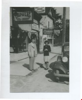
Edna and Bill Maggs
https://search.heritageburnaby.ca/link/archivedescription37082
- Repository
- City of Burnaby Archives
- Date
- 1942 (date of original), copied 1992
- Collection/Fonds
- Burnaby Historical Society fonds
- Description Level
- Item
- Physical Description
- 1 photograph : b&w ; 8.8 x 12.6 cm print
- Scope and Content
- Photograph of husband and wife, Bill and Edna Maggs, beside the Burnaby Shoe Hospital and Mr. Shewbrook's insurance office shortly after their wedding.
- Repository
- City of Burnaby Archives
- Date
- 1942 (date of original), copied 1992
- Collection/Fonds
- Burnaby Historical Society fonds
- Subseries
- Burnaby Centennial Anthology subseries
- Physical Description
- 1 photograph : b&w ; 8.8 x 12.6 cm print
- Description Level
- Item
- Record No.
- 315-545
- Access Restriction
- No restrictions
- Reproduction Restriction
- No known restrictions
- Accession Number
- BHS1994-04
- Scope and Content
- Photograph of husband and wife, Bill and Edna Maggs, beside the Burnaby Shoe Hospital and Mr. Shewbrook's insurance office shortly after their wedding.
- Names
- Maggs, Bill
- Trehearne, Edna Jean Mayhew Maggs
- Burnaby Shoe Hospital
- Shewbrooks Real Estate and Insurance
- Media Type
- Photograph
- Notes
- Title based on contents of photograph
- Geographic Access
- Kingsway
- Street Address
- 4539 Kingsway
- Historic Neighbourhood
- Central Park (Historic Neighbourhood)
- Planning Study Area
- Marlborough Area
Images

![Farmhouse and field, [194-] thumbnail](/media/hpo/_Data/_BVM_Images/2022/2022_0032_0498_001.jpg?width=280)
Farmhouse and field
https://search.heritageburnaby.ca/link/museumdescription20076
- Repository
- Burnaby Village Museum
- Date
- [194-]
- Collection/Fonds
- Esther Love Stanley fonds
- Description Level
- Item
- Physical Description
- 1 photograph : b&w ; 6.5 x 6.5 cm
- Scope and Content
- Photograph of farmhouse surrounded by field. Barn is visible in the background.
- Repository
- Burnaby Village Museum
- Collection/Fonds
- Esther Love Stanley fonds
- Description Level
- Item
- Physical Description
- 1 photograph : b&w ; 6.5 x 6.5 cm
- Scope and Content
- Photograph of farmhouse surrounded by field. Barn is visible in the background.
- Subjects
- Agriculture - Farms
- Accession Code
- BV022.32.498
- Access Restriction
- No restrictions
- Reproduction Restriction
- No known restrictions
- Date
- [194-]
- Media Type
- Photograph
- Scan Resolution
- 600
- Scan Date
- 2023-07-25
- Notes
- Title based on contents of photograph
- Photograph is part of Esther Love Stanley photograph album 2 (BV032.22.431)
Images
![Farmhouse and field, [194-] thumbnail](/media/hpo/_Data/_BVM_Images/2022/2022_0032_0498_001.jpg)
![Flooded Chan family farm, [1948] thumbnail](/media/hpo/_Data/_BVM_Images/2017/2017_0024_0023_001.jpg?width=280)
Flooded Chan family farm
https://search.heritageburnaby.ca/link/museumdescription4069
- Repository
- Burnaby Village Museum
- Date
- [1948]
- Collection/Fonds
- Julie Lee and Cecil Lee family fonds
- Description Level
- Item
- Physical Description
- 1 photograph (tiff) : sepia ; 1000 dpi
- Scope and Content
- Photograph of Suey Ying Jung (Laura) and Puy Yuen Chan in a canoe on the flooded family farm; background contains trees and two buildings; foreground contains a hedge.
- Repository
- Burnaby Village Museum
- Collection/Fonds
- Julie Lee and Cecil Lee family fonds
- Description Level
- Item
- Physical Description
- 1 photograph (tiff) : sepia ; 1000 dpi
- Scope and Content
- Photograph of Suey Ying Jung (Laura) and Puy Yuen Chan in a canoe on the flooded family farm; background contains trees and two buildings; foreground contains a hedge.
- Accession Code
- BV017.24.23
- Access Restriction
- No restrictions
- Reproduction Restriction
- No known restrictions
- Date
- [1948]
- Media Type
- Photograph
- Historic Neighbourhood
- Burnaby Lake (Historic Neighbourhood)
- Planning Study Area
- Douglas-Gilpin Area
- Scan Resolution
- 1000
- Scan Date
- 01-Oct-2017
- Scale
- 100
- Notes
- Title based on contents of photograph
Images
![Flooded Chan family farm, [1948] thumbnail](/media/hpo/_Data/_BVM_Images/2017/2017_0024_0023_001.jpg)
![Flooded Chan family farm, [1948] thumbnail](/media/hpo/_Data/_BVM_Images/2017/201700240024_001.jpg?width=280)
Flooded Chan family farm
https://search.heritageburnaby.ca/link/museumdescription4070
- Repository
- Burnaby Village Museum
- Date
- [1948]
- Collection/Fonds
- Julie Lee and Cecil Lee family fonds
- Description Level
- Item
- Physical Description
- 1 photograph (tiff) : sepia ; 1000 dpi
- Scope and Content
- Photograph of the flooded Chan family farm; buildings and telephone poles throughout the landscape.
- Repository
- Burnaby Village Museum
- Collection/Fonds
- Julie Lee and Cecil Lee family fonds
- Description Level
- Item
- Physical Description
- 1 photograph (tiff) : sepia ; 1000 dpi
- Scope and Content
- Photograph of the flooded Chan family farm; buildings and telephone poles throughout the landscape.
- Accession Code
- BV017.24.24
- Access Restriction
- No restrictions
- Reproduction Restriction
- No known restrictions
- Date
- [1948]
- Media Type
- Photograph
- Historic Neighbourhood
- Burnaby Lake (Historic Neighbourhood)
- Planning Study Area
- Douglas-Gilpin Area
- Scan Resolution
- 1000
- Scan Date
- 01-Oct-2017
- Scale
- 100
- Notes
- Title based on contents of photograph
Images
![Flooded Chan family farm, [1948] thumbnail](/media/hpo/_Data/_BVM_Images/2017/201700240024_001.jpg)
![Frank Battersby in Vernon, [1944] thumbnail](/media/hpo/_Data/_BVM_Images/2000/200401040122.jpg?width=280)
Frank Battersby in Vernon
https://search.heritageburnaby.ca/link/museumdescription1827
- Repository
- Burnaby Village Museum
- Date
- [1944]
- Collection/Fonds
- Burnaby Village Museum Photograph collection
- Description Level
- Item
- Physical Description
- 1 photograph : sepia ; 10.5 x 6 cm
- Scope and Content
- Photograph of Frank Battersby in his Seaforth Highlander uniform walking by a sign post in Vernon, British Columbia. The sign post has five arrows (pointing to the same direction) which read, "LAKE LOUISE", "MORAINE LAKE", "YOHO", "FIELD" and "GOLDEN" respectively.
- Repository
- Burnaby Village Museum
- Collection/Fonds
- Burnaby Village Museum Photograph collection
- Description Level
- Item
- Physical Description
- 1 photograph : sepia ; 10.5 x 6 cm
- Scope and Content
- Photograph of Frank Battersby in his Seaforth Highlander uniform walking by a sign post in Vernon, British Columbia. The sign post has five arrows (pointing to the same direction) which read, "LAKE LOUISE", "MORAINE LAKE", "YOHO", "FIELD" and "GOLDEN" respectively.
- Subjects
- Clothing - Military Uniforms
- Occupations - Military Personnel
- Advertising Medium - Signs and Signboards
- Names
- Battersby, Frank
- Accession Code
- BV004.104.122
- Access Restriction
- No restrictions
- Date
- [1944]
- Media Type
- Photograph
- Scan Resolution
- 600
- Scan Date
- 2/12/2010
- Scale
- 100
- Notes
- Title based on contents of photograph
- Note in black ink on verso of photograph reads: "FRANK BATTERSBY VERNON, BC"
Images
![Frank Battersby in Vernon, [1944] thumbnail](/media/hpo/_Data/_BVM_Images/2000/200401040122.jpg)
![Garage and mushroom house, [before 1969] (date of original), digitally copied 2013 thumbnail](/media/hpo/_Data/_Archives_Images/_Unrestricted/550/552-006.jpg?width=280)
Garage and mushroom house
https://search.heritageburnaby.ca/link/archivedescription77192
- Repository
- City of Burnaby Archives
- Date
- [before 1969] (date of original), digitally copied 2013
- Collection/Fonds
- Stiglish family fonds
- Description Level
- Item
- Physical Description
- 1 photograph : b&w copy-print ; 9 x 9 cm
- Scope and Content
- Photograph of the garage where Jack Stiglish repaired machinery and housed his tools, and the mushroom house beside it. A sign propped up between the two buildings reads "manure" with an arrow pointing to the right.
- Repository
- City of Burnaby Archives
- Date
- [before 1969] (date of original), digitally copied 2013
- Collection/Fonds
- Stiglish family fonds
- Physical Description
- 1 photograph : b&w copy-print ; 9 x 9 cm
- Description Level
- Item
- Record No.
- 552-006
- Access Restriction
- No restrictions
- Reproduction Restriction
- Reproduce for fair dealing purposes only
- Accession Number
- 2013-07
- Scope and Content
- Photograph of the garage where Jack Stiglish repaired machinery and housed his tools, and the mushroom house beside it. A sign propped up between the two buildings reads "manure" with an arrow pointing to the right.
- Names
- Stiglish, F.J. "Jack"
- Media Type
- Photograph
- Notes
- Title based on contents of photograph
- Note in blue ink on verso of photograph reads: "view of father's garage where his tools were + he repaired the machinery / sign saying bags of manure this way / mushroom house next to garage"
- Original spelling of surname was "Stiglich"
- Geographic Access
- Keswick Avenue
- Street Address
- 3782 Keswick Avenue
- Historic Neighbourhood
- Burquitlam (Historic Neighbourhood)
- Planning Study Area
- Cameron Area
Images
![Garage and mushroom house, [before 1969] (date of original), digitally copied 2013 thumbnail](/media/hpo/_Data/_Archives_Images/_Unrestricted/550/552-006.jpg)
![Gordon and Harry Jung with Philip Mah, [between 1935 and 1945] thumbnail](/media/hpo/_Data/_BVM_Images/2021/2021_0019_0003_001.jpg?width=280)
Gordon and Harry Jung with Philip Mah
https://search.heritageburnaby.ca/link/museumdescription16728
- Repository
- Burnaby Village Museum
- Date
- [between 1935 and 1945]
- Collection/Fonds
- Julie Lee and Cecil Lee family fonds
- Description Level
- Item
- Physical Description
- 1 photograph (jpg)
- Scope and Content
- Photograph of Suey Yook "Gordon" Jung and Suey Cheung "Harry" Jung standing with young, Philip Mah on the boardwalk outside the Jung family home located on the family farm at 5460 Douglas Road (address was changed to 5286 Douglas Road in 1958) in Burnaby. Philip Mah is the son of Lil Mah.
- Repository
- Burnaby Village Museum
- Collection/Fonds
- Julie Lee and Cecil Lee family fonds
- Description Level
- Item
- Physical Description
- 1 photograph (jpg)
- Scope and Content
- Photograph of Suey Yook "Gordon" Jung and Suey Cheung "Harry" Jung standing with young, Philip Mah on the boardwalk outside the Jung family home located on the family farm at 5460 Douglas Road (address was changed to 5286 Douglas Road in 1958) in Burnaby. Philip Mah is the son of Lil Mah.
- Geographic Access
- Vancouver
- Street Address
- 5286 Douglas Road
- Accession Code
- BV021.19.3
- Access Restriction
- No restrictions
- Reproduction Restriction
- No known restrictions
- Date
- [between 1935 and 1945]
- Media Type
- Photograph
- Historic Neighbourhood
- Burnaby Lake (Historic Neighbourhood)
- Planning Study Area
- Douglas-Gilpin Area
- Scan Resolution
- 96
- Scan Date
- April 13, 2021
- Scale
- 100
- Notes
- Title based on contents of photograph
Images
![Gordon and Harry Jung with Philip Mah, [between 1935 and 1945] thumbnail](/media/hpo/_Data/_BVM_Images/2021/2021_0019_0003_001.jpg)