Narrow Results By
Subject
- Buildings - Commercial - Hardware Stores 1
- Buildings - Residential - Houses 2
- Buildings - Schools 4
- Documentary Artifacts - Postcards 1
- Geographic Features - Parks 1
- Geographic Features - Roads 1
- Geographic Features - Trails 1
- Land Clearing 3
- Natural Phenomena - Snow 1
- Occupations - Teachers 1
- Plants - Trees 2
- Sports - Lacrosse 1

Armstrong Elementary School
https://search.heritageburnaby.ca/link/landmark762
- Repository
- Burnaby Heritage Planning
- Geographic Access
- Armstrong Avenue
- Associated Dates
- 1911
- Heritage Value
- The site for the Armstrong Avenue school was cleared in 1911. In 1955 the original structure was replaced by a new building and additions were constructed in 1962, 1964, 1967 and 1969. Armstrong Avenue was named after J.C. Armstrong, an early property owner of Burnaby who was involved in the effort to make Burnaby a municipality in 1892.
- Historic Neighbourhood
- East Burnaby (Historic Neighbourhood)
- Planning Study Area
- Cariboo-Armstrong Area
- Street Address
- 8757 Armstrong Avenue
- Street View URL
- Google Maps Street View
Images


Buena Vista Subdivision Residence
https://search.heritageburnaby.ca/link/landmark661
- Repository
- Burnaby Heritage Planning
- Description
- Residential building.
- Associated Dates
- 1911
- Street View URL
- Google Maps Street View
- Repository
- Burnaby Heritage Planning
- Geographic Access
- Armstrong Avenue
- Associated Dates
- 1911
- Description
- Residential building.
- Heritage Value
- This modest, hipped roof, cottage-style bungalow is distinguished by a full width front verandah. It was built as part of the Buena Vista subdivision in about 1911 by the Leibly & Blumer Real Estate Company. It was reported in The British Columbian in 1911: “Ten houses are now being erected by the company on the property, solid substantial five or six-room buildings that appeals to the homeseeker”. Retaining a high degree of integrity, this residence displays its original double-hung windows and lapped wooden siding. Houses of this type were often constructed from a complete package of materials offered by building supply companies, and were extremely popular due to their low cost and ease of construction.
- Locality
- East Burnaby
- Historic Neighbourhood
- East Burnaby (Historic Neighbourhood)
- Planning Study Area
- Cariboo-Armstrong Area
- Area
- 413.72
- Contributing Resource
- Building
- Ownership
- Private
- Street Address
- 8941 Armstrong Avenue
- Street View URL
- Google Maps Street View
Images


Thomas & Margaret Coldicutt Residence
https://search.heritageburnaby.ca/link/landmark647
- Repository
- Burnaby Heritage Planning
- Description
- Residential building.
- Associated Dates
- 1911
- Street View URL
- Google Maps Street View
- Repository
- Burnaby Heritage Planning
- Geographic Access
- 6th Street
- Associated Dates
- 1911
- Description
- Residential building.
- Heritage Value
- This house was built by Thomas Davis Coldicutt (1879-1970) and Margaret Jane Coldicutt, pre-eminent local citizens. Thomas Coldicutt was born in Birmingham and arrived in Canada in 1900, finding success in the steamboat industry. In 1902, he married Margaret Jane Styler who had been born in Redditch, Worcester, England, and in 1908 they settled in East Burnaby–some of the first pioneers to the area–and established a fruit farm. Thomas had a successful real estate, insurance and brokerage business, and was elected as a councillor for East Burnaby in 1909. He was also active in civic, political and social circles in Burnaby and became president of the Burnaby Board of Trade. "East Burnaby is booming and the signs of prosperity that may be seen on every hand. Most of these are substantial dwellings, such as effect a permanent improvement to the countryside. Among those whose homes have been completed, or on the point of completion may be mentioned. Councillor Coldicutt, who has built himself a habitation on Second Avenue at a cost of $4,000. (The British Columbian, 1911). In 1913, Coldicutt sold his original farm described as “the show place of Burnaby” to the Burnaby School Board for the development of Second Street School and this house was moved from Second Street and Sixteenth Avenue to this site. It has been extensively altered, but retains its original form, scale and massing.
- Locality
- East Burnaby
- Historic Neighbourhood
- East Burnaby (Historic Neighbourhood)
- Planning Study Area
- Edmonds Area
- Area
- 557.42
- Contributing Resource
- Building
- Ownership
- Private
- Street Address
- 7510 6th Street
- Street View URL
- Google Maps Street View
Images


Armstrong Avenue School
https://search.heritageburnaby.ca/link/archivedescription35043
- Repository
- City of Burnaby Archives
- Date
- 1949 (date of original), copied 1986
- Collection/Fonds
- Burnaby Historical Society fonds
- Description Level
- Item
- Physical Description
- 1 photograph : col. ; 8.8 x 12.5 cm print
- Scope and Content
- Photograph of the exterior of Armstrong Avenue School in the snow. A car is parked outside.
- Repository
- City of Burnaby Archives
- Date
- 1949 (date of original), copied 1986
- Collection/Fonds
- Burnaby Historical Society fonds
- Subseries
- Chamberlain family subseries
- Physical Description
- 1 photograph : col. ; 8.8 x 12.5 cm print
- Description Level
- Item
- Record No.
- 179-014
- Access Restriction
- No restrictions
- Reproduction Restriction
- Reproduce for fair dealing purposes only
- Accession Number
- BHS1986-27
- Scope and Content
- Photograph of the exterior of Armstrong Avenue School in the snow. A car is parked outside.
- Names
- Armstrong Avenue School
- Media Type
- Photograph
- Notes
- Title based on contents of photograph
- Print made from col. slide
- Geographic Access
- Armstrong Avenue
- Street Address
- 8757 Armstrong Avenue
- Historic Neighbourhood
- East Burnaby (Historic Neighbourhood)
- Planning Study Area
- Cariboo-Armstrong Area
Images

Armstrong Avenue School
https://search.heritageburnaby.ca/link/archivedescription37144
- Repository
- City of Burnaby Archives
- Date
- [between 1911 and 1919]
- Collection/Fonds
- Burnaby Historical Society fonds
- Description Level
- Item
- Physical Description
- 1 photograph : b&w ; 8.5 x 12.5 cm print
- Scope and Content
- Photograph of the side elevation of Armstrong Avenue School. A man is visible walking along the sidewalk, near the school.
- Repository
- City of Burnaby Archives
- Date
- [between 1911 and 1919]
- Collection/Fonds
- Burnaby Historical Society fonds
- Subseries
- Disney family subseries
- Physical Description
- 1 photograph : b&w ; 8.5 x 12.5 cm print
- Description Level
- Item
- Record No.
- 325-016
- Access Restriction
- No restrictions
- Reproduction Restriction
- No known restrictions
- Accession Number
- BHS1996-04
- Scope and Content
- Photograph of the side elevation of Armstrong Avenue School. A man is visible walking along the sidewalk, near the school.
- Subjects
- Buildings - Schools
- Names
- Armstrong Avenue School
- Media Type
- Photograph
- Photographer
- Disney, John Harold "Jack"
- Notes
- Title based on contents of photograph
- Geographic Access
- Armstrong Avenue
- Street Address
- 8757 Armstrong Avenue
- Historic Neighbourhood
- East Burnaby (Historic Neighbourhood)
- Planning Study Area
- Cariboo-Armstrong Area
Images
![Armstrong Avenue School, [between 1911 and 1919] thumbnail](/media/hpo/_Data/_Archives_Images/_Unrestricted/316/325-017.jpg?width=280)
Armstrong Avenue School
https://search.heritageburnaby.ca/link/archivedescription37145
- Repository
- City of Burnaby Archives
- Date
- [between 1911 and 1919]
- Collection/Fonds
- Burnaby Historical Society fonds
- Description Level
- Item
- Physical Description
- 1 photograph : b&w ; 8.5 x 12.5 cm print
- Scope and Content
- Photograph of the front of Armstrong Avenue School.
- Repository
- City of Burnaby Archives
- Date
- [between 1911 and 1919]
- Collection/Fonds
- Burnaby Historical Society fonds
- Subseries
- Disney family subseries
- Physical Description
- 1 photograph : b&w ; 8.5 x 12.5 cm print
- Description Level
- Item
- Record No.
- 325-017
- Access Restriction
- No restrictions
- Reproduction Restriction
- No known restrictions
- Accession Number
- BHS1996-04
- Scope and Content
- Photograph of the front of Armstrong Avenue School.
- Subjects
- Buildings - Schools
- Names
- Armstrong Avenue School
- Media Type
- Photograph
- Photographer
- Disney, John Harold "Jack"
- Notes
- Title based on contents of photograph
- Geographic Access
- Armstrong Avenue
- Street Address
- 8757 Armstrong Avenue
- Historic Neighbourhood
- East Burnaby (Historic Neighbourhood)
- Planning Study Area
- Cariboo-Armstrong Area
Images
![Armstrong Avenue School, [between 1911 and 1919] thumbnail](/media/hpo/_Data/_Archives_Images/_Unrestricted/316/325-017.jpg)
![Armstrong Avenue School, [1913] thumbnail](/media/hpo/_Data/_BVM_Images/1971/197100750001.jpg?width=280)
Armstrong Avenue School
https://search.heritageburnaby.ca/link/museumdescription26
- Repository
- Burnaby Village Museum
- Date
- [1913]
- Collection/Fonds
- Burnaby Village Museum Photograph collection
- Description Level
- Item
- Physical Description
- 1 photograph : b&w ; 11.2 x 15.8 cm mounted on cardboard 19.9 x 25.1 cm
- Scope and Content
- Photograph of school children with their teacher, who is standing to the right of the picture. An annotation on the back and an earlier catalogue record from 1971 indicates that the donor identified the photograph as the first class at Armstrong Avenue School, 1913, with Miss L. Crake as the teache…
- Repository
- Burnaby Village Museum
- Collection/Fonds
- Burnaby Village Museum Photograph collection
- Description Level
- Item
- Physical Description
- 1 photograph : b&w ; 11.2 x 15.8 cm mounted on cardboard 19.9 x 25.1 cm
- Scope and Content
- Photograph of school children with their teacher, who is standing to the right of the picture. An annotation on the back and an earlier catalogue record from 1971 indicates that the donor identified the photograph as the first class at Armstrong Avenue School, 1913, with Miss L. Crake as the teacher. However, the first two-room Armstrong Avenue School was built in 1911 with Miss Lilly Mackenzie as the teacher. The present Armstrong school was built in 1955 with eleven classrooms. Later additions to the school occurred in 1962 (two classrooms), 1964 (four classrooms), 1967 (four classrooms), and 1969 (four classrooms). Annotation in blue ballpoint pen on back of photographs reads, "1st class of Armstrong Ave School. 1913 / Miss L Crake teacher."
- History
- The first Armstrong Avenue School was built in 1911 and it consisted of two rooms. The present school was built in 1955 with 11 classrooms. Additions: 1962 - two classrooms, 1964 - four classrooms, 1967 - four classrooms.
- Subjects
- Sports - Lacrosse
- Occupations - Teachers
- Names
- Armstrong Avenue School
- Geographic Access
- Armstrong Avenue
- Street Address
- 8757 Armstrong Avenue
- Accession Code
- HV971.75.1
- Access Restriction
- No restrictions
- Reproduction Restriction
- No known restrictions
- Date
- [1913]
- Media Type
- Photograph
- Historic Neighbourhood
- East Burnaby (Historic Neighbourhood)
- Planning Study Area
- Cariboo-Armstrong Area
- Scan Resolution
- 600
- Scan Date
- 2023-03-21
- Notes
- Title based on contents of photograph
Images
![Armstrong Avenue School, [1913] thumbnail](/media/hpo/_Data/_BVM_Images/1971/197100750001.jpg)

Armstrong Avenue school site
https://search.heritageburnaby.ca/link/archivedescription34064
- Repository
- City of Burnaby Archives
- Date
- 1911
- Collection/Fonds
- Burnaby Historical Society fonds
- Description Level
- Item
- Physical Description
- 1 photograph : b&w postcard ; 6.2 x 10.4 cm
- Scope and Content
- Photographic postcard of men sawing down a tree at the Armstrong Avenue School site at 8757 Armstrong Avenue. The accompanying description refers to it as the "bee tree."
- Repository
- City of Burnaby Archives
- Date
- 1911
- Collection/Fonds
- Burnaby Historical Society fonds
- Subseries
- Photographs subseries
- Physical Description
- 1 photograph : b&w postcard ; 6.2 x 10.4 cm
- Description Level
- Item
- Record No.
- 007-001
- Access Restriction
- No restrictions
- Reproduction Restriction
- No known restrictions
- Accession Number
- BHS2007-04
- Scope and Content
- Photographic postcard of men sawing down a tree at the Armstrong Avenue School site at 8757 Armstrong Avenue. The accompanying description refers to it as the "bee tree."
- Names
- Armstrong Avenue School
- Media Type
- Photograph
- Notes
- Title based on contents of photograph
- Postcard has been cropped
- Geographic Access
- Armstrong Avenue
- Street Address
- 8757 Armstrong Avenue
- Historic Neighbourhood
- East Burnaby (Historic Neighbourhood)
- Planning Study Area
- Cariboo-Armstrong Area
Images


Armstrong Street School site
https://search.heritageburnaby.ca/link/museumdescription11133
- Repository
- Burnaby Village Museum
- Date
- 1915
- Collection/Fonds
- Ronald G. Scobbie collection
- Description Level
- Item
- Physical Description
- 1 survey plan : blueprint on paper ; 56 x 54 cm
- Scope and Content
- Survey plan of "Armstrong Street School Site / Burnaby Municipality" "Being a 2 acre portion of Lot 13 Group 1, & according to map 1722 which shows this as Lot E. Block 2 of subdivision of a portion, of Lot 13, Group 1, New Westminster District".
- Repository
- Burnaby Village Museum
- Collection/Fonds
- Ronald G. Scobbie collection
- Description Level
- Item
- Physical Description
- 1 survey plan : blueprint on paper ; 56 x 54 cm
- Material Details
- Scale 40 feet = 1 inch
- Scope and Content
- Survey plan of "Armstrong Street School Site / Burnaby Municipality" "Being a 2 acre portion of Lot 13 Group 1, & according to map 1722 which shows this as Lot E. Block 2 of subdivision of a portion, of Lot 13, Group 1, New Westminster District".
- Creator
- Burnett, Geoffrey K.
- Subjects
- Buildings - Schools
- Names
- Armstrong Avenue School
- Responsibility
- Burnett & McGugan, Engineers and Surveyors
- Geographic Access
- Armstrong Avenue
- Street Address
- 8757 Armstrong Avenue
- Accession Code
- BV003.83.12
- Access Restriction
- No restrictions
- Reproduction Restriction
- No known restrictions
- Date
- 1915
- Media Type
- Cartographic Material
- Historic Neighbourhood
- East Burnaby (Historic Neighbourhood)
- Planning Study Area
- Cariboo-Armstrong Area
- Scan Resolution
- 440
- Scan Date
- 22-Dec-2020
- Scale
- 100
- Notes
- Title based on contents of plan
- Note in black ink on verso of plan reads: "1746"
- Oath on plan reads: "I, Geoffrey K. Burnett...and did personally superintend the survey represented..." "Completed on the 18th day of March 1915"; signed by Geoffrey K. Burnett and notarized by "K.A. Eastman", sworn "...19th day of April 1915"; "Burnett and McGugan., B.C. Land Surveyors. Etc.. New Westminster, B.C.."
Zoomable Images


Coldicutt House
https://search.heritageburnaby.ca/link/archivedescription34549
- Repository
- City of Burnaby Archives
- Date
- 1914
- Collection/Fonds
- Burnaby Historical Society fonds
- Description Level
- Item
- Physical Description
- 1 photograph : b&w ; 16.0 x 21.1 cm mounted on 25.1 x 30.1 cm cardboard
- Scope and Content
- Photograph of the exterior of the Coldicutt House at 7510 6th Street.
- Repository
- City of Burnaby Archives
- Date
- 1914
- Collection/Fonds
- Burnaby Historical Society fonds
- Subseries
- Photographs subseries
- Physical Description
- 1 photograph : b&w ; 16.0 x 21.1 cm mounted on 25.1 x 30.1 cm cardboard
- Description Level
- Item
- Record No.
- 044-009
- Access Restriction
- No restrictions
- Reproduction Restriction
- No known restrictions
- Accession Number
- BHS2007-04
- Scope and Content
- Photograph of the exterior of the Coldicutt House at 7510 6th Street.
- Media Type
- Photograph
- Notes
- Title based on contents of photograph
- Geographic Access
- 6th Street
- Street Address
- 7510 6th Street
- Historic Neighbourhood
- East Burnaby (Historic Neighbourhood)
- Planning Study Area
- Second Street Area
Images


Coldicutt house
https://search.heritageburnaby.ca/link/archivedescription36575
- Repository
- City of Burnaby Archives
- Date
- 1944
- Collection/Fonds
- Burnaby Historical Society fonds
- Description Level
- Item
- Physical Description
- 1 photograph : sepia ; 7 x 5 cm
- Scope and Content
- Photograph of the front of the Coldicutt House located at 6th Street and 16th Avenue.
- Repository
- City of Burnaby Archives
- Date
- 1944
- Collection/Fonds
- Burnaby Historical Society fonds
- Subseries
- Pixie McGeachie subseries
- Physical Description
- 1 photograph : sepia ; 7 x 5 cm
- Description Level
- Item
- Record No.
- 299-001
- Access Restriction
- No restrictions
- Reproduction Restriction
- No known restrictions
- Accession Number
- BHS1992-39
- Scope and Content
- Photograph of the front of the Coldicutt House located at 6th Street and 16th Avenue.
- Subjects
- Buildings - Residential - Houses
- Media Type
- Photograph
- Notes
- Title based on contents of photograph
- Geographic Access
- 6th Street
- Street Address
- 7510 6th Street
- Historic Neighbourhood
- East Burnaby (Historic Neighbourhood)
- Planning Study Area
- Second Street Area
Images

![Lois Hollands-Coutts and Charles Hollands, [1945] (date of original), copied 1991 thumbnail](/media/hpo/_Data/_Archives_Images/_Unrestricted/370/370-429.jpg?width=280)
Lois Hollands-Coutts and Charles Hollands
https://search.heritageburnaby.ca/link/archivedescription37841
- Repository
- City of Burnaby Archives
- Date
- [1945] (date of original), copied 1991
- Collection/Fonds
- Burnaby Historical Society fonds
- Description Level
- Item
- Physical Description
- 1 photograph : b&w ; 4.1 x 2.8 cm print on contact sheet 20.6 x 26.7 cm
- Scope and Content
- Photograph of Lois Holland-Coutts and her father, Charles Hollands, on a path leading to Robert Burnaby Park, near 6th Street at 19th Avenue.
- Repository
- City of Burnaby Archives
- Date
- [1945] (date of original), copied 1991
- Collection/Fonds
- Burnaby Historical Society fonds
- Subseries
- Burnaby Image Bank subseries
- Physical Description
- 1 photograph : b&w ; 4.1 x 2.8 cm print on contact sheet 20.6 x 26.7 cm
- Description Level
- Item
- Record No.
- 370-429
- Access Restriction
- No restrictions
- Reproduction Restriction
- No known restrictions
- Accession Number
- BHS1999-03
- Scope and Content
- Photograph of Lois Holland-Coutts and her father, Charles Hollands, on a path leading to Robert Burnaby Park, near 6th Street at 19th Avenue.
- Media Type
- Photograph
- Notes
- Title based on contents of photograph
- 1 b&w copy negative accompanying
- Negative has a pink cast
- Geographic Access
- 6th Street
- 19th Avenue
- Historic Neighbourhood
- East Burnaby (Historic Neighbourhood)
- Planning Study Area
- Second Street Area
Images
![Lois Hollands-Coutts and Charles Hollands, [1945] (date of original), copied 1991 thumbnail](/media/hpo/_Data/_Archives_Images/_Unrestricted/370/370-429.jpg)
![Lot clearing for Westminster Gospel Chapel, [between 1945 and 1949] (date of original), copied 1991 thumbnail](/media/hpo/_Data/_Archives_Images/_Unrestricted/370/370-415.jpg?width=280)
Lot clearing for Westminster Gospel Chapel
https://search.heritageburnaby.ca/link/archivedescription37827
- Repository
- City of Burnaby Archives
- Date
- [between 1945 and 1949] (date of original), copied 1991
- Collection/Fonds
- Burnaby Historical Society fonds
- Description Level
- Item
- Physical Description
- 1 photograph : b&w ; 2.7 x 4.7 cm print on contact sheet 20.6 x 26.2 cm
- Scope and Content
- Photograph of people clearing a lot to build Westminster Gospel Chapel at 7540 6th Street.
- Repository
- City of Burnaby Archives
- Date
- [between 1945 and 1949] (date of original), copied 1991
- Collection/Fonds
- Burnaby Historical Society fonds
- Subseries
- Burnaby Image Bank subseries
- Physical Description
- 1 photograph : b&w ; 2.7 x 4.7 cm print on contact sheet 20.6 x 26.2 cm
- Description Level
- Item
- Record No.
- 370-415
- Access Restriction
- No restrictions
- Reproduction Restriction
- No known restrictions
- Accession Number
- BHS1999-03
- Scope and Content
- Photograph of people clearing a lot to build Westminster Gospel Chapel at 7540 6th Street.
- Subjects
- Land Clearing
- Media Type
- Photograph
- Notes
- Title based on contents of photograph
- 1 b&w copy negative accompanying
- Negative has a pink cast
- Geographic Access
- 6th Street
- Street Address
- 7540 6th Street
- Historic Neighbourhood
- East Burnaby (Historic Neighbourhood)
- Planning Study Area
- Second Street Area
Images
![Lot clearing for Westminster Gospel Chapel, [between 1945 and 1949] (date of original), copied 1991 thumbnail](/media/hpo/_Data/_Archives_Images/_Unrestricted/370/370-415.jpg)
![Lot clearing for Westminster Gospel Chapel, [between 1945 and 1949] (date of original), copied 1991 thumbnail](/media/hpo/_Data/_Archives_Images/_Unrestricted/370/370-416.jpg?width=280)
Lot clearing for Westminster Gospel Chapel
https://search.heritageburnaby.ca/link/archivedescription37828
- Repository
- City of Burnaby Archives
- Date
- [between 1945 and 1949] (date of original), copied 1991
- Collection/Fonds
- Burnaby Historical Society fonds
- Description Level
- Item
- Physical Description
- 1 photograph : b&w ; 2.6 x 4.7 cm print on contact sheet 20.6 x 26.2 cm
- Scope and Content
- Photograph of people clearing a lot to build Westminster Gospel Chapel at 7540 6th Street. Houses can be seen in the background, and the road can be seen in the foreground.
- Repository
- City of Burnaby Archives
- Date
- [between 1945 and 1949] (date of original), copied 1991
- Collection/Fonds
- Burnaby Historical Society fonds
- Subseries
- Burnaby Image Bank subseries
- Physical Description
- 1 photograph : b&w ; 2.6 x 4.7 cm print on contact sheet 20.6 x 26.2 cm
- Description Level
- Item
- Record No.
- 370-416
- Access Restriction
- No restrictions
- Reproduction Restriction
- No known restrictions
- Accession Number
- BHS1999-03
- Scope and Content
- Photograph of people clearing a lot to build Westminster Gospel Chapel at 7540 6th Street. Houses can be seen in the background, and the road can be seen in the foreground.
- Subjects
- Land Clearing
- Media Type
- Photograph
- Notes
- Title based on contents of photograph
- 1 b&w copy negative accompanying
- Negative has a pink cast
- Geographic Access
- 6th Street
- Street Address
- 7540 6th Street
- Historic Neighbourhood
- East Burnaby (Historic Neighbourhood)
- Planning Study Area
- Second Street Area
Images
![Lot clearing for Westminster Gospel Chapel, [between 1945 and 1949] (date of original), copied 1991 thumbnail](/media/hpo/_Data/_Archives_Images/_Unrestricted/370/370-416.jpg)

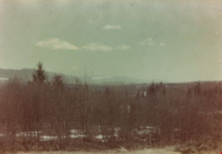
Taken from Armstrong Avenue School
https://search.heritageburnaby.ca/link/archivedescription35044
- Repository
- City of Burnaby Archives
- Date
- 1949 (date of original), copied 1986
- Collection/Fonds
- Burnaby Historical Society fonds
- Description Level
- Item
- Physical Description
- 1 photograph : col. ; 8.8 x 12.5 cm print
- Scope and Content
- Photograph taken from an Armstrong Avenue School classroom. An annotation on the back of the photograph reads, "View from the second floor of Armstrong Ave School looking North to Burnaby Lake, 1949."
- Repository
- City of Burnaby Archives
- Date
- 1949 (date of original), copied 1986
- Collection/Fonds
- Burnaby Historical Society fonds
- Subseries
- Chamberlain family subseries
- Physical Description
- 1 photograph : col. ; 8.8 x 12.5 cm print
- Description Level
- Item
- Record No.
- 179-015
- Access Restriction
- No restrictions
- Reproduction Restriction
- Reproduce for fair dealing purposes only
- Accession Number
- BHS1986-27
- Scope and Content
- Photograph taken from an Armstrong Avenue School classroom. An annotation on the back of the photograph reads, "View from the second floor of Armstrong Ave School looking North to Burnaby Lake, 1949."
- Subjects
- Plants - Trees
- Names
- Armstrong Avenue School
- Media Type
- Photograph
- Notes
- Title based on contents of photograph
- Print made from col. slide
- Geographic Access
- Armstrong Avenue
- Street Address
- 8757 Armstrong Avenue
- Historic Neighbourhood
- East Burnaby (Historic Neighbourhood)
- Planning Study Area
- Cariboo-Armstrong Area
Images
![Whitechurch Hardware building, [between 1940 and 1945] thumbnail](/media/hpo/_Data/_BVM_Images/1995/1995_0029_0001_001.jpg?width=280)
Whitechurch Hardware building
https://search.heritageburnaby.ca/link/museumdescription1250
- Repository
- Burnaby Village Museum
- Date
- [between 1940 and 1945]
- Collection/Fonds
- Burnaby Village Museum Photograph collection
- Description Level
- Item
- Physical Description
- 1 photograph : sepia ; 10.5 x 5.5 cm
- Scope and Content
- Photograph of Maurice (Maury) Whitechurch standing at the door of Whitechurch Hardware Store with his mother in-law's springer spaniel, Peggy. Whitechurch Hardware was located at 1316 Sixth Street (later, 7685 Sixth Street) and in operation between 1937 and 1973. The building formerly housed Bell's…
- Repository
- Burnaby Village Museum
- Collection/Fonds
- Burnaby Village Museum Photograph collection
- Description Level
- Item
- Physical Description
- 1 photograph : sepia ; 10.5 x 5.5 cm
- Material Details
- Border of photograph has scalloped edges
- Scope and Content
- Photograph of Maurice (Maury) Whitechurch standing at the door of Whitechurch Hardware Store with his mother in-law's springer spaniel, Peggy. Whitechurch Hardware was located at 1316 Sixth Street (later, 7685 Sixth Street) and in operation between 1937 and 1973. The building formerly housed Bell's Dry Goods store until 1937 (with address 1314 Sixth Street) when it was moved slightly north to make room for a two storey building that was built on the corner, maintaining the address of 1314 Sixth Street. In 1974, this building was relocated to Burnaby Village Museum and restored to the former Bell's Dry Goods store.
- Names
- Whitechurch Hardware
- Geographic Access
- 6th Street
- Street Address
- 7685 6th Street
- 7695 6th Street
- Accession Code
- BV995.29.1
- Access Restriction
- No restrictions
- Reproduction Restriction
- No known restrictions
- Date
- [between 1940 and 1945]
- Media Type
- Photograph
- Historic Neighbourhood
- East Burnaby (Historic Neighbourhood)
- Planning Study Area
- Second Street Area
- Scan Resolution
- 600
- Scan Date
- 2024-05-22
- Notes
- Title based on contents of photograph
- Note on verso of photograph reads: "early 1940's"
Images
![Whitechurch Hardware building, [between 1940 and 1945] thumbnail](/media/hpo/_Data/_BVM_Images/1995/1995_0029_0001_001.jpg)