Narrow Results By
Subject
- Arts 1
- Buildings - Civic - Museums 3
- Education 1
- Events 3
- Events - Festivals 1
- Events - Openings 1
- Exhibitions - Burnaby Village Museum 1
- Exhibitions - Fairs 1
- First Nations reserves - British Columbia 8
- Geographic Features - Forests 1
- Geographic Features - Lakes and Ponds 1
- Geographic Features - Parks 1
Creator
- Bartel, Mario 1
- Burnaby Village Museum 1
- Burnett, Geoffrey K. 1
- Damer, Eric 1
- Draper, William Nelson 1
- Garden, Hermon and Burwell 2
- Garden, Hermon & Burwell 1
- Gauvreau, Narcisse B. 1
- Government of Canada - Department of Mines - Geological Survey Branch 1
- Hill, Albert James 16
- Lawson, Doreen A. 1
- Smith, H. Neville 3
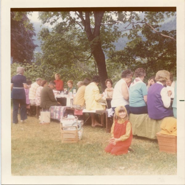
![Burnaby Village Museum Fall Fair, [1999] thumbnail](/media/hpo/_Data/_Archives_Images/_Unrestricted/535/535-3339-1.jpg?width=280)
Burnaby Village Museum Fall Fair
https://search.heritageburnaby.ca/link/archivedescription98315
- Repository
- City of Burnaby Archives
- Date
- [1999]
- Collection/Fonds
- Burnaby NewsLeader photograph collection
- Description Level
- File
- Physical Description
- 3 photographs (tiff) : col.
- Scope and Content
- File contains photographs of the Fall Fair at the Burnaby Village Museum. Photographs depict square dancers performing in front of the Museum's church; Amanda King in period costume and seated beneath a parasol; and a young child viewing two chicks in the petting zoo.
- Repository
- City of Burnaby Archives
- Date
- [1999]
- Collection/Fonds
- Burnaby NewsLeader photograph collection
- Physical Description
- 3 photographs (tiff) : col.
- Description Level
- File
- Record No.
- 535-3339
- Access Restriction
- No restrictions
- Reproduction Restriction
- No restrictions
- Accession Number
- 2018-12
- Scope and Content
- File contains photographs of the Fall Fair at the Burnaby Village Museum. Photographs depict square dancers performing in front of the Museum's church; Amanda King in period costume and seated beneath a parasol; and a young child viewing two chicks in the petting zoo.
- Subjects
- Events - Festivals
- Exhibitions - Fairs
- Exhibitions - Burnaby Village Museum
- Buildings - Civic - Museums
- Performances
- Names
- Burnaby Village Museum
- Media Type
- Photograph
- Notes
- Title based on caption
- Collected by editorial for use in a September 1999 issue of the Burnaby NewsLeader
- Caption from metadata for 535-3339-1: "Square Dancers perform on main street at Bby Village Museum's Fall Fair on the weekend"
- Caption from metadata for 535-3339-2: "Bby Village Volunteer Amanda King watches over the petting zoo in the afternoon sun."
- Caption from metadata for 535-3339-3: "Talia Tvergyak gets up close and personal with some baby chicks at the petting zoo in Burnaby Village Museum."
- Geographic Access
- Deer Lake Avenue
- Street Address
- 6501 Deer Lake Avenue
- Historic Neighbourhood
- Burnaby Lake (Historic Neighbourhood)
- Planning Study Area
- Morley-Buckingham Area
Images
![Burnaby Village Museum Fall Fair, [1999] thumbnail](/media/hpo/_Data/_Archives_Images/_Unrestricted/535/535-3339-1.jpg)
![Victoria Day at Burnaby Village Museum, [1999] thumbnail](/media/hpo/_Data/_Archives_Images/_Unrestricted/535/535-3197-1.jpg?width=280)
Victoria Day at Burnaby Village Museum
https://search.heritageburnaby.ca/link/archivedescription98118
- Repository
- City of Burnaby Archives
- Date
- [1999]
- Collection/Fonds
- Burnaby NewsLeader photograph collection
- Description Level
- File
- Physical Description
- 3 photographs (tiff) : col.
- Scope and Content
- File contains photographs of Victoria Day celebrations at Burnaby Village Museum. Photographs depict staff serving a Union Jack cake; children dancing with a maypole; and a Morris dancing performance.
- Repository
- City of Burnaby Archives
- Date
- [1999]
- Collection/Fonds
- Burnaby NewsLeader photograph collection
- Physical Description
- 3 photographs (tiff) : col.
- Description Level
- File
- Record No.
- 535-3197
- Access Restriction
- No restrictions
- Reproduction Restriction
- No restrictions
- Accession Number
- 2018-12
- Scope and Content
- File contains photographs of Victoria Day celebrations at Burnaby Village Museum. Photographs depict staff serving a Union Jack cake; children dancing with a maypole; and a Morris dancing performance.
- Names
- Burnaby Village Museum
- Media Type
- Photograph
- Notes
- Title based on contents of file
- Collected by editorial for use in a May 1999 issue of the Burnaby NewsLeader
- Geographic Access
- Deer Lake Avenue
- Street Address
- 6501 Deer Lake Avenue
- Historic Neighbourhood
- Burnaby Lake (Historic Neighbourhood)
- Planning Study Area
- Douglas-Gilpin Area
Images
![Victoria Day at Burnaby Village Museum, [1999] thumbnail](/media/hpo/_Data/_Archives_Images/_Unrestricted/535/535-3197-1.jpg)
![Interview with Shirley Cohn, [1926-2023] (interview content), interviewed 2023 thumbnail](/media/Hpo/_Data/_BVM_Sound_Recordings/Oral_Histories/2023_0016_0001_001.JPG?width=280)
Interview with Shirley Cohn
https://search.heritageburnaby.ca/link/museumdescription19597
- Repository
- Burnaby Village Museum
- Date
- [1926-2023] (interview content), interviewed 2023
- Collection/Fonds
- Burnaby Village Museum fonds
- Description Level
- File
- Physical Description
- 2 sound recordings (wav) (16 min., 57 sec.) (50 min., 36 sec.) + 1 sound recording (mp3) (50 min., 36 sec.)
- Scope and Content
- File consists of two recordings of oral history interviews with Shirley Cohn conducted by Burnaby Village Museum Registrar and Researcher, Eric Damer. The first interview was conducted on April 14, 2023 and the second interview was conducted on September 6, 2023. Summary of interview conducted on …
- Repository
- Burnaby Village Museum
- Collection/Fonds
- Burnaby Village Museum fonds
- Series
- Museum Oral Histories series
- Subseries
- Many Voices Project Interviews subseries
- Description Level
- File
- Physical Description
- 2 sound recordings (wav) (16 min., 57 sec.) (50 min., 36 sec.) + 1 sound recording (mp3) (50 min., 36 sec.)
- Material Details
- Interviewer: Eric Damer Interviewee: Shirley Cohn Location of Interviews: Burnaby Village Museum Interview Dates: April 14, 2023 and September 6, 2023 Total Number of Tracks: 2 Total Length of all Tracks: 67 min., 33 sec. Digital master recording (wav) of second interview (50 min., 36 sec.) was converted to mp3 for access on Heritage Burnaby
- Scope and Content
- File consists of two recordings of oral history interviews with Shirley Cohn conducted by Burnaby Village Museum Registrar and Researcher, Eric Damer. The first interview was conducted on April 14, 2023 and the second interview was conducted on September 6, 2023. Summary of interview conducted on September 6, 2023: 0:00 – 16:09 Shirley Cohn shares background information about her parents who immigrated to Detroit from Hungary in the 1930’s. Shirley recalls what it was like for her parents being Jewish during World War II and how many of their relations were killed in the Holocaust. Shirley talks about her Jewish Hungarian heritage, what it was like growing up in Detroit, the Jewish community in Detroit and the Jewish holidays and traditions that her family celebrated. Shirley recalls her high school and University education and experiences, starting her career in social work and how she met her future husband, Theodore “Ted” Cohn. 16:10 – 18:27 Shirley shares the story about her father in law, Dr. Daniel E. Cohn who was Harry Houdini’s doctor at the time of his death in Detroit on Oct. 31, 1926. Shirley explains that she donated some of Dr. Daniel E. Cohn’s original documents pertaining to this event to the New York Public Library. 18:28 – 26:04 Shirley describes her experiences living and working in London Ontario while her husband was a professor at University of Western Ontario and Shirley worked as a social worker in family services. Shirley recalls experiences of anti-Semitism while living in London. Shirley talks about moving to Burnaby in 1977 after her husband took a job as a professor at Simon Fraser University. Shirley describes her experiences living in Burnaby, raising a family and working as a social worker at Burnaby General Hospital. 26:05 – 26:18 Shirley talks about her interests outside of work, her family’s involvement in the Burquest Jewish Community Association and being a member of Temple Shalom. Shirley conveys information about other Jewish synagogues in Greater Vancouver, describes Reform Judaism at Temple Shalom and some Jewish cultural practices that her family has been involved with. 26:19 – 33:12 Shirley describes her family’s experiences living in the Garden Village nieghbourhood in Burnaby, her involvement sharing Jewish cultural traditions at her children’s school and recalls her children’s experiences attending school in Burnaby. 33:13 – 40:46 Shirley conveys the career paths that her children took and talks about what she likes about living in Burnaby including; the walking and hiking trails, the cultural and art performances and her involvement in local politics. Shirley talks about her and her husband’s involvement in the SFU retirees association and the SFURA walking and hiking group. Shirley reflects on her husband’s academic career, experiences teaching at SFU and the role of the Hillel Jewish Students Association at the Simon Fraser University. Shirley talks about the difficulties of discussing political views about the State of Israel. Shirley describes some traditional Jewish foods, the roles that they play and a local bakery that carries Jewish bake goods. 40:47 – 50:36 Shirley describes her current daily life in Burnaby; working one day a week as a social worker, gardening, her involvement at Temple Shalom and the Jewish Community Centre and how she travels in Burnaby. Shirley recalls the changes that she’s encountered in Burnaby and in her career over the years, shares a story about her husband losing his thesis and describes what Burnaby was like while she was raising her family. Shirley shares what she thinks about the areas of development in Burnaby and conveys the importance of having parks and affordable housing. In closing, Shirley reflects on what is like to be a Jewish person living in Burnaby.
- History
- Interviewee biography: Shirley Tanner was born in Detroit in 1947. Her parents were both Jewish. Her mother fled Hungary as a refugee in 1939, while her father emigrated from there in 1934. Shirley attended public schools in Detroit, and then studied social work at the University of Michigan. After marriage, Shirley and Ted Cohn moved to Ontario where Ted had a faculty appointment at the University of Western Ontario in political science. Six years later they moved to Burnaby for Ted’s teaching position in political science at Simon Fraser University. While living in Burnaby, Shirley took care of a growing family while also practicing social work, mainly at Burnaby Hospital. The family enjoyed Burnaby’s libraries and parks. Shirley helped out at her children’s schools, became a Block Watch captain, and the family joined Burquest Jewish Community Association. The Cohns later became members of Temple Sholom Synagogue in Vancouver, while remaining in Burnaby. Beginning in 2009, Ted started an informal hiking group for retired Simon Fraser University staff. This group has been open to others, so now has a wide variety of members. Shirley has also helped lead hikes in the region. Interviewer biography: Eric Damer is a Burnaby Village Museum Interpreter, Museum Registrar, Researcher and Blacksmith. Eric pounded hot steel for the first time in 1977 in junior high. Fifteen years later, he joined Burnaby Village Museum where he has smithed for three decades. He also provides historical research for museum exhibits and special projects. Outside the museum, Eric is a social historian with a special interest in educational history.
- Creator
- Burnaby Village Museum
- Subjects
- Education
- Recreational Activities - Hiking
- Organizations - Societies and Clubs
- Migration
- Persons - Jewish Canadians
- Religions - Judaism
- Social Issues - Racism
- Wars - World War, 1939-1945
- Names
- Cohn, Dr. Daniel E.
- Cohn, Shirley
- Cohn, Theodore H. "Ted"
- Burquest
- Hillel Jewish Students Association
- Simon Fraser University
- SFURA walking and hiking group
- Simon Fraser University Retirees Association "SFURA"
- Temple Shalom
- Responsibility
- Damer, Eric
- Accession Code
- BV023.16.1
- Access Restriction
- No restrictions
- Reproduction Restriction
- No known restrictions
- Date
- [1926-2023] (interview content), interviewed 2023
- Media Type
- Sound Recording
- Notes
- Title based on contents of file
- Summary, recording and transcript of second interview available on Heritage Burnaby
Images
![Interview with Shirley Cohn, [1926-2023] (interview content), interviewed 2023 thumbnail](/media/Hpo/_Data/_BVM_Sound_Recordings/Oral_Histories/2023_0016_0001_001.JPG)
Documents
Audio Tracks
Interview with Shirley Cohn, [1926-2023] (interview content), interviewed 2023
Interview with Shirley Cohn, [1926-2023] (interview content), interviewed 2023
https://search.heritageburnaby.ca/media/hpo/_Data/_BVM_Sound_Recordings/Oral_Histories/2023_0016_0001_003.mp3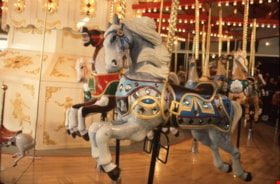
Carousel Opening
https://search.heritageburnaby.ca/link/archivedescription91712
- Repository
- City of Burnaby Archives
- Date
- March 27, 1993
- Collection/Fonds
- Doreen Lawson fonds
- Description Level
- File
- Physical Description
- 17 photographs : col. slides ; 35 mm
- Scope and Content
- File consists of photographs of the Burnaby Centennial Park Carousel grand opening on March 27, 1993 at the Burnaby Village Museum. Individuals depicted riding the carousel include City Councillor Derek Corrigan, City Manager Bob Moncur, and City staff member Denis Nokony.
- Repository
- City of Burnaby Archives
- Date
- March 27, 1993
- Collection/Fonds
- Doreen Lawson fonds
- Physical Description
- 17 photographs : col. slides ; 35 mm
- Description Level
- File
- Record No.
- 618-030
- Access Restriction
- No restrictions
- Reproduction Restriction
- No restrictions
- Accession Number
- 2015-15
- Scope and Content
- File consists of photographs of the Burnaby Centennial Park Carousel grand opening on March 27, 1993 at the Burnaby Village Museum. Individuals depicted riding the carousel include City Councillor Derek Corrigan, City Manager Bob Moncur, and City staff member Denis Nokony.
- Subjects
- Buildings - Civic - Museums
- Recreational Devices - Carousels
- Officials - Alderman and Councillors
- Names
- Burnaby Village Museum
- Media Type
- Photograph
- Photographer
- Lawson, Doreen A.
- Notes
- Transcribed title
- Title transcribed from label on slide sleeve
- Street Address
- 6501 Deer Lake Avenue
- Historic Neighbourhood
- Burnaby Lake (Historic Neighbourhood)
- Planning Study Area
- Morley-Buckingham Area
Images

![Discovery Guide '99, [1999] thumbnail](/media/hpo/_Data/_Archives_Images/_Unrestricted/535/535-3119-17.jpg?width=280)
Discovery Guide '99
https://search.heritageburnaby.ca/link/archivedescription98039
- Repository
- City of Burnaby Archives
- Date
- [1999]
- Collection/Fonds
- Burnaby NewsLeader photograph collection
- Description Level
- File
- Physical Description
- 21 photographs (tiff) : col.
- Scope and Content
- File contains photographs selected for the Burnaby NewsLeader's "Discovery Guide '99." Photographs depict: mostly unidentified people taking part in recreational activities like archery, boating, golf, fishing, hiking, and pottery at locations around Burnaby; musical and dance performances; a windo…
- Repository
- City of Burnaby Archives
- Date
- [1999]
- Collection/Fonds
- Burnaby NewsLeader photograph collection
- Physical Description
- 21 photographs (tiff) : col.
- Description Level
- File
- Record No.
- 535-3119
- Access Restriction
- No restrictions
- Reproduction Restriction
- No restrictions
- Accession Number
- 2018-12
- Scope and Content
- File contains photographs selected for the Burnaby NewsLeader's "Discovery Guide '99." Photographs depict: mostly unidentified people taking part in recreational activities like archery, boating, golf, fishing, hiking, and pottery at locations around Burnaby; musical and dance performances; a window washer on a tower; and a duck swimming on a pond.
- Subjects
- Geographic Features - Lakes and Ponds
- Geographic Features - Parks
- Recreational Activities - Golf
- Recreational Activities - Boating
- Arts
- Recreational Activities
- Sports
- Performances
- Media Type
- Photograph
- Photographer
- Bartel, Mario
- Notes
- Title based on original file name
- Collected by editorial for use an issue of the Burnaby NewsLeader
- Caption from metadata for 535-3319-8: "Kurtis Tylor, of the BC Society of Model Engineers, gives Kyle Miller, 9, a close-up look at an M420 diesel engine. Kyle was part of a group of 200 kids visiting the miniature railway at Confederation Park as part of a summer program at Hastings Park."
- Caption from metadata for 535-3319-14: "Tom Stevens, of Everett, Washington, makes sure everything is shipshape on his 1:16 scale model of a 40 ft. Alaskan trawler. He started building the model in 1962, with his dad, and he was putting it through its paces at the Burnaby Association of Marine Modellers annual regatta at the pond in Central Park."
- Geographic Access
- Central Park
- Confederation Park
- Burnaby Mountain Conservation Area
Images
![Discovery Guide '99, [1999] thumbnail](/media/hpo/_Data/_Archives_Images/_Unrestricted/535/535-3119-17.jpg)
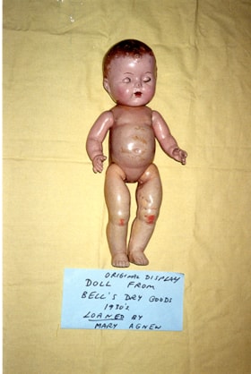
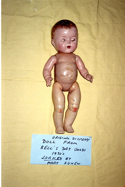
Original display doll from Bell's Dry Goods
https://search.heritageburnaby.ca/link/museumdescription16999
- Repository
- Burnaby Village Museum
- Date
- 1995
- Collection/Fonds
- Burnaby Village Museum fonds
- Description Level
- File
- Physical Description
- 14 photographs : col.negatives ; 15 x 10 cm
- Scope and Content
- File consists of fourteen photographs of an original display doll from Bell's Dry Goods store. The doll was on loan to the Burnaby Village Museum from Mary Agnew.
- Repository
- Burnaby Village Museum
- Collection/Fonds
- Burnaby Village Museum fonds
- Subseries
- Bell's exhibit photographs subseries
- Description Level
- File
- Physical Description
- 14 photographs : col.negatives ; 15 x 10 cm
- Scope and Content
- File consists of fourteen photographs of an original display doll from Bell's Dry Goods store. The doll was on loan to the Burnaby Village Museum from Mary Agnew.
- Names
- Burnaby Village Museum
- Accession Code
- BV020.5.1966
- Access Restriction
- No restrictions
- Reproduction Restriction
- No known restrictions
- Date
- 1995
- Media Type
- Photograph
- Scan Resolution
- 600
- Scan Date
- 2021-07-07
- Photographer
- Stevens, Colin
- Notes
- Title based on contents of file
- 14 photographs include numbering on verso of each in blue ink: "P95-2 to P95-10"; "P95-21 to P95-25"
- Original negatives from roll# "P95-1"
Images
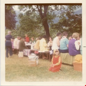
Event photographs
https://search.heritageburnaby.ca/link/archivedescription98421
- Repository
- City of Burnaby Archives
- Date
- 1973-1999
- Collection/Fonds
- Burnaby Historical Society fonds
- Description Level
- File
- Physical Description
- 267 photographs : col. ; 18 cm x 13 cm and smaller
- Scope and Content
- File contains photographs of various events, meetings, and other activities hosted by the Burnaby Historical Society as well as events and ceremonies attended by Society members.
- Repository
- City of Burnaby Archives
- Date
- 1973-1999
- Collection/Fonds
- Burnaby Historical Society fonds
- Series
- Administration series
- Physical Description
- 267 photographs : col. ; 18 cm x 13 cm and smaller
- Description Level
- File
- Record No.
- 633-003
- Access Restriction
- No restrictions
- Reproduction Restriction
- No restrictions
- Accession Number
- 2020-06
- Scope and Content
- File contains photographs of various events, meetings, and other activities hosted by the Burnaby Historical Society as well as events and ceremonies attended by Society members.
- Subjects
- Events
- Media Type
- Photograph
- Notes
- Title based on contents of file
- Photographs were originally contained in a photograph album and removed by Archives staff for preservation purposes. Original order of photographs within the album is maintained.
- Most photographs in file have handwritten notes on verso identifying the individuals and events depicted in the photographs.
- Label on sleeves housing 633-003-1:633-003-10 reads: "BHS field trip to Yale 1973"
- Identification key for 633-003-15 available in accession file
- Identification key for 633-003-22 available in accession file
- Label on sleeves housing 633-003-23:633-003-35 reads: "Christmas Party at the Home of Violet and Blythe Eagles"
- Identification key for 633-003-36 available in accession file
- 633-003-37:633-003-42 depict a presentation of the publication "Windows to Burnaby's Past"
- Labels on sleeves housing 633-003-43:633-003-50 reads: "1992 Conference BC Historical Federation / May 7, 8, 9, 1992 at Burnaby BC / Held at Sheraton Villa"
- Sticky noted adhered to verso of 633-003-54 read: 'Honorary life member Margaret Stoneberg with Past President John Spittle"
- Label on sleeves housing 633-003-59:633-003-74 reads: "Luncheon at Hart House May 7 1 pm".
- Sticky note adhered to 633-003-68 reads: "Honorary Life Member, Margaret Stoneberg - May 8, 1992"
- Sticky note adhered to 633-003-69 reads: "Lunch at Hart House - Anne Yandle and Francis Wellwood in foreground"
- Sticky note adhered to 633-003-74 reads: "Ilma Dunn (Whiterock) Nancy Peter (Burnaby) Ernest Harris (Vancouver) Naomi Miller (Wasa)"
- Label on sleeves housing 633-003-75:633-003-85 reads: "Tour of Burnaby Village Museum 2pm"
- Sticky note adhered to 633-003-78 reads: "The visitors at Burnaby Village Museum - May 8, 1992"
- Sticky note adhered to 633-003-81 reads: "History Revisited! Don Sale at the teacher's desk in Seaforth School, Burnaby Village. Don took his practice teaching in this school!"
- Label on sleeves housing 633-003-86:633-003-91 reads: "May 9th Burnaby Mountain Park"
- Label on sleeves housing 633-003-92:633-003-103 reads: "Tour of Simon Fraser University"
- Label on sleeves housing 633-003-104:633-003-109 reads: "Lunch at SFU"
- Label on sleeves housing 633-003-110:633-003-144 reads: "Awards Banquet - Burnaby Lake Pavilion"
- Sticky note adhered to 633-003-144 reads: "Four Burnaby Ladies / Joan Bellinger, Florence Hart Godwin, Helen Brown and Winn Roff relax before the Awards Banquet"
- Label on sleeves housing 633-003-145:633-003-151 reads: "Hart House Tea June 17/92"
- Label on sleeve housing 633-003-152:633-003-154 reads: "Discovery Day 1994"
- Label on sleeve housing 633-003-155:633-003-158 reads: "BHS receives first Burnaby Heritage Award 1993"
- Identification key for 633-003-155 available in accession file
- Sticky note adhered to 633-003-158 reads: "front row (l to r) Hazel L'Estrange, Mary Coe, Kay Moore / 2nd row (l to r) Una Carlson, Helen Street / 3rd row (l to r) Margaret Matorich, Pixie McGeachie"
- Label on sleeves housing 633-003-159:633-003-178 reads: "Official opening of the garden and restored Jubilee Arch Central Park 1994"
- Label on sleeves housing 633-003-180:633-003-235 reads: "Burnaby Historical Society June 25, 1997 40th Anniversary"
- Letter from the Beckleys, photographers of 633-003-236:633-003-239 available in accession file. Identification key for 633-003-237:633-003-238 available in accession file. Identification key for 633-003-239 available in accession file. Photographs depict 1989 sod turning ceremony for administration building at Burnaby Village Museum.
- Note accompanying 633-003-240 available in accession file
- Label on sleeve housing 633-003-241:633-003-242 reads: "Burnaby Discovery Day Shadbolt Centre 1998"
- Label on sleeves housing 633-003-243:633-033-246 reads: "BHS field trip to Kilby General Store and Farm June, 1998"
- Label on sleeve housing 633-003-247:633-003-249 reads: "Fraser Wilson Room Archives"
- Identification key for 633-003-252 available in accession file
- Label on sleeves housing 633-003-253:633-003-257 reads: "Heritage Award"
- Label on sleeve housing 633-003-258:633-003-261 reads: "BCHF Conference May, 1999 Merritt, B.C."
- Label on sleeve housing 633-003-262:633-003-264 reads: "Burnaby "Hero" 2002"
- 633-003-267 is annotated: "Catherine Rees 90th Birthday Party". Photo is an inkjet print on paper.
Images
![Burnaby Historical Society Christmas, [between 1999 and 2010] thumbnail](/media/Hpo/_Data/_Archives_Images/_Unrestricted/629/633-011-1.jpg?width=280)
Burnaby Historical Society Christmas
https://search.heritageburnaby.ca/link/archivedescription98456
- Repository
- City of Burnaby Archives
- Date
- [between 1999 and 2010]
- Collection/Fonds
- Burnaby Historical Society fonds
- Description Level
- File
- Physical Description
- 24 photographs : col. ; 10 cm x 15 cm
- Scope and Content
- File contains photographs from a Burnaby Historical Society Christmas party held in the ice cream parlour at the Burnaby Village Museum. The party included a performance by a group of burlesque dancers in retro costumes and visit by Santa Claus.
- Repository
- City of Burnaby Archives
- Date
- [between 1999 and 2010]
- Collection/Fonds
- Burnaby Historical Society fonds
- Series
- Administration series
- Physical Description
- 24 photographs : col. ; 10 cm x 15 cm
- Description Level
- File
- Record No.
- 633-011
- Access Restriction
- No restrictions
- Reproduction Restriction
- No restrictions
- Accession Number
- 2020-06
- Scope and Content
- File contains photographs from a Burnaby Historical Society Christmas party held in the ice cream parlour at the Burnaby Village Museum. The party included a performance by a group of burlesque dancers in retro costumes and visit by Santa Claus.
- Media Type
- Photograph
- Notes
- Title based on contents of photographs
- Photographs were originally contained in a photograph album and removed by Archives staff for preservation purposes. Original order of photographs within the album is maintained.
- Street Address
- 6501 Deer Lake Avenue
- Historic Neighbourhood
- Burnaby Lake (Historic Neighbourhood)
- Planning Study Area
- Morley-Buckingham Area
Images
![Burnaby Historical Society Christmas, [between 1999 and 2010] thumbnail](/media/Hpo/_Data/_Archives_Images/_Unrestricted/629/633-011-1.jpg)

Love family correspondence
https://search.heritageburnaby.ca/link/museumdescription10087
- Repository
- Burnaby Village Museum
- Date
- 1880-1911
- Collection/Fonds
- Love family fonds
- Description Level
- File
- Physical Description
- 1 folder of textual records
- Scope and Content
- File consists of a series of personal letters from family members in England to Jesse and Martha Love., including; Sept 22, 1880- to Jesse and Martha Love from Jesse's mother Elizabeth Love; June 7th, 1880- to Jesse from his mother Elizabeth Love; June 9th, 1880- Letter to Jesse Love from his moth…
- Repository
- Burnaby Village Museum
- Collection/Fonds
- Love family fonds
- Description Level
- File
- Physical Description
- 1 folder of textual records
- Scope and Content
- File consists of a series of personal letters from family members in England to Jesse and Martha Love., including; Sept 22, 1880- to Jesse and Martha Love from Jesse's mother Elizabeth Love; June 7th, 1880- to Jesse from his mother Elizabeth Love; June 9th, 1880- Letter to Jesse Love from his mother Elizabeth Love; April 26, 1880 - to Jesse and Martha Love from Jesse's mother Elizabeth Love; May 21, 1881 -To Jesse Love from one of his sisters regarding his mother's death; Jan 18, 1892 - Swindon - to Jesse from his sister, informing him of his father's death; 8th Jan 1906 - to Jesse from his sister,Torie Love; 28 Oct 1910 - to Martha Love from Jesse's sister Torie Love; 27th, (month?) 1910 - to Jesse Love and one of his sisters from Jesse's sister Torie; 14th July 1911 - Letter to Jesse and Martha Love from Jesse's sister Torie; an envelope - addressed to "Mr. Jesse Love / East Burnaby, New Westminster / B.C." postmarked "Jan __ 05 / SWINDON STATION" (does not appear to relate to any of the dates of the letters) and a small evelope addressed to : "Mrs Love / Burnaby".
- History
- See extensive history of Love Family and Love farmhouse located at Burnaby Village Museum.
- Accession Code
- BV012.31.19
- Access Restriction
- No restrictions
- Reproduction Restriction
- No known restrictions
- Date
- 1880-1911
- Media Type
- Textual Record
- Scan Resolution
- 300
- Scan Date
- Feb-02-2012
- Scale
- 96
- Notes
- Title based on content of file
Images

Mayor Bill Copeland
https://search.heritageburnaby.ca/link/archivedescription97391
- Repository
- City of Burnaby Archives
- Date
- 1992-2002
- Collection/Fonds
- Burnaby NewsLeader photograph collection
- Description Level
- File
- Physical Description
- 17 photographs (tiff) : b&w
- Scope and Content
- File contains photographs of or related to Mayor Bill Copeland from throughout his life and career (primarily 1992-1996) that were collected for a memorial feature. Photographs depict Copeland at Burnaby events acting as mayor at events and ceremonies, including: receiving the new city seal in 1992…
- Repository
- City of Burnaby Archives
- Date
- 1992-2002
- Collection/Fonds
- Burnaby NewsLeader photograph collection
- Physical Description
- 17 photographs (tiff) : b&w
- Description Level
- File
- Record No.
- 535-2766
- Access Restriction
- No restrictions
- Reproduction Restriction
- No restrictions
- Accession Number
- 2018-12
- Scope and Content
- File contains photographs of or related to Mayor Bill Copeland from throughout his life and career (primarily 1992-1996) that were collected for a memorial feature. Photographs depict Copeland at Burnaby events acting as mayor at events and ceremonies, including: receiving the new city seal in 1992; opening a new housing co-op on Bellwood Avenue; unveiling a plaque for Drs. Blythe and Violet Eagles in Deer Lake Park; and cutting the ribbon at the opening of the Station Square Save-On-Foods and the aftermath of the roof collapse.
- Media Type
- Photograph
- Notes
- Title based on caption
- Collected by editorial for use in a September 2002 issue of the Burnaby NewsLeader
- Caption from metadata for 535-2766-1: "Bill Copeland and former Burnaby fire chief Wayne Brassington are "arrested" at City Hall to raise money for the Cancer Society, in 1996."
- Caption from metadata for 535-2766-2: "Bill Copeland is presented with a "birthday cake" celebrating Burnaby's centennial, in 1992, by Rose Vaughan, 101."
- Caption from metadata for 535-2766-3: "Bill Copeland tries out the computer touch screen at the grand opening of the newly refurbished CW Parker Carousel, at Burnaby Village Museum in April, 1995."
- Caption from metadata for 535-2766-4: "Bill Copeland is presented with Burnaby's new city seal by former premier, Mike Harcourt, part of the city's centennial celebration, in 1992."
- Caption from metadata for 535-2766-6: "Mayor Bill and the late Rudy Spence toast Ellen Betts at a diner honoring her longtime volunteer service with the Burnaby Arts Council, in 1995."
- Caption from metadata for 535-2766-7: "Copeland is congratulated on his re-election as Mayor, in 1993."
- Caption from metadata for 535-2766-8: "Mayor Bill laces up to promote a fitness challenge at Burnaby City Hall, in 1994."
- Caption from metadata for 535-2766-9: "Mayor Bill helps work the phones to promote a Chamber of Commerce membership drive, in 1993."
- Caption from metadata for 535-2766-10: "Mayor Bill helps unveil a plaque honoring doctors Blythe and Violet Eagles, at Deer Lake Park, in 1994."
- Caption from metadata for 535-2766-11: "Mayor Bill opens a new housing co-op on Bellwood Ave., with help from Hedy Fry and former MLA, Barry Gray."
- Caption from metadata for 535-2766-12: "Mayor Bill Copeland briefs the media after the Save-On Foods collapse at Station Square."
- Caption from metadata for 535-2766-13: "Mayor Bill Copeland, Jim Pattison, and other local dignitaries, are all smiles at the official opening of the new Save-On Foods at Station Square. But shortly after the ribbon-cutting ceremony, the new store's roof collapsed."
- Caption from metadata for 535-2766-15: "Mayor Bill tries out a vegetarian plate at the City Hall cafeteria, in 1996."
- Caption from metadata for 535-2766-16: "Bill Copeland celebrates his victory in a water pistol "showdown" against rival mayor, the late Len Trabouley, from Port Coquitlam, in 1992."
- Caption from metadata for 535-2766-17: "Even after he was confined to a wheelchair, following his illness, Bill Copeland continued to attend various city functions."
Images
![Subdivision plans in New Westminster District Group 1 – Burnaby
, [1900-1910] thumbnail](/media/hpo/_Data/_BVM_Cartographic_Material/1977/1977_0093_0009a_001.jpg?width=280)
Subdivision plans in New Westminster District Group 1 – Burnaby
https://search.heritageburnaby.ca/link/museumdescription6978
- Repository
- Burnaby Village Museum
- Date
- [1900-1910]
- Collection/Fonds
- Burnaby Village Museum Map collection
- Description Level
- File
- Physical Description
- 4 plans : blueprint ink on paper mounted on 2 sides of cardboard 76 x 102 cm
- Scope and Content
- Item consists of a large board with two New Westminster District Gp 1 - subdivision plans mounted on one side and two New Westminster District Gp 1 - subdivision plans mounted on the other side. Side A: 1. Blueprint "Plan/ of Subdivisions / of portions / of / Lot 91, / Group 1 / New Westminster …
- Repository
- Burnaby Village Museum
- Collection/Fonds
- Burnaby Village Museum Map collection
- Description Level
- File
- Physical Description
- 4 plans : blueprint ink on paper mounted on 2 sides of cardboard 76 x 102 cm
- Material Details
- Scales [between 1:792 and 1:2376]
- Index number on edge of board reads: "9"
- Scope and Content
- Item consists of a large board with two New Westminster District Gp 1 - subdivision plans mounted on one side and two New Westminster District Gp 1 - subdivision plans mounted on the other side. Side A: 1. Blueprint "Plan/ of Subdivisions / of portions / of / Lot 91, / Group 1 / New Westminster Dist. / Scale 3 chs = 1 in / Map Nos 535 & 506". (Geographic location: Burnaby) 2. Blueprint "Plan / of / Subdivision of a Portion / of / Lot 28 / Group One / New Westminster Dist. / Scale 1 chs = 1 in / Map No 274". Lots are identified as "I / II / III / VI / V / IV ". The plan is bordered by First Avenue, Suburban Lands and Cemetery at the bottom, 13th Street at the top, Douglas Road to the west and 4th Street to the east. The plan is signed by "W. Thibaudeau". (Geographic location: Burnaby) Side B: 1. Blueprint "Plan / of the Subdivision of a Portion / of / Lot 29 / Group One / New Westminster District / Scale 1ch = 1 in / Map No 291 _ Subdivision 'L'". (Geographic location: Burnaby) 2. Blueprint " Plan of Subdivision / of / Lot 27 / Group One / New Westminster Dist. / Scale 3 chs = 1 in. / Map No. 697". (Geographic location: Burnaby)
- Accession Code
- HV977.93.9
- Access Restriction
- No restrictions
- Reproduction Restriction
- No known restrictions
- Date
- [1900-1910]
- Media Type
- Cartographic Material
- Scan Resolution
- 300
- Scale
- 72
- Notes
- Title based on contents of file
- Scale is measured in chains. (One chain equals 792 inches)
- The term "Lot" can also refer to a "District Lot”
Images
![Subdivision plans in New Westminster District Group 1 – Burnaby
, [1900-1910] thumbnail](/media/hpo/_Data/_BVM_Cartographic_Material/1977/1977_0093_0009a_001.jpg)

![Subdivision plans in New Westminster District Group 1 – Burnaby
, [1900-1910] thumbnail](/media/hpo/_Data/_BVM_Cartographic_Material/1977/1977_0093_0010a_001.jpg?width=280)
Subdivision plans in New Westminster District Group 1 – Burnaby
https://search.heritageburnaby.ca/link/museumdescription6979
- Repository
- Burnaby Village Museum
- Date
- [1900-1910]
- Collection/Fonds
- Burnaby Village Museum Map collection
- Description Level
- File
- Physical Description
- 4 plans : blueprint ink on paper mounted on 2 sides of cardboard 76 x 102 cm
- Scope and Content
- Item consists of a large board with two New Westminster District Gp 1 - subdivision plans mounted on one side and two New Westminster District Gp 1- subdivision plans mounted on the other side. Side A: 1. Blueprint "Plan / of Subdivision / of / Lot 15 / Group One / New Westminster District/ Sca…
- Repository
- Burnaby Village Museum
- Collection/Fonds
- Burnaby Village Museum Map collection
- Description Level
- File
- Physical Description
- 4 plans : blueprint ink on paper mounted on 2 sides of cardboard 76 x 102 cm
- Material Details
- Scales [between 1:2376 and 1:3168]
- Index number on edge of board reads: "10"
- Scope and Content
- Item consists of a large board with two New Westminster District Gp 1 - subdivision plans mounted on one side and two New Westminster District Gp 1- subdivision plans mounted on the other side. Side A: 1. Blueprint "Plan / of Subdivision / of / Lot 15 / Group One / New Westminster District/ Scale 4 chs = 1 in. / Map No 209". Subdivision plan is bordered by North Road (Lot 9) Lot 8, Lot 148 and Lot 100. (Geographic location: Burnaby) 2. Blueprint "Plan / of Subdivision / of / Lot 88 / Group 1 / Scale 4 chs = 1 in. / Map No 760". Plan is bordered by Burnaby Lake, Cumberland Street, Lot 11, Lot 25 and Lot 89. (Geographic location: Burnaby) Side B: 1. Blueprint "Plan / of the Subdivision / of / Lot "G" / in the Subdivision / of / Lot 96, Gr.1 / Scale 4 chs = 1 in. / Map No 756". Plan includes inset "Map No. 699" which includes Lots D, G, E, F, C, A and B of DL 96. Plan is bordered by False Creek Road, Westminster & Vancouver Tramway. (Geographic location: Burnaby) 2. Blueprint "Plan / of Subdivision / of South Portion / of / Lot 94, Group 1 / New Westminster District / Scale 3 chs = 1 in. / Map Nos 4402 & 720". (Geographic location: Burnaby)
- Accession Code
- HV977.93.10
- Access Restriction
- No restrictions
- Reproduction Restriction
- No known restrictions
- Date
- [1900-1910]
- Media Type
- Cartographic Material
- Scan Resolution
- 300
- Scale
- 72
- Notes
- Scale is measured in chains. (One chain equals 792 inches)
- The term "Lot" can also refer to a "District Lot”
Images
![Subdivision plans in New Westminster District Group 1 – Burnaby
, [1900-1910] thumbnail](/media/hpo/_Data/_BVM_Cartographic_Material/1977/1977_0093_0010a_001.jpg)

![Subdivision plans in New Westminster District Group 1 – Burnaby, [1905-1910] thumbnail](/media/hpo/_Data/_BVM_Cartographic_Material/1977/1977_0093_0011a_001.jpg?width=280)
Subdivision plans in New Westminster District Group 1 – Burnaby
https://search.heritageburnaby.ca/link/museumdescription6980
- Repository
- Burnaby Village Museum
- Date
- [1905-1910]
- Collection/Fonds
- Burnaby Village Museum Map collection
- Description Level
- File
- Physical Description
- 4 plans : blueprint ink on paper mounted on 2 sides of cardboard 76 x 102 cm
- Scope and Content
- Item consists of a large board of two New Westminster District Gp 1 - subdivision plans mounted on one side and two New Westminster District subdivision plans mounted on the other side. Side A: 1.Blueprint "Plan / of Subdivision / of a Portion / of / Lot 90 / Group One / New Westmisnter Distric…
- Repository
- Burnaby Village Museum
- Collection/Fonds
- Burnaby Village Museum Map collection
- Description Level
- File
- Physical Description
- 4 plans : blueprint ink on paper mounted on 2 sides of cardboard 76 x 102 cm
- Material Details
- Scales [between 1:1200 and 1:3960]
- Index number on edge of board reads: "11"
- Scope and Content
- Item consists of a large board of two New Westminster District Gp 1 - subdivision plans mounted on one side and two New Westminster District subdivision plans mounted on the other side. Side A: 1.Blueprint "Plan / of Subdivision / of a Portion / of / Lot 90 / Group One / New Westmisnter District / Scale 200 ft = 1 in. / Map No 642". (Geographic location: Burnaby) 2. Blueprint "Plan / of Subdivision / of / North Portion / of / Lot 28 / Group One / New Westminster District / Scale 100' = 1 in. / Map No 632". Geographic location: Burnaby) Side B: 1. Blueprint "Plan / of Subdivision of Lot 153 / Group 1 / New Westminster Dist. / Scale 5 chs = 1 in. / Map No. 783". Handwritten annotation in red reads: "NOTE. THIS INCLUDEDS PART / OF LOT 151. & 152". Geographic location: Burnaby) 2. Blueprint "Plan / of Subdivision of Lot 82, Group 1 / New Westminster Dist. / Scale 2 chs = 1 in. / Map No 201". Geographic location: Burnaby)
- Accession Code
- HV977.93.11
- Access Restriction
- No restrictions
- Reproduction Restriction
- No known restrictions
- Date
- [1905-1910]
- Media Type
- Cartographic Material
- Scan Resolution
- 300
- Scale
- 72
- Notes
- Title based on contents of file
- Scale is measured in chains and feet. (One chain equals 792 inches)
- The term "Lot" can also refer to a "District Lot”
Images
![Subdivision plans in New Westminster District Group 1 – Burnaby, [1905-1910] thumbnail](/media/hpo/_Data/_BVM_Cartographic_Material/1977/1977_0093_0011a_001.jpg)

![Subdivision plans in New Westminster District Group 1 – Burnaby
, [1900-1910] thumbnail](/media/hpo/_Data/_BVM_Cartographic_Material/1977/1977_0093_0012a_001.jpg?width=280)
Subdivision plans in New Westminster District Group 1 – Burnaby
https://search.heritageburnaby.ca/link/museumdescription6981
- Repository
- Burnaby Village Museum
- Date
- [1900-1910]
- Collection/Fonds
- Burnaby Village Museum Map collection
- Description Level
- File
- Physical Description
- 4 plans : blueprint ink on paper mounted on 2 sides of cardboard 76 x 102 cm
- Scope and Content
- Item consists of a large board of two New Westminster District Gp 1 - subdivision plans mounted on one side and two New Westminster District Gp 1 -subdivision plans mounted on the other side. Side A: 1. Blueprint "Plan / shewing [sic] / Subdivision of / Lot 162 / Group One / New Westmisnter Dis…
- Repository
- Burnaby Village Museum
- Collection/Fonds
- Burnaby Village Museum Map collection
- Description Level
- File
- Physical Description
- 4 plans : blueprint ink on paper mounted on 2 sides of cardboard 76 x 102 cm
- Material Details
- Scales [1:2376] and [1:3168]
- Index number on edge of board reads: "12"
- Scope and Content
- Item consists of a large board of two New Westminster District Gp 1 - subdivision plans mounted on one side and two New Westminster District Gp 1 -subdivision plans mounted on the other side. Side A: 1. Blueprint "Plan / shewing [sic] / Subdivision of / Lot 162 / Group One / New Westmisnter Dist. / Scale 4 chs = 1 in. / Map No 450". Plan is signed by "Sidney Williams / Provincial Land Surveyor" (Geographic location: Burnaby) 2. Blueprint "Plan of / Subdivision of / Block 166A / Grroup One, / Westminster District / Scale 4 chs = 1 in. / Map No 524". Plan is signed by "Sidney Williams / Provincial Land Surveyor" (Geographic location: Burnaby) Side B: 1. Blueprint "Plan / of / Subdivision of Lot 77, Group 1 / New Westminster Dist. / Scale = 4 chs = 1 in. / Map No 238" Plan is signed by "Gardue [sic] Hermon [sic] / District [sic] Land Surveyor" (Geographic location: Burnaby) 2. Blueprint " Plan / of Subdivision / of part / of / Lot 95 / Group One / New Westminster Dist. / Sclae 3 chs = 1 in. / Map No 556". (Geographic location: Burnaby)
- Creator
- Williams, Sidney
- Accession Code
- HV977.93.12
- Access Restriction
- No restrictions
- Reproduction Restriction
- No known restrictions
- Date
- [1900-1910]
- Media Type
- Cartographic Material
- Scan Resolution
- 300
- Scale
- 72
- Notes
- Title based on contents of file
- Scale is measured in chains. (One chain equals 792 inches)
- The term "Lot" can also refer to a "District Lot”
Images
![Subdivision plans in New Westminster District Group 1 – Burnaby
, [1900-1910] thumbnail](/media/hpo/_Data/_BVM_Cartographic_Material/1977/1977_0093_0012a_001.jpg)

![Subdivision plans in New Westminster District Group 1 – Burnaby
, [1882-1910] thumbnail](/media/hpo/_Data/_BVM_Cartographic_Material/1977/1977_0093_0013a_001.jpg?width=280)
Subdivision plans in New Westminster District Group 1 – Burnaby
https://search.heritageburnaby.ca/link/museumdescription6982
- Repository
- Burnaby Village Museum
- Date
- [1882-1910]
- Collection/Fonds
- Burnaby Village Museum Map collection
- Description Level
- File
- Physical Description
- 4 plans : blueprint on paper mounted on 2 sides of cardboard 76 x 102 cm
- Scope and Content
- Item consists of a large board of two New Westminster District Gp 1 - subdivision plans mounted on one side and two New Westminster District Gp 1 - subdivision plans mounted on the other side. Side A: 1. Blueprint "Plan / of the / Subdivision / of / Lot 98 / G.1, N.W.D. / Scale 4 chs = 1 in. / …
- Repository
- Burnaby Village Museum
- Collection/Fonds
- Burnaby Village Museum Map collection
- Description Level
- File
- Physical Description
- 4 plans : blueprint on paper mounted on 2 sides of cardboard 76 x 102 cm
- Material Details
- Scales [between 1:1584 and 1:3168]
- Index number on edge of board reads: "13"
- Scope and Content
- Item consists of a large board of two New Westminster District Gp 1 - subdivision plans mounted on one side and two New Westminster District Gp 1 - subdivision plans mounted on the other side. Side A: 1. Blueprint "Plan / of the / Subdivision / of / Lot 98 / G.1, N.W.D. / Scale 4 chs = 1 in. / Map No 573" (Geographic location: Burnaby) 2. Blueprint "Plan / of Subdivision of / Lot 157 / Gr.1, New. West. Dist. / Scale 3 chs = 1 in. / Map No. 612". (Geographic location: Burnaby) Side B: 1. Blueprint "Plan / of Subdivision / of a Portion of / Lot 90 / Group One / New Westminster Dist. / Scale 2 chs = 1 in. / Map No. 555". Plan is signed by "Jno Strathern [sic]_P.L.S."n (Geographic location: Burnaby) 2. Blueprint "Subdivision of Lot 31, Group 1. / New Westminster District / As Amended by Order of Court / 1st Sept. 1882 and Numbered 847 / Scale 4 chs = 1in. / Map No 80" (Geographic location: Burnaby)
- Creator
- Stathern, John
- Accession Code
- HV977.93.13
- Access Restriction
- No restrictions
- Reproduction Restriction
- No known restrictions
- Date
- [1882-1910]
- Media Type
- Cartographic Material
- Historic Neighbourhood
- Alta Vista (Historic Neighbourhood)
- Planning Study Area
- Richmond Park Area
- Lakeview-Mayfield Area
- Scan Resolution
- 300
- Scale
- 72
- Notes
- Title based on contents of file
- Scale is measured in chains. (One chain equals 792 inches)
- The term "Lot" can also refer to a "District Lot”
Images
![Subdivision plans in New Westminster District Group 1 – Burnaby
, [1882-1910] thumbnail](/media/hpo/_Data/_BVM_Cartographic_Material/1977/1977_0093_0013a_001.jpg)

![Subdivision plans in New Westminster District Group 1 – Burnaby
, [1890-1910] thumbnail](/media/hpo/_Data/_BVM_Cartographic_Material/1977/1977_0093_0014a_001.jpg?width=280)
Subdivision plans in New Westminster District Group 1 – Burnaby
https://search.heritageburnaby.ca/link/museumdescription6983
- Repository
- Burnaby Village Museum
- Date
- [1890-1910]
- Collection/Fonds
- Burnaby Village Museum Map collection
- Description Level
- File
- Physical Description
- 4 plans : blueprint ink on paper mounted on 2 sides of cardboard 76 x 102 cm
- Scope and Content
- Item consists of a large board of two New Westminster District Gp 1 - subdivision plans mounted on one side and two New Westminster District Gp 1 - subdivision plans mounted on the other side. Side A: 1. Blueprint "Plan of / Subdivision of Lot No. 69 / Group One / New Westminster District / Pro…
- Repository
- Burnaby Village Museum
- Collection/Fonds
- Burnaby Village Museum Map collection
- Description Level
- File
- Physical Description
- 4 plans : blueprint ink on paper mounted on 2 sides of cardboard 76 x 102 cm
- Material Details
- Scales [between 1:1584 and 1:3168]
- Index number on edge of board reads: "14"
- Scope and Content
- Item consists of a large board of two New Westminster District Gp 1 - subdivision plans mounted on one side and two New Westminster District Gp 1 - subdivision plans mounted on the other side. Side A: 1. Blueprint "Plan of / Subdivision of Lot No. 69 / Group One / New Westminster District / Property of Ernest Buse, Esq. / Scale 3 chs = 1 in. / Map No 290". Plan is signed by "Garden, Hermon and Burwell, Dom. Land Surveyor" (Geographic location: Burnaby) 2. Blueprint "Plan / of Subdivision / of Lots 1-19, 36-53 and 69-75 inclusive / in the Subdivision / of / Lot 30 / Group One / New Westminster District / Scale 2 chs = 1 in. Map No 631". Plan is signed by "Jno [sic] Strathern [sic] P.L.S." Names and Lot numbers are handwritten in red pencil in sections along Douglas Road and read: "20 - F / 21 - Fitherstruhaul [sic] / 22 - J.S. Craig / 23 - McGill & Dill / 24 / 25 / 26 / 27 / 28 - School / 29 - School / 30 - D. McDownall / 31 - W.J. Troloow [sic] / 32 - N.C. Nelson / 33 - _[sic] McGill / 34 - T.S.[sic] Craig / 35" (Geographic location: Burnaby) Side B: 1.Blueprint "Plan / of Subdivision / of Centre Portion / of Lot 28 / Group One / New Westminster District / Scale 200' = 1" / Map No 627". Plan is signed by "Jno Strathern / P.L.S." (Geographic location: Burnaby) 2. Blueprint "Plan / of Subdivision / of N.1/2 Lot 100 and S.1/2 Lot 101, / Group One / New Westminster District, BC / Scale 4 chs = 1 in." (Geographic location: Burnaby)
- Names
- Strathern, John
- Accession Code
- HV977.93.14
- Access Restriction
- No restrictions
- Reproduction Restriction
- No known restrictions
- Date
- [1890-1910]
- Media Type
- Cartographic Material
- Historic Neighbourhood
- Broadview (Historic Neighbourhood)
- East Burnaby (Historic Neighbourhood)
- Planning Study Area
- Cascade-Schou Area
- West Central Valley Area
- Second Street Area
- Lake City Area
- Scan Resolution
- 300
- Scale
- 72
- Notes
- Title based on contents of file
- Scale is measured in chains and feet. (One chain equals 792 inches)
- The term "Lot" can also refer to a "District Lot”
Images
![Subdivision plans in New Westminster District Group 1 – Burnaby
, [1890-1910] thumbnail](/media/hpo/_Data/_BVM_Cartographic_Material/1977/1977_0093_0014a_001.jpg)

![Subdivision plans in New Westminster District Group 1 – Burnaby
, [1891-1910] thumbnail](/media/hpo/_Data/_BVM_Cartographic_Material/1977/1977_0093_0015a_001.jpg?width=280)
Subdivision plans in New Westminster District Group 1 – Burnaby
https://search.heritageburnaby.ca/link/museumdescription6984
- Repository
- Burnaby Village Museum
- Date
- [1891-1910]
- Collection/Fonds
- Burnaby Village Museum Map collection
- Description Level
- File
- Physical Description
- 4 plans : blueprint ink on paper mounted on 2 sides of cardboard 76 x 102 cm
- Scope and Content
- Item consists of a large board of two New Westminster District Gp 1 - subdivision plans mounted on one side and two New Westminster District Gp 1 - subdivision plans mounted on the other side. Side A: 1. Blueprint "Plan / of Subdivision / of / Lot 29 / Group One / New Westminster District / Scal…
- Repository
- Burnaby Village Museum
- Collection/Fonds
- Burnaby Village Museum Map collection
- Description Level
- File
- Physical Description
- 4 plans : blueprint ink on paper mounted on 2 sides of cardboard 76 x 102 cm
- Material Details
- Scales [between 1:600 and 1:7920]
- Index number on edge of board reads: "15"
- Scope and Content
- Item consists of a large board of two New Westminster District Gp 1 - subdivision plans mounted on one side and two New Westminster District Gp 1 - subdivision plans mounted on the other side. Side A: 1. Blueprint "Plan / of Subdivision / of / Lot 29 / Group One / New Westminster District / Scale 4 chs = 1 in. / Map No 564, Depostd '91". "Reichenbach", dep. Aug. 1891. (Geographic location: Burnaby) 2. Blueprint "Plan / of Subdivision / of / Lot 93 / Group One / New Westminster District / Scale 4 chs = 1 in. / Map No 284". (Geographic location: Burnaby) Side B: 1. Blueprint "Plan / of Subdivision / of a Portion / of / [Lot A of ] Lot 29 / Group One / New Westminster District / Scale 50 ' = 1"" Plan is bordered by Douglas Road to the east, False Creek Trail to the south and Lot 30 to the north. (Geographic location: Burnaby) 2. Blueprint "Plan / of Central Park / and Vicinity / Scale 10 chs = 1 in." (Geographic location: Burnaby)
- Accession Code
- HV977.93.15
- Access Restriction
- No restrictions
- Reproduction Restriction
- No known restrictions
- Date
- [1891-1910]
- Media Type
- Cartographic Material
- Historic Neighbourhood
- Edmonds (Historic Neighbourhood)
- Planning Study Area
- Edmonds Area
- Scan Resolution
- 300
- Scale
- 72
- Notes
- Title based on contents of file
- Scale is measured in chains and feet. (One chain equals 792 inches)
- The term "Lot" can also refer to a "District Lot”
Images
![Subdivision plans in New Westminster District Group 1 – Burnaby
, [1891-1910] thumbnail](/media/hpo/_Data/_BVM_Cartographic_Material/1977/1977_0093_0015a_001.jpg)

![Subdivision plans in New Westminster District Group 1 – Burnaby
, [1893-1910] thumbnail](/media/hpo/_Data/_BVM_Cartographic_Material/1977/1977_0093_0016a_001.jpg?width=280)
Subdivision plans in New Westminster District Group 1 – Burnaby
https://search.heritageburnaby.ca/link/museumdescription6985
- Repository
- Burnaby Village Museum
- Date
- [1893-1910]
- Collection/Fonds
- Burnaby Village Museum Map collection
- Description Level
- File
- Physical Description
- 4 plans : blueprint ink on paper mounted on 2 sides of cardboard 76 x 102 cm
- Scope and Content
- Item consists of a large board of two New Westminster District Gp 1 - subdivision plans mounted on one side and two New Westminster District Gp 1 - subdivision plans mounted on the other side. Side A: 1. Blueprint "Plan / of Subdivision / of / Lot 6 / Group One / New Westminster District / Scale…
- Repository
- Burnaby Village Museum
- Collection/Fonds
- Burnaby Village Museum Map collection
- Description Level
- File
- Physical Description
- 4 plans : blueprint ink on paper mounted on 2 sides of cardboard 76 x 102 cm
- Material Details
- Scales [between 1:1584 and 1:3960]
- Index number on edge of board reads: "16"
- Scope and Content
- Item consists of a large board of two New Westminster District Gp 1 - subdivision plans mounted on one side and two New Westminster District Gp 1 - subdivision plans mounted on the other side. Side A: 1. Blueprint "Plan / of Subdivision / of / Lot 6 / Group One / New Westminster District / Scale 5 chs = 1 in. / Map No 748" (Geographic location: Burnaby) 2. Blueprint "Plan / of Subdivision / of a Portion / of / Lot 29 / Group One / New Westminster Dist. / Scale 2 chs = 1 in. / Map No." Name identified in Block H is "Reichenbach" (Geographic location: Burnaby) Side B: 1. Blueprint "Plan / of Subdivision / of North 1/2 of Lot 80 / Group One / New Westminster District / Scale 3 chs = 1 in. / Map No 719" Plan is signed by: "Garden, Hermon & Burwell P.L.S. / Vancouver Jan. 23rd, 1893" (Geographic location: Burnaby) 2. Blueprint "Plan / of Subdivision / of Lot 79, Gr.1 / New Westminster Dist. / Scale 4 chas = 1 in. / Map No 536" Plan is signed by "Garden Hermon & Burwell / Provincial Land Surveyors". (Geographic location: Burnaby)
- Creator
- Garden, Hermon and Burwell
- Accession Code
- HV977.93.16
- Access Restriction
- No restrictions
- Reproduction Restriction
- No known restrictions
- Date
- [1893-1910]
- Media Type
- Cartographic Material
- Historic Neighbourhood
- Edmonds (Historic Neighbourhood)
- Burnaby Lake (Historic Neighbourhood)
- Planning Study Area
- Douglas-Gilpin Area
- Edmonds Area
- Cameron Area
- Scan Resolution
- 300
- Scale
- 72
- Notes
- Title based on contents of file
- Scale is measured in chains. (One chain equals 792 inches)
- The term "Lot" can also refer to a "District Lot”
Images
![Subdivision plans in New Westminster District Group 1 – Burnaby
, [1893-1910] thumbnail](/media/hpo/_Data/_BVM_Cartographic_Material/1977/1977_0093_0016a_001.jpg)


Subdivision plans in New Westminster District Group 1 – Burnaby, Vancouver and map - Canada Department of Mines
https://search.heritageburnaby.ca/link/museumdescription6994
- Repository
- Burnaby Village Museum
- Date
- 1890-1909
- Collection/Fonds
- Burnaby Village Museum Map collection
- Description Level
- File
- Physical Description
- 1 plan : graphite on paper + 2 plans : black ink on paper + 1 map : col. on paper mounted on 2 sides of cardboard 76 x 102 cm
- Scope and Content
- Item consists of a large board with one New Westminster District subdivision plan mounted on one side and two New Westminster District subdivision plans and one colour map mounted on the other side. Side A: 1. "Plan / of Subdivision of / Blocks 2, 3, 4, 5, 6 / Lot 77 / Group 1 / New Westminster D…
- Repository
- Burnaby Village Museum
- Collection/Fonds
- Burnaby Village Museum Map collection
- Description Level
- File
- Physical Description
- 1 plan : graphite on paper + 2 plans : black ink on paper + 1 map : col. on paper mounted on 2 sides of cardboard 76 x 102 cm
- Material Details
- Scales 1:720 and 1:1200 and 1:.00001578
- Scope and Content
- Item consists of a large board with one New Westminster District subdivision plan mounted on one side and two New Westminster District subdivision plans and one colour map mounted on the other side. Side A: 1. "Plan / of Subdivision of / Blocks 2, 3, 4, 5, 6 / Lot 77 / Group 1 / New Westminster District / BC. / Scale 100 feet = 1 inch", "Deposited 8th day / of April 1890 / Mowileg [sic] / Dist. Regt". Plan is drawn in graphite with annotations: "AB_Parts_lettered_are_lots_in / the_different_subdivisions" / "Owners: / James E. Hall / P.S.Cabilan [sic] by his attorney Joseph Hall / Joseph Hall / Eliza J. Shannon / John Harrison"; "This plan is correct and is prepared under the / provisions of the Land Registry Act" ; signed by: "Gordon Herman & Burwell / Dominion & Provincial Land Surveryors / Vancouver March 19th/90" . Plan is initialed by: "RB" [sic] (in blue pencil crayon) and measures: 99.5 x 65 cm (Geographic location: Burnaby) Side B: 1. Map titled "Canada / Department of Mines / Geological Survey Branch" / "Hon.W Templeton, Minister / A.P. Low, Deputy Minister / R.W. Brock, Acting Director", Vol. XXXI, Plate I / Compiled under the direction of / James White, F.R.G.S. Geographer /Dep. of Interior". Note above map reads: "To illustrate Mr. James Barrowman's report as Delegate at the Excursion - meeting of the Canadian Mining Institute", "The instiitution of Mining Engineers / Transactions 1908 - 1909", "The Mining Institute of Scotland / Transactions 1908-1909". Map identifies minerals and includes a Legend and Scale: 100 miles = 1 inch 2. "Plan / of Subdivision of / Lot 4 / of Subdivision of / Lot 87. Gr. 1 / New Westminster District / Scale 60' = 1in." Plan is initialed by: "RB" [sic] along with a note "also Board / 48" (in blue pencil crayon) (Geographic location: Burnaby) 3. Plan of "Lot 335 / G. 1" west of Boundary Road and north of River Road - Vancouver. (Geographic location: Vancouver)
- Publisher
- The Mining Institute of Scotland
- Geographic Access
- Vancouver
- Accession Code
- HV977.93.25
- Access Restriction
- No restrictions
- Reproduction Restriction
- No known restrictions
- Date
- 1890-1909
- Media Type
- Cartographic Material
- Scan Resolution
- 300
- Scale
- 72
- Notes
- Title based on contents of file
- Scale is measured in feet and miles.
- The term "Lot" often refers to "District Lot"
Images


![Survey and Subdivision plans in New Westminster District Group 1 - Burnaby
, [1906-1910] thumbnail](/media/hpo/_Data/_BVM_Cartographic_Material/1977/1977_0093_0001a_001.jpg?width=280)
Survey and Subdivision plans in New Westminster District Group 1 - Burnaby
https://search.heritageburnaby.ca/link/museumdescription6970
- Repository
- Burnaby Village Museum
- Date
- [1906-1910]
- Collection/Fonds
- Burnaby Village Museum Map collection
- Description Level
- File
- Physical Description
- 7 plans : blueprint ink on paper + 2 plans : black ink on paper mounted on 2 sides of cardboard 76 cm x 102 cm
- Scope and Content
- Item consists of a large board of six New Westminster District Gp 1 subdivision plans mounted on one side and three New Westminster District Gp 1 subdivision plans mounted on the other side with scales ranging from one chain equals one inch to four chains equals one inch. Side A: 1. Blueprint "Pl…
- Repository
- Burnaby Village Museum
- Collection/Fonds
- Burnaby Village Museum Map collection
- Description Level
- File
- Physical Description
- 7 plans : blueprint ink on paper + 2 plans : black ink on paper mounted on 2 sides of cardboard 76 cm x 102 cm
- Material Details
- Scales [1:792] and [1:3168]
- Index number on edge of board reads: "1"
- Scope and Content
- Item consists of a large board of six New Westminster District Gp 1 subdivision plans mounted on one side and three New Westminster District Gp 1 subdivision plans mounted on the other side with scales ranging from one chain equals one inch to four chains equals one inch. Side A: 1. Blueprint "Plan / of Subdivision / of a portion / of / Lot 13, GR.1 / New Westminster District". Plan is bordered by Cumberland Street, Tenth Ave., Cariboo Street, Armstrong Street, "See Bd.145", Map No891 (Geographic location: Burnaby) 2."Plan / of Subdivision / of a portion / of / Lot 13, GR.1 / New Westminster District". Plan is bordered by Cumberland Street, Tenth Ave., Cariboo St. and Armstrong St. Pencilled annotations on plan read: "for Subdivisions see Board 145"; "Subdivided by H. Neville Smith". (Geographic location: Burnaby) 3. Blueprint "Plan / of Subdivision / of a part / of / Lot 155 / Group 1 / New Westminster District". Plan is bordered by North Arm of Fraser, Wiggins Rd. and Lot 173. Plan created by "NB Gauvreau" (Geographic location: Burnaby) Side B: 1. Blueprint plan which reads: "Albert J. Hill / P.L.S." at top with handwritten annotation: "Lot 85". The plan is bordered by Hastings Rd. and Burnaby Lake with names on lots identified as:"Laura Troop; Jas. Anderson and A. de W. Haszard". (Geographic location: Burnaby) 2. Blueprint plan which reads: "Albert J. Hill / P.L.S" at top with handwritten annotation: "Lot 85". The plan is bordered by Hastings Rd. and Burnaby Lake with names on lots identified as:"Laura Troop; A. de W. Haszard". (Geographic location: Burnaby) 3.Plan of "Survey of Road / for / Burnaby Council". "Albert J. Hill, M.A. Civil Engineer". Plan identifies "Centre Line Lot 10 / Present Road" at the centre and is bordered by Gunn Rd. at the top and Brunette River at the bottom. (Geographic location: Burnaby) 4.Blueprint "Plan / of Subdivision / Lot 97 Group 1/ N.W.D." Plan is bordered by Lots 93, 94 and 96 and Webster Road. Vancouver and New Westminster Road crosses the upper right corner of the plan and the New Westminster Vancouver Tramway runs through from Power House Rd. to Webster Road. Lower right corner identifies "W.N. Draper, P.LotS." (Geographic location: Burnaby) 5. Blueprint "Plan / of / The Subdivision of / Portion of / Lot 85, GP.1 / New Westminster District" Plan is bordered by Lots 79 / Byrne Drive; Burnaby Lake/ Esplanade and Lot 87. Plan is identified with "Albert J. Hill / B.C.LotS. / 19/6/09" (Geographic location: Burnaby) 6. Blueprint "Plan / of Subdivision/ of / Lot 155B, Group One / New Westminster District". Plan is bordered by Lots 155A, 155C, 162 / Byrne Road, 166A / Wiggins Road with Spruce Street running through the middle and Westminster- Eburne Ry. Right of Way running diagonally. Plan is identified with "Albert J. Hill (Geographic location: Burnaby)
- Accession Code
- HV977.93.1
- Access Restriction
- No restrictions
- Reproduction Restriction
- No known restrictions
- Date
- [1906-1910]
- Media Type
- Cartographic Material
- Scan Resolution
- 300
- Scan Date
- 2019-07-16
- Scale
- 72
- Notes
- Title based on contents of file
- Stamp on plans reads: "ALBERT J. HILL M.A. / CIVIL ENGINEER / and / PROVINCIAL LAND SURVEYOR / NEW WESTMINSTER / BC"
- Scale is measured in chains. (One chain equals 792 inches)
Images
![Survey and Subdivision plans in New Westminster District Group 1 - Burnaby
, [1906-1910] thumbnail](/media/hpo/_Data/_BVM_Cartographic_Material/1977/1977_0093_0001a_001.jpg)
