Narrow Results By
Subject
- Agriculture - Farms 1
- Arts - Paintings 1
- Buildings - Commercial - Grocery Stores 1
- Buildings - Commercial - Restaurants 1
- Buildings - Commercial - Service Stations 1
- Buildings - Industrial - Saw Mills 1
- Buildings - Schools 10
- Businesses - Real Estate Agencies 1
- Clothing 1
- Crafts 1
- Education 4
- Employment 1
Creator
- Aitkenhead, May 1
- Bekins Moving and Storage Company Limited 1
- Burnaby Village Museum 7
- Burnett and McGugan B.C. Land Surveyors, New Westminster 5
- Burnett, Geoffrey K. 1
- Burnett & McGugan, Engineers and Surveyors 5
- City Map and White Print Co. 1
- Damer, Eric 2
- Fong, Denise 2
- Geoffrey K. Burnett 1
- Hawkshaw, Mabel Edith Honor McClean 1
- Hill & Burnett 2

2nd Burnaby Troop Boy Scouts album
https://search.heritageburnaby.ca/link/museumdescription19612
- Repository
- Burnaby Village Museum
- Date
- 1913-1925, predominant 1923-1925
- Collection/Fonds
- David Geoffrey Llewellyn collection
- Description Level
- File
- Physical Description
- 1 album (151 photographs + ephemera + textual records)
- Scope and Content
- File consists of a sixty page photograph album titled "2nd Burnaby Troop Boy Scouts" with photographs and ephemera pasted onto fourty one pages. The album includes photographs of the Burnaby Boy Scouts at various events, camps and hikes, the Burnaby Girl Guides and May Day events in Burnaby and New…
- Repository
- Burnaby Village Museum
- Collection/Fonds
- David Geoffrey Llewellyn collection
- Description Level
- File
- Physical Description
- 1 album (151 photographs + ephemera + textual records)
- Material Details
- 41 pages of album have pasted content
- 19 pages at the back of the album are blank
- Scope and Content
- File consists of a sixty page photograph album titled "2nd Burnaby Troop Boy Scouts" with photographs and ephemera pasted onto fourty one pages. The album includes photographs of the Burnaby Boy Scouts at various events, camps and hikes, the Burnaby Girl Guides and May Day events in Burnaby and New Westminster.
- Subjects
- Organizations - Boys' Societies and Clubs
- Events - May Day
- Organizations - Girls' Societies and Clubs
- Accession Code
- BV995.8.1
- Access Restriction
- No restrictions
- Reproduction Restriction
- No known restrictions
- Date
- 1913-1925, predominant 1923-1925
- Media Type
- Photograph
- Textual Record
- Scan Resolution
- 600
- Scan Date
- 2023-07-20
- Notes
- Transcribed title from cover of photograph album
- Sticker on lower left of back cover reads, "No. D", "Glendale Album", "Made in Canada by Canadian Kodak Co., Limited. Toronto"
- Individual photographs + ephemera within album are numbered BV995.8.2 to BV995.8.153 - item level descriptions available
Images

Documents
![50th Anniversary G.G.C., [1926-1979] thumbnail](/media/hpo/_Data/_BVM_Images/2015/2015_0035_0166_folded_redacted.jpg?width=280)
50th Anniversary G.G.C.
https://search.heritageburnaby.ca/link/museumdescription4594
- Repository
- Burnaby Village Museum
- Date
- [1926-1979]
- Collection/Fonds
- Burnaby Girl Guides fonds
- Description Level
- File
- Physical Description
- 1 scrapbook (51 photographs + 1 postcard + textual records)
- Scope and Content
- File consists of a scrapbook with a handpainted wood cover titled "50th Anniversary / G.G.C". The scrapbook documents events and ceremonies of the 4th Guide Company with the first half of the scrapbook containing photographs and documents regarding the 50th Anniversary of Girl Guides which was cele…
- Repository
- Burnaby Village Museum
- Collection/Fonds
- Burnaby Girl Guides fonds
- Description Level
- File
- Physical Description
- 1 scrapbook (51 photographs + 1 postcard + textual records)
- Scope and Content
- File consists of a scrapbook with a handpainted wood cover titled "50th Anniversary / G.G.C". The scrapbook documents events and ceremonies of the 4th Guide Company with the first half of the scrapbook containing photographs and documents regarding the 50th Anniversary of Girl Guides which was celebrated at St. Nicholas Church in 1960 while the second half documents earlier events from 1926, as well as other events in the 1960s such as; "Year of the Golden Jubilee", a parade in North Burnaby as well as Thinking Day 1976-1978, banquets, a disco contest, camping on Hollyburn mountain and a visit to Victoria in 1979. On November 3rd, 1926 the company was registered as the 5th Burnaby Guide company, in 1951 the number was changed to the 4th Vancouver Guide Company and in 1956 the number was changed to the 4th Burnaby Company.
- Accession Code
- BV015.35.166
- Access Restriction
- No restrictions
- Reproduction Restriction
- May be restricted by third party rights
- Date
- [1926-1979]
- Media Type
- Textual Record
- Photograph
- Notes
- Transcribed title
- Items within scrapbook have been redacted in compliance with Section 22 of FIPPA
- A selection of photographs are described at item level (BV015.35.285 to BV.015.35.300).
Images
![50th Anniversary G.G.C., [1926-1979] thumbnail](/media/hpo/_Data/_BVM_Images/2015/2015_0035_0166_folded_redacted.jpg)
Documents

Alice Hart photograph album
https://search.heritageburnaby.ca/link/museumdescription14366
- Repository
- Burnaby Village Museum
- Date
- 1893-1923 (date of original), copied 1976
- Collection/Fonds
- Florence Hart Godwin fonds
- Description Level
- File
- Physical Description
- 1 album (31 photographs: b&w negatives ; 35 mm)
- Scope and Content
- File consists of a photographic reproduction of a twenty nine page photograph album that was created by Alice Hart. Inscription inside of front cover reads "To dearest Alice from father 30th March 1906". The album is filled with photographs of the Hart family along with friends and relations. The p…
- Repository
- Burnaby Village Museum
- Collection/Fonds
- Florence Hart Godwin fonds
- Description Level
- File
- Physical Description
- 1 album (31 photographs: b&w negatives ; 35 mm)
- Scope and Content
- File consists of a photographic reproduction of a twenty nine page photograph album that was created by Alice Hart. Inscription inside of front cover reads "To dearest Alice from father 30th March 1906". The album is filled with photographs of the Hart family along with friends and relations. The photographs range between 1893 and 1923 and document time spent at residences in New Westminster, Deer Lake and Kerrisdale along with family vacations at Mayne Island, Stanely Park and Pitt Lake.
- Accession Code
- HV976.169.1
- Access Restriction
- No restrictions
- Reproduction Restriction
- No known restrictions
- Date
- 1893-1923 (date of original), copied 1976
- Media Type
- Photograph
- Textual Record
- Scan Date
- 10/27/2020
- Notes
- Title based on contents of photograph album
- Inscription on first page of album reads: "To dearest Alice / from father / 30th March, 1906”.
- 31 b&w copy prints accompanying
- Album pages are described at item level
Images

Documents

Armstrong Street School site
https://search.heritageburnaby.ca/link/museumdescription11133
- Repository
- Burnaby Village Museum
- Date
- 1915
- Collection/Fonds
- Ronald G. Scobbie collection
- Description Level
- Item
- Physical Description
- 1 survey plan : blueprint on paper ; 56 x 54 cm
- Scope and Content
- Survey plan of "Armstrong Street School Site / Burnaby Municipality" "Being a 2 acre portion of Lot 13 Group 1, & according to map 1722 which shows this as Lot E. Block 2 of subdivision of a portion, of Lot 13, Group 1, New Westminster District".
- Repository
- Burnaby Village Museum
- Collection/Fonds
- Ronald G. Scobbie collection
- Description Level
- Item
- Physical Description
- 1 survey plan : blueprint on paper ; 56 x 54 cm
- Material Details
- Scale 40 feet = 1 inch
- Scope and Content
- Survey plan of "Armstrong Street School Site / Burnaby Municipality" "Being a 2 acre portion of Lot 13 Group 1, & according to map 1722 which shows this as Lot E. Block 2 of subdivision of a portion, of Lot 13, Group 1, New Westminster District".
- Creator
- Burnett, Geoffrey K.
- Subjects
- Buildings - Schools
- Names
- Armstrong Avenue School
- Responsibility
- Burnett & McGugan, Engineers and Surveyors
- Geographic Access
- Armstrong Avenue
- Street Address
- 8757 Armstrong Avenue
- Accession Code
- BV003.83.12
- Access Restriction
- No restrictions
- Reproduction Restriction
- No known restrictions
- Date
- 1915
- Media Type
- Cartographic Material
- Historic Neighbourhood
- East Burnaby (Historic Neighbourhood)
- Planning Study Area
- Cariboo-Armstrong Area
- Scan Resolution
- 440
- Scan Date
- 22-Dec-2020
- Scale
- 100
- Notes
- Title based on contents of plan
- Note in black ink on verso of plan reads: "1746"
- Oath on plan reads: "I, Geoffrey K. Burnett...and did personally superintend the survey represented..." "Completed on the 18th day of March 1915"; signed by Geoffrey K. Burnett and notarized by "K.A. Eastman", sworn "...19th day of April 1915"; "Burnett and McGugan., B.C. Land Surveyors. Etc.. New Westminster, B.C.."
Zoomable Images


Barnet School site
https://search.heritageburnaby.ca/link/museumdescription11140
- Repository
- Burnaby Village Museum
- Date
- May 27, 1915
- Collection/Fonds
- Ronald G. Scobbie collection
- Description Level
- Item
- Physical Description
- 1 survey plan : blueprint on paper ; 56 x 54 cm
- Scope and Content
- Survey plan of "Barnet School Site / Burnaby Municipality" "Being a portion of the west half of lot / 214, Group 1 / New Westminster District”.
- Repository
- Burnaby Village Museum
- Collection/Fonds
- Ronald G. Scobbie collection
- Description Level
- Item
- Physical Description
- 1 survey plan : blueprint on paper ; 56 x 54 cm
- Material Details
- Scale 40 feet = 1 inch
- Scope and Content
- Survey plan of "Barnet School Site / Burnaby Municipality" "Being a portion of the west half of lot / 214, Group 1 / New Westminster District”.
- Creator
- McGugan, Donald Johnston
- Subjects
- Buildings - Schools
- Names
- Barnet School
- Responsibility
- Burnett & McGugan, Engineers and Surveyors
- Geographic Access
- Barnet Road
- Street Address
- 7820 Barnet Road
- Accession Code
- BV003.83.19
- Access Restriction
- No restrictions
- Reproduction Restriction
- No known restrictions
- Date
- May 27, 1915
- Media Type
- Cartographic Material
- Historic Neighbourhood
- Barnet (Historic Neighbourhood)
- Planning Study Area
- Burnaby Mountain Area
- Scan Resolution
- 440
- Scan Date
- 22-Dec-2020
- Scale
- 100
- Notes
- Title based on contents of plan
- handwritten on back "Burnaby Schools" "23R" twice, "1783"
- Oath on plan reads: "I, D.J. McGugan...and did personally superintend the survey..." "completed on the 27th day of May 1915"; signed by D.J. McGugan, notarized by "Walter Edmonds" "sworn "...29th day of May 1915" "Burnett and McGugan" "B.C. Land Surveyors Etc. New Westminster, B.C.";
Zoomable Images


B.C. Girl Guides
https://search.heritageburnaby.ca/link/museumdescription5234
- Repository
- Burnaby Village Museum
- Date
- 1914 -1982 (date of original), copied 2016
- Collection/Fonds
- Burnaby Girl Guides fonds
- Description Level
- File
- Physical Description
- 1 scrapbook (2 digital files (pdfs) + 39 photographs (tiffs)
- Scope and Content
- File consists of images of a scrapbook of newspaper clippings, photographs and memorabilia pertaining to guiding in Burnaby between 1930 and 1981. The scrapbook includes a photograph of the 1st Burnaby Girl Guide Company in 1914 and The Girl Guides Conference from 1950. This scrapbook was often us…
- Repository
- Burnaby Village Museum
- Collection/Fonds
- Burnaby Girl Guides fonds
- Description Level
- File
- Physical Description
- 1 scrapbook (2 digital files (pdfs) + 39 photographs (tiffs)
- Scope and Content
- File consists of images of a scrapbook of newspaper clippings, photographs and memorabilia pertaining to guiding in Burnaby between 1930 and 1981. The scrapbook includes a photograph of the 1st Burnaby Girl Guide Company in 1914 and The Girl Guides Conference from 1950. This scrapbook was often used by Paulene Hall at presentations.
- Creator
- Walker, Bea
- Names
- Girl Guides of Canada
- Accession Code
- BV016.49.83
- Access Restriction
- No restrictions
- Reproduction Restriction
- May be restricted by third party rights
- Date
- 1914 -1982 (date of original), copied 2016
- Media Type
- Photograph
- Textual Record
- Notes
- Title based on content of scrapbook
- Selective retention of original records from scrapbook
- Selected photographs were retained and described at item level : BV016.49.126 & BV016.49.96
Images

Documents
![Bird's eye view of New Westminster, Burnaby and Vancouver, [ca. 1911] thumbnail](/media/hpo/_Data/_BVM_Cartographic_Material/1983/1983_0012_0001_002%20Web.jpg?width=280)
Bird's eye view of New Westminster, Burnaby and Vancouver
https://search.heritageburnaby.ca/link/museumdescription8199
- Repository
- Burnaby Village Museum
- Date
- [ca. 1911]
- Collection/Fonds
- Burnaby Village Museum Map collection
- Description Level
- Item
- Physical Description
- 1 map : hand painted ; 65.5 x 99 cm
- Scope and Content
- An untitled monochromatic grayscale map of a developer's bird's eye view looking north west from Burnaby Mountain. View includes Burnaby, New Westminster, Vancouver with the North shore in the distance. Burnaby neighbourhood subdivisions of "Burnaby Heights" and "Buena Vista" are featured near the…
- Repository
- Burnaby Village Museum
- Collection/Fonds
- Burnaby Village Museum Map collection
- Description Level
- Item
- Physical Description
- 1 map : hand painted ; 65.5 x 99 cm
- Scope and Content
- An untitled monochromatic grayscale map of a developer's bird's eye view looking north west from Burnaby Mountain. View includes Burnaby, New Westminster, Vancouver with the North shore in the distance. Burnaby neighbourhood subdivisions of "Burnaby Heights" and "Buena Vista" are featured near the centre of the map. These neighbourhood subdivisions were marketed by Real Estate Agents Liebly & Blumer in 1911. Roads, buildings, factories, railways and bridges are identified on the map.
- Subjects
- Businesses - Real Estate Agencies
- Responsibility
- Leibly & Blumer Realty Co. Incorporated
- Accession Code
- HV983.12.1
- Access Restriction
- No restrictions
- Reproduction Restriction
- No known restrictions
- Date
- [ca. 1911]
- Media Type
- Cartographic Material
- Historic Neighbourhood
- East Burnaby (Historic Neighbourhood)
- Vancouver Heights (Historic Neighbourhood)
- Planning Study Area
- Cariboo-Armstrong Area
- Burnaby Heights Area
- Scan Resolution
- 300
- Scan Date
- December 2020
- Scale
- 100
- Notes
- Title based on contents of map
- Note in pencil on verso of photograph reads: "Make tint block of Buena Vista / Blocks only as shown in lots"
Zoomable Images
![Bird's eye view of New Westminster, Burnaby and Vancouver, [ca. 1911] thumbnail](/media/hpo/_Data/_BVM_Cartographic_Material/1983/1983_0012_0001_001_seadragon/1983_0012_0001_001.jpg?w=280)
![Burnaby Girl Guides, [1914]-1969, predominant ca. 1920 (date of original), copied 2016 thumbnail](/media/hpo/_Data/_BVM_Images/2015/2015_0035_0164_folded.jpg?width=280)
Burnaby Girl Guides
https://search.heritageburnaby.ca/link/museumdescription4592
- Repository
- Burnaby Village Museum
- Date
- [1914]-1969, predominant ca. 1920 (date of original), copied 2016
- Collection/Fonds
- Burnaby Girl Guides fonds
- Description Level
- File
- Physical Description
- 1 scrapbook (textual records + 2 digital files : (pdfs) + 102 photographs : (tiffs))
- Scope and Content
- File consists of images and selected contents from a scrapbook with 38 double sided pages containing mostly photographs with some newspaper clippings, written material and emphemera including a page of badges and ribbons which reads "Enrolment & Membership Card of / Joan Bailey 1926 / 1st Burnaby" …
- Repository
- Burnaby Village Museum
- Collection/Fonds
- Burnaby Girl Guides fonds
- Description Level
- File
- Physical Description
- 1 scrapbook (textual records + 2 digital files : (pdfs) + 102 photographs : (tiffs))
- Scope and Content
- File consists of images and selected contents from a scrapbook with 38 double sided pages containing mostly photographs with some newspaper clippings, written material and emphemera including a page of badges and ribbons which reads "Enrolment & Membership Card of / Joan Bailey 1926 / 1st Burnaby" and an embroidered alphabet of the Morse Code. The third page of the scrapbook includes a four page chronology titled "History of Guiding - Burnaby / 1913 - 1960" compiled by Mrs. Dolly Weber, Mrs. J. Heaps, Miss Eileen Periton, Mrs. J. Albertson and D. Fowler. The scrapbook also includes an original letter and post-script from Lady Olave Baden-Powell to Mrs. Fowler dated November 5, 1961; a typewritten copy of: "TSOONA" / PROVINCIAL GUIDE CAMPSITE - ROSEDALE B.C." and a three page typewritten copy of "THE CAMPFIRE / Volume 1, No. 4 _ November 1935 _ Vancouver, B.C.". Many of the events documented in photographs [between 1914 and 1969] are identified on each page and read as the following: "Burnaby Brownies - Guides & Rangers" / "Early 1920" (1 photograph); "Ambulance / Display / 1st. Co."; "Girl Guide Rally - New Westminster and / Burnaby - June 16, 1923" (5 photographs); "Girl Guide Rally - New Westminster and / Burnaby - June 16, 1923" (5 photographs); "Burnaby Guides and / Brownies / June 17, 1923" (5 photographs); "April 1923" (1 photograph); "June 1923 / 2nd Burnaby Company" (1 photograph); "Burnaby May Day / 26.5.28"(2 photographs); "Sechelt 1929_ 2nd "B" Company" (2 photographs); "Leaders and Seconds / 2nd Burnaby / Grouse Mountain" (1 photograph); "Sechelt 1929 / Commandant Mrs. Peal" (1 photograph); "2nd Company / June 1930" (1 photograph); "1932 / 2nd Company at Rally / Municipal Hall Grounds" (1 photograph) ; "First Burnaby Folk Dancing team / Winners of the E.F.D. cup 1940--41-42" (1 photograph); "1st Burnaby Company / winners of Bessborough Shield / 1942 / Captain L. Crane" (1 photograph); "May 6th 1935 / Dedication of flag at Central Park" (1 photograph); "May Day Celebration / Burnaby B.C. May 6th 1935 / Stride Studios Photos" (1 photograph); "Mrs. Don Wilks / Mrs. Georgie / Runcie / Publicity Photo re- / Brownie / Training / 1958-60" (1 photograph); "Kathleen Anderson / about 1958-60?" (1 photograph); "1957 / Burnaby Camp Site / at / Wilson Creek" (1 photograph); "Work Party (1958)" (1 photograph); "Burnaby Camp Site / Spring 1958 / Cabins & Staff Houses / Dining Shelter / Cabins" (3 photographs); "Can. Girl Guide Assoc. - Provincial Leaders Conference / April 14-15/61 Civic Centre, Prince George, BC" (1 photograph) ; "June 8th, 1958 / Opening / Ceremonies / Burnaby Site / Wilson Creek / Camp Site" (4 photographs); 2 unidentified photographs [ca.1915] of a large group of Girl Guides gathered on the Pacific National Exhibition grounds (photo credit- Leonard Frank); 1 unidentified photograph of a group of Girl Guides gathered for a group portrait [ca.1914]; "Girl Guide Camp / Granthams / Landing / July 1923" (4 photographs); 4 unidentified photographs of girl guides gathered on the ship "Lady Evelyn" [ca. 1920]; "Burnaby Girl Guides" 1918; "First Burnaby Girl Guides 1920" (2 photographs on page); "2nd Co. 1923" (1 photograph) "1st Burnaby Co." [1923] (1 photograph); "Gypsy Scene - Concert / Mar 17, 1923 / Unveiling / War / Memorial / Edmonds / 1923" (3 photographs on page); "Faith Jacobson / 1961" (2 photographs); "Eve MacLean / 1961" (1 photograph); "Beverley Simkin of Montreal and Judy Robins / of the S.R.S. Royal Oak taken on the day they / sailed from Montreal for the Ranger Camp at / "Our Chalet" in Adelboden, Switzerland, May 1962" (1 photograph) and "Religion & Life Emblem / Diane Peters 11th Bby. Co. / Rev. G.W. Luetkehodeter / 1961" (2 photographs on one page).
- Names
- Girl Guides of Canada
- Accession Code
- BV015.35.164
- Access Restriction
- No restrictions
- Reproduction Restriction
- May be restricted by third party rights
- Date
- [1914]-1969, predominant ca. 1920 (date of original), copied 2016
- Media Type
- Photograph
- Textual Record
- Historic Neighbourhood
- Edmonds (Historic Neighbourhood)
- Central Park (Historic Neighbourhood)
- Planning Study Area
- Edmonds Area
- Maywood Area
- Notes
- Transcribed title
- Digital images were created of the scrapbook prior to selective retention of original records that were removed for conservation purposes
- Some textual records that were selected for retention have been described at file level under BV015.35.164: "Tsoona" Provincial Guide Campsite - Rosedale B.C." and Burnaby Girl Guides newsletter, "The Campfire" (November 1935)
- Photographs that were retained from scrapbook have been described at item level (BV015.35.221 to BV015.35.284)
- Some textual records and ephemera that were selected for retention have been described at item level (BV015.35.320, BV015.35.321, and BV015.35.334 to BV015.35.348).
Images
![Burnaby Girl Guides, [1914]-1969, predominant ca. 1920 (date of original), copied 2016 thumbnail](/media/hpo/_Data/_BVM_Images/2015/2015_0035_0164_folded.jpg)
Documents

Edmonds Street School site
https://search.heritageburnaby.ca/link/museumdescription11125
- Repository
- Burnaby Village Museum
- Date
- March 8, 1915
- Collection/Fonds
- Ronald G. Scobbie collection
- Description Level
- Item
- Physical Description
- 1 survey plan : blueprint on paper ; 56 x 54 cm
- Scope and Content
- Survey plan of "Edmonds Street School Site" "Burnaby Municipality" "Being Lots 28 and 29 of the Subdivision of Lot 30, Group 1, New Westminster District";
- Repository
- Burnaby Village Museum
- Collection/Fonds
- Ronald G. Scobbie collection
- Description Level
- Item
- Physical Description
- 1 survey plan : blueprint on paper ; 56 x 54 cm
- Material Details
- Scale: 4 feet = 1 inch
- Scope and Content
- Survey plan of "Edmonds Street School Site" "Burnaby Municipality" "Being Lots 28 and 29 of the Subdivision of Lot 30, Group 1, New Westminster District";
- Subjects
- Buildings - Schools
- Names
- Edmonds Community School
- Responsibility
- Burnett and McGugan B.C. Land Surveyors, New Westminster
- Geographic Access
- Edmonds Street
- Street Address
- 7641 Edmonds Street
- Accession Code
- BV003.83.5
- Access Restriction
- No restrictions
- Reproduction Restriction
- No known restrictions
- Date
- March 8, 1915
- Media Type
- Cartographic Material
- Historic Neighbourhood
- Edmonds (Historic Neighbourhood)
- Planning Study Area
- Edmonds Area
- Scan Resolution
- 440
- Scan Date
- 22-Dec-2020
- Scale
- 100
- Notes
- Title based on contents of plan
- Oath in bottom left corner reads: "I, D.J. McGugan...and did personally superintend the survey..." "...completed on the 8th day of March 1915"; signed "D.J. McGugan", notarized by "S.F. Mark" "sworn...12th Day of April 1915"
- handwritten on back, "1756"
Zoomable Images

![Esther Love Stanley photograph album 1, [1900-1928] thumbnail](/media/hpo/_Data/_BVM_Images/2022/2022_0032_0001_003.jpg?width=280)
Esther Love Stanley photograph album 1
https://search.heritageburnaby.ca/link/museumdescription19284
- Repository
- Burnaby Village Museum
- Date
- [1900-1928]
- Collection/Fonds
- Esther Love Stanley fonds
- Description Level
- File
- Physical Description
- 1 photograph album (429 photographs)
- Scope and Content
- Photograph album consists of photographs of various members of the Love family, relatives, friends and descendants including the members of the Brandrith, Stanley, Whiting and MacKenzie families. Album includes photographs taken by family members as well as portrait photographers that document even…
- Repository
- Burnaby Village Museum
- Collection/Fonds
- Esther Love Stanley fonds
- Description Level
- File
- Physical Description
- 1 photograph album (429 photographs)
- Scope and Content
- Photograph album consists of photographs of various members of the Love family, relatives, friends and descendants including the members of the Brandrith, Stanley, Whiting and MacKenzie families. Album includes photographs taken by family members as well as portrait photographers that document events, celebrations, gatherings, travels throughout British Columbia, various residences and vacation homes. Album and annotations were created by Esther Love Stanley and descendants.
- Creator
- Stanley, Esther Love
- Accession Code
- BV022.32.1
- Access Restriction
- No restrictions
- Reproduction Restriction
- No known restrictions
- Date
- [1900-1928]
- Media Type
- Photograph
- Notes
- Title based on contents of album
- Individual photographs within album are described at item level BV022.32.2 to BV022.32.430
- Duplicate photographs within album were not accessioned or described
Images
![Esther Love Stanley photograph album 1, [1900-1928] thumbnail](/media/hpo/_Data/_BVM_Images/2022/2022_0032_0001_003.jpg)
Documents

Family and political photograph album
https://search.heritageburnaby.ca/link/museumdescription3654
- Repository
- Burnaby Village Museum
- Date
- 1914-1977
- Collection/Fonds
- Harold Edward Winch collection
- Description Level
- Item
- Physical Description
- 1 album (ca. 85 photographs)
- Scope and Content
- Item is a photograph album containing ca. 85 photographs, including both personal and work-related subjects such as the Winch family and homes, and Winch's political work and travels. Also included are some textual records relating to Winch's political work.
- Repository
- Burnaby Village Museum
- Collection/Fonds
- Harold Edward Winch collection
- Description Level
- Item
- Physical Description
- 1 album (ca. 85 photographs)
- Scope and Content
- Item is a photograph album containing ca. 85 photographs, including both personal and work-related subjects such as the Winch family and homes, and Winch's political work and travels. Also included are some textual records relating to Winch's political work.
- Names
- Winch, Harold Edward
- Winch, Linda Marian Hendy
- Winch, Grace
- Winch, Eileen
- Winch, Ernest "Ernie"
- Winch, Eric
- Co-operative Commonwealth Federation "CCF"
- New Democratic Party
- Douglas, Tommy
- MacInnis, Grace
- Accession Code
- BV013.12.11
- Date
- 1914-1977
- Media Type
- Photograph
- Textual Record
- Notes
- Title based on contents of photograph
- A selection of photographs from scrapbook have been described at item level (BV013.12.36 to BV015.35.117)
Images

Documents

First Burnaby Company
https://search.heritageburnaby.ca/link/museumdescription4590
- Repository
- Burnaby Village Museum
- Date
- 1934-1939
- Collection/Fonds
- Burnaby Girl Guides fonds
- Description Level
- File
- Physical Description
- 1 scrapbook (2 photographs + illustrations + textual records)
- Scope and Content
- File consists of a scrapbook with sixteeen double sided pages with handwritten journal notations, poems, hand drawn illustrations and photographs documenting 1st Burnaby Girl Guide activities including meetings, hiking, camping and various outings. Many of the journal entries describe hiking around…
- Repository
- Burnaby Village Museum
- Collection/Fonds
- Burnaby Girl Guides fonds
- Description Level
- File
- Physical Description
- 1 scrapbook (2 photographs + illustrations + textual records)
- Scope and Content
- File consists of a scrapbook with sixteeen double sided pages with handwritten journal notations, poems, hand drawn illustrations and photographs documenting 1st Burnaby Girl Guide activities including meetings, hiking, camping and various outings. Many of the journal entries describe hiking around Burnaby including areas such as Deer Lake, Brunette River, Willingdon and the Gilley Avenue Ravine while photographs document a garden party at the Municipal Hall at Edmonds in 1936. Photograph BV015.35.162.1 is titled "Garden Party / 1936" with Brown Owls identified L to R as: Mrs. Gowan, Miss May Dumas and Miss Kay Crossfield. Photograph BV015.35.162.2 is titled " Folk-dancing team / 1936 / Garden Party, Municipal Hall, Edmonds" with people identified in the top row L to R as: Phyllis Lockhart, Margaret Wilson, Marion Bellinger, Betty Martin and Peggy Urquhart and bottom row L to R as: Joan Warburton, Kay Lambert and Joan Mortimer. The scrapbook may have been a collective project by Marion Bellinger, Jean Atcheson, Margaret Wilson and Connie Benning.
- Names
- Atcheson, Jean
- Wilson, Margaret
- Bellinger, Marion
- Dumas, May
- Crossfield, Kay
- Lockhart, Phyllis
- Martin, Betty
- Urquhart, Peggy
- Warburton, Joan
- Lambert, Kay
- Mortimer, Joan
- Girl Guides of Canada
- Accession Code
- BV015.35.162
- Access Restriction
- No restrictions
- Reproduction Restriction
- May be restricted by third party rights
- Date
- 1934-1939
- Media Type
- Photograph
- Textual Record
- Graphic Material
- Notes
- Title based on contents of scrapbook
- Two photographs are described at item level (BV015.35.162.1 & BV015.35.162.2)
Images

Documents

Florence Hart Godwin photograph album
https://search.heritageburnaby.ca/link/museumdescription3049
- Repository
- Burnaby Village Museum
- Date
- 1893-1923 (date of original), copied 1976
- Collection/Fonds
- Florence Hart Godwin fonds
- Description Level
- File
- Physical Description
- 1 album (29 photographs: b&w negatives ; 35 mm)
- Scope and Content
- File consists of a photographic reproduction of a twenty nine page photograph album that was created by Florence Hart Godwin. The first page of the album reads "Florence, with Grandma's and Auntie Felicia's best love, Xmas 1910" and the other pages contain photographs. The album was given to Flore…
- Repository
- Burnaby Village Museum
- Collection/Fonds
- Florence Hart Godwin fonds
- Description Level
- File
- Physical Description
- 1 album (29 photographs: b&w negatives ; 35 mm)
- Scope and Content
- File consists of a photographic reproduction of a twenty nine page photograph album that was created by Florence Hart Godwin. The first page of the album reads "Florence, with Grandma's and Auntie Felicia's best love, Xmas 1910" and the other pages contain photographs. The album was given to Florence Hart for Christmas in 1910, by her grandmother Jane Chapman (nee Isbell) and her Aunt Felicia Chapman. Album contains photographs of the Alice and Frederick J. Hart and Chapman families, including childhood photographs of the five Hart children, Kingsley, Florence, Fredricka, Edwyna and Jack; the Hart family at their home in New Westminster and at "Avalon" their summer residence and home on Deer Lake.
- Names
- Godwin, Florence Hart
- Accession Code
- HV976.168.1
- Access Restriction
- No restrictions
- Reproduction Restriction
- No known restrictions
- Date
- 1893-1923 (date of original), copied 1976
- Media Type
- Photograph
- Textual Record
- Scan Resolution
- 600
- Scan Date
- 2023-07-24
- Notes
- Title based on contents of photograph album
- 29 b&w copy prints accompanying
- Item level descriptions available per album page
Images

Documents

Gilmour Avenue School site
https://search.heritageburnaby.ca/link/museumdescription11129
- Repository
- Burnaby Village Museum
- Date
- May 27, 1915
- Collection/Fonds
- Ronald G. Scobbie collection
- Description Level
- Item
- Physical Description
- 1 survey plan : blueprint on paper ; 56 x 54 cm
- Scope and Content
- Survey plan of Gilmore Avenue School site. Title on plan reads: "Gilmour Avenue School Site / Burnaby Municipality / Being Lots 1-10 inc. & Lots 27-36 inc. of Block 9 / of Subdivision of a Portion of Lot 187, GP.1 / New Westminster District". "Note. School site is as shown below, the original...am…
- Repository
- Burnaby Village Museum
- Collection/Fonds
- Ronald G. Scobbie collection
- Description Level
- Item
- Physical Description
- 1 survey plan : blueprint on paper ; 56 x 54 cm
- Material Details
- Scale: 40 feet = 1 inch
- Scope and Content
- Survey plan of Gilmore Avenue School site. Title on plan reads: "Gilmour Avenue School Site / Burnaby Municipality / Being Lots 1-10 inc. & Lots 27-36 inc. of Block 9 / of Subdivision of a Portion of Lot 187, GP.1 / New Westminster District". "Note. School site is as shown below, the original...amended" "by cancelling Lots 1-10 & 27-30 inc....order of court filed No.4938".
- History
- The school was named after Hugh B. Gilmour, but an error by a municipal clerk in the Street Naming Bylaw in 1912 (Bylaw Number 135) changed the spelling to "Gilmore" Avenue and the school name was spelled "Gilmore" Avenue School hereafter.
- Creator
- McGugan, Donald Johnston
- Subjects
- Buildings - Schools
- Names
- Gilmore Avenue School
- Responsibility
- Burnett & McGugan, Engineers and Surveyors
- Geographic Access
- Gilmore Avenue
- Accession Code
- BV003.83.8
- Access Restriction
- No restrictions
- Reproduction Restriction
- No known restrictions
- Date
- May 27, 1915
- Media Type
- Cartographic Material
- Historic Neighbourhood
- Vancouver Heights (Historic Neighbourhood)
- Planning Study Area
- Willingdon Heights Area
- Scan Resolution
- 440
- Scan Date
- 22-Dec-2020
- Scale
- 100
- Notes
- Transcribed title taken from plan
- Oath in bottom left corner reads: "I, D.J. McGugan...did superintend the survey", "...completed on the 27th day of May 1915" and noterized by Walter Edmonds" "sworn...29th Day of May 1915"; "Burnett and McGugan. B.C. Land Surveyors Etc. New Westminster. B.C."
- Note in black ink on verso of plan reads: "1782"
Zoomable Images

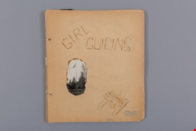
Girl Guiding
https://search.heritageburnaby.ca/link/museumdescription4588
- Repository
- Burnaby Village Museum
- Date
- 1939-1951
- Collection/Fonds
- Burnaby Girl Guides fonds
- Description Level
- File
- Physical Description
- 1 scrapbook album (99 photographs+ textual records + other material)
- Scope and Content
- File consists of 18 loose pages of a scrapbook created by Ivy McGeachie (nee Ivy Oldham) who was involved in guiding in Burnaby between 1942 -1948. The front page of the scrapbook is titled “Girl / Guiding” and has a wood-burnt image of a camp fire and a singed photo of a flag pole. The scrapbook …
- Repository
- Burnaby Village Museum
- Collection/Fonds
- Burnaby Girl Guides fonds
- Description Level
- File
- Physical Description
- 1 scrapbook album (99 photographs+ textual records + other material)
- Scope and Content
- File consists of 18 loose pages of a scrapbook created by Ivy McGeachie (nee Ivy Oldham) who was involved in guiding in Burnaby between 1942 -1948. The front page of the scrapbook is titled “Girl / Guiding” and has a wood-burnt image of a camp fire and a singed photo of a flag pole. The scrapbook contains photographs along with bits and pieces of ephemera. Included in the material is a four page, type-written diary of a Girl Guide camp held at Aldergrove Beach in August of 1963. Many of the photographs document the activities of the 2nd Burnaby Girl Guide Company and include photos of Ivy and Margaret McGeachie in uniform on roller skates; Burnaby District Camp (Aldergrove, BC) / 1948; Hiking; Canadian Girl Guide Golden Jubilee; Open House at St. Alban’s church hall; a hand tinted photo of Ivy McGeachie 1939 and the 2nd Kamloops Folk Dance – Yale Cariboo Musical festival 1951.
- Creator
- McGeachie, Ivy Ashliegh
- Accession Code
- BV015.35.160
- Access Restriction
- No restrictions
- Reproduction Restriction
- May be restricted by third party rights
- Date
- 1939-1951
- Media Type
- Photograph
- Textual Record
- Notes
- Title based on content of file
- Some photographs within scrapbook have been described at item level (BV015.35.191 to BV015.35.210)
Images

Documents
![Highways map of British Columbia, Alberta and adjacent states, [1930] thumbnail](/media/hpo/_Data/_BVM_Cartographic_Material/1977/1977_0037_0187_001.jpg?width=280)
Highways map of British Columbia, Alberta and adjacent states
https://search.heritageburnaby.ca/link/museumdescription9668
- Repository
- Burnaby Village Museum
- Date
- [1930]
- Collection/Fonds
- Burnaby Village Museum Map collection
- Description Level
- Item
- Physical Description
- 1 map : col. lithographic print ; both sides ; 89.5 x 58 cm, folded to 11.5 x 20 cm
- Scope and Content
- Double sided road map published by Imperial Oil, Ltd. and featuring the main travelled highway routes of British Columbia, Alberta and the Northwestern-most states of the United States of America. The map is a colour lithograph. The main map is green, with the highways highlighted in red. The litho…
- Repository
- Burnaby Village Museum
- Collection/Fonds
- Burnaby Village Museum Map collection
- Description Level
- Item
- Physical Description
- 1 map : col. lithographic print ; both sides ; 89.5 x 58 cm, folded to 11.5 x 20 cm
- Material Details
- Scale 1 inch = 20 miles
- A.R. THOMSON / CHIEF CARTOGRAPHER
- Scope and Content
- Double sided road map published by Imperial Oil, Ltd. and featuring the main travelled highway routes of British Columbia, Alberta and the Northwestern-most states of the United States of America. The map is a colour lithograph. The main map is green, with the highways highlighted in red. The lithograph was created in Canada by Rolph Clark Stone Ltd in Toronto. The opposite side of the map features inset maps of the following: the Trans-Canada Highway, the highway between Prince Rupert and Prince George, the highway through the Canadian Rockies, and the highway through the Peace River District. Small city plan maps of highways through major cities, as well as advertisements for Imperial Oil products, are also found on the opposite side of the main map. This map is one of four produced by Imperial Oil that covered the most populated areas of Canada from coast to coast and paralleled Imperial Oil's distribution service.
- Creator
- Thomson, A.R.
- Publisher
- Imperial Oil Limited
- Accession Code
- HV977.37.187
- Access Restriction
- No restrictions
- Reproduction Restriction
- No known restrictions
- Date
- [1930]
- Media Type
- Cartographic Material
- Scan Resolution
- 600
- Scan Date
- 2023-11-10
- Notes
- Title based on content of map
Zoomable Images
![Highways map of British Columbia, Alberta and adjacent states, [1930] thumbnail](/media/hpo/_Data/_BVM_Cartographic_Material/1977/1977_0037_0187_003_seadragon/1977_0037_0187_003.jpg?w=280)


Howard Avenue School site
https://search.heritageburnaby.ca/link/museumdescription11124
- Repository
- Burnaby Village Museum
- Date
- March 24, 1915
- Collection/Fonds
- Ronald G. Scobbie collection
- Description Level
- Item
- Physical Description
- 1 survey plan : blueprint on paper ; 56 x 54 cm
- Scope and Content
- Survey plan of "Howard Avenue School Site" "Burnaby Municipality", "Being Lots 1-5 and 14-18 Inc. Block 5 of the Subd. of Easterly 3/4 of Lot 127. Group 1, New Westminster District";
- Repository
- Burnaby Village Museum
- Collection/Fonds
- Ronald G. Scobbie collection
- Description Level
- Item
- Physical Description
- 1 survey plan : blueprint on paper ; 56 x 54 cm
- Material Details
- Scale: 40 feet = 1 inch
- Scope and Content
- Survey plan of "Howard Avenue School Site" "Burnaby Municipality", "Being Lots 1-5 and 14-18 Inc. Block 5 of the Subd. of Easterly 3/4 of Lot 127. Group 1, New Westminster District";
- Creator
- McGugan, Donald Johnston
- Subjects
- Buildings - Schools
- Names
- Howard Avenue School
- Responsibility
- Burnett and McGugan B.C. Land Surveyors, New Westminster
- Geographic Access
- Howard Avenue
- Georgia Street
- Accession Code
- BV003.83.4
- Access Restriction
- No restrictions
- Reproduction Restriction
- No known restrictions
- Date
- March 24, 1915
- Media Type
- Cartographic Material
- Historic Neighbourhood
- Capitol Hill (Historic Neighbourhood)
- Planning Study Area
- Capitol Hill Area
- Scan Resolution
- 440
- Scan Date
- 22-Dec-2020
- Scale
- 100
- Notes
- Title based on contents of plan
- Oath in bottom left corner reads: "I, D.J. McGugan...and did personally superintend the survey..." "...completed on the 24th day of March 1915"; signed "D.J. McGugan", notarized on April 12th, 1915 by "R. Chapman"
- handwritten on back, "1754"
Zoomable Images


Indexed guide map of the city of Vancouver and Suburbs
https://search.heritageburnaby.ca/link/museumdescription8694
- Repository
- Burnaby Village Museum
- Date
- 1914
- Collection/Fonds
- Burnaby Village Museum Map collection
- Description Level
- Item
- Physical Description
- 1 map + textual record : col. lithographic print on paper ; 55 x 78 cm on sheet 58.5 x 82 cm folded to 20 x 10 cm
- Scope and Content
- Item consists of a map "Indexed Guide Map of the City of Vancouver and Suburbs compiled and published by The Vancouver Map and Blueprint Co. Ltd. Map shows district lots, blocks and boundaries between City of Vancouver, Point Grey, South Vancouver, Burnaby, New Westminster and parts of Richmond, No…
- Repository
- Burnaby Village Museum
- Collection/Fonds
- Burnaby Village Museum Map collection
- Description Level
- Item
- Physical Description
- 1 map + textual record : col. lithographic print on paper ; 55 x 78 cm on sheet 58.5 x 82 cm folded to 20 x 10 cm
- Material Details
- Scale not defined
- Map is folded into booklet form
- Scope and Content
- Item consists of a map "Indexed Guide Map of the City of Vancouver and Suburbs compiled and published by The Vancouver Map and Blueprint Co. Ltd. Map shows district lots, blocks and boundaries between City of Vancouver, Point Grey, South Vancouver, Burnaby, New Westminster and parts of Richmond, North Vancouver and West Vancouver. Concentric cirlces indicate the distance in miles from the intersection of Main Street and Hastings Street, Vancouver in intervals of 1/2 mile. Map is folded into booklet form and includes a four page index with cardstock cover. Index page 1 is titled "Hotels"; page 2 is titled "District Lot Index"; pages 3-8 "Street Index".
- Publisher
- Vancouver Map and Blueprint Company Limited
- Edition
- 5th Edition revised to June 1914
- Geographic Access
- Vancouver
- Accession Code
- HV983.9.18
- Date
- 1914
- Media Type
- Cartographic Material
- Scan Resolution
- 600
- Scan Date
- 2023-08-17
- Notes
- Transcribed title from map and cover
- Sticker adhered to front cover of index of two lions "Service / "WE GIVE IT" / WESTERN SPECIALTY / LIMITED/ STATIONERS AND PRINTERS / VANCOUVER - B.C."
Documents
Zoomable Images

![Indexed map of Greater Vancouver, [193-] thumbnail](/media/hpo/_Data/_BVM_Cartographic_Material/1976/1976_0026_0001_001.jpg?width=280)
Indexed map of Greater Vancouver
https://search.heritageburnaby.ca/link/museumdescription8201
- Repository
- Burnaby Village Museum
- Date
- [193-]
- Collection/Fonds
- Burnaby Village Museum Map collection
- Description Level
- Item
- Physical Description
- 1 map + 1 p. textual records : b&w lithographic print on 1 sheet ; 46 x 41 cm folded to 23 x 10 cm
- Scope and Content
- Item consists of a promotional brochure for Bekins Moving and Storage, with an indexed map of Greater Vancouver showing distances from the Bekins building located at Pender Street and Beatty Street on one side, and text and images advertising the company's services and facilities on the other side.…
- Repository
- Burnaby Village Museum
- Collection/Fonds
- Burnaby Village Museum Map collection
- Description Level
- Item
- Physical Description
- 1 map + 1 p. textual records : b&w lithographic print on 1 sheet ; 46 x 41 cm folded to 23 x 10 cm
- Material Details
- Scale not defined
- Printing on two sides of sheet
- Folded into eight sections
- Scope and Content
- Item consists of a promotional brochure for Bekins Moving and Storage, with an indexed map of Greater Vancouver showing distances from the Bekins building located at Pender Street and Beatty Street on one side, and text and images advertising the company's services and facilities on the other side. Cover of folded map reads "Indexed Map of Greater Vancouver / The Great Northwest for Opportunity / Compliments of / Bekins Moving and / Storage Co.".
- Responsibility
- Bekins Moving and Storage Company Limited
- Accession Code
- HV976.26.1
- Access Restriction
- No restrictions
- Reproduction Restriction
- No known restrictions
- Date
- [193-]
- Media Type
- Cartographic Material
- Textual Record
- Scan Resolution
- 600
- Scan Date
- 2023-08-17
- Notes
- Title based on contents of map
Zoomable Images
![Indexed map of Greater Vancouver, [193-] thumbnail](/media/hpo/_Data/_BVM_Cartographic_Material/1976/1976_0026_0001_001_seadragon/1976_0026_0001_001.jpg?w=280)

Inman Avenue School site
https://search.heritageburnaby.ca/link/museumdescription11128
- Repository
- Burnaby Village Museum
- Date
- May 3, 1915
- Collection/Fonds
- Ronald G. Scobbie collection
- Description Level
- Item
- Physical Description
- 1 survey plan : blueprint on paper ; 56 x 54 cm
- Scope and Content
- Survey plan of "Inman Avenue School Site" "Burnaby Municipality" "Being Lots 3 -12 inc. Blk. C. of Subd. of Blks.5" "13-19 inc. & 21-28 inc. of Subd. of Westerly 80 Acres of, and portion of D.L. 34, Group One. New Westminster District".
- Repository
- Burnaby Village Museum
- Collection/Fonds
- Ronald G. Scobbie collection
- Description Level
- Item
- Physical Description
- 1 survey plan : blueprint on paper ; 56 x 54 cm
- Material Details
- Scale: 40 feet = 1 inch
- Scope and Content
- Survey plan of "Inman Avenue School Site" "Burnaby Municipality" "Being Lots 3 -12 inc. Blk. C. of Subd. of Blks.5" "13-19 inc. & 21-28 inc. of Subd. of Westerly 80 Acres of, and portion of D.L. 34, Group One. New Westminster District".
- Creator
- McGugan, Donald Johnston
- Subjects
- Buildings - Schools
- Names
- Inman Avenue School
- Responsibility
- Burnett & McGugan, Engineers and Surveyors
- Geographic Access
- Brandon Street
- Street Address
- 3963 Brandon Street
- Accession Code
- BV003.83.7
- Access Restriction
- No restrictions
- Reproduction Restriction
- No known restrictions
- Date
- May 3, 1915
- Media Type
- Cartographic Material
- Historic Neighbourhood
- Central Park (Historic Neighbourhood)
- Planning Study Area
- Garden Village Area
- Scan Resolution
- 440
- Scan Date
- 22-Dec-2020
- Scale
- 100
- Notes
- Title based on contents of plan
- Oath in bottom left corner reads: "I, D.J. McGugan...did...superintend the survey...", "...completed on the 3rd day of May 1915"; signed "D.J. McGugan", notariz- ed by "Walter Edmonds" "sworn...22nd Day of May 1915"; "Burnett and McGugan. B.C. Land Surveyors. Etc. New Westminster. B.C.";
- handwritten note reads: "Note: Before using this Mon. see plan / of resubdivision of Lots 5 & 6 / of Block 'B' D.L. 34 / June 1945"
- handwritten twice on back, "1776"
