Narrow Results By

Cariboo Hill Secondary School
https://search.heritageburnaby.ca/link/landmark837
- Repository
- Burnaby Heritage Planning
- Geographic Access
- 16th Avenue
- Associated Dates
- 1961
- Heritage Value
- By 1961, three new elementary schools had been built in the northeast section of Burnaby - Armstrong, Seaforth, and Lyndhurst. With growing enrolment at each, too many students were required to travel a farther distance to attend Edmonds Junior High School. As a result, the Cariboo Hill Secondary School was built in 1961 and opened with 410 students. Its peak enrolment was during the 1974 school year when over 1100 students attended. Additions to the school were made in 1969, 1971 and 1974.
- Historic Neighbourhood
- East Burnaby (Historic Neighbourhood)
- Planning Study Area
- Cariboo-Armstrong Area
- Street Address
- 8580 16th Avenue
- Street View URL
- Google Maps Street View
Images


St. Albans The Martyr Anglican Church
https://search.heritageburnaby.ca/link/landmark640
- Repository
- Burnaby Heritage Planning
- Description
- Church building.
- Associated Dates
- 1909
- Street View URL
- Google Maps Street View
- Repository
- Burnaby Heritage Planning
- Geographic Access
- 19th Avenue
- Associated Dates
- 1909
- Description
- Church building.
- Heritage Value
- St. Albans Anglican Church is one of the landmarks of the historic Edmonds district, and has many ties to its neighbourhood history and prominent families of Burnaby. The site was purchased in June 1907 and presented to the congregation by Mr. Walter James Walker that August. Walker, a real estate developer and former Surrey Reeve, donated money for the construction of a number of Anglican churches, including three in North Surrey in 1910. Construction on St. Albans began in November 1908 by contractors Wright & Tucker, and was completed in March 1909. The first vicar was Rev. D. Dunlop, who was also the rector of St. Mary’s in Sapperton. Pre-eminent Vancouver architects Dalton & Eveleigh provided the design. William Dalton (1854-1931) and Sydney Eveleigh (1879-1947) formed their partnership circa 1902, and the firm was highly regarded for the high quality of its commercial and institutional buildings.
- Locality
- Edmonds
- Historic Neighbourhood
- Edmonds (Historic Neighbourhood)
- Planning Study Area
- Edmonds Area
- Architect
- Dalton & Eveleigh
- Area
- 2132.24
- Contributing Resource
- Building
- Ownership
- Private
- Street Address
- 7717 19th Avenue
- Street View URL
- Google Maps Street View
Images


Edmonds St + 18th Ave (SW of 16th Street)
https://search.heritageburnaby.ca/link/archivedescription93727
- Repository
- City of Burnaby Archives
- Date
- March 1989
- Collection/Fonds
- Grover, Elliott & Co. Ltd. fonds
- Description Level
- File
- Physical Description
- 14 photographs : col. negatives ; 35 mm
- Scope and Content
- Photographs of the intersections at Edmonds Street and 18th Avenue and Edmonds Street and 16th Avenue and an unidentified residential lane.
- Repository
- City of Burnaby Archives
- Date
- March 1989
- Collection/Fonds
- Grover, Elliott & Co. Ltd. fonds
- Physical Description
- 14 photographs : col. negatives ; 35 mm
- Description Level
- File
- Record No.
- 622-015
- Access Restriction
- No restrictions
- Reproduction Restriction
- No restrictions
- Accession Number
- 2017-39
- Scope and Content
- Photographs of the intersections at Edmonds Street and 18th Avenue and Edmonds Street and 16th Avenue and an unidentified residential lane.
- Media Type
- Photograph
- Notes
- Transcribed title
- Title transcribed from original print envelope
- Photographs 622-015-001 : 622-015-002 depict Edmonds Street and 16th Avenue, facing south
- Photographs 622-015-003 : 622-015-004 depict the view southwest along Edmonds Street
- Photographs 622-015-006 : 622-015-008 depict the view southeast along 16th Street
- Photographs 622-015-009 : 622-015-011 depict the view southwest along 18th Avenue
- Locations were identified using notes on verso of accompanying prints
- Geographic Access
- 18th Avenue
- Edmonds Street
- 16th Avenue
- Historic Neighbourhood
- Edmonds (Historic Neighbourhood)
- Planning Study Area
- Stride Avenue Area
![George Love and Rhoda Love in front of house, [1963] thumbnail](/media/hpo/_Data/_BVM_Images/2015/2015_0040_0024D_001.jpg?width=280)
George Love and Rhoda Love in front of house
https://search.heritageburnaby.ca/link/museumdescription4317
- Repository
- Burnaby Village Museum
- Date
- [1963]
- Collection/Fonds
- Esther Love Stanley fonds
- Description Level
- Item
- Physical Description
- 1 photograph : col. ; 9.1 x 8.8 cm
- Scope and Content
- Photograph of George and Rhoda Love standing outside of their home located at 7819 19th Avenue, Burnaby. George is 89 years old at the time the photograph was taken. The photograph has faded down the center of the image due to long-term light exposure.
- Repository
- Burnaby Village Museum
- Collection/Fonds
- Esther Love Stanley fonds
- Description Level
- Item
- Physical Description
- 1 photograph : col. ; 9.1 x 8.8 cm
- Scope and Content
- Photograph of George and Rhoda Love standing outside of their home located at 7819 19th Avenue, Burnaby. George is 89 years old at the time the photograph was taken. The photograph has faded down the center of the image due to long-term light exposure.
- Geographic Access
- 19th Avenue
- Street Address
- 7819 19th Avenue
- Accession Code
- BV015.40.24d
- Access Restriction
- Restricted access
- Reproduction Restriction
- May be restricted by third party rights
- Date
- [1963]
- Media Type
- Photograph
- Historic Neighbourhood
- East Burnaby (Historic Neighbourhood)
- Planning Study Area
- Second Street Area
- Related Material
- Frame for photograph - BV015.40.24
- Scan Resolution
- 600
- Scan Date
- 05-Jun-2018
- Notes
- Title based on contents of photograph
- Handwritten text on back reads: "George - 89 yrs".
Images
![George Love and Rhoda Love in front of house, [1963] thumbnail](/media/hpo/_Data/_BVM_Images/2015/2015_0040_0024D_001.jpg)
![St. Alban's Anglican Church, [1909] (date of original), copied 1986 thumbnail](/media/hpo/_Data/_Archives_Images/_Unrestricted/126/171-024.jpg?width=280)
St. Alban's Anglican Church
https://search.heritageburnaby.ca/link/archivedescription35003
- Repository
- City of Burnaby Archives
- Date
- [1909] (date of original), copied 1986
- Collection/Fonds
- Burnaby Historical Society fonds
- Description Level
- Item
- Physical Description
- 1 photograph : b&w postcard ; 8.5 x 11.8 cm
- Scope and Content
- Photograph on a postcard of the exterior of St. Alban's Anglican Church at 7717 19th Avenue, near Douglas Road (now Canada Way) and Edmonds Street.
- Repository
- City of Burnaby Archives
- Date
- [1909] (date of original), copied 1986
- Collection/Fonds
- Burnaby Historical Society fonds
- Subseries
- Patterson family subseries
- Physical Description
- 1 photograph : b&w postcard ; 8.5 x 11.8 cm
- Description Level
- Item
- Record No.
- 171-024
- Access Restriction
- No restrictions
- Reproduction Restriction
- No known restrictions
- Accession Number
- BHS1986-20
- Scope and Content
- Photograph on a postcard of the exterior of St. Alban's Anglican Church at 7717 19th Avenue, near Douglas Road (now Canada Way) and Edmonds Street.
- Media Type
- Photograph
- Notes
- Title based on contents of photograph
- Geographic Access
- 19th Avenue
- Street Address
- 7717 19th Avenue
- Historic Neighbourhood
- Edmonds (Historic Neighbourhood)
- Planning Study Area
- Edmonds Area
Images
![St. Alban's Anglican Church, [1909] (date of original), copied 1986 thumbnail](/media/hpo/_Data/_Archives_Images/_Unrestricted/126/171-024.jpg)
Sutherland house
https://search.heritageburnaby.ca/link/archivedescription35139
- Repository
- City of Burnaby Archives
- Date
- 1985
- Collection/Fonds
- Burnaby Historical Society fonds
- Description Level
- Item
- Physical Description
- 1 photograph : col. ; 11.1 x 14.8 cm
- Scope and Content
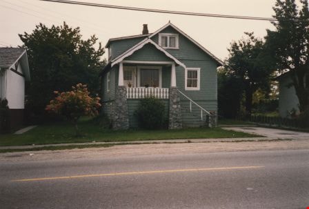
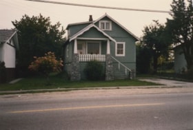
- Photograph of the Sutherland house, 8246 16th Avenue, built in 1912.
- Repository
- City of Burnaby Archives
- Date
- 1985
- Collection/Fonds
- Burnaby Historical Society fonds
- Subseries
- Bill Sutherland subseries
- Physical Description
- 1 photograph : col. ; 11.1 x 14.8 cm
- Description Level
- Item
- Record No.
- 202-001
- Access Restriction
- No restrictions
- Reproduction Restriction
- Reproduce for fair dealing purposes only
- Accession Number
- BHS1987-11
- Scope and Content
- Photograph of the Sutherland house, 8246 16th Avenue, built in 1912.
- Subjects
- Buildings - Residential - Houses
- Media Type
- Photograph
- Notes
- Title based on contents of photograph
- Annotation on the back of the photograph reads, "8246 16th Avenue. Built in 1912 by Mr. Sutherland."
- Geographic Access
- 16th Avenue
- Street Address
- 8246 16th Avenue
- Historic Neighbourhood
- East Burnaby (Historic Neighbourhood)
- Planning Study Area
- Second Street Area
Images