Narrow Results By
Decade
- 2020s 14
- 2010s 15
- 2000s 18
- 1990s 166
- 1980s 32
- 1970s 386
- 1960s 31
- 1950s 45
- 1940s 53
- 1930s 60
- 1920s 44
- 1910s
- 1900s 43
- 1890s 14
- 1880s 4
- 1870s 4
- 1860s 4
- 1850s 2
- 1840s 1
- 1830s 1
- 1820s 1
- 1810s 1
- 1800s 1
- 1790s 1
- 1780s 1
- 1770s 1
- 1760s 1
- 1750s 1
- 1740s 1
- 1730s 1
- 1720s 1
- 1710s 1
- 1700s 1
- 1690s 1
- 1680s 1
- 1670s 1
- 1660s 1
- 1650s 1
- 1640s 1
- 1630s 1
- 1620s 1
- 1610s 1
- 1600s
Subject
- Agriculture - Farms 4
- Buildings - Commercial - Grocery Stores 1
- Buildings - Industrial - Factories 1
- Buildings - Industrial - Saw Mills 1
- Buildings - Public - Post Offices 1
- Buildings - Residential - Houses 4
- Buildings - Schools 1
- Education 2
- Employment 1
- First Nations reserves - British Columbia 1
- Geographic Features - Lakes and Ponds 3
- Geographic Features - Roads 1
Creator
- Bateman, Caroline Mary Wettenhall 1
- Burnaby Village Museum 2
- Burnett & McGugan, Engineers and Surveyors 1
- Damer, Eric 1
- Ehlers, Edith "Edie" Fleming 1
- Fleming, Frances "Fanny" Waplington 1
- Fox, Colin Rhodes 1
- Garden, Hermon and Burwell 1
- Gauvreau, Narcisse B. 1
- Girl Guides of Canada 1
- Hill, Albert James 2
- Malik, Anushay 1
Person / Organization
- Burnaby Central Secondary School 1
- Ceperley, Grace 1
- Douglas Road School 2
- Dowad, Kathleen "Kay" 1
- Dowad, Martha Elias Shaheen 1
- Dowad, Naomi "Mamie" David 1
- Dowad, Norman W. "Norm" 1
- Dowad, Samuel Esper "Sam" 1
- Dowad, Wilfred "Wilf" 1
- Fraser Valley Nurseries 2
- Hill, Louis Claude "Claude" 1
- Kapoor Sawmills Limited 1
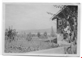
![Fraser Valley Nurseries, [191-?] (date of original), copied 1977 thumbnail](/media/hpo/_Data/_BVM_Images/1977/1977_0099_0017_001.jpg?width=280)
Fraser Valley Nurseries
https://search.heritageburnaby.ca/link/museumdescription575
- Repository
- Burnaby Village Museum
- Date
- [191-?] (date of original), copied 1977
- Collection/Fonds
- Burnaby Village Museum Photograph collection
- Description Level
- Item
- Physical Description
- 1 photograph : b&w ; 20.32 x 25.4 cm
- Scope and Content
- Photograph of the grounds of the Fraser Valley Nurseries. The grounds are fenced with wire and wooden posts.There is a large sign on the left of the photograph that reads "The Fraser Valley Nurseries, Ltd." There are a few barns or sheds on the nursery grounds. Behind the nursery can be seen a la…
- Repository
- Burnaby Village Museum
- Collection/Fonds
- Burnaby Village Museum Photograph collection
- Description Level
- Item
- Physical Description
- 1 photograph : b&w ; 20.32 x 25.4 cm
- Scope and Content
- Photograph of the grounds of the Fraser Valley Nurseries. The grounds are fenced with wire and wooden posts.There is a large sign on the left of the photograph that reads "The Fraser Valley Nurseries, Ltd." There are a few barns or sheds on the nursery grounds. Behind the nursery can be seen a large body of water, most likely Burnaby Lake. The accession register and the inscription on the photograph identify the location as just off Douglas Road (now Canada Way). The annotation on the back of the photograph reads: "Located off Canada Way."
- Subjects
- Agriculture - Farms
- Names
- Fraser Valley Nurseries
- Geographic Access
- Douglas Road
- Canada Way
- Nursery Street
- Burnaby Lake
- Accession Code
- HV977.99.17
- Access Restriction
- No restrictions
- Reproduction Restriction
- May be restricted by third party rights
- Date
- [191-?] (date of original), copied 1977
- Media Type
- Photograph
- Historic Neighbourhood
- Burnaby Lake (Historic Neighbourhood)
- Planning Study Area
- Lakeview-Mayfield Area
- Related Material
- For the right side of the two part panorama of the nurseries, see HV977.99.19
- Scan Resolution
- 600
- Scan Date
- 2023-07-11
- Notes
- Title based on contents of photograph
Images
![Fraser Valley Nurseries, [191-?] (date of original), copied 1977 thumbnail](/media/hpo/_Data/_BVM_Images/1977/1977_0099_0017_001.jpg)
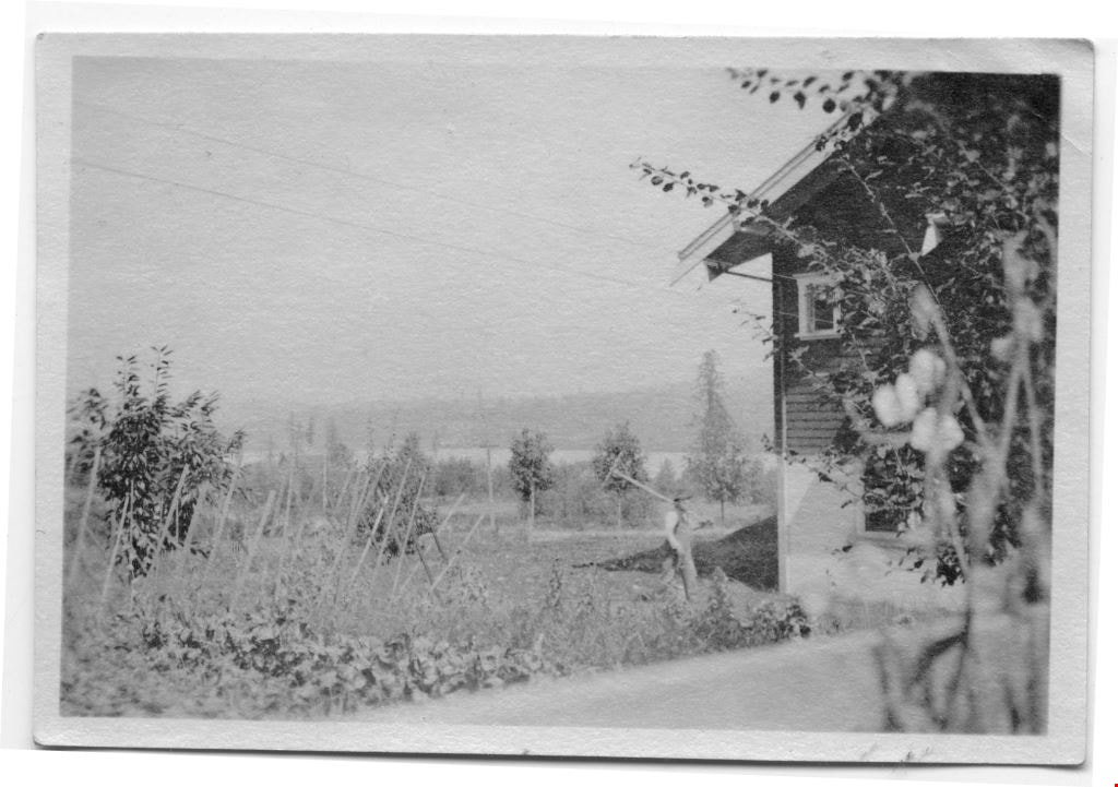
![Fraser Valley Nurseries, [191-?] (date of original), copied 1977 thumbnail](/media/hpo/_Data/_BVM_Images/1977/1977_0099_0019_001.jpg?width=280)
Fraser Valley Nurseries
https://search.heritageburnaby.ca/link/museumdescription577
- Repository
- Burnaby Village Museum
- Date
- [191-?] (date of original), copied 1977
- Collection/Fonds
- Burnaby Village Museum Photograph collection
- Description Level
- Item
- Physical Description
- 1 photograph : b&w ; 20.2 x 25.2 cm print
- Scope and Content
- Photograph of the grounds of the Fraser Valley Nurseries. The grounds are fenced with wire and wooden posts. There are a few barns or sheds on the nursery grounds. Behind the nursery can be seen a large body of water, most likely Burnaby Lake. The accession register identifies the location as j…
- Repository
- Burnaby Village Museum
- Collection/Fonds
- Burnaby Village Museum Photograph collection
- Description Level
- Item
- Physical Description
- 1 photograph : b&w ; 20.2 x 25.2 cm print
- Scope and Content
- Photograph of the grounds of the Fraser Valley Nurseries. The grounds are fenced with wire and wooden posts. There are a few barns or sheds on the nursery grounds. Behind the nursery can be seen a large body of water, most likely Burnaby Lake. The accession register identifies the location as just off Douglas Road (now Canada Way). An annotation on the back of the photo reads: "View Fraser Valley Nurseries."
- Subjects
- Agriculture - Farms
- Names
- Fraser Valley Nurseries
- Geographic Access
- Douglas Road
- Canada Way
- Nursery Street
- Burnaby Lake
- Accession Code
- HV977.99.19
- Access Restriction
- No restrictions
- Reproduction Restriction
- May be restricted by third party rights
- Date
- [191-?] (date of original), copied 1977
- Media Type
- Photograph
- Historic Neighbourhood
- Burnaby Lake (Historic Neighbourhood)
- Planning Study Area
- Lakeview-Mayfield Area
- Related Material
- For the left side of the two part panorama of the nurseries, see HV977.99.17
- Scan Resolution
- 600
- Scan Date
- 2023-07-11
- Notes
- Title based on contents of photograph
Images
![Fraser Valley Nurseries, [191-?] (date of original), copied 1977 thumbnail](/media/hpo/_Data/_BVM_Images/1977/1977_0099_0019_001.jpg)
Burnaby Girl Guides fonds
https://search.heritageburnaby.ca/link/museumdescription4614
- Repository
- Burnaby Village Museum
- Date
- 1914-2009
- Collection/Fonds
- Burnaby Girl Guides fonds
- Description Level
- Fonds
- Physical Description
- 22 scrapbooks : photographs + textual records + illustrations + digital files : col. (pdfs) + photographs : col. (tiffs) + col. (jpegs) + 222 photographs : b&w ; col. + 12 cm of textual records + ephemera
- Scope and Content
- Fonds consists of a collection of scrapbooks containing photographs, textual records, illustrations and ephemera along with individual photographs and textual records related to Burnaby Girl Guides. Records document the activities and functions of Burnaby Girl Guides through histories, journals, ne…
- Repository
- Burnaby Village Museum
- Collection/Fonds
- Burnaby Girl Guides fonds
- Description Level
- Fonds
- Physical Description
- 22 scrapbooks : photographs + textual records + illustrations + digital files : col. (pdfs) + photographs : col. (tiffs) + col. (jpegs) + 222 photographs : b&w ; col. + 12 cm of textual records + ephemera
- Scope and Content
- Fonds consists of a collection of scrapbooks containing photographs, textual records, illustrations and ephemera along with individual photographs and textual records related to Burnaby Girl Guides. Records document the activities and functions of Burnaby Girl Guides through histories, journals, newspaper clippings, certificates, awards, programmes, photographs, illustrations and newsletters. Scrapbooks were created by Burnaby Girl Guides and Girl Guide leaders and deposited with the Burnaby Girl Guide Archivist prior to being donated to the Burnaby Village Museum. Record descriptions are available at both item and file level. Fonds is arranged into the following series: 1) Burnaby Girl Guides scrapbooks and photographs series 2) Burnaby Girl Guides administrative records and histories series 3) Burnaby Girl Guides newsletters series 4) Burnaby Girl Guides memorabilia series
- History
- The Girl Guide Movement began in England in 1909 when girls in England demanded to take part in a Boy Scouts rally at the Crystal Palace in London, organized by Chief Scout and Boy Scout founder Lord Robert Baden-Powell. Following this event, Baden Powell asked his sister, Agnes Baden-Powell to help him start a similar organization for girls and Girl Guides was formed. Girl Guides came to Canada in 1910 and the first troop in British Columbia was registered in Victoria in 1912. In 1913 Amy Leigh moved to Burnaby from England and enquired about a Guiding company in her area and was disappointed to find none. On June 11, 1914 at the age of 17 years, Amy registered the 1st Burnaby Girl Guide Company and became the captain. On April 2, 1916 the 2nd Burnaby Guide Company registered and met at Edmonds School. In this same year, the very first Burnaby Girl Guide Rally event took place at Central Park and by 1920 another took place at the Burnaby Municipal Hall (Edmonds) and was attended by both Burnaby and New Westminster Guides. The First Burnaby Brownie Pack was registered on December 1922 with Mrs. W.J. Matherson as Brown Owl. The Brownie Pack met in a West Burnaby facility. The First Burnaby Land Ranger Co. was formed on November 29, 1923 and by 1924 Burnaby became a District with four Guide companies, four Brownie Packs and the Rangers. In 1923 records show Mrs. Gavin as commissioner, Mrs. C.F. Carter in 1924 and Miss Amy Leigh between 1926 and 1928. The first District camp was held near Sechelt in 1927 on the property of Mrs. Deal and Mrs. Nixon with annual camps held here until 1930 when the Guide camp at Wilson Creek was established. In 1929 Guides and Brownies began taking part in the Annual May Day Celebrations at Central Park. In 1930 Burnaby became a Division with Mrs. C.F. Carter as Division Commissioner and Mrs. G. Peel as District Commissioner for South Burnaby and in 1931 Miss Amy Leigh became the first North Burnaby Commissioner. The 5th Burnaby Girl Guide Company in North Burnaby began publishing a bulletin in 1935. In this same year Burnaby Girl Guides attended a rally for Lord and Lady Powell who were visiting Vancouver and Burnaby Girl Guides became affiliated with Greater Vancouver Girl Guide Council. The packs and companies of North Burnaby were attached to the eastern section of Vancouver while South Burnaby and South Vancouver District became another Division. Mrs. Pochin organized the Burnaby Lake District in 1943 becoming the first District commissioner (In 1927 Mrs. Peel had guides in this area). The first training classes for Girl Guides were held in 1943 in a hall on Buller Avenue at the BCER tracks and also Phillips Hall on McKay Avenue. By 1945 a training camp was held on Mrs. Pochin’s property on Deer Lake. South Vancouver, South Burnaby and Burnaby Lake Districts took part in the training which was a change over from war time service and the return of Pioneer camping. Miss E. Perition was in charge of camp which was attended by Mrs. J. Quinnell, Mrs. J. Albertson and many guiders. In 1946 Lady Baden Powel returned for a visit to Vancouver and there was a rally at Connaught Park and Chief Scout Lord Rowallyn held a rally at Brocton Point. In 1947 Mrs. J. Albertson became Division Commissioner for South Vancouver and South Burnaby. Districts of Burnaby Lake and South Burnaby each adopted a European child and undertook to send regular parcels and by 1948 these Districts became a Burnaby Division once more under Division Commissioner Mrs. W.M. Wall. In September 1949 the first Sea Ranger Crew “S.R.S. Royal Oak” was formed under the Skipper, Miss E. Periton. The S.R.S. Royal Oak met at All Saint’s Church Hall on Royal Oak Ave. In 1950 Packs and Companies in North Burnaby organized into a District under Mrs. Hebron and in 1953 Sperling District was organized by District Commissioner Mrs. Hancock. 1953 was also the same year that South Burnaby District was divided into three Districts: Central Park District under Commissioner Miss Perition, Douglas District under Commissioner Mrs. J. McKee Wilson and Kingsway under Commissioner Mrs. J.G. Fowler. A few years later, in 1955 the guides and brownies were out in force to welcome Lady Baden Powel at a rally held in the PNE Gardens building and by March 1956 Burnaby ceased to be a part of Greater Vancouver Area and was organized under two Divisions of the Province. The Sperling, Willingdon and Vancouver Heights Districts in North Burnaby became North Burnaby Division with Mrs. H. Hebron as Division Commissioner. With rapid population growth further decentralization became necessary and South Burnaby Division was split in two, adding the new division of Central Burnaby under Commissioner Miss E. Perition. Central Burnaby was composed of three Districts: Burnaby Lake, Central Park and a new District named “Windsor” under Mrs. C. Dumfries. South Burnaby was composed of three Districts: Kingsway, Edmonds and Lakeview (the latter two also referred to as Douglas with Mrs. McGeachie and Mrs. J. Park as the first commissioners of these two Districts). In 1957 Burnaby became an Area unto itself with three Divisions, and 9 Districts under Miss Periton as the first Area Commissioner. In February 1957, Burnaby entered into a contract with Vancouver Girl Guide Council to lease a part of the Wilson Creek campsite. Under the leadership of Area Commissioner, Miss Periton, work started on the development of the site with funds raised by both the Girl Guides, local citizens and associations. A camp committee was formed with representation from each Division and a lot of help from Miss Norah Weller, the Wilson Creek camp manager. Plans were laid for the site with a dining shelter, store room and cook stove contracted for while a subcommittee of men was appointed to purchase building supplies and organize work parties to build cabins, a staff house, water pipes and sanitary facilities. The site opened in May 1958 with $6000 expended on building and equipping the camp, while an official opening took place on June 8 and by July Girl Guides began camping on the site. The Burnaby Area Committee became a member of the Burnaby Community Council and a participant in Community Chest in 1958 and on May 1, the Burnaby Area office opened. By 1959, with further participation in North Burnaby, Sperling District was split to form Sperling and Hillview Districts and by 1960 Kingsway District of South Burnaby split to form Kingsway and Royal Oak Districts. By December 1960, Burnaby Area had 3 Divisions, 11 Districts with a total membership of 2, 331.
- Creator
- Girl Guides of Canada
- Accession Code
- BV015.35
- BV015.36
- BV016.49
- Access Restriction
- No restrictions
- Reproduction Restriction
- May be restricted by third party rights
- Date
- 1914-2009
- Media Type
- Textual Record
- Photograph
- Notes
- Title based on contents of fonds
- Some scrapbooks are only available in digital formats
- Accessions that form part of this fonds include: BV015.35; BV015.36; BV016.49
![Survey and Subdivision plans in New Westminster District Group 1 - Burnaby
, [1906-1910] thumbnail](/media/hpo/_Data/_BVM_Cartographic_Material/1977/1977_0093_0001a_001.jpg?width=280)
Survey and Subdivision plans in New Westminster District Group 1 - Burnaby
https://search.heritageburnaby.ca/link/museumdescription6970
- Repository
- Burnaby Village Museum
- Date
- [1906-1910]
- Collection/Fonds
- Burnaby Village Museum Map collection
- Description Level
- File
- Physical Description
- 7 plans : blueprint ink on paper + 2 plans : black ink on paper mounted on 2 sides of cardboard 76 cm x 102 cm
- Scope and Content
- Item consists of a large board of six New Westminster District Gp 1 subdivision plans mounted on one side and three New Westminster District Gp 1 subdivision plans mounted on the other side with scales ranging from one chain equals one inch to four chains equals one inch. Side A: 1. Blueprint "Pl…
- Repository
- Burnaby Village Museum
- Collection/Fonds
- Burnaby Village Museum Map collection
- Description Level
- File
- Physical Description
- 7 plans : blueprint ink on paper + 2 plans : black ink on paper mounted on 2 sides of cardboard 76 cm x 102 cm
- Material Details
- Scales [1:792] and [1:3168]
- Index number on edge of board reads: "1"
- Scope and Content
- Item consists of a large board of six New Westminster District Gp 1 subdivision plans mounted on one side and three New Westminster District Gp 1 subdivision plans mounted on the other side with scales ranging from one chain equals one inch to four chains equals one inch. Side A: 1. Blueprint "Plan / of Subdivision / of a portion / of / Lot 13, GR.1 / New Westminster District". Plan is bordered by Cumberland Street, Tenth Ave., Cariboo Street, Armstrong Street, "See Bd.145", Map No891 (Geographic location: Burnaby) 2."Plan / of Subdivision / of a portion / of / Lot 13, GR.1 / New Westminster District". Plan is bordered by Cumberland Street, Tenth Ave., Cariboo St. and Armstrong St. Pencilled annotations on plan read: "for Subdivisions see Board 145"; "Subdivided by H. Neville Smith". (Geographic location: Burnaby) 3. Blueprint "Plan / of Subdivision / of a part / of / Lot 155 / Group 1 / New Westminster District". Plan is bordered by North Arm of Fraser, Wiggins Rd. and Lot 173. Plan created by "NB Gauvreau" (Geographic location: Burnaby) Side B: 1. Blueprint plan which reads: "Albert J. Hill / P.L.S." at top with handwritten annotation: "Lot 85". The plan is bordered by Hastings Rd. and Burnaby Lake with names on lots identified as:"Laura Troop; Jas. Anderson and A. de W. Haszard". (Geographic location: Burnaby) 2. Blueprint plan which reads: "Albert J. Hill / P.L.S" at top with handwritten annotation: "Lot 85". The plan is bordered by Hastings Rd. and Burnaby Lake with names on lots identified as:"Laura Troop; A. de W. Haszard". (Geographic location: Burnaby) 3.Plan of "Survey of Road / for / Burnaby Council". "Albert J. Hill, M.A. Civil Engineer". Plan identifies "Centre Line Lot 10 / Present Road" at the centre and is bordered by Gunn Rd. at the top and Brunette River at the bottom. (Geographic location: Burnaby) 4.Blueprint "Plan / of Subdivision / Lot 97 Group 1/ N.W.D." Plan is bordered by Lots 93, 94 and 96 and Webster Road. Vancouver and New Westminster Road crosses the upper right corner of the plan and the New Westminster Vancouver Tramway runs through from Power House Rd. to Webster Road. Lower right corner identifies "W.N. Draper, P.LotS." (Geographic location: Burnaby) 5. Blueprint "Plan / of / The Subdivision of / Portion of / Lot 85, GP.1 / New Westminster District" Plan is bordered by Lots 79 / Byrne Drive; Burnaby Lake/ Esplanade and Lot 87. Plan is identified with "Albert J. Hill / B.C.LotS. / 19/6/09" (Geographic location: Burnaby) 6. Blueprint "Plan / of Subdivision/ of / Lot 155B, Group One / New Westminster District". Plan is bordered by Lots 155A, 155C, 162 / Byrne Road, 166A / Wiggins Road with Spruce Street running through the middle and Westminster- Eburne Ry. Right of Way running diagonally. Plan is identified with "Albert J. Hill (Geographic location: Burnaby)
- Accession Code
- HV977.93.1
- Access Restriction
- No restrictions
- Reproduction Restriction
- No known restrictions
- Date
- [1906-1910]
- Media Type
- Cartographic Material
- Scan Resolution
- 300
- Scan Date
- 2019-07-16
- Scale
- 72
- Notes
- Title based on contents of file
- Stamp on plans reads: "ALBERT J. HILL M.A. / CIVIL ENGINEER / and / PROVINCIAL LAND SURVEYOR / NEW WESTMINSTER / BC"
- Scale is measured in chains. (One chain equals 792 inches)
Images
![Survey and Subdivision plans in New Westminster District Group 1 - Burnaby
, [1906-1910] thumbnail](/media/hpo/_Data/_BVM_Cartographic_Material/1977/1977_0093_0001a_001.jpg)

![Survey and Subdivision plans in New Westminster District Group 1 – Burnaby
, [1861]-[1910] thumbnail](/media/hpo/_Data/_BVM_Cartographic_Material/1977/1977_0093_0019a_001.jpg?width=280)
Survey and Subdivision plans in New Westminster District Group 1 – Burnaby
https://search.heritageburnaby.ca/link/museumdescription6988
- Repository
- Burnaby Village Museum
- Date
- [1861]-[1910]
- Collection/Fonds
- Burnaby Village Museum Map collection
- Description Level
- File
- Physical Description
- 14 plans : 3 plans : black ink on paper hand col. + 7 plans : black ink on paper + 4 plans : graphite on paper mounted on 2 sides of cardboard 76 x 102 cm
- Scope and Content
- Item consists of a large board of four New Westminster District Gp 1 - subdivision plans mounted on one side and ten New Westminster District Gp 1 - subdivision plans mounted on the other side. Side A: 1. "Plan /of / Lots 166A, 166 and 167 /, Gr.1, N.W.D. / Showing Misconstructed Roads in Gree…
- Repository
- Burnaby Village Museum
- Collection/Fonds
- Burnaby Village Museum Map collection
- Description Level
- File
- Physical Description
- 14 plans : 3 plans : black ink on paper hand col. + 7 plans : black ink on paper + 4 plans : graphite on paper mounted on 2 sides of cardboard 76 x 102 cm
- Material Details
- Scales [between 1:2376 and 1:7920]
- Index number on edge of board reads: "19"
- Scope and Content
- Item consists of a large board of four New Westminster District Gp 1 - subdivision plans mounted on one side and ten New Westminster District Gp 1 - subdivision plans mounted on the other side. Side A: 1. "Plan /of / Lots 166A, 166 and 167 /, Gr.1, N.W.D. / Showing Misconstructed Roads in Green / 5 chs = 1 in.". (plan is drawn in black ink and hand coloured in red, green and orange ink). A section in the centre of the plan is coloured in red ink and identified as "C.S. Richmond" running from the North Arm of Fraser River to Wiggins Road and divided by "New Wiggins Rd. (as gazetted)" (coloured in orange ink) and two"Constructed Road(s)" (coloured in green ink). Plan is initialed by: "RB" [sic] (in blue pencil crayon) 2. Plan of / Subdivision of / Lot 166 / Group One / New Westminster District / Scale 4 chs = 1 in. / Map No 524". Plan is drawn in graphite and signed by "Surrig [sic] Welhams [sic] / P.L.S." Plan is initialed by: "RB" [sic] (in blue pencil crayon) 3. Plan of "Survey / of Highway / For / Burnaby Council / in / Lots 13 _14 / Group One / Scale 4 chs = 1 in." Signed by "Albert J. Hill, P.L.S." Caribou Street and Caribou Road run through the centre of the plan. Plan is stamped: "Albert J. Hill, Civil Engineer / and / Provincial Land Surveyor, / New Westminster, / B.C.". Plan is initialed by: "RB" [sic] (in blue pencil crayon) 4. A Plan of Lots 166A, 166 and 167, Group One, New Westminster District (drawn in graphite). A section in the centre of the plan is identified as "C.S. Richmond" running from the North Arm of Fraser River and divided by "New Wiggins Rd. (as gazetted)" and two "Constructed Road(s)". Plan is initialed by: "RB" [sic] (in blue pencil crayon) Side B: 1. Small plan drawn in black ink (no title) identifying lots north of the "North Arm" of the Fraser River. Lots identified include: Lot 99, Lot 98, Lot 157, Lot 158, Lot 163, Lot 162, Lot 159, Lot 163, Lot 162, Lot 165, Lot 166A, Lot 155B, Lot 155A and Lot 159. "Scale 40 chains to one inch" . Plan is initialed by: "RB" [sic] (in blue pencil crayon) (Geographic location: Burnaby) 2. Small plan drawn in black ink (no title) identifying lots north of the North Arm of the Fraser River as "Lots 155, 155A, 155B, 155C, 162, 163, 164, 165, 166A and 167". Plan is initialed by: "RB" [sic] (in blue pencil crayon) (Geographic location: Burnaby) 3. Small plan drawn in black ink (no title) which identifies "Lot 151 / Reserve/ for / Race Course"; "Reserve / 64 A / L. 152 G.1"; and other Lots: 32, 33, 34, 35, 36, 38, 39. The plan is signed "Surveyor G.Turn [sic] July / 61 / from Vol 40 R.L. notes [sic]" Plan is stamped: "Albert J. Hill, Civil Engineer / and / Provincial Land Surveyor, / New Westminster, / B.C." Plan is initialed by: "RB" [sic] (in blue pencil crayon) (Geographic location: Burnaby) 4. Small plan drawn in black in with faded red colouring on centre lot identified as "Lot 34" running north from "Vancouver Road" . Plan is stamped: "Albert J. Hill, Civil Engineer / and / Provincial Land Surveyor, / New Westminster, / B.C." Plan is initialed by: "RB" [sic] (in blue pencil crayon) (Geographic location: Burnaby) 5. Plan drawn in graphite and identified as "Lot 98, Gr.1," along with the intials "RB" [sic] (both are handwritten in blue crayon pencil on top of plan) The B.C.E.Railway is identified running through the plan along with Jubilee Road and Royal Oak Road. The plan is signed with the name "Wm. Murray" and the Plan is stamped: "Albert J. Hill, Civil Engineer / and / Provincial Land Surveyor, / New Westminster, / B.C.". (Geographic location: Burnaby) 6. Plan drawn in graphite identified as "Port Lot 13, Gr.1" along with the intials "RB" [sic] (both are handwritten in blue crayon pencil on top of plan) Plan is stamped: "Albert J. Hill, Civil Engineer / and / Provincial Land Surveyor, / New Westminster, / B.C.". (Geographic location: Burnaby) 7.Plan drawn in black ink and identified as "Lot 98 G.1" along with the intials "RB" [sic] (both are handwritten in blue crayon pencil on top of plan). A "Road Reservation" is identified running north between "Electric Tramway" and connecting with "Royal Oak Road". Plan is stamped: "Albert J. Hill, Civil Engineer / and / Provincial Land Surveyor, / New Westminster, / B.C." (Geographic location: Burnaby) 8. Plan drawn in black ink and divided into two sections, the upper plan is identified as "Portion / Lots 100 / area / 101, Gr.1" and the lower plan is identified as "Portion L. 3 G. 1" along with the intials "RB" [sic] (these identifiers are handwritten in blue crayon pencil on top of the plan). Portions of Lot 100 and Lot 101 are each divided into 6 sections and the Portion of Lot 3 plan is divided into 24 sections. The plan includes a note in black ink that reads: " Received from Wm Fromme [sic] / from Wm. Trapp / Nov. 28, 1895 / A. J. T...[sic]". (Geographic location: Burnaby) 9. Plan drawn in black ink (no title) identifying soil, buildings and geographic features in southern Burnaby. The plan is bordered by "New Westminster City" (Tenth Avenue and DL 172) to the south east and DL 173 to the south, DL 158 to the west and the B.C.E. Tramway to the north. Plan includes District Lots: 155A, 158, 159, 171, 160, 53 and 95 and identifies soil, marshland and ravines throughout. Plan identifies the following features: a "Team Road" running through Lots 158 and 159 along with "Fair Orchard Soil / Even Surface Throughout / No Ravines", "Gravel and Shingle" (bottom of Lot 158), "North Arm Road" crossing "Byrne Road" and connecting with "Power House Road" which runs north to connect with "Highland Park Station" and the B.C.E. Tramway, "Power Ho" in the northeast corner of DL 160, a "Brook" connected with a "Deep Ravine" running between DL 53, DL 95 and DL 160 along with "Good Soil" and "Fair Orchard Soil" identified nearby in DL 95. Scale is identified as "10 chs = 1 in." Plan is stamped: "Albert J. Hill, Civil Engineer / and / Provincial Land Surveyor, / New Westminster, / B.C." Plan is initialed by: "RB" [sic] (in blue pencil crayon) (Geographic location: Burnaby) 10. Plan drawn in black ink (no title) with Burnaby Lake and Deer Lake at the centre. The plan is bordered by the following District Lots identified as: 117, 118 and 68 to the west, Lots 80, 79 and 85 to the southwest, Lots 11, 13, and 1 (City of New Westminster) to the south east, the North Road boundary to the east and Lots 8, 56, 57, 59, and 136 to the North. The lower right hand corner of the plan has a small inset which reads: "Burnaby Lake" and "Page 19 R.B. Notes". Plan is initialed by: "RB" [sic] (in blue pencil crayon) (Geographic location: Burnaby)
- Creator
- Hill, Albert James
- Accession Code
- HV977.93.19
- Access Restriction
- No restrictions
- Reproduction Restriction
- No known restrictions
- Date
- [1861]-[1910]
- Media Type
- Cartographic Material
- Scan Resolution
- 300
- Scale
- 72
- Notes
- Title based on contents of file
- Scale is measured in chains. (One chain equals 792 inches)
- The term "Lot" can also refer to a "District Lot”
- Some plans are stamped: "Albert J. Hill, Civil Engineer / and / Provincial Land Surveyor, / New Westminster, / B.C." and intialed: "RB" [sic]
Images
![Survey and Subdivision plans in New Westminster District Group 1 – Burnaby
, [1861]-[1910] thumbnail](/media/hpo/_Data/_BVM_Cartographic_Material/1977/1977_0093_0019a_001.jpg)

Waplington family fonds
https://search.heritageburnaby.ca/link/museumdescription4613
- Repository
- Burnaby Village Museum
- Date
- 1911-2004
- Collection/Fonds
- Waplington family fonds
- Description Level
- Fonds
- Physical Description
- 1 album (88 photographs + textual records) + 2 photographs in frames
- Scope and Content
- Fonds consists of records documenting the lives of both the Waplington and Fleming families who resided at 3813 Deer Lake. Records include a family photograph album; two framed portraits: one of John Waplington and Doris Waplington (nee Caswell) (possibly on their wedding day) and Frances (nee Wapl…
- Repository
- Burnaby Village Museum
- Collection/Fonds
- Waplington family fonds
- Description Level
- Fonds
- Physical Description
- 1 album (88 photographs + textual records) + 2 photographs in frames
- Scope and Content
- Fonds consists of records documenting the lives of both the Waplington and Fleming families who resided at 3813 Deer Lake. Records include a family photograph album; two framed portraits: one of John Waplington and Doris Waplington (nee Caswell) (possibly on their wedding day) and Frances (nee Waplington) and Ray Fleming; a copy of a handwritten memoir "The Way it Was / 1913-1925"; as well as a computer printed copy of "In and Out of / A Cedar Shake Shack" / "The life of a little girl from World War I / to Canada's Diamond Jubilee" both written by Frances L. Fleming (nee Waplington). Fonds is arranged into series: 1) Waplington and Fleming families album series 2) Frances Fleming manuscripts series 3) Waplington family documents series 4) Waplington family photographs series
- History
- John (Jack) Waplington emigrated from Nottingham, England in 1904, arriving in Quebec City and continuing on to Ontario before eventually settling in British Columbia. Somewhere on his journey his right hand was crushed in an industrial accident and amputated. Following his recovery, Jack continued to work his way across Canada until he found employment at Stave Falls, B.C. and married Sarah Alice Cogswell (nee Nickerson). Jack and Sarah (nicknamed Cutie) Waplington had three children; Frances Louise Waplington (1913-2004), John Hazen Waplington and Grace Bancroft Waplington. In 1916, the Waplingtons rented the Walker house at Hill Station on the Burnaby Lake Interurban Line and in 1920 Jack built a cedar shack on 5 acres of land at 4925 Douglas Road (northwest corner of Douglas and Laurel). According to a memoir by Frances Waplington, life was rough living in the cedar shack on Douglas Road with no electricity or running water and by 1925 the family was lucky to purchase "Brookfield", the former home of Louis Claude Hill located at 3813 Deer Lake Avenue. The home was not in good shape having been empty for some time but was located on ¾ of an acre and purchased at a fair price of $1000. The house was surrounded by grass and flowers gone wild and very tall fir trees. The house had running water, electricity and was heated by a wood burning stove in the kitchen and hall and a fireplace in the living room. There was no refrigeration other than the ice box. The three Waplington children, Frances, John and Grace continued to attend Douglas Road School. The family renovated and restored the house at Deer Lake as well as the grounds, adding in flower and vegetable gardens. The large area of grass which formerly housed a tennis court was rolled flat and reseeded. Jack Waplington continued to work for the power company which became B.C. Electric Company and eventually B.C. Power and Hydro. The Waplingtons continued to live at 3813 Deer Lake until 1946 when they sold their home to their daughter Frances who married Ray Fleming. Jack and Sarah Waplington retired and moved to Lasquiti island. Frances "Fanny" Waplington married Reyland "Ray" Fleming October 11, 1935. Ray and Frances Fleming had three children; John (Jack) Reyland, Edith (Edie) Louise and Sara Maureen. In 1941 Ray was hired by the B.C. Electric Company to work at Buntzen Lake hydro station. There was no housing at the hydro station so the family lived on a 42’ coastal boat, the Cohoe Bay tied up to the dock at Buntzen Lake. Since it was war time, there was fear that the two hydro plants at Stave Falls and Buntzen Lake could be targeted for bombing so the Fleming family had to learn about air raid sirens, bunkers, helmets and gas masks. The children attended a one room classroom at Buntzen Lake and participated in school drills when the air raid siren sounded. By 1947 the Fleming family moved to the Waplington home at 3813 Deer lake Avenue after purchasing it from Frances’ parents. Ray continued to work for B.C. Electric and eventually B.C. Power and B.C. Hydro. The children walked or rode bicycles to and from Douglas Road School. At the time the family moved into their home there were no buses only the Interurban streetcar to take them to Vancouver. Douglas Road station was the nearest stop to Deer Lake on the Burnaby Lake Line. The closest neighbours were the Oakalla Prison farm (located off of Royal Oak hill overlooking Deer Lake) and the Ceperley mansion. Prison breaks were common and both the Waplington and Fleming families would often hear air raid sirens blare to warn them. The neighbourhood would go on high alert and the children would immediately run home to safety. Mr. Fleming was well prepared with his 22 rifle nearby should it be needed. After Sarah Waplington died, Jack Waplington returned to Deer Lake to live in a house trailer on the property that was owned by the Flemings. In 1959, after the Fleming children had grown and moved on, Ray and Frances Fleming sold the property to the Municipality of Burnaby. The Municipality rented it out for several years prior to its demolition around 1970 to make way for Burnaby’s Heritage Village. Frances Louise Fleming received her teaching degree from the Vancouver Normal School at the end of World War II but found it extremely difficult to secure a permanent teaching position as a woman. Between 1944 and 1954, Frances was hired and fired eight times from teaching positions despite excellent reports. Finally in 1954, she was invited to teach in an adjoining district with a permanent teaching appointment to follow. Over the years, Frances taught in Vancouver, Burnaby, Pender Harbour and served as vice principal at Magee Secondary. In the early 1970s Frances was appointed provincial superintendent of schools at Quesnel and then moved to Victoria to be assistant superintendent of integrated and supportive services and then in 1973, she became assistant superintendent of the department of public intstruction. Frances retired from teaching soon after, moving to the Sunshine Coast with her husband Ray. Frances was awarded the Order of British Columbia in 1997, was an accomplished writer who regularly contributed articles to the Vancouver Sun newspaper and othe publications. Ray Fleming died in 2002 and Frances Fleming died in 2004.
- Accession Code
- BV016.46
- Date
- 1911-2004
- Media Type
- Photograph
- Textual Record
- Arrangement
- Series arrangement is based on physical arrangement of records by donor. Family album was scanned in it's original order and items from within family album were removed and described at item and file level.
- Notes
- Title based on content of fonds
![Deer Lake Drive, [1918] thumbnail](/media/hpo/_Data/_BVM_Images/1972/1972_0051_0012_001.jpg?width=280)
Deer Lake Drive
https://search.heritageburnaby.ca/link/museumdescription1085
- Repository
- Burnaby Village Museum
- Date
- [1918]
- Collection/Fonds
- Burnaby Village Museum Photograph collection
- Description Level
- Item
- Physical Description
- 1 photograph : b&w ; 12.9 x 32.9 cm
- Scope and Content
- Photograph is a panorama of Deer Lake Drive, including the Ceperley mansion and the surrounding grounds of the home to the left of the picture. The photograph, taken from the water tower, with Burnaby Lake in the background. In the midground, following the horizon line, power poles can be seen. Far…
- Repository
- Burnaby Village Museum
- Collection/Fonds
- Burnaby Village Museum Photograph collection
- Description Level
- Item
- Physical Description
- 1 photograph : b&w ; 12.9 x 32.9 cm
- Scope and Content
- Photograph is a panorama of Deer Lake Drive, including the Ceperley mansion and the surrounding grounds of the home to the left of the picture. The photograph, taken from the water tower, with Burnaby Lake in the background. In the midground, following the horizon line, power poles can be seen. Farm lands are visible leading down to the homes of the Andersons. An annotation on the back of the photo in pencil reads, "Deer Lake Dr." and an annotation in blue pen reads, "1918."
- Geographic Access
- Deer Lake Drive
- Deer Lake Avenue
- Street Address
- 6344 Deer Lake Avenue
- Accession Code
- HV972.51.12
- Access Restriction
- No restrictions
- Reproduction Restriction
- No known restrictions
- Date
- [1918]
- Media Type
- Photograph
- Historic Neighbourhood
- Burnaby Lake (Historic Neighbourhood)
- Planning Study Area
- Douglas-Gilpin Area
- Scan Resolution
- 600
- Scan Date
- 2023-04-04
Images
![Deer Lake Drive, [1918] thumbnail](/media/hpo/_Data/_BVM_Images/1972/1972_0051_0012_001.jpg)
E.W. Bateman family fonds
https://search.heritageburnaby.ca/link/museumdescription15157
- Repository
- Burnaby Village Museum
- Date
- [1857]-[195-]
- Collection/Fonds
- E.W. Bateman family fonds
- Description Level
- Fonds
- Physical Description
- 63 photographs + 6 cm of textual records
- Scope and Content
- Fonds consists of photographs of the family of Edwin Wettenhall Bateman and residences including Elworth house, along with letters written by Colin Rhodes Fox during World War II. Fonds is arranged into the following series: 1) Bateman family photographs series 2) Bateman family World War II lette…
- Repository
- Burnaby Village Museum
- Collection/Fonds
- E.W. Bateman family fonds
- Description Level
- Fonds
- Physical Description
- 63 photographs + 6 cm of textual records
- Scope and Content
- Fonds consists of photographs of the family of Edwin Wettenhall Bateman and residences including Elworth house, along with letters written by Colin Rhodes Fox during World War II. Fonds is arranged into the following series: 1) Bateman family photographs series 2) Bateman family World War II letters series
- History
- Edwin Wettenhall "E.W." Bateman was born in 1859 in Sandbach, Cheshire, to James and Caroline Mary Wettenhall Bateman (their home in Sandbach was called Elworth Cottage). When he was twenty-one, E.W. Bateman immigrated to Manitoba, Canada where he met Catherine “Cassie” Dale, daughter of George and Sarah Gillon Dale. They were married in Portage La Prairie, Manitoba on November 9, 1886. Edwin and Cassie had seven children, the eldest Edna Caroline Annie (Corner) (1889-1969); George Edwin (1890-? ); Mamie (McWilliams) (1892-1979); Marianne “May” Bateman (1894-1990); Warren Stafford (1896-1954); Jessie (Fox Kemp) (1899-1978) and John Carey (1901-1945). Catherine “Cassie” (Dale) Bateman died in Portage La Prairie in 1909. After Cassie's death, Edwin was transferred to Vancouver by the Canadian Pacific Railway where he married Cassie’s younger sister Mary Dale (1896-1935). Edwin moved his six of his seven children to Vancouver (not including George). Edwin and Mary (Dale) Bateman first lived at 7th and Balsam Street in Vancouver and in 1920, they decided to move to the quieter atmosphere of the Burnaby Lake- Deer Lake area. By this time Edwin Wettenhall Bateman was a retired CPR executive. He moved his wife and daughter Marianne “May” Bateman to Deer Lake and commissioned architect, Enoch Evans to build 'Elworth' house (named after Edwin’s family home in Sandbach, Chesire). The house was completed by contractor William Dodson in 1922 and located at the site of what would become Heritage Village and later, Burnaby Village Museum, 6501 Deer Lake Avenue. The Batemans lived at this location for thirteen years before moving back to Vancouver in May of 1935. Mary Dale Bateman died in July 1935 and sometime after, Edwin W. Bateman married Dora Coulton. Edwin W. Bateman died in 1957 at the age of 98. Edna Caroline Bateman married Raymond Westley Corner in 1920 and had a daughter named Catherine Mary (Levins). Edna and Raymond lived in Kelowna. George Bateman married Louise Agness Birss in January 1910 and continued to live in Manitoba. Mamie Dale Bateman married George Lloyd McWilliams in 1915. The couple had two children, Warren Finley McWilliams and Bruce McWilliams. Mamie and George McWilliams lived with their family on Douglas Road across the road from Elworth house in Burnaby. Warren McWilliams was on North Atlantic convoy duty during World War I from 1942 to 1944. Warren McWilliams died in 2004. Warren Stafford Bateman married Norah Withington in Burnaby in 1924; Winifred Dare Webster in Burnaby in 1932 and Dorothy Margaret Buchanan in New Westminster in 1949. Warren and Winnifred “Winnie” Webster celebrated their marriage at Elworth house in 1932. Warren served in World War I. Jessie Madeline Bateman married Ernest Denby Fox (1900-1945) in 1921. Jessie and Ernest Fox had three children, Colin Rhodes Fox (1921-2005); Mary “Betty” (Gludo) and Allan Fox. Jessie and Ernest Fox operated a small logging company near Powell River, B.C. Sometime after the death of her first husband, Ernest Denby Fox, Jessie married James Kemp. The youngest child of Edwin and Cassie, John “Carey” Bateman married Sophia Spak (1899-1977) in 1925. On September 10, 1939, the day that Canada declared war on Germany, Colin Rhodes Fox (eldest son of Jessie and Ernest Fox) enlisted in the army at the age of 18 years. Colin initially served in an anti-aircraft unit, but was soon transferred to the Field Artillery. During his service overseas, Colin wrote letters to family members including his aunt May Bateman who was living in Burnaby. Colin went through basic artillery training in Edmonton before heading overseas to the United Kingdom with his unit, the 13th Field Regiment , 44th Canadian Field Battery of the Royal Canadian Artillery and later the 78th Canadian Field Battery in Germany and Holland . Colin was wounded on June 8, 1944 (two days after D-Day) but returned to serve in Holland and Germany until the war ended. Colin suffered bullet and shrapnel wounds while laying communication cable from the Normandy beachhead. In 1946, Colin married Susan Streika (Striha) of Pitt Meadows and he began a thirty five year career in the B.C. Telephone Company on Vancouver Island. Colin and Susan had three children; Gary, Elaine and Irene. Colin Rhodes Fox died in 2005. The E.W. Bateman house, "Elworth" is a heritage building on the site of the Burnaby Village Museum. The site is an important cultural feature for the interpretation of Burnaby’s heritage to the public. The E.W. Bateman House was purchased by Burnaby in 1970 and became the focal point for the development of the Museum. Both the interior and exterior of the house have been restored and interpreted to the date of original construction, including recreated room interiors and period furnishings.
- Accession Code
- HV974.22
- HV974.90
- HV975.120
- HV976.37
- HV979.32
- BV985.1003
- BV986.21
- BV992.29
- BV994.22
- BV004.28
- BV004.84
- BV020.27
- Date
- [1857]-[195-]
- Media Type
- Photograph
- Textual Record
- Related Material
- See also: Interview with Marianne May Bateman February 22, 1978 - Tracks 1-4. City of Burnaby Archives Item No. MSS137-014-1
- Notes
- Title based on contents of fonds
Interview with Kalwant Singh "Nadeem" Parmar
https://search.heritageburnaby.ca/link/museumdescription19346
- Repository
- Burnaby Village Museum
- Date
- [1600-2022] (interview content), interviewed 7 Oct. 2022
- Collection/Fonds
- Burnaby Village Museum fonds
- Description Level
- Item
- Physical Description
- 2 sound recordings (wav) (111 min., 51 sec.) + 1 sound recording (mp3) (111 min., 51 sec.)
- Scope and Content
- Item consists of a recording of an oral history interview with Kalwant Singh "Nadeem" Parmar conducted by interviewers, Anushay Malik and Rajdeep with assistance from Burnaby Village Museum Assistant Curator, Kate Petrusa. During the interview Kalwant Singh "Nadeem" Parmar discusses and provides in…
- Repository
- Burnaby Village Museum
- Collection/Fonds
- Burnaby Village Museum fonds
- Series
- Museum Oral Histories series
- Description Level
- Item
- Physical Description
- 2 sound recordings (wav) (111 min., 51 sec.) + 1 sound recording (mp3) (111 min., 51 sec.)
- Material Details
- Interviewers: Anushay Malik, Rajdeep Co Interviewer and technical support: Kate Petrusa Interviewee: Nadeem Parmar Location of Interview: Residence of Nadeem Parmar in Burnaby Interview Date: October 7, 2022 Total Number of tracks: 2 Total Length of all Tracks: 01:51:51 min Digital master recordings (wav) were recorded onto two separate audio tracks, edited and merged together and converted to mp3 for access on Heritage Burnaby
- Scope and Content
- Item consists of a recording of an oral history interview with Kalwant Singh "Nadeem" Parmar conducted by interviewers, Anushay Malik and Rajdeep with assistance from Burnaby Village Museum Assistant Curator, Kate Petrusa. During the interview Kalwant Singh "Nadeem" Parmar discusses and provides information on; his ancestral background, his education, his employment background, his experiences of racial discrimmination as a South Asian immigrant, saw mills established by South Asian relations in Paldi (Vancouver Island), in North Vancouver and Burnaby, family relations in the South Asian Canadian community and in regions in Punjab, the caste system, his literary works, locations of family homes in Burnaby, the architectural design of his house, personal stories and anecdotal information as a South Asian Canadian living and working in Canada. 00:00 – 01:45 The framework and purpose of the interview is explained to interviewee Nadeem Parmar by interviewers Rajdeep and Anushay Malik. The interviewers explain how the information from this interview can be drawn on for Burnaby Village Museum’s future exhibits and also how researchers will learn more about the history of the South Asian community in Burnaby through residents’ stories. Interview begins with Nadeem providing his full name "Kulwant Singh Parmar". He clarifies that his name was given to him by his grandfather who was a civil engineer and that his father also worked as a civil engineer. Nadeem expresses that he was born with a “silver spoon in his mouth” as a descendent of his maternal grandfather who was a successful landlord. Nadeem explains that when the Partition of India came into effect, (1947) he was 11 years old. He and his family left the partitioned side, his native village was located in Punjab and his forefathers were located in Rajasthan. 3:20 – 4:57 Nadeem explains further about his forefathers who came from Rajasthan. He shares information about his ancestor on his father’s side, named Vijay Singh who was friends with Emperor Jahangir. When fighting began against Jahangir he left the area to head to the middle of central India, then to the Punjab area with small states. As a clan, as a Parmar, he conveys there were about eleven or twelve villages with the same name. Interviewer, Anushay helps Nadeem to clarify the time period of this information. Nadeem refers to the time period being similar to the epic historical film “Moghal-e-Azam” and Anushay confirms the time period being the 1600s when they left Rajasthan. 4:58 – 10:59 Interviewer Anushay asks Nadeem to about his migration to Canada. Nadeem conveys that his first ancestor on his in-laws side of the family migrated around 1889. Further discussion ensues about reading Punjabi and how interviewer Rajdeep can read Punjabi and that she comes from the village of "Lakhpur" in Punjab. Rajdeep notes that “Lakhpur” is near "Phagwara". Nadeem clarifies that his village is "Panchat" and this family used to live in "Phagwara". and Nadeem and Rajdeep compare their familiarity and memories of the area. Nadeem conveys some of his comments in Punjabi and then changes to English. Nadeem recollects when the Japanese bombarded Shillong, he was around seven years old and attended missionary school. The only languages that were taught were English and Persian. Nadeem conveys that his mother had hopes of Nadeem becoming an army officer and moving up the ranks but Nadeem wasn’t interested. Nadeem attended college, graduated with a Bachelor of Science, BSC with Physics and Chemistry, followed by another Bachelor’s Degree in Political Science and finally a degree in his favourite subject in the language of Urdu. He completed these degrees in Punjab in Doaba College, Jalandher. Nadeem recollects how he started teaching but wasn’t getting paid very well. When he was at college, with encouragement from his professor, Veer Pankalia [sic] he began writing poetry and short plays. His professor also introduced him to a famous poet of Punjab, Mila Ram Offa [sic] and he gave him the name of Nadeem. Nadeem explains the meaning of the name “Nadeem” “…the one who know about it, inside out…” even though we generally think of the meaning being “friend” it’s not just about friend. 11:00 -24:48 Nadeem provides background information on how he ended up marrying his future wife who was born in India and immigrated to Canada with her family. Nadeem explains how the marriage was arranged through family relations that were already established in Punjab over a century ago. One of his wife’s ancestors, head of the family called “baniye” (traders) immigrated to Canada in [1899]. This relation returned to Punjab where he had nephews, the youngest of the nephews was Nadeem’s father (Lashman Singh Manhas) in law’s father (Sher Singh Manhas). He expresses that his wife’s ancestor couldn’t bring Nadeem’s father in law’s father since he was only 12 or 13 years old but he brought three of the nephews back to Canada with him. The nephews were named, Pola Singh, Ginaya Singh and Doman Singh (also named Dolmans). He describes how the group left India but it took them two to three years before they arrived in Canada. The group travelled to Burma, Indonesia and Hong Kong before landing in San Francisco. From San Francisco they walked and worked on the rail line before entering Canada and arriving in Grand Forks. The men got work on the construction of the Canadian Pacific Railway (CPR) and eventually made their way to the lower mainland. Nadeem conveys that the younger brother of Ginaya Singh, Maya Singh joined the others in Canada taking the same route, arriving in Bridal Falls where they were working at a saw mill and in CP rail construction. He describes Maya Singh as business minded and since he was too young to work in the mill, he began working as a cook and then began growing potatoes on land that he leased from a Dutch land owner. The local mill at Bridal Falls was facing bankruptcy and Maya Singh arranged to lease the mill, eventually buying it. From there the group moved their business to Strawberry Hill in Surrey and when the sale of logs declined, they moved over to Vancouver Island and established a sawmill with Doman Singh in the community of Paldi (originally known as Mayo Lumber) near Duncan. He explains further how the South Asian community helped each other like they did back home. He clarifies that his father in law’s father is the youngest cousin of Ginaya and Doman Singh and when he died, his father in law’s younger brother started Kashmir Lumber. Eventually his father in law (Lashman Singh Manhas) and the rest of the whole family including cousins and nephews were sponsored by their relations and immigrated to Canada. Nadeem explains how in 1959, his brother in law returned home to Punjab to get married, bringing his family with him. He tells of how during this time period, a marriage was arranged by his parents for him to marry his future wife. Nadeem recollects how this came to be. Nadeem and his wife Surjeet married in Punjab in December 1960, Nadeem was 24 years old and his wife was 18 years old. 24:49 – 39:42 Nadeem describes how he obtained his teaching degree from Ramgarhia College in Phagwara (located in the Kapurhtala district of Punjab) and after a disagreement with a teacher at home, he decided to go to England. He explains how he joined his brother who had moved to England and was working as a labourer. Nadeem tells of the difficulties he faced applying for a teaching job in England and how he had to go back to school to help with his English pronunciation. Nadeem explains that after taking this course, he got work teaching Grade two students which he felt was below his qualifications (he mentions that while living in Punjab, he was a Secondary School teacher) and the pay was very low. He discovered that his brother was making more money working as a labourer so Nadeem became discouraged and quit. When Nadeem couldn’t find work as a labourer, his brother advised him to shave off his beard. Nadeem conveys how difficult it was for him to shave off his beard and how once he was clean shaven he got work as a sweeper in a factory. He shares his experience of working in the factory and of how with his former education he got himself promoted to a more technical position. With encouragement from his employer, Nadeem enrolled in technical courses which lead to him obtaining an HNC Engineering Degree. He completed the course work in two years, obtaining skills in microwave communication becoming the senior test engineer at the factory. While working in this position, Nadeem shares how he suffered discrimination when he was passed over for a senior chief engineer position at the factory by a less educated and experienced employee. 39:43 – 53:38 Nadeem recollects how things changed for him in the 1970s. It began with his father in law (Lashman Singh Manhas) passing away in 1970 while he and his family were living on 18th Street in Burnaby. His father in law had been working at the saw mill, Kashmir Lumber Company in North Vancouver that was owned by his father in law’s younger brother (Kashmir Singh Manhas). The mill had burnt down and many of the workers lost everything. Nadeem confides that during this time, his wife was suffering from depression and wanted to be with her mother back in Canada now that her father had passed away. Nadeem emphasizes how his wife’s family (over 300 relatives) in Canada often get together every year on July 1st in Paldi near Duncan. In 1972, Nadeem arrived in Canada on his own to find work but was unsuccessful so he and his wife made plans to move to Uganda where he was offered a job. In 1973, when his visa didn’t come through for Uganda, Nadeem, his wife and two children decided to come to Canada. Nadeem describes that after several unsuccessful experiences to find skilled work in Canada, he eventually found work at Canadian National Telecommunications. During this time, Nadeem and his family lived with his father in law’s family at 5216 Pandora Street in Burnaby and in 1974, Nadeem purchased a house at 131 Fell Avenue in Burnaby. Nadeem provides further details of when the families lived at these different addresses and how in 1983 he had a house built on Woodsworth Street where he is still living now. He conveys some of the history of the lot where his current house resides including details on the lot subdivision, lot ownership and the cost of building his new house. Nadeem tells of how he designed his home with help from his son who was working as an apprentice with architect Arthur Erikson at the time. He describes the architectural interior as an open concept design, in an “L” shape in honour of his father “Lakhmir Singh”. Nadeem shares information on his mother’s name which was Jamna (prior to her marriage) and became Davinder Kaur after she was married. (Note: Jamna was her name before marriage. Traditionally after a woman is married, her husband’s family changes her first name because she is now considered a part of a new family). 53:39 – 58:56 Nadeem provides information on his career working as CNCP technician working with CPIC systems and how he was promoted to a new position. Nadeem inserts a quote from a Punjabi poem which he translates to English as “Somebody asked the blind people. What do you need? He said, do you need two eyes?, he said, what else do I need?”. Nadeem conveys how in 1986 his mother passed away so he went back home to the village of Lakhpur where his father and younger brother were living. His father and younger brother were on their own and in 1986 they decided to demolish the family home. He explains that there’s a college there now and that a library was built at this location in the name of his grandfather. 58:57 – 1:04:38 Nadeem shares how he suffered a heart attack in 1990 during the marriage ceremony of his son in Williams Lake. Nadeem talks about the complicated relations of the South Asian families and the saw mill owners in Paldi and comments on the problems with the caste system that provokes discrimination within the South Asian community. Nadeem refers to disputes that arose amongst mill owners and investors that included Kapoor Singh Siddoo, Mayo Singh, Gurdial Singh Teja and Ginaya Singh which caused problems amongst his family and also lead to Kapoor Singh selling his portion of the mill. Nadeem spells “Ginaya” Singh’s name and explains that this name is the nickname for “Krishna”. Nadeem provides his insight into the joint ownership of the saw mills located in Paldi and how the the joint ownership was dissolved in 1952. Nadeem clarifies that Ginaya Singh also left Paldi and that Ginaya Singh’s wife is his mother in law’s aunt and that he also moved to Burnaby. Nadeem explains the proper name spelling of mill owner “Mayo Singh” and that the correct spelling is actually “Mayan Singh” but he changed it to “Mayo” when it was mis-pronounced. Nadeem also comments on the problems that he encountered in 1970 on the pronunciation of his own name while living in England and at one point his employer referred to him as “Paul”. 1:04:39 – 1:18:50 Nadeem relays that when he emigrated from India and to Canada that he carried his personal possessions in a small suitcase made from cardboard since the weight limit on the airplane was just three pounds. He conveys that many of his relations have all suffered from heart problems including Ginaya Singh and his children. Nadeem shares that Ginaya Singh’s three sons all lived in Burnaby. Nadeem conveys that many South Asians lived in Burnaby and many worked at saw mills in North Vancouver and in the L&K sawmill near Pemberton. Nadeem explains further about the how the disagreements came to be between Mayo Singh and Kapoor Singh. He describes how each had a different business strategy in harvesting lumber and that there were feuds amongst the families. Nadeem provides further details on the root of the family feuds. Nadeem provides definitions for certain Punjabi terms that he’s using including “Mehta”(meaning lowest class of farmers, foreigner as well head as a title given to people of a clan living in the area) and ‘Panchat”, the name of his family village that was built and founded by five brothers and one nephew (Panj- meaning five and the sound “cht” meaning six). Nadeem explains that these terms were given to people from his own clan living in the area because it was small. Nadeem explains further about status that is based on money and the Punjabi terms “Parsu”, “Parsa” and “Pasaram” that are often used to describe a person. When you are poor the term “Parsu” is used and when you become rich the term “Pasaram” is used. Nadeem refers to Mayo Singh as a Pasaram as the second most successful millner in British Columbia, second to Frederick John Hart. Nadeem mentions that Ginaya Singh, elder brother to Mayo Singh helped provide the finances to start the mill and when there was a disagreement, Ginaya Singh left the mill business, moved his family to Burnaby and began working in insurance. Nadeem shares the sad story of Ginaya Singh’s sudden death (in 1953). Nadeem states that many of the people who left the mills at Paldi went to work at the Kapoor Mill in Burnaby and some relocated to the Interior of British Columbia. Nadeem mentions that his father in law (Lashman Singh Manhas) was able to purchase a house on 18th Street in along with other residences that he bought with his hard earned money working in the farms and mills, 16 hours per day, seven days a week. 1:18:51 – 1:32:04 Nadeem explains why he thinks that most South Asian people worked in the mills in the earlier days. Nadeem conveys that since Sikh men wore beards and turbans they encountered discrimination and were unable to get work in the business community. Nadeem shares his own personal experiences of wearing a turban and the discrimination he’s encountered while living in Scotland and Canada. Nadeem mentions that a defense committee was formed to protect the Gurdwaras and people’s homes from being vandalized due to racial discrimination. Nadeem describes some of the troubles that he’s encountered in his own neighbourhood when he had to call the police. Nadeem shares a personal experience just after 9/11 where he was the target of racial discrimination in the parking lot of Burnaby Lake. Nadeem emphasizes that he has experienced many incidents of racial discrimination, especially in the workplace and that this was not unusual for him. 1:32:05 – 1:36:19 Nadeem talks about his interest in writing and his many literary works including 12 novels that he’s written in Punjabi. Nadeem highlights a few books that he’s written including a book titled “Rape” and another one titled “Sponsorship” which conveys the complex nature of people immigrating to Canada. Nadeem mentions a particular book about AIDS, titled “Wide Net” that he’s been trying to get published. Nadeem speaks to the challenges and high costs of trying to get his works published. Nadeem provides a brief synopsis of his book “Wide Net”. Nadeem relays that this is a personal account of a gay couple that he knew where one of the partners died of AIDS and that the couple gave Nadeem permission to tell their tragic story. 1:36:20 – 1:51:51 Nadeem talks about his children and compares their experiences to his own as a South Asian immigrant. Nadeems talks about the accomplishments of his son, his daughter and grandchildren including their education and careers. Nadeem says that his children are well educated and well established in their careers. Nadeem’s children attended Capitol Hill Elementary School and North Burnaby High School in Burnaby. Nadeem shares specifics of his son’s career history. Nadeem expresses that he still considers Canada to be the best country for opportunities and that he prefers to live in Burnaby rather than Surrey and shares some personal anecdotes. Nadeem lists some local places that he’s shopped for South Asian groceries and spices rather than travelling to Surrey. He mentions shopping at Kelly Douglas, stores in Chinatown, small grocers on Capitol Hill, Patel’s on Commercial Drive and Main Street. As an aside Nadeem mentions that he worked as a security guard and the wages that he earned. Nadeem comments that he has been awarded various certificates and certifications from his education and career over the years, including a Bachelor of Science. The interviewers further express their interest in seeing the cardboard case that Nadeem brought with him when immigrating to Canada. In closing Nadeem states that his favourite food from back home was kheer (rice pudding).
- History
- Interviewee biography: Kalwant Singh "Nadeem" Parmar was born June 9, 1936, Chuck 138 in Lyalpur (India before 1947) to parents Lakhmir Singh Parmar and Davinder Kaur Jamana Parmar. Nadeem grew up in the village of Panchat in the northern region of Punjab, India. Nadeem married his wife Surjeet in Punjab in 1960. After marrying the couple immigrated to England where Nadeem was already working. While living in England, Nadeem and Surjeet had two children. After Surjeet's father died in Canada in 1972, Nadeem, Surjeet and their two children immgrated to Canada, joining Surjeet's family who were living in Burnaby. After Nadeem immigrated to Burnaby in 1973 he worked various jobs before working with CN/CP Telecommunications. Nadeem holds a Bachelor of Arts, Bachelor of Teaching from Punjab University and a diploma from the London Board of Education (L.B.E.) and a P.Eng. from Lancaster. He has seven books published in Punjabi, three in Urdu and is published in eight anthologies. He is fluent in Punjabi, Urdu, and Hindi. Interviewers' biographies: Anushay Malik is labor historian with a geographical focus on South Asia. Anushay studied at the University of London and was a research fellow at the International Institute of Social History in Amsterdam, Netherlands. In 2014, Anushay moved back to her native Pakistan and joined Lahore University of Management Services as an Assistant Professor. In 2023, Anushay is a visiting scholar at Simon Fraser University and lives in Burnaby with her family. Anushay was a co-curator of the Burnaby Village Museum exhibit “Truths Not Often Told: Being South Asian in Burnaby”. Rajdeep was born and raised in the Lower Mainland and is of Punjabi (South Asian) descent. She has an Associate of Arts degree in Asian Studies from Kwantlen Polytechnic University, a Bachelor of Arts (Hons.) in Anthropology from the University of British Columbia. She is a student in the Restoration of Natural Systems program at the University of Victoria. Rajdeep works at Simon Fraser University as a Program Assistant and as a researcher with the City of Burnaby. At Burnaby Village Museum, Rajdeep contributed to the exhibit “Truths Not Often Told: Being South Asian in Burnaby”.
- Creator
- Burnaby Village Museum
- Subjects
- Buildings - Commercial - Grocery Stores
- Buildings - Industrial - Saw Mills
- Buildings - Industrial - Factories
- Education
- Employment
- Industries - Logging/lumber
- Migration
- Occupations - Engineers
- Occupations - Millworkers
- Occupations - Teachers
- Occupations - Writers
- Persons - South Asian Canadians
- Social Issues
- Social Issues - Racism
- Names
- Parmar, Kalwant Singh "Nadeem"
- Kapoor Sawmills Limited
- Siddoo, Kapoor Singh
- Teja, Gurdial Singh
- Parmar, Surjeet Kaur
- Manhas, Ghania Singh
- Singh, Mayo
- Manhas, Kashmir Singh
- Manhas, Sher Singh
- Manhas, Budhan Kaur
- Manhas, Lashman Singh
- Responsibility
- Malik, Anushay
- Rajdeep
- Geographic Access
- Woodsworth Street
- Accession Code
- BV022.29.1
- Access Restriction
- No restrictions
- Reproduction Restriction
- No known restrictions
- Date
- [1600-2022] (interview content), interviewed 7 Oct. 2022
- Media Type
- Sound Recording
- Historic Neighbourhood
- Capitol Hill (Historic Neighbourhood)
- Planning Study Area
- Douglas-Gilpin Area
- Capitol Hill Area
- Related Material
- See also BV022.29.5 - Interview with Surjeet Kaur Parmar
- Notes
- Title based on contents of item
- Spelling of "Ginaya Singh" found as "Ghania Singh Manhas" in obituary and death certificate
- Interview is conducted in English with various segments of discussion in Punjabi
- Transcript of interview available upon request
Audio Tracks
Interview with Kalwant Singh
Interview with Kalwant Singh
https://search.heritageburnaby.ca/media/hpo/_Data/_BVM_Sound_Recordings/Oral_Histories/2022_0029_0001_003.mp3![Lozells Post Office in Burnaby, [between 1910 and 1913] thumbnail](/media/hpo/_Data/_BVM_Images/1975/1975_0032_0002_001.jpg?width=280)
Lozells Post Office in Burnaby
https://search.heritageburnaby.ca/link/museumdescription898
- Repository
- Burnaby Village Museum
- Date
- [between 1910 and 1913]
- Collection/Fonds
- Burnaby Village Museum Photograph collection
- Description Level
- Item
- Physical Description
- 1 photograph : b&w ; 8.2 x 13.7 cm
- Scope and Content
- Photograph of Lozells Post Office, on the north shore of Burnaby Lake. This two storey house stood at the north eastern corner of the Great Northern tracks and Piper Road. Around the house is a low picket fence, and a large sign that read, "LOZELLS." In 1908, Col. James Ward and his wife, Mrs. War…
- Repository
- Burnaby Village Museum
- Collection/Fonds
- Burnaby Village Museum Photograph collection
- Description Level
- Item
- Physical Description
- 1 photograph : b&w ; 8.2 x 13.7 cm
- Scope and Content
- Photograph of Lozells Post Office, on the north shore of Burnaby Lake. This two storey house stood at the north eastern corner of the Great Northern tracks and Piper Road. Around the house is a low picket fence, and a large sign that read, "LOZELLS." In 1908, Col. James Ward and his wife, Mrs. Ward, came to Lozells and opened a post office. Mrs. Ward named the place Lozells because when she lived in Birmingham England, she was a parishioner in the Anglican Parish of Lozells. (Reference: George Green's "History of Burnaby" p147).
- History
- Mrs. Lozells had lived in Birmingham, England, was a parishoner in the Anglican parish of Lozells in the city. The Graeat Northern Railway laid its tracks through this district [ ] and hwne this rail route was completed the Royal City Mills built a sawmill of considerable size near the foot of Piper Avenue. C.T.W. Pyper and Alfred Wiggs built a small mill nearby and a shipping siding was installed and called Pyper's Siding. (Reference from HIstory of Burnaby by George Green.)
- Subjects
- Buildings - Public - Post Offices
- Accession Code
- HV975.32.2
- Access Restriction
- No restrictions
- Reproduction Restriction
- No known restrictions
- Date
- [between 1910 and 1913]
- Media Type
- Photograph
- Historic Neighbourhood
- Lozells (Historic Neighbourhood)
- Planning Study Area
- Government Road Area
- Scan Resolution
- 600
- Scan Date
- 2023-06-06
- Notes
- Title based on contents of photograph
Images
![Lozells Post Office in Burnaby, [between 1910 and 1913] thumbnail](/media/hpo/_Data/_BVM_Images/1975/1975_0032_0002_001.jpg)
Man walking by a vegetable garden at the W. A. Mawhinney house.
https://search.heritageburnaby.ca/link/museumdescription5192
- Repository
- Burnaby Village Museum
- Date
- 1915-1930
- Collection/Fonds
- Burnaby Village Museum Photograph collection
- Description Level
- Item
- Physical Description
- 1 photograph: b&w ; copy scan ; 5.5 cm x 8 cm.
- Scope and Content
- View of a vegetable garden in the foreground. A man in overalls is carrying a gardening tool over his shoulder. Partial view of the W. A. Mawhinney house at the corner of Canada Way and Pitts Street on the right and in the background, lies Burnaby Lake.
- Repository
- Burnaby Village Museum
- Collection/Fonds
- Burnaby Village Museum Photograph collection
- Description Level
- Item
- Physical Description
- 1 photograph: b&w ; copy scan ; 5.5 cm x 8 cm.
- Scope and Content
- View of a vegetable garden in the foreground. A man in overalls is carrying a gardening tool over his shoulder. Partial view of the W. A. Mawhinney house at the corner of Canada Way and Pitts Street on the right and in the background, lies Burnaby Lake.
- History
- This home was built by Captain William J. Eyres. In 1912, it was reported in The British Columbian: “Captain Eyres of Seattle is remodelling the front of his house on Douglas Road and otherwise improving it.” The house was later sold to William A. Mawhinney, who subsequently built houses at 6011 Buckingham Avenue and 7616 Burris Avenue.
- Other Title Information
- title based on content of photograph
- Accession Code
- BV016.48.65
- Access Restriction
- No restrictions
- Reproduction Restriction
- No known restrictions
- Date
- 1915-1930
- Media Type
- Photograph
- Scan Resolution
- 600
- Scan Date
- 10-Apr-18
Images
![Subdivision plans in New Westminster District Group 1 – Burnaby
, [1900-1910] thumbnail](/media/hpo/_Data/_BVM_Cartographic_Material/1977/1977_0093_0010a_001.jpg?width=280)
Subdivision plans in New Westminster District Group 1 – Burnaby
https://search.heritageburnaby.ca/link/museumdescription6979
- Repository
- Burnaby Village Museum
- Date
- [1900-1910]
- Collection/Fonds
- Burnaby Village Museum Map collection
- Description Level
- File
- Physical Description
- 4 plans : blueprint ink on paper mounted on 2 sides of cardboard 76 x 102 cm
- Scope and Content
- Item consists of a large board with two New Westminster District Gp 1 - subdivision plans mounted on one side and two New Westminster District Gp 1- subdivision plans mounted on the other side. Side A: 1. Blueprint "Plan / of Subdivision / of / Lot 15 / Group One / New Westminster District/ Sca…
- Repository
- Burnaby Village Museum
- Collection/Fonds
- Burnaby Village Museum Map collection
- Description Level
- File
- Physical Description
- 4 plans : blueprint ink on paper mounted on 2 sides of cardboard 76 x 102 cm
- Material Details
- Scales [between 1:2376 and 1:3168]
- Index number on edge of board reads: "10"
- Scope and Content
- Item consists of a large board with two New Westminster District Gp 1 - subdivision plans mounted on one side and two New Westminster District Gp 1- subdivision plans mounted on the other side. Side A: 1. Blueprint "Plan / of Subdivision / of / Lot 15 / Group One / New Westminster District/ Scale 4 chs = 1 in. / Map No 209". Subdivision plan is bordered by North Road (Lot 9) Lot 8, Lot 148 and Lot 100. (Geographic location: Burnaby) 2. Blueprint "Plan / of Subdivision / of / Lot 88 / Group 1 / Scale 4 chs = 1 in. / Map No 760". Plan is bordered by Burnaby Lake, Cumberland Street, Lot 11, Lot 25 and Lot 89. (Geographic location: Burnaby) Side B: 1. Blueprint "Plan / of the Subdivision / of / Lot "G" / in the Subdivision / of / Lot 96, Gr.1 / Scale 4 chs = 1 in. / Map No 756". Plan includes inset "Map No. 699" which includes Lots D, G, E, F, C, A and B of DL 96. Plan is bordered by False Creek Road, Westminster & Vancouver Tramway. (Geographic location: Burnaby) 2. Blueprint "Plan / of Subdivision / of South Portion / of / Lot 94, Group 1 / New Westminster District / Scale 3 chs = 1 in. / Map Nos 4402 & 720". (Geographic location: Burnaby)
- Accession Code
- HV977.93.10
- Access Restriction
- No restrictions
- Reproduction Restriction
- No known restrictions
- Date
- [1900-1910]
- Media Type
- Cartographic Material
- Scan Resolution
- 300
- Scale
- 72
- Notes
- Scale is measured in chains. (One chain equals 792 inches)
- The term "Lot" can also refer to a "District Lot”
Images
![Subdivision plans in New Westminster District Group 1 – Burnaby
, [1900-1910] thumbnail](/media/hpo/_Data/_BVM_Cartographic_Material/1977/1977_0093_0010a_001.jpg)

![B.R. Hill house, [1910] thumbnail](/media/hpo/_Data/_BVM_Images/1976/1976_0051_0001_001.jpg?width=280)
B.R. Hill house
https://search.heritageburnaby.ca/link/museumdescription740
- Repository
- Burnaby Village Museum
- Date
- [1910]
- Collection/Fonds
- Burnaby Village Museum Photograph collection
- Description Level
- Item
- Physical Description
- 1 photograph : b&w photogravure ; 8.1 x 10.7 cm
- Scope and Content
- Photograph is photogravure printed on paper of a house on the side of a path. The area appears wooded. The inscription and the accession register identify the house as the residence of Mr. and Mrs. B.R. Hill on Douglas Road, built about 1892, with an addition to the house built about 1905.
- Repository
- Burnaby Village Museum
- Collection/Fonds
- Burnaby Village Museum Photograph collection
- Description Level
- Item
- Physical Description
- 1 photograph : b&w photogravure ; 8.1 x 10.7 cm
- Material Details
- An annotation in pencil is written on the back of the photograph
- Scope and Content
- Photograph is photogravure printed on paper of a house on the side of a path. The area appears wooded. The inscription and the accession register identify the house as the residence of Mr. and Mrs. B.R. Hill on Douglas Road, built about 1892, with an addition to the house built about 1905.
- Subjects
- Buildings - Residential - Houses
- Geographic Access
- Canada Way
- Douglas Road
- Street Address
- 4990 Canada Way
- Accession Code
- HV976.51.1
- Access Restriction
- No restrictions
- Reproduction Restriction
- May be restricted by third party rights
- Date
- [1910]
- Media Type
- Photograph
- Historic Neighbourhood
- Burnaby Lake (Historic Neighbourhood)
- Planning Study Area
- Douglas-Gilpin Area
- Scan Resolution
- 600
- Scan Date
- 2023-06-20
- Notes
- Title based on contents of photograph
Images
![B.R. Hill house, [1910] thumbnail](/media/hpo/_Data/_BVM_Images/1976/1976_0051_0001_001.jpg)
![Deer Lake, [1914] thumbnail](/media/hpo/_Data/_BVM_Images/1971/197200110006.jpg?width=280)
Deer Lake
https://search.heritageburnaby.ca/link/museumdescription3092
- Repository
- Burnaby Village Museum
- Date
- [1914]
- Collection/Fonds
- Burnaby Village Museum Photograph collection
- Description Level
- Item
- Physical Description
- 1 photograph : b&w glass negative ; 16.0 x 20.9 cm
- Scope and Content
- Photograph of the north shore of Deer Lake looking northwest. According to a 1988 catalogue record, visible is the T.O. Townley house, "Deerholme," and the Gardener's cottage (marred by a stain). Ceperley's "Fairacres" is also visible to the extreme right of the contact print, including a boathous…
- Repository
- Burnaby Village Museum
- Collection/Fonds
- Burnaby Village Museum Photograph collection
- Description Level
- Item
- Physical Description
- 1 photograph : b&w glass negative ; 16.0 x 20.9 cm
- Scope and Content
- Photograph of the north shore of Deer Lake looking northwest. According to a 1988 catalogue record, visible is the T.O. Townley house, "Deerholme," and the Gardener's cottage (marred by a stain). Ceperley's "Fairacres" is also visible to the extreme right of the contact print, including a boathouse on the shore which can be seen on the centre of the print.
- Geographic Access
- Price Street
- Deer Lake
- Street Address
- 6110 Price Street
- Accession Code
- HV972.11.6
- Access Restriction
- No restrictions
- Reproduction Restriction
- No known restrictions
- Date
- [1914]
- Media Type
- Photograph
- Historic Neighbourhood
- Burnaby Lake (Historic Neighbourhood)
- Planning Study Area
- Morley-Buckingham Area
- Related Material
- For other shots of the Deer Lake in the same accession, see HV972.11.16 and HV972.11.18
- Scan Resolution
- 300
- Scan Date
- 14/8/2006
- Scale
- 100
- Notes
- Title based on contents of photograph
- 1 b&w contact print accompanying negative
Images
![Deer Lake, [1914] thumbnail](/media/hpo/_Data/_BVM_Images/1971/197200110006.jpg)

Deer Lake
https://search.heritageburnaby.ca/link/museumdescription3102
- Repository
- Burnaby Village Museum
- Date
- 1914
- Collection/Fonds
- Burnaby Village Museum Photograph collection
- Description Level
- Item
- Physical Description
- 1 photograph : b&w glass negative ; 16.0 x 20.9 cm
- Scope and Content
- Photograph of Deer Lake. An earlier catalogue record from 1988 notes that the view is of the north shore of Deer Lake, looking northeast. Also noted is that the Hart's boathouse is in view at the mouth of Deer Lake Brook, and that the Anderson and Mathers houses on can be seen on Deer Lake Avenue
- Repository
- Burnaby Village Museum
- Collection/Fonds
- Burnaby Village Museum Photograph collection
- Description Level
- Item
- Physical Description
- 1 photograph : b&w glass negative ; 16.0 x 20.9 cm
- Scope and Content
- Photograph of Deer Lake. An earlier catalogue record from 1988 notes that the view is of the north shore of Deer Lake, looking northeast. Also noted is that the Hart's boathouse is in view at the mouth of Deer Lake Brook, and that the Anderson and Mathers houses on can be seen on Deer Lake Avenue
- Geographic Access
- Deer Lake Avenue
- Deer Lake Brook
- Street Address
- 6490 Deer Lake Avenue
- 6344 Deer Lake Avenue
- 6450 Deer Lake Avenue
- Accession Code
- HV972.11.16
- Access Restriction
- No restrictions
- Reproduction Restriction
- No known restrictions
- Date
- 1914
- Media Type
- Photograph
- Historic Neighbourhood
- Burnaby Lake (Historic Neighbourhood)
- Planning Study Area
- Douglas-Gilpin Area
- Related Material
- For other shots of the Deer Lake in the same accession, see HV972.11.6 and HV972.11.18
- Scan Resolution
- 300
- Scan Date
- 14/8/2006
- Scale
- 100
- Notes
- Title based on contents of photograph
- 1 b&w contact print accompanying negative
Images

![Deer Lake, [1914] thumbnail](/media/hpo/_Data/_BVM_Images/1971/197200110018.jpg?width=280)
Deer Lake
https://search.heritageburnaby.ca/link/museumdescription3104
- Repository
- Burnaby Village Museum
- Date
- [1914]
- Collection/Fonds
- Burnaby Village Museum Photograph collection
- Description Level
- Item
- Physical Description
- 1 photograph : b&w glass negative ; 16.4 x 21.2 cm
- Scope and Content
- Photograph of the north shore of Deer Lake as seen from the south shore. According to an earlier 1988 catalogue record, in view from left to right are: H.T. Ceperley's "Fairacres," The Mathers "Altnadene," and the Anderson house on the hill. On shoreline are the Hart's boathouse and beach cottage…
- Repository
- Burnaby Village Museum
- Collection/Fonds
- Burnaby Village Museum Photograph collection
- Description Level
- Item
- Physical Description
- 1 photograph : b&w glass negative ; 16.4 x 21.2 cm
- Scope and Content
- Photograph of the north shore of Deer Lake as seen from the south shore. According to an earlier 1988 catalogue record, in view from left to right are: H.T. Ceperley's "Fairacres," The Mathers "Altnadene," and the Anderson house on the hill. On shoreline are the Hart's boathouse and beach cottage and the Woodward's boathouse.
- Geographic Access
- Deer Lake Avenue
- Street Address
- 6490 Deer Lake Avenue
- 6344 Deer Lake Avenue
- Accession Code
- HV972.11.18
- Access Restriction
- No restrictions
- Reproduction Restriction
- No known restrictions
- Date
- [1914]
- Media Type
- Photograph
- Historic Neighbourhood
- Burnaby Lake (Historic Neighbourhood)
- Planning Study Area
- Lakeview-Mayfield Area
- Related Material
- For other shots of the Deer Lake in the same accession, see HV972.11.6 and HV972.11.16
- Scan Resolution
- 300
- Scan Date
- 14/8/2006
- Scale
- 100
- Notes
- Title based on contents of photograph
- 1 b&w contact print accompanying negative
Images
![Deer Lake, [1914] thumbnail](/media/hpo/_Data/_BVM_Images/1971/197200110018.jpg)

Douglas Road School site
https://search.heritageburnaby.ca/link/museumdescription11136
- Repository
- Burnaby Village Museum
- Date
- April 19, 1915
- Collection/Fonds
- Ronald G. Scobbie collection
- Description Level
- Item
- Physical Description
- 1 survey plan : blueprint on paper ; 56 x 54 cm
- Scope and Content
- Survey plan of "Douglas Road School Site / Burnaby Municipality" "Being Lot 21, of Blocks 1-5 inc. 11 & 12 of the subd. of north half of Lot 80, Group 1, New Westminster District".
- Repository
- Burnaby Village Museum
- Collection/Fonds
- Ronald G. Scobbie collection
- Description Level
- Item
- Physical Description
- 1 survey plan : blueprint on paper ; 56 x 54 cm
- Material Details
- Scale 40 feet = 1 inch
- Scope and Content
- Survey plan of "Douglas Road School Site / Burnaby Municipality" "Being Lot 21, of Blocks 1-5 inc. 11 & 12 of the subd. of north half of Lot 80, Group 1, New Westminster District".
- Creator
- McGugan, Donald Johnston
- Subjects
- Buildings - Schools
- Names
- Douglas Road School
- Responsibility
- Burnett & McGugan, Engineers and Surveyors
- Geographic Access
- Canada Way
- Street Address
- 4861 Canada Way
- Accession Code
- BV003.83.15
- Access Restriction
- No restrictions
- Reproduction Restriction
- No known restrictions
- Date
- April 19, 1915
- Media Type
- Cartographic Material
- Historic Neighbourhood
- Burnaby Lake (Historic Neighbourhood)
- Planning Study Area
- Douglas-Gilpin Area
- Scan Resolution
- 440
- Scan Date
- 22-Dec-2020
- Scale
- 100
- Notes
- Title based on contents of plan
- Note in black ink on verso of plan reads: "1747"
- Oath on plan reads: "I, D.G. McGugan..." "...and did person- ally superintend the survey..." "...completed on the 3rd day of April 1915"; signed by D.J. McGugan, notarized by "H.A. Eastman", sworn "...19th day of April 1915" "Burnett and McGugan" "B.C. Land Surveyors Etc. New Westminster, B.C.."
Images

![In front of the house, [1919] thumbnail](/media/hpo/_Data/_BVM_Images/1974/197500330003au.jpg?width=280)
In front of the house
https://search.heritageburnaby.ca/link/museumdescription3530
- Repository
- Burnaby Village Museum
- Date
- [1919]
- Collection/Fonds
- Burnaby Village Museum Photograph collection
- Description Level
- Item
- Physical Description
- 1 photograph : sepia ; 13 x 8 cm
- Scope and Content
- Photograph of four unidentifiable people standing in front of Tom Irvine's house.
- Repository
- Burnaby Village Museum
- Collection/Fonds
- Burnaby Village Museum Photograph collection
- Description Level
- Item
- Physical Description
- 1 photograph : sepia ; 13 x 8 cm
- Material Details
- Photograph is extremely blurred due to camera shake, causing the four individuals in the photograph to become unidentifiable
- Scope and Content
- Photograph of four unidentifiable people standing in front of Tom Irvine's house.
- Geographic Access
- Laurel Street
- Accession Code
- HV975.33.3au
- Access Restriction
- No restrictions
- Date
- [1919]
- Media Type
- Photograph
- Historic Neighbourhood
- Burnaby Lake (Historic Neighbourhood)
- Planning Study Area
- Ardingley-Sprott Area
- Scan Resolution
- 600
- Scan Date
- 2/2/2010
- Scale
- 100
- Notes
- Title based on contents of photograph
- Image from personal photograph album of Tom "Tommy" Irvine (HV975.33.3)
Images
![In front of the house, [1919] thumbnail](/media/hpo/_Data/_BVM_Images/1974/197500330003au.jpg)
![Interview with Norman Dowad, [1890-2023] (interview content), interviewed 14 Aug. 2023 thumbnail](/media/hpo/_Data/_BVM_Sound_Recordings/Oral_Histories/2023_0016_0016_001.jpg?width=280)
Interview with Norman Dowad
https://search.heritageburnaby.ca/link/museumdescription19638
- Repository
- Burnaby Village Museum
- Date
- [1890-2023] (interview content), interviewed 14 Aug. 2023
- Collection/Fonds
- Burnaby Village Museum fonds
- Description Level
- Item
- Physical Description
- 1 sound recording (wav) (61 min., 37 sec.) + 1 sound recording (mp3) (61 min., 37 sec.)
- Scope and Content
- Item consists of a recording of an oral history interview with Norman Dowad conducted by Burnaby Village Museum Registrar, Eric Damer on August 14, 2023. 00:00:00 – 00:14:38 Norm shares biographical information about himself and background information on the Dowad family. Norm conveys information …
- Repository
- Burnaby Village Museum
- Collection/Fonds
- Burnaby Village Museum fonds
- Series
- Museum Oral Histories series
- Subseries
- Many Voices Project Interviews subseries
- Description Level
- Item
- Physical Description
- 1 sound recording (wav) (61 min., 37 sec.) + 1 sound recording (mp3) (61 min., 37 sec.)
- Material Details
- Interviewer: Eric Damer Interviewee: Norman Dowad Location of Interview: Burnaby Village Museum Interview Date: August 14, 2023 Total Number of tracks: 1 Total Length of all Tracks: 01:14:37 Digital master recording (wav) was converted to mp3 for access on Heritage Burnaby
- Scope and Content
- Item consists of a recording of an oral history interview with Norman Dowad conducted by Burnaby Village Museum Registrar, Eric Damer on August 14, 2023. 00:00:00 – 00:14:38 Norm shares biographical information about himself and background information on the Dowad family. Norm conveys information about his grandfather Samuel Dowad's immigration to Canada and his father Wilfred Dowad's military service and successes as a property developer. 00:14:39 – 00:17:26 Norm provides background information on his mother’s side of the family. 00:17:27 – 00:31:36 Norm talks about his childhood, growing up in the Deer Lake neighbourhood, his early education in Burnaby and sports that he played. 00:31:37 – 00:39:59 Norm talks about his educational experiences attending Simon Fraser University, University of British Columbia and Osgoode Hall law school and information regarding his law career. 00:40:00 – 00:45:03 Norm reflects on his childhood growing up in Burnaby and on his experiences and relationships as a student and in his career as a lawyer. 00:45:04 – 01:01:37 Norm talks about his siblings and shares information about family property development projects as well as career and business successes. In closing he talks about research that he’s done through Archives Canada on his grandfather Sam Dowad and father Wilfred Dowad.
- History
- Interviewee biography: Normam Dowad was born and rasied in Burnaby. Norm graduated from Burnaby Central Secondary School, Simon Fraser University for one year, and obtained his law degree from York University. Norman began practicing law in 1974 years and has his own law practice that he operates out of Vancouver as of 2023. Interviewer biography: Eric Damer is a Burnaby Village Museum Interpreter, Museum Registrar, Researcher and Blacksmith. Eric pounded hot steel for the first time in 1977 in junior high. Fifteen years later, he joined Burnaby Village Museum where he has smithed for three decades. He also provides historical research for museum exhibits and special projects. Outside the museum, Eric is a social historian with a special interest in educational history.
- Creator
- Burnaby Village Museum
- Subjects
- Agriculture - Farms
- Education
- Persons - South Asian Canadians
- Migration
- Sports
- Sports - Football
- Wars - World War, 1939-1945
- Names
- Dowad, Norman W. "Norm"
- Dowad, Samuel Esper "Sam"
- Dowad, Wilfred "Wilf"
- Dowad, Naomi "Mamie" David
- Dowad, Martha Elias Shaheen
- Dowad, Kathleen "Kay"
- Rideout, Dr. John Anthony
- Burnaby Central Secondary School
- Douglas Road School
- W. Dowad Limited
- Responsibility
- Damer, Eric
- Geographic Access
- Buckingham Avenue
- Deer Lake
- Street Address
- 5533 Buckingham Avenue
- Accession Code
- BV023.16.16
- Access Restriction
- No restrictions
- Reproduction Restriction
- No known restrictions
- Date
- [1890-2023] (interview content), interviewed 14 Aug. 2023
- Media Type
- Sound Recording
- Historic Neighbourhood
- Burnaby Lake (Historic Neighbourhood)
- Planning Study Area
- Morley-Buckingham Area
- Notes
- Title based on contents of item
- Transcription available
Images
![Interview with Norman Dowad, [1890-2023] (interview content), interviewed 14 Aug. 2023 thumbnail](/media/hpo/_Data/_BVM_Sound_Recordings/Oral_Histories/2023_0016_0016_001.jpg)
Documents
Audio Tracks
Interview with Norman Dowad, [1890-2023] (interview content), interviewed 14 Aug. 2023
Interview with Norman Dowad, [1890-2023] (interview content), interviewed 14 Aug. 2023
https://search.heritageburnaby.ca/media/hpo/_Data/_BVM_Sound_Recordings/Oral_Histories/2023_0016_0016_002.mp3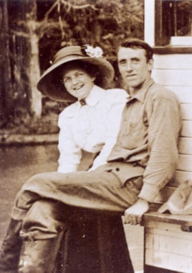
Jack and Sarah Waplington
https://search.heritageburnaby.ca/link/museumdescription5076
- Repository
- Burnaby Village Museum
- Date
- 1911
- Collection/Fonds
- Waplington family fonds
- Description Level
- Item
- Physical Description
- 1 photograph : col. copy print 13 x 9.5 cm
- Scope and Content
- Photograph of Jack and Sara Waplington who were married in 1911. Sarah is wearing a white blouse and a large hat with a floral corrsage on top while Jack is wearing a dark coloured shirt, pants and high topped boots. Both are seated outside an unidentified building.
- Repository
- Burnaby Village Museum
- Collection/Fonds
- Waplington family fonds
- Description Level
- Item
- Physical Description
- 1 photograph : col. copy print 13 x 9.5 cm
- Scope and Content
- Photograph of Jack and Sara Waplington who were married in 1911. Sarah is wearing a white blouse and a large hat with a floral corrsage on top while Jack is wearing a dark coloured shirt, pants and high topped boots. Both are seated outside an unidentified building.
- Geographic Access
- Deer Lake
- Deer Lake Avenue
- Accession Code
- BV016.46.53
- Access Restriction
- No restrictions
- Reproduction Restriction
- No known restrictions
- Date
- 1911
- Media Type
- Photograph
- Historic Neighbourhood
- Burnaby Lake (Historic Neighbourhood)
- Planning Study Area
- Morley-Buckingham Area
- Scan Resolution
- 600
- Scan Date
- 13-Aug-2018
- Notes
- Title based on contents of photograph
- Note in blue ink on verso of photograph reads: "Frances L's parents / Sara and Jack Waplington"
- Photograph is part of Photograph album BV016.46.52
Images