Narrow Results By
Decade
- 2020s 91
- 2010s 221
- 2000s
- 1990s
- 1980s
- 1970s 1266
- 1960s 595
- 1950s 463
- 1940s 357
- 1930s 357
- 1920s 537
- 1910s 362
- 1900s 139
- 1890s 73
- 1880s 27
- 1870s 10
- 1860s 21
- 1850s 8
- 1840s 4
- 1830s 2
- 1820s 2
- 1810s 3
- 1800s 3
- 1790s 3
- 1780s 3
- 1770s 3
- 1760s 3
- 1750s 3
- 1740s 3
- 1730s 3
- 1720s 3
- 1710s 3
- 1700s 3
- 1690s
- 1680s 3
- 1670s 2
- 1660s 2
- 1650s 2
- 1640s 2
- 1630s 2
- 1620s 2
- 1610s 2
- 1600s 2
- 1590s 1
- 1580s 1
- 1570s 1
- 1560s
- 1550s 1
- 1540s 1
- 1530s 1
- 1520s 2
- 1510s 1
- 1500s 1
- 1490s 1
- 1480s 1
6869 Canada Way C6-Zoned Property at Canada Way and Elwell Street
https://search.heritageburnaby.ca/link/councilreport14250
- Repository
- City of Burnaby Archives
- Report ID
- 8949
- Meeting Date
- 11-Jan-1988
- Format
- Council - Manager's Report
- Manager's Report No.
- 3
- Item No.
- 6
- Collection/Fonds
- City Council and Office of the City Clerk fonds
- Repository
- City of Burnaby Archives
- Report ID
- 8949
- Meeting Date
- 11-Jan-1988
- Format
- Council - Manager's Report
- Manager's Report No.
- 3
- Item No.
- 6
- Collection/Fonds
- City Council and Office of the City Clerk fonds
Documents
Assessment Roll Reductions for Canada Safeway, Sears Canada, and Burlington Northern Railway Properties
https://search.heritageburnaby.ca/link/councilreport5548
- Repository
- City of Burnaby Archives
- Report ID
- 61577
- Meeting Date
- 13-Jul-1998
- Format
- Council - Manager's Report
- Manager's Report No.
- 19
- Item No.
- 25
- Collection/Fonds
- City Council and Office of the City Clerk fonds
- Repository
- City of Burnaby Archives
- Report ID
- 61577
- Meeting Date
- 13-Jul-1998
- Format
- Council - Manager's Report
- Manager's Report No.
- 19
- Item No.
- 25
- Collection/Fonds
- City Council and Office of the City Clerk fonds
Documents
Development enquiry, Canadian Tire Company, Community Plan 8 Canada Way/Smith Avenue Area Apartment Study Area "I" (3841 Canada Way)
https://search.heritageburnaby.ca/link/councilreport18644
- Repository
- City of Burnaby Archives
- Report ID
- 2386
- Meeting Date
- 8-Feb-1982
- Format
- Council - Manager's Report
- Manager's Report No.
- 9
- Item No.
- 6
- Collection/Fonds
- City Council and Office of the City Clerk fonds
- Repository
- City of Burnaby Archives
- Report ID
- 2386
- Meeting Date
- 8-Feb-1982
- Format
- Council - Manager's Report
- Manager's Report No.
- 9
- Item No.
- 6
- Collection/Fonds
- City Council and Office of the City Clerk fonds
Documents
Development Inquiry, Community Plan 8 - Canada Way/Smith Avenue area Apartment Study Area "I" (3841 Canada Way) Canadian Tire
https://search.heritageburnaby.ca/link/councilreport18675
- Repository
- City of Burnaby Archives
- Report ID
- 2362
- Meeting Date
- 25-Jan-1982
- Format
- Council - Manager's Report
- Manager's Report No.
- 5
- Item No.
- 10
- Collection/Fonds
- City Council and Office of the City Clerk fonds
- Repository
- City of Burnaby Archives
- Report ID
- 2362
- Meeting Date
- 25-Jan-1982
- Format
- Council - Manager's Report
- Manager's Report No.
- 5
- Item No.
- 10
- Collection/Fonds
- City Council and Office of the City Clerk fonds
Documents
Proposed demolition of residential dwellings within Municipal Business Park 4547 and 4549 Canada Way (Northeast corner Canada Way and Willingdon Avenue)
https://search.heritageburnaby.ca/link/councilreport18108
- Repository
- City of Burnaby Archives
- Report ID
- 2921
- Meeting Date
- 8-Nov-1982
- Format
- Council - Manager's Report
- Manager's Report No.
- 62
- Item No.
- 3
- Collection/Fonds
- City Council and Office of the City Clerk fonds
- Repository
- City of Burnaby Archives
- Report ID
- 2921
- Meeting Date
- 8-Nov-1982
- Format
- Council - Manager's Report
- Manager's Report No.
- 62
- Item No.
- 3
- Collection/Fonds
- City Council and Office of the City Clerk fonds
Documents
Proposed Duplex Development - 5060 Canada Way - Canada Way/Clayton Avenue Area Plan
https://search.heritageburnaby.ca/link/councilreport5966
- Repository
- City of Burnaby Archives
- Report ID
- 61188
- Meeting Date
- 15-Dec-1997
- Format
- Council - Manager's Report
- Manager's Report No.
- 33
- Item No.
- 6
- Collection/Fonds
- City Council and Office of the City Clerk fonds
- Repository
- City of Burnaby Archives
- Report ID
- 61188
- Meeting Date
- 15-Dec-1997
- Format
- Council - Manager's Report
- Manager's Report No.
- 33
- Item No.
- 6
- Collection/Fonds
- City Council and Office of the City Clerk fonds
Documents
Proposed relocation of a bus shelter from westbound Canada Way east of Willingdon Avenue to eastbound Canada Way east of Sperling
https://search.heritageburnaby.ca/link/councilreport19636
- Repository
- City of Burnaby Archives
- Report ID
- 1383
- Meeting Date
- 15-Sep-1980
- Format
- Council - Manager's Report
- Manager's Report No.
- 58
- Item No.
- 1
- Collection/Fonds
- City Council and Office of the City Clerk fonds
- Repository
- City of Burnaby Archives
- Report ID
- 1383
- Meeting Date
- 15-Sep-1980
- Format
- Council - Manager's Report
- Manager's Report No.
- 58
- Item No.
- 1
- Collection/Fonds
- City Council and Office of the City Clerk fonds
Documents
Proposed sale and development of Municipal Lands N.E. quadrant - Canada Way and Willingdon Avenue - Rem. Lot 45 DL 70 Plan 56349 (4545 Canada Way)
https://search.heritageburnaby.ca/link/councilreport19655
- Repository
- City of Burnaby Archives
- Report ID
- 1368
- Meeting Date
- 8-Sep-1980
- Format
- Council - Manager's Report
- Manager's Report No.
- 56
- Item No.
- 3
- Collection/Fonds
- City Council and Office of the City Clerk fonds
- Repository
- City of Burnaby Archives
- Report ID
- 1368
- Meeting Date
- 8-Sep-1980
- Format
- Council - Manager's Report
- Manager's Report No.
- 56
- Item No.
- 3
- Collection/Fonds
- City Council and Office of the City Clerk fonds
Documents
Road Closure Reference #00-4 X-Ref: PPA #00-269 & Sub. #01-17 Closure of a ptn. Of the unopened 11th Avenue Road Allowance at Canada Way and dedication for the widening of Canada Way
https://search.heritageburnaby.ca/link/councilreport3757
- Repository
- City of Burnaby Archives
- Report ID
- 63387
- Meeting Date
- 9-Apr-2001
- Format
- Council - Manager's Report
- Manager's Report No.
- 11
- Item No.
- 5
- Collection/Fonds
- City Council and Office of the City Clerk fonds
- Repository
- City of Burnaby Archives
- Report ID
- 63387
- Meeting Date
- 9-Apr-2001
- Format
- Council - Manager's Report
- Manager's Report No.
- 11
- Item No.
- 5
- Collection/Fonds
- City Council and Office of the City Clerk fonds
Documents
Statistics Canada - Report on the Demographic Situation in Canada 1994 - Current Demographic Analysis
https://search.heritageburnaby.ca/link/archivedescription32060
- Repository
- City of Burnaby Archives
- Date
- 1994
- Collection/Fonds
- Planning Department fonds
- Description Level
- File
- Physical Description
- Textual record
- Repository
- City of Burnaby Archives
- Date
- 1994
- Collection/Fonds
- Planning Department fonds
- Physical Description
- Textual record
- Description Level
- File
- Record No.
- 35074
- Accession Number
- 2006-16
- Media Type
- Textual Record

South Burnaby Cenotaph
https://search.heritageburnaby.ca/link/landmark860
- Repository
- Burnaby Heritage Planning
- Description
- The South Burnaby Cenotaph is located in Bonsor Park at the corner of Nelson Avenue and Imperial Street. The cenotaph commemorates those lost in the First World War, Second World War and the Korean War.
- Associated Dates
- 1988
- Other Names
- Bonsor Park Cenotaph
- Street View URL
- Google Maps Street View
- Repository
- Burnaby Heritage Planning
- Other Names
- Bonsor Park Cenotaph
- Geographic Access
- Nelson Avenue
- Associated Dates
- 1988
- Description
- The South Burnaby Cenotaph is located in Bonsor Park at the corner of Nelson Avenue and Imperial Street. The cenotaph commemorates those lost in the First World War, Second World War and the Korean War.
- Historic Neighbourhood
- Central Park (Historic Neighbourhood)
- Planning Study Area
- Marlborough Area
- Community
- Burnaby
- Cadastral Identifier
- P.I.D. No. 027-719-375
- Boundaries
- The property (Bonsor Park) is comprised of a single municipally-owned property located at 6749 Nelson Avenue.
- Area
- 3570.00
- Contributing Resource
- Landscape Feature
- Structure
- Ownership
- Public (local)
- Street Address
- 6749 Nelson Avenue
- Street View URL
- Google Maps Street View
Images


Shadbolt Centre for the Arts
https://search.heritageburnaby.ca/link/landmark820
- Repository
- Burnaby Heritage Planning
- Geographic Access
- Deer Lake Avenue
- Associated Dates
- 1995
- Heritage Value
- The Shadbolt Centre for the Arts opened in 1995. The Shadbolt Centre was named after two Burnaby residents who dedicated a lifetime of support and cultivation of the arts locally, nationally and internationally. Doris and Jack Shadbolt resided in Burnaby for over 50 years until Jack's death in November 1998. Doris Shadbolt spent her life's work bringing the artist and the audience closer together through her writing and curatorial work. Jack Shadbolt was an internationally recognized Canadian painter. He was also an author and both received many awards including the Order of Canada. In keeping with the Shadbolts' generosity the arts, Jack Shadbolt donated two of his paintings to the Centre for permanent display.
- Historic Neighbourhood
- Burnaby Lake (Historic Neighbourhood)
- Planning Study Area
- Douglas-Gilpin Area
- Street Address
- 6450 Deer Lake Avenue
- Street View URL
- Google Maps Street View
Images

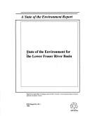
State of the environment for the Lower Fraser River Basin
https://search.heritageburnaby.ca/link/museumlibrary7450
- Repository
- Burnaby Village Museum
- Collection
- Reference Collection
- Material Type
- Textual Record
- ISBN
- 0662192346
- Call Number
- 363.7 SOE
- Place of Publication
- Ottawa, (Ont)
- Publisher
- Canada. Environment Canada.
- Publication Date
- c1992
- Physical Description
- 79 p. : ill., maps ; 22 x 28 cm.
- Library Subject (LOC)
- Environmental monitoring--Fraser River (B.C.)
- Environmental surveillance--Fraser River (B.C.)
- Environmental health--Fraser River (B.C.)
- Environmental monitoring--British Columbia
- Notes
- Co-published by the British Columbia Ministry of Environment, Lands and Parks.
- Includes bibliographical references.

Byrne Creek Secondary School
https://search.heritageburnaby.ca/link/landmark849
- Repository
- Burnaby Heritage Planning
- Geographic Access
- 18th Street
- Associated Dates
- 2005
- Heritage Value
- Byrne Creek School opened in 2005 and accommodates students from grades 8 through 12. When built, the school was created to house as many as 1200 students, but by 2009, plans have been prepared to increase that capacity to 1500.
- Historic Neighbourhood
- Edmonds (Historic Neighbourhood)
- Planning Study Area
- Stride Avenue Area
- Street Address
- 7777 18th Street
- Street View URL
- Google Maps Street View
Images


Douglas-Gilpin Neighbourhood
https://search.heritageburnaby.ca/link/landmark799
- Repository
- Burnaby Heritage Planning
- Associated Dates
- 1955-2008
- Heritage Value
- The Douglas-Gilpin Neighbourhood developed into a diverse area incorporating residential, business, educational and park districts in the period after 1955. The BCIT site was built in the early 1960s, shortly after the Burnaby Municipal Hall was located on Canada Way near Deer Lake in 1956. The construction of the Municipal Hall at this location fostered the creation of an administrative and business centre adjacent to the park, while the northern and central areas of the neighbourhood retained their primarily residential character.
- Historic Neighbourhood
- Burnaby Lake (Historic Neighbourhood)
- Planning Study Area
- Douglas-Gilpin Area
Images


Lake City Neighbourhood
https://search.heritageburnaby.ca/link/landmark793
- Repository
- Burnaby Heritage Planning
- Associated Dates
- 1955-2008
- Heritage Value
- When Simon Fraser University opened in 1965, approximately sixteen industrial properties had been developed in the Lake City Industrial Park. In addition, significant tracts of land in the western portion had been pre-cleared and graded in anticipation of additional development, while most of the eastern half remained forested. Some of the early companies to locate in the area were Nabob Foods, Volkswagen Canada, British Columbia Television Broadcasting, Simpson Sears, and H.Y. Louie Company Limited. Both Imperial Oil and Shell Oil established petroleum storage and distribution facilities in the area. Initially a heavy industrial area, by 1979, single family neighbourhoods south of Lougheed Highway and west of Eagle Creek had been largely developed. By the mid1980's, the Burnaby 200 multi-family development along Forest Grove Drive had also been completed.
- Planning Study Area
- Lake City Area
Images


Morley-Buckingham Neighbourhood
https://search.heritageburnaby.ca/link/landmark829
- Repository
- Burnaby Heritage Planning
- Associated Dates
- 1955-2008
- Heritage Value
- In the 1980 "Residential Neighbourhood Environment Study," the Morley-Buckingham Neighbourhood is described as "perhaps Burnaby's most prestigious residential area. The lots are larger than most other areas of the Municipality and this, along with the new expensive housing developed over the past 10 years, has created a very desirable residential neighbourhood...The older area of Buckingham lies at the lower edge of the slope and here the homes and streets are more uniform and aged between 20 and 25 years old...to the east of Canada Way lies...a cluster townhouse development."
- Historic Neighbourhood
- Burnaby Lake (Historic Neighbourhood)
- Planning Study Area
- Morley-Buckingham Area
Images


Willingdon Heights Neighbourhood
https://search.heritageburnaby.ca/link/landmark777
- Repository
- Burnaby Heritage Planning
- Associated Dates
- 1955-2008
- Heritage Value
- The convenient location of Willingdon Heights to the Trans Canada Highway, Lougheed Highway and Hastings Street has fostered its development as a primarily residential commuter neighbourhood. Characterised in the post-World War Two period by predominantly single-family developments, the neighbourhood has retained this identity despite some higher density apartment buildings now found there.
- Planning Study Area
- Willingdon Heights Area
Images

BHS Photo Discs by Sid Cumbers 2004
https://search.heritageburnaby.ca/link/archivedescription98460
- Repository
- City of Burnaby Archives
- Date
- 2000-2004
- Collection/Fonds
- Burnaby Historical Society fonds
- Description Level
- File
- Physical Description
- 205 photographs (jpgs and pdd) on 2 optical discs
- Scope and Content
- Photographs of various events in which the Burnaby Historical Society participated including bus trips, Christmas parties, 1223 interurban tram events, and Canada Day and other holiday celebrations.
- Repository
- City of Burnaby Archives
- Date
- 2000-2004
- Collection/Fonds
- Burnaby Historical Society fonds
- Series
- Administration series
- Physical Description
- 205 photographs (jpgs and pdd) on 2 optical discs
- Description Level
- File
- Record No.
- 633-015
- Access Restriction
- No restrictions
- Reproduction Restriction
- No restrictions
- Accession Number
- 2020-06
- Scope and Content
- Photographs of various events in which the Burnaby Historical Society participated including bus trips, Christmas parties, 1223 interurban tram events, and Canada Day and other holiday celebrations.
- Media Type
- Photograph
- Photographer
- Cumbers, Sidney
- Notes
- Transcribed title
- Title transcribed from original disc envelope
- Disc 2020-06-001 label reads: "Burnaby Historical Society 2004 / Content Description 1. BHS Bus Trip, 2000 2. BHS Xmas, 2001 3. BHS XMas, 2003 4. Canada Day, 2004 5. Victoria Day, 2004 6. Tram1223, 2001-2004 7. Tram1223BBQ, 2004 8. Tram1223 Volunteers, 2004:
- Disc 2020-06-002 label reads: "Burnaby Village Museum Labour Day Fair / Monday September 6, 2004"
- Contact sheet for photographs on 2020-06-001 available in accession file.
Images
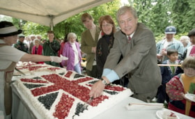
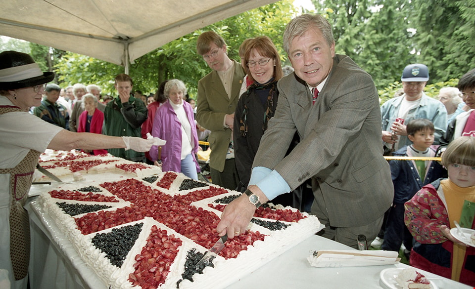
Burnaby Mayor Doug Drummond cutting Union Jack cake at Canada Day event
https://search.heritageburnaby.ca/link/museumdescription16572
- Repository
- Burnaby Village Museum
- Date
- July 1997
- Collection/Fonds
- Burnaby Village Museum fonds
- Description Level
- Item
- Physical Description
- 1 photograph : col. negative ; 35 mm
- Scope and Content
- Photograph of Burnaby Mayor Doug Drummond cutting into a sheet cake decorated with a Union Jack flag at Burnaby Village Museum during a Canada Day event.
- Repository
- Burnaby Village Museum
- Collection/Fonds
- Burnaby Village Museum fonds
- Description Level
- Item
- Physical Description
- 1 photograph : col. negative ; 35 mm
- Scope and Content
- Photograph of Burnaby Mayor Doug Drummond cutting into a sheet cake decorated with a Union Jack flag at Burnaby Village Museum during a Canada Day event.
- Accession Code
- BV020.4.924
- Access Restriction
- No restrictions
- Reproduction Restriction
- May be restricted by third party rights
- Date
- July 1997
- Media Type
- Photograph
- Scan Resolution
- 2400
- Scan Date
- 19-Jan-2021
- Photographer
- Relke, Chris
- Notes
- Title based on contents of photograph
- 1 col. contact sheet accompanying negative
Images