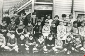
![Inman Avenue school children, [192-] (date of original), copied 1992 thumbnail](/media/hpo/_Data/_Archives_Images/_Unrestricted/315/315-084.jpg?width=280)
Inman Avenue school children
https://search.heritageburnaby.ca/link/archivedescription36729
- Repository
- City of Burnaby Archives
- Date
- [192-] (date of original), copied 1992
- Collection/Fonds
- Burnaby Historical Society fonds
- Description Level
- Item
- Physical Description
- 1 photograph : b&w ; 8.2 x 11.1 cm print
- Scope and Content
- Photograph of a group of school children, likely from Inman Avenue School.
- Repository
- City of Burnaby Archives
- Date
- [192-] (date of original), copied 1992
- Collection/Fonds
- Burnaby Historical Society fonds
- Subseries
- Burnaby Centennial Anthology subseries
- Physical Description
- 1 photograph : b&w ; 8.2 x 11.1 cm print
- Description Level
- Item
- Record No.
- 315-084
- Access Restriction
- No restrictions
- Reproduction Restriction
- No known restrictions
- Accession Number
- BHS1994-04
- Scope and Content
- Photograph of a group of school children, likely from Inman Avenue School.
- Names
- Inman Avenue School
- Media Type
- Photograph
- Notes
- Title based on contents of photograph
- Geographic Access
- Brandon Street
- Street Address
- 3963 Brandon Street
- Historic Neighbourhood
- Central Park (Historic Neighbourhood)
- Planning Study Area
- Garden Village Area
Images
![Inman Avenue school children, [192-] (date of original), copied 1992 thumbnail](/media/hpo/_Data/_Archives_Images/_Unrestricted/315/315-084.jpg)
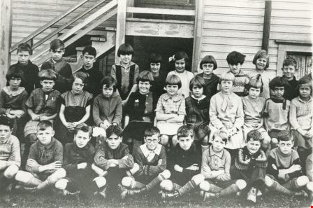
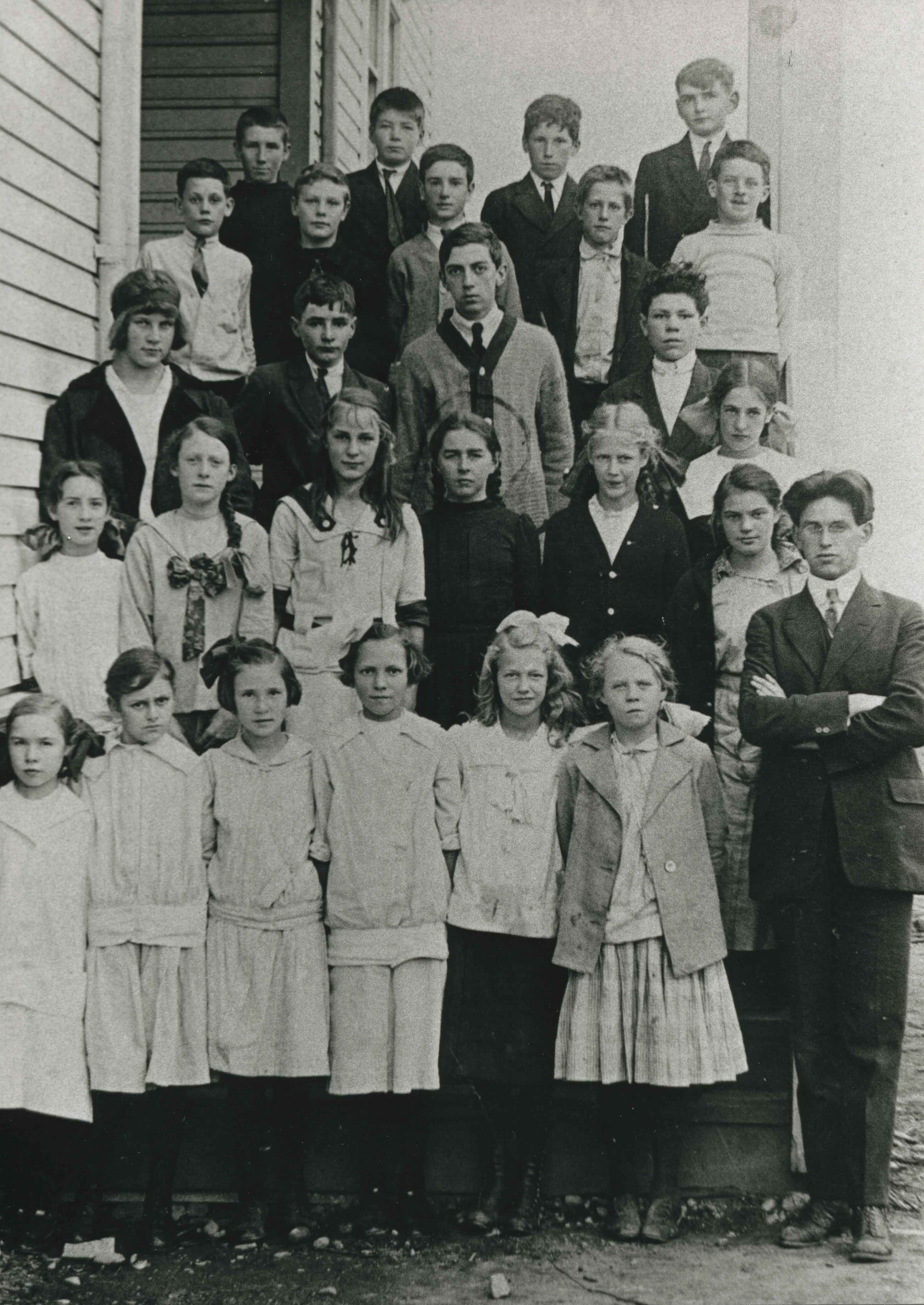
Inman Avenue School class
https://search.heritageburnaby.ca/link/archivedescription35232
- Repository
- City of Burnaby Archives
- Date
- 1928 (date of original), copied 1986
- Collection/Fonds
- Burnaby Historical Society fonds
- Description Level
- Item
- Physical Description
- 1 photograph : b&w ; 12.7 x 17.8 cm print
- Scope and Content
- Photograph of Inman Avenue School students. Grace Farrington is in the 2nd row, 5th from left, next to the girl in the checked dress.
- Repository
- City of Burnaby Archives
- Date
- 1928 (date of original), copied 1986
- Collection/Fonds
- Burnaby Historical Society fonds
- Subseries
- Pioneer Tales subseries
- Physical Description
- 1 photograph : b&w ; 12.7 x 17.8 cm print
- Description Level
- Item
- Record No.
- 204-089
- Access Restriction
- No restrictions
- Reproduction Restriction
- No known restrictions
- Accession Number
- BHS1988-03
- Scope and Content
- Photograph of Inman Avenue School students. Grace Farrington is in the 2nd row, 5th from left, next to the girl in the checked dress.
- Media Type
- Photograph
- Notes
- Title based on contents of photograph
- Geographic Access
- Brandon Street
- Street Address
- 3963 Brandon Street
- Historic Neighbourhood
- Central Park (Historic Neighbourhood)
- Planning Study Area
- Garden Village Area
Images

Inman Avenue School site
https://search.heritageburnaby.ca/link/museumdescription11128
- Repository
- Burnaby Village Museum
- Date
- May 3, 1915
- Collection/Fonds
- Ronald G. Scobbie collection
- Description Level
- Item
- Physical Description
- 1 survey plan : blueprint on paper ; 56 x 54 cm
- Scope and Content
- Survey plan of "Inman Avenue School Site" "Burnaby Municipality" "Being Lots 3 -12 inc. Blk. C. of Subd. of Blks.5" "13-19 inc. & 21-28 inc. of Subd. of Westerly 80 Acres of, and portion of D.L. 34, Group One. New Westminster District".
- Repository
- Burnaby Village Museum
- Collection/Fonds
- Ronald G. Scobbie collection
- Description Level
- Item
- Physical Description
- 1 survey plan : blueprint on paper ; 56 x 54 cm
- Material Details
- Scale: 40 feet = 1 inch
- Scope and Content
- Survey plan of "Inman Avenue School Site" "Burnaby Municipality" "Being Lots 3 -12 inc. Blk. C. of Subd. of Blks.5" "13-19 inc. & 21-28 inc. of Subd. of Westerly 80 Acres of, and portion of D.L. 34, Group One. New Westminster District".
- Creator
- McGugan, Donald Johnston
- Subjects
- Buildings - Schools
- Names
- Inman Avenue School
- Responsibility
- Burnett & McGugan, Engineers and Surveyors
- Geographic Access
- Brandon Street
- Street Address
- 3963 Brandon Street
- Accession Code
- BV003.83.7
- Access Restriction
- No restrictions
- Reproduction Restriction
- No known restrictions
- Date
- May 3, 1915
- Media Type
- Cartographic Material
- Historic Neighbourhood
- Central Park (Historic Neighbourhood)
- Planning Study Area
- Garden Village Area
- Scan Resolution
- 440
- Scan Date
- 22-Dec-2020
- Scale
- 100
- Notes
- Title based on contents of plan
- Oath in bottom left corner reads: "I, D.J. McGugan...did...superintend the survey...", "...completed on the 3rd day of May 1915"; signed "D.J. McGugan", notariz- ed by "Walter Edmonds" "sworn...22nd Day of May 1915"; "Burnett and McGugan. B.C. Land Surveyors. Etc. New Westminster. B.C.";
- handwritten note reads: "Note: Before using this Mon. see plan / of resubdivision of Lots 5 & 6 / of Block 'B' D.L. 34 / June 1945"
- handwritten twice on back, "1776"
Zoomable Images

Inman, Burnaby, B.C.
https://search.heritageburnaby.ca/link/archivedescription66388
- Repository
- City of Burnaby Archives
- Date
- 1954
- Collection/Fonds
- Grieve family fonds
- Description Level
- Item
- Physical Description
- 1 photograph : b&w ; 11.5 x 16.5 cm
- Scope and Content
- Photograph of the exterior of Inman Avenue School.
- Repository
- City of Burnaby Archives
- Date
- 1954
- Collection/Fonds
- Grieve family fonds
- Physical Description
- 1 photograph : b&w ; 11.5 x 16.5 cm
- Description Level
- Item
- Record No.
- 523-002
- Access Restriction
- No restrictions
- Reproduction Restriction
- No known restrictions
- Accession Number
- 2011-04
- Scope and Content
- Photograph of the exterior of Inman Avenue School.
- Subjects
- Buildings - Schools
- Names
- Inman Avenue School
- Media Type
- Photograph
- Notes
- Title based on contents of photograph
- Photographer's writing (engraved on negative) reads: "Layton / Inman. Burnaby, B.C. / 1954"
- Geographic Access
- Brandon Street
- Street Address
- 3963 Brandon Street
- Historic Neighbourhood
- Central Park (Historic Neighbourhood)
- Planning Study Area
- Garden Village Area
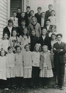
Inman School Class
https://search.heritageburnaby.ca/link/archivedescription35218
- Repository
- City of Burnaby Archives
- Date
- 1912 (date of original), copied 1986
- Collection/Fonds
- Burnaby Historical Society fonds
- Description Level
- Item
- Physical Description
- 1 photograph : b&w ; 12.7 x 17.8 cm print
- Scope and Content
- Photograph of Inman Avenue School class. Marjorie Cassidy is in the 2nd row, 4th from left. The teacher, to the right, is Mr. Lowther. The Cassidy children, from oldest, are Willie, Marjorie, Mary and Katie.
- Repository
- City of Burnaby Archives
- Date
- 1912 (date of original), copied 1986
- Collection/Fonds
- Burnaby Historical Society fonds
- Subseries
- Pioneer Tales subseries
- Physical Description
- 1 photograph : b&w ; 12.7 x 17.8 cm print
- Description Level
- Item
- Record No.
- 204-075
- Access Restriction
- No restrictions
- Reproduction Restriction
- No known restrictions
- Accession Number
- BHS1988-03
- Scope and Content
- Photograph of Inman Avenue School class. Marjorie Cassidy is in the 2nd row, 4th from left. The teacher, to the right, is Mr. Lowther. The Cassidy children, from oldest, are Willie, Marjorie, Mary and Katie.
- Subjects
- Occupations - Teachers
- Media Type
- Photograph
- Notes
- Title based on contents of photograph
- Geographic Access
- Brandon Street
- Street Address
- 3963 Brandon Street
- Historic Neighbourhood
- Central Park (Historic Neighbourhood)
- Planning Study Area
- Garden Village Area
Images

Janet Shankie
https://search.heritageburnaby.ca/link/archivedescription35146
- Repository
- City of Burnaby Archives
- Date
- 1931 (date of original), copied 1986
- Collection/Fonds
- Burnaby Historical Society fonds
- Description Level
- Item
- Physical Description
- 1 photograph : b&w ; 12.7 x 17.8 cm print
- Scope and Content
- Photograph of Janet Bower (nee Shankie) in Scottish regalia. The house was formerly numbered 3718 Barker Avenue and later renumbered 5155 Barker Avenue.
- Repository
- City of Burnaby Archives
- Date
- 1931 (date of original), copied 1986
- Collection/Fonds
- Burnaby Historical Society fonds
- Subseries
- Pioneer Tales subseries
- Physical Description
- 1 photograph : b&w ; 12.7 x 17.8 cm print
- Description Level
- Item
- Record No.
- 204-003
- Access Restriction
- No restrictions
- Reproduction Restriction
- No known restrictions
- Accession Number
- BHS1988-03
- Scope and Content
- Photograph of Janet Bower (nee Shankie) in Scottish regalia. The house was formerly numbered 3718 Barker Avenue and later renumbered 5155 Barker Avenue.
- Subjects
- Clothing
- Names
- Bower, Janet Shankie
- Media Type
- Photograph
- Notes
- Title based on contents of photograph
- Geographic Access
- Barker Avenue
- Street Address
- 5155 Barker Avenue
- Historic Neighbourhood
- Central Park (Historic Neighbourhood)
- Planning Study Area
- Garden Village Area
Images

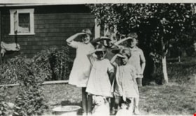
Janet Shankie and friends
https://search.heritageburnaby.ca/link/archivedescription35147
- Repository
- City of Burnaby Archives
- Date
- 1927 (date of original), copied 1986
- Collection/Fonds
- Burnaby Historical Society fonds
- Description Level
- Item
- Physical Description
- 1 photograph : b&w ; 12.7 x 17.8 cm print
- Scope and Content
- Photograph of Janet Shankie (front right) with brother Thomas Ramsay Hunter Shankie (back right) and neighbourhood friends: Margaret, Tom and Betty. The house was formerly numbered 3718 Barker Avenue and later renumbered 5155 Barker Avenue.
- Repository
- City of Burnaby Archives
- Date
- 1927 (date of original), copied 1986
- Collection/Fonds
- Burnaby Historical Society fonds
- Subseries
- Pioneer Tales subseries
- Physical Description
- 1 photograph : b&w ; 12.7 x 17.8 cm print
- Description Level
- Item
- Record No.
- 204-004
- Access Restriction
- No restrictions
- Reproduction Restriction
- No known restrictions
- Accession Number
- BHS1988-03
- Scope and Content
- Photograph of Janet Shankie (front right) with brother Thomas Ramsay Hunter Shankie (back right) and neighbourhood friends: Margaret, Tom and Betty. The house was formerly numbered 3718 Barker Avenue and later renumbered 5155 Barker Avenue.
- Subjects
- Toys - Dolls
- Media Type
- Photograph
- Notes
- Title based on contents of photograph
- Geographic Access
- Barker Avenue
- Street Address
- 5155 Barker Avenue
- Historic Neighbourhood
- Central Park (Historic Neighbourhood)
- Planning Study Area
- Garden Village Area
Images
![Kathy Hardy, [ca. 1955] thumbnail](/media/hpo/_Data/_BVM_Images/2015/2015_0036_0115_001.jpg?width=280)
Kathy Hardy
https://search.heritageburnaby.ca/link/museumdescription4967
- Repository
- Burnaby Village Museum
- Date
- [ca. 1955]
- Collection/Fonds
- Burnaby Girl Guides fonds
- Description Level
- Item
- Physical Description
- 1 photograph : b&w ; 10 x 7 cm
- Scope and Content
- Photograph of Kathyrn "Kathy" Raadsheer (nee Hardy) dressed in her Brownie uniform standing outside a house which could be her family home located at 4337 Wildwood Cresent Burnaby.
- Repository
- Burnaby Village Museum
- Collection/Fonds
- Burnaby Girl Guides fonds
- Description Level
- Item
- Physical Description
- 1 photograph : b&w ; 10 x 7 cm
- Scope and Content
- Photograph of Kathyrn "Kathy" Raadsheer (nee Hardy) dressed in her Brownie uniform standing outside a house which could be her family home located at 4337 Wildwood Cresent Burnaby.
- Geographic Access
- Wildwood Crescent
- Street Address
- 4337 Wildwood Crescent
- Accession Code
- BV015.36.115
- Access Restriction
- No restrictions
- Reproduction Restriction
- May be restricted by third party rights
- Date
- [ca. 1955]
- Media Type
- Photograph
- Historic Neighbourhood
- Central Park (Historic Neighbourhood)
- Planning Study Area
- Garden Village Area
- Arrangement
- Photographs and slides were arranged by Kathyrn Raadsheer (nee Hardy)
- Scan Resolution
- 600
- Scan Date
- March 10, 2021
- Scale
- 100
- Notes
- Title based on contents of photograph
- Photograph is part of scrapbook (page 2/10) BV015.36.82.
Images
![Kathy Hardy, [ca. 1955] thumbnail](/media/hpo/_Data/_BVM_Images/2015/2015_0036_0115_001.jpg)

Kingsway
https://search.heritageburnaby.ca/link/archivedescription34510
- Repository
- City of Burnaby Archives
- Date
- 1920
- Collection/Fonds
- Burnaby Historical Society fonds
- Description Level
- Item
- Physical Description
- 1 photograph : sepia ; 12.6 x 17.7 cm
- Scope and Content
- Photograph of Kingsway looking east at Boundary Road. A sign on the right reads, "Burnaby / Vehicles must slow down at all schools and intersections marked thus: X." A sign on a building at the left reads, "Arctic Ice Cream." Central Park is on the right.
- Repository
- City of Burnaby Archives
- Date
- 1920
- Collection/Fonds
- Burnaby Historical Society fonds
- Subseries
- Photographs subseries
- Physical Description
- 1 photograph : sepia ; 12.6 x 17.7 cm
- Description Level
- Item
- Record No.
- 031-001
- Access Restriction
- No restrictions
- Reproduction Restriction
- No known restrictions
- Accession Number
- BHS2007-04
- Scope and Content
- Photograph of Kingsway looking east at Boundary Road. A sign on the right reads, "Burnaby / Vehicles must slow down at all schools and intersections marked thus: X." A sign on a building at the left reads, "Arctic Ice Cream." Central Park is on the right.
- Media Type
- Photograph
- Notes
- Title based on contents of photograph
- Geographic Access
- Kingsway
- Central Park
- Boundary Road
- Historic Neighbourhood
- Central Park (Historic Neighbourhood)
- Planning Study Area
- Garden Village Area
- Maywood Area
Images


Kingsway
https://search.heritageburnaby.ca/link/archivedescription34511
- Repository
- City of Burnaby Archives
- Date
- 1920
- Collection/Fonds
- Burnaby Historical Society fonds
- Description Level
- Item
- Physical Description
- 1 photograph : sepia ; 12.6 x 17.6 cm
- Scope and Content
- Photograph of Kingsway looking east at Boundary Road. A sign on the right reads, "Burnaby / Vehicles must slow down at all schools and intersections marked thus: X." A sign on a building at the left reads, "Arctic Ice Cream." Central Park is on the right.
- Repository
- City of Burnaby Archives
- Date
- 1920
- Collection/Fonds
- Burnaby Historical Society fonds
- Subseries
- Photographs subseries
- Physical Description
- 1 photograph : sepia ; 12.6 x 17.6 cm
- Description Level
- Item
- Record No.
- 031-002
- Access Restriction
- No restrictions
- Reproduction Restriction
- No known restrictions
- Accession Number
- BHS2007-04
- Scope and Content
- Photograph of Kingsway looking east at Boundary Road. A sign on the right reads, "Burnaby / Vehicles must slow down at all schools and intersections marked thus: X." A sign on a building at the left reads, "Arctic Ice Cream." Central Park is on the right.
- Subjects
- Geographic Features - Roads
- Advertising Medium - Signs and Signboards
- Transportation - Automobiles
- Media Type
- Photograph
- Notes
- Title based on contents of photograph
- Geographic Access
- Kingsway
- Central Park
- Boundary Road
- Historic Neighbourhood
- Central Park (Historic Neighbourhood)
- Planning Study Area
- Garden Village Area
- Maywood Area
Images


Kingsway
https://search.heritageburnaby.ca/link/archivedescription35874
- Repository
- City of Burnaby Archives
- Date
- 1900 (date of original), copied 1986
- Collection/Fonds
- Burnaby Historical Society fonds
- Description Level
- Item
- Physical Description
- 1 photograph : b&w ; 12.7 x 17.8 cm print
- Scope and Content
- Photograph of Kingsway (then Westminster Road), looking east from Boundary Road near Central Park. Included in the photograph; Central Park Presbyterian Church, Masonic Hall and Reid's Hall.
- Repository
- City of Burnaby Archives
- Date
- 1900 (date of original), copied 1986
- Collection/Fonds
- Burnaby Historical Society fonds
- Subseries
- Pioneer Tales subseries
- Physical Description
- 1 photograph : b&w ; 12.7 x 17.8 cm print
- Description Level
- Item
- Record No.
- 204-733
- Access Restriction
- No restrictions
- Reproduction Restriction
- No known restrictions
- Accession Number
- BHS1988-03
- Scope and Content
- Photograph of Kingsway (then Westminster Road), looking east from Boundary Road near Central Park. Included in the photograph; Central Park Presbyterian Church, Masonic Hall and Reid's Hall.
- Subjects
- Buildings - Recreational - Community Halls
- Buildings - Religious - Churches
- Geographic Features - Roads
- Media Type
- Photograph
- Notes
- Title based on contents of photograph
- Geographic Access
- Westminster Avenue
- Kingsway
- Street Address
- 3777 Kingsway
- Historic Neighbourhood
- Central Park (Historic Neighbourhood)
- Planning Study Area
- Garden Village Area
Images

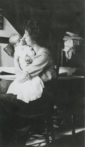
Mrs. King and baby Annie
https://search.heritageburnaby.ca/link/archivedescription37773
- Repository
- City of Burnaby Archives
- Date
- 1920 (date of original), copied 1991
- Collection/Fonds
- Burnaby Historical Society fonds
- Description Level
- Item
- Physical Description
- 1 photograph : b&w ; 4.2 x 2.4 cm print on contact sheet 20.3 x 26.2 cm
- Scope and Content
- Photograph of Mrs. King holding her daughter, Annie, inside the Clarke house on Inman Avenue.
- Repository
- City of Burnaby Archives
- Date
- 1920 (date of original), copied 1991
- Collection/Fonds
- Burnaby Historical Society fonds
- Subseries
- Burnaby Image Bank subseries
- Physical Description
- 1 photograph : b&w ; 4.2 x 2.4 cm print on contact sheet 20.3 x 26.2 cm
- Description Level
- Item
- Record No.
- 370-361
- Access Restriction
- No restrictions
- Reproduction Restriction
- No known restrictions
- Accession Number
- BHS1999-03
- Scope and Content
- Photograph of Mrs. King holding her daughter, Annie, inside the Clarke house on Inman Avenue.
- Subjects
- Furniture
- Names
- Ellis, Annie King
- Media Type
- Photograph
- Notes
- Title based on contents of photograph
- 1 b&w copy negative accompanying
- Negative has a pink cast
- Geographic Access
- Inman Avenue
- Historic Neighbourhood
- Central Park (Historic Neighbourhood)
- Planning Study Area
- Garden Village Area
Images


Municipality of Burnaby - Volume XVI and Volume XVII
https://search.heritageburnaby.ca/link/museumdescription8684
- Repository
- Burnaby Village Museum
- Date
- May 1927
- Collection/Fonds
- Burnaby Village Museum Map collection
- Description Level
- File
- Physical Description
- 4 plans on 4 sheets : col. lithographic prints ; 63.5 x 53.5 cm folded to 53 x 31.5 cm
- Scope and Content
- File consists of four pages of plans removed from a bound book containing a series of fire insurance plans of the Municipality of Burnaby. Page "D" is titled: "GREATER VANCOUVER B.C. / VOLUME XVI / Surveyed _ May 1927 / MUNICIPALITY OF / BURNABY / PLAN DEPT. FIRE BRANCH _ B.C. INSURANCE UNDERWRITE…
- Repository
- Burnaby Village Museum
- Collection/Fonds
- Burnaby Village Museum Map collection
- Description Level
- File
- Physical Description
- 4 plans on 4 sheets : col. lithographic prints ; 63.5 x 53.5 cm folded to 53 x 31.5 cm
- Material Details
- Scale [1:1200] and [1:6000]
- Scope and Content
- File consists of four pages of plans removed from a bound book containing a series of fire insurance plans of the Municipality of Burnaby. Page "D" is titled: "GREATER VANCOUVER B.C. / VOLUME XVI / Surveyed _ May 1927 / MUNICIPALITY OF / BURNABY / PLAN DEPT. FIRE BRANCH _ B.C. INSURANCE UNDERWRITERS ASSN." / KEY PLAN". Plans covered in this "Key Plan" are numbered 1601 to 1626, 1632 and 1651 covering District Lots: 15; 31; 100 to 102; 114; 141 to 144; 147 and 148; 209 to 214. Plan "E" is part of "GREATER VANCOUVER B.C. / VOLUME XVII / Municipality of Burnaby / May 1927" and covers plans: 1701 to 1705; 1711 to 1715; 1723 to 1727; 1729 to 1733; 1737 to 1742 and District Lots: 68 to 74; 80 to 84; 32 to 35 and 38 to 39. Plan marked "F" is a key plan titled: "GREATER VANCOUVER B.C. / VOLUME XVII / Surveyed _ May 1927 / MUNICIPALITY OF / BURNABY and covers plans: 1706 to 1710; 1716 to 1722; 1734 and 1735; 1743 to 1752 and District Lots: 42 to 44; 59; 75 to 80; 83 to 87; 89 to 93 and 130. Plan "1729" is part of "GREATER VANCOUVER B.C. / VOLUME XVII / Municipality of Burnaby / May 1927" and covers District Lots 34 and 35.
- Responsibility
- British Columbia Underwriters' Association
- Accession Code
- HV972.111.6
- Access Restriction
- No restrictions
- Reproduction Restriction
- May be restricted by third party rights
- Date
- May 1927
- Media Type
- Cartographic Material
- Historic Neighbourhood
- Barnet (Historic Neighbourhood)
- Burquitlam (Historic Neighbourhood)
- Central Park (Historic Neighbourhood)
- Burnaby Lake (Historic Neighbourhood)
- Broadview (Historic Neighbourhood)
- Planning Study Area
- Burnaby Mountain Area
- Lyndhurst Area
- Lake City Area
- Cascade-Schou Area
- Garden Village Area
- Douglas-Gilpin Area
- Oakalla Area
- Scan Resolution
- 400
- Scan Date
- 2021-11-18
- Notes
- Title based on content of plans
- See also BV987.1.70d for revised versions of plans
- Scale is measured 1 inch = 500 feet
Zoomable Images


Municipality of Burnaby - Volume XV, Volume XVI, Volume XVII, Volume XVIII
https://search.heritageburnaby.ca/link/museumdescription8685
- Repository
- Burnaby Village Museum
- Date
- May 1927
- Collection/Fonds
- Burnaby Village Museum Map collection
- Description Level
- File
- Physical Description
- 4 plans on 4 sheets : col. lithographic prints ; 63.5 x 53.5 cm folded to 53 x 31.5 cm
- Scope and Content
- File consists of four pages of plans removed from a bound book containing a series of fire insurance plans of the Municipality of Burnaby. Plan "1531" is part of "GREATER VANCOUVER B.C. / VOLUME XV / Municipality of Burnaby / May 1927" and covers District Lots: 116 and 117. Key Plan "C" is part of …
- Repository
- Burnaby Village Museum
- Collection/Fonds
- Burnaby Village Museum Map collection
- Description Level
- File
- Physical Description
- 4 plans on 4 sheets : col. lithographic prints ; 63.5 x 53.5 cm folded to 53 x 31.5 cm
- Material Details
- Scale [1:600] and [1:1200]
- Scope and Content
- File consists of four pages of plans removed from a bound book containing a series of fire insurance plans of the Municipality of Burnaby. Plan "1531" is part of "GREATER VANCOUVER B.C. / VOLUME XV / Municipality of Burnaby / May 1927" and covers District Lots: 116 and 117. Key Plan "C" is part of "GREATER VANCOUVER B.C. / VOLUME XVI / Municipality of Burnaby / May 1927" and covers plans 1623 to 1651 and District Lots: 1 and 2; 4; 6; 8; 10 to 14; 25; 27; 40; 56 to 58; 88 and 89. Plan "1738" is part of "GREATER VANCOUVER B.C. / VOLUME XVII / Municipality of Burnaby / May 1927" and covers District Lots: 34 and 35. Key plan "G" is part of "GREATER VANCOUVER B.C. / VOLUME XVIII / Municipality of Burnaby / May 1927" and covers plans: 1801 to 1813; 1823; 1824; 1833 to 1838; 1841 to 1853 and District Lots: 32; 93; 94; 97 to 99; 149; 150; 152; 155 to 159; 161 to 164.
- Responsibility
- British Columbia Underwriters' Association
- Accession Code
- HV972.111.7
- Access Restriction
- No restrictions
- Reproduction Restriction
- May be restricted by third party rights
- Date
- May 1927
- Media Type
- Cartographic Material
- Historic Neighbourhood
- Central Park (Historic Neighbourhood)
- Fraser Arm (Historic Neighbourhood)
- Alta Vista (Historic Neighbourhood)
- Broadview (Historic Neighbourhood)
- Vancouver Heights (Historic Neighbourhood)
- Burquitlam (Historic Neighbourhood)
- East Burnaby (Historic Neighbourhood)
- Edmonds (Historic Neighbourhood)
- Lozells (Historic Neighbourhood)
- Planning Study Area
- Clinton-Glenwood Area
- Marlborough Area
- Maywood Area
- Windsor Area
- Big Bend Area
- Garden Village Area
- Willingdon Heights Area
- West Central Valley Area
- Cariboo-Armstrong Area
- Lyndhurst Area
- Cameron Area
- Lake City Area
- Edmonds Area
- Second Street Area
- Sperling-Broadway Area
- Lakeview-Mayfield Area
- Scan Resolution
- 400
- Scan Date
- 2021-11-18
- Notes
- Title based on content of plans
- See also BV987.1.70d for revised versions of plans
- Scale is measured 1 inch = 500 feet
Zoomable Images

Municipality of Burnaby - Volume XV, Volume XVI, Volume XVII, Volume XVIII, May 1927
Zoom into Image

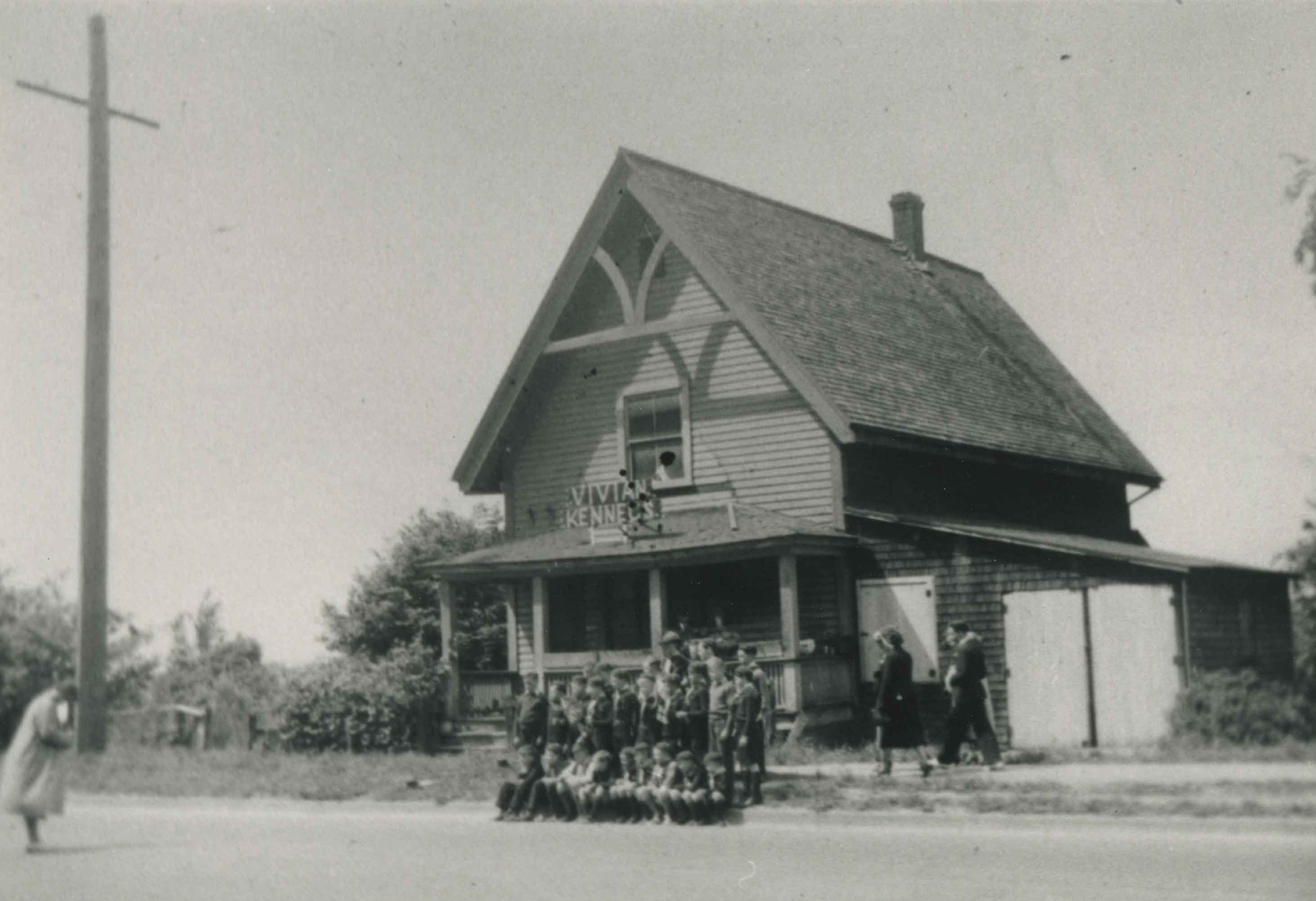
Old Presbyterian Church
https://search.heritageburnaby.ca/link/archivedescription38245
- Repository
- City of Burnaby Archives
- Date
- 1939
- Collection/Fonds
- Burnaby Historical Society fonds
- Description Level
- Item
- Physical Description
- 1 photograph : b&w ; 9 x 12.5 cm
- Scope and Content
- Photograph of approximately thirty young people posing for a picture on the sidewalk outside what has been labelled the old Presbyterian Church located at Kingsway, east of Boundary Road. A sign on the roof of the building reads "Vivian Kennels."
- Repository
- City of Burnaby Archives
- Date
- 1939
- Collection/Fonds
- Burnaby Historical Society fonds
- Subseries
- Margaret McCallum subseries
- Physical Description
- 1 photograph : b&w ; 9 x 12.5 cm
- Description Level
- Item
- Record No.
- 375-006
- Access Restriction
- No restrictions
- Reproduction Restriction
- No known restrictions
- Accession Number
- BHS1986-42
- Scope and Content
- Photograph of approximately thirty young people posing for a picture on the sidewalk outside what has been labelled the old Presbyterian Church located at Kingsway, east of Boundary Road. A sign on the roof of the building reads "Vivian Kennels."
- Subjects
- Buildings - Religious - Churches
- Media Type
- Photograph
- Notes
- Title based on contents of photograph
- Geographic Access
- Kingsway
- Historic Neighbourhood
- Central Park (Historic Neighbourhood)
- Planning Study Area
- Garden Village Area
Images
Olive Farrington
https://search.heritageburnaby.ca/link/archivedescription35230
- Repository
- City of Burnaby Archives
- Date
- 1919 (date of original), copied 1986
- Collection/Fonds
- Burnaby Historical Society fonds
- Description Level
- Item
- Physical Description
- 1 photograph : b&w ; 12.7 x 17.8 cm print
- Scope and Content
- Photograph of the Farrington family home at Bond Street and Chisholm Avenue (now Smith Avenue). Olive Farrington is standing in front, centre, with two friends.
- Repository
- City of Burnaby Archives
- Date
- 1919 (date of original), copied 1986
- Collection/Fonds
- Burnaby Historical Society fonds
- Subseries
- Pioneer Tales subseries
- Physical Description
- 1 photograph : b&w ; 12.7 x 17.8 cm print
- Description Level
- Item
- Record No.
- 204-087
- Access Restriction
- No restrictions
- Reproduction Restriction
- No known restrictions
- Accession Number
- BHS1988-03
- Scope and Content
- Photograph of the Farrington family home at Bond Street and Chisholm Avenue (now Smith Avenue). Olive Farrington is standing in front, centre, with two friends.
- Names
- Barber, Olive Farrington
- Media Type
- Photograph
- Notes
- Title based on contents of photograph
- Geographic Access
- Bond Street
- Smith Avenue
- Historic Neighbourhood
- Central Park (Historic Neighbourhood)
- Planning Study Area
- Garden Village Area
Images


Olive Farrington Barber
https://search.heritageburnaby.ca/link/archivedescription35225
- Repository
- City of Burnaby Archives
- Date
- 1928 (date of original), copied 1986
- Collection/Fonds
- Burnaby Historical Society fonds
- Description Level
- Item
- Physical Description
- 1 photograph : b&w ; 12.7 x 17.8 cm print
- Scope and Content
- Photograph of Olive Farrington Barber in front of the Farrington brothers' chicken shed. Brothers Thomas Farrington and Richard Farrington founded Wheat Sheaf Poultry Ranch in 1919. It was located at 3907 Chesham Avenue (later renumbered 5384 Chesham Avenue).
- Repository
- City of Burnaby Archives
- Date
- 1928 (date of original), copied 1986
- Collection/Fonds
- Burnaby Historical Society fonds
- Subseries
- Pioneer Tales subseries
- Physical Description
- 1 photograph : b&w ; 12.7 x 17.8 cm print
- Description Level
- Item
- Record No.
- 204-082
- Access Restriction
- No restrictions
- Reproduction Restriction
- No known restrictions
- Accession Number
- BHS1988-03
- Scope and Content
- Photograph of Olive Farrington Barber in front of the Farrington brothers' chicken shed. Brothers Thomas Farrington and Richard Farrington founded Wheat Sheaf Poultry Ranch in 1919. It was located at 3907 Chesham Avenue (later renumbered 5384 Chesham Avenue).
- Media Type
- Photograph
- Notes
- Title based on contents of photograph
- Geographic Access
- Chesham Avenue
- Street Address
- 5384 Chesham Avenue
- Historic Neighbourhood
- Central Park (Historic Neighbourhood)
- Planning Study Area
- Garden Village Area
Images


One person per household
https://search.heritageburnaby.ca/link/archivedescription95109
- Repository
- City of Burnaby Archives
- Date
- April 27, 2020
- Collection/Fonds
- Burnaby Photographic Society fonds
- Description Level
- Item
- Physical Description
- 1 photograph (tiff)
- Scope and Content
- Photograph of the entrance at Save-On-Foods grocery store. One of the two doors at the entrance is blocked by a freestanding sign that reads: "To prevent the spread of COVID-19 Limit 1 person per household". Next to the sign is a shopping cart with signage attached to it informing shoppers that r…
- Repository
- City of Burnaby Archives
- Date
- April 27, 2020
- Collection/Fonds
- Burnaby Photographic Society fonds
- Physical Description
- 1 photograph (tiff)
- Description Level
- Item
- Record No.
- 623-027
- Access Restriction
- No restrictions
- Reproduction Restriction
- No restrictions
- Accession Number
- 2020-10
- Scope and Content
- Photograph of the entrance at Save-On-Foods grocery store. One of the two doors at the entrance is blocked by a freestanding sign that reads: "To prevent the spread of COVID-19 Limit 1 person per household". Next to the sign is a shopping cart with signage attached to it informing shoppers that reusable and cloth bags are prohibited in the store.
- Media Type
- Photograph
- Photographer
- Snowdon, Nick
- Notes
- Transcribed title
- Photographer's caption: "Early on in the pandemic, stores limit number of people from one household. This does not last very long."
- Geographic Access
- Kingsway
- Street Address
- 4429 Kingsway
- Historic Neighbourhood
- Central Park (Historic Neighbourhood)
- Planning Study Area
- Garden Village Area
Images


One way only
https://search.heritageburnaby.ca/link/archivedescription95108
- Repository
- City of Burnaby Archives
- Date
- April 27, 2020
- Collection/Fonds
- Burnaby Photographic Society fonds
- Description Level
- Item
- Physical Description
- 1 photograph (tiff)
- Scope and Content
- Photograph of the baking aisle in Save-On-Foods grocery store. A large red decal on the floor reads "STOP please enter aisle from other end".
- Repository
- City of Burnaby Archives
- Date
- April 27, 2020
- Collection/Fonds
- Burnaby Photographic Society fonds
- Physical Description
- 1 photograph (tiff)
- Description Level
- Item
- Record No.
- 623-026
- Access Restriction
- No restrictions
- Reproduction Restriction
- No restrictions
- Accession Number
- 2020-10
- Scope and Content
- Photograph of the baking aisle in Save-On-Foods grocery store. A large red decal on the floor reads "STOP please enter aisle from other end".
- Media Type
- Photograph
- Photographer
- Snowdon, Nick
- Notes
- Transcribed title
- Photographer's caption: "One way system imposed in store. Not everyone obeys"
- Geographic Access
- Kingsway
- Street Address
- 4429 Kingsway
- Historic Neighbourhood
- Central Park (Historic Neighbourhood)
- Planning Study Area
- Garden Village Area
Images


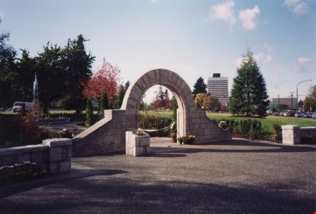
Opening of Lohn Gardens and Restored Jubilee Grove Arch
https://search.heritageburnaby.ca/link/archivedescription37358
- Repository
- City of Burnaby Archives
- Date
- 1994
- Collection/Fonds
- Burnaby Historical Society fonds
- Description Level
- Item
- Physical Description
- 1 photograph : col. ; 10 x 15 cm
- Scope and Content
- Photograph of the Earl and Jennie Lohn Perennial Garden and the restored Jubilee Grove Arch - taken during the opening of the gardens in 1994 after the restoration work was completed. This Central Park landmark was built in 1939 as part of "Jubilee Grove", a garden established in 1935 to commemora…
- Repository
- City of Burnaby Archives
- Date
- 1994
- Collection/Fonds
- Burnaby Historical Society fonds
- Subseries
- Photographs subseries
- Physical Description
- 1 photograph : col. ; 10 x 15 cm
- Description Level
- Item
- Record No.
- 360-001
- Access Restriction
- No restrictions
- Reproduction Restriction
- Reproduce for fair dealing purposes only
- Accession Number
- BHS2007-04
- Scope and Content
- Photograph of the Earl and Jennie Lohn Perennial Garden and the restored Jubilee Grove Arch - taken during the opening of the gardens in 1994 after the restoration work was completed. This Central Park landmark was built in 1939 as part of "Jubilee Grove", a garden established in 1935 to commemorate the Jubilee of King George V and dedicated during Burnaby's May Day Celebration.
- Media Type
- Photograph
- Notes
- Title based on contents of photograph
- Geographic Access
- Kingsway
- Patterson Avenue
- Historic Neighbourhood
- Central Park (Historic Neighbourhood)
- Planning Study Area
- Garden Village Area
Images