Central Park Entrance Gate
- Repository
- Burnaby Heritage Planning
- Description
- The Central Park Entrance Gate is the ceremonial entrance to Burnaby’s historic Central Park from Kingsway, and consists of two massive stone pillars, approximately 7.5 metres high and 1.8 metres square, adjacent gate posts and a low flanking stone wall that curves into the park to the east.
- Associated Dates
- 1913
- Formal Recognition
- Heritage Designation, Community Heritage Register
- Street View URL
- Google Maps Street View
- Repository
- Burnaby Heritage Planning
- Geographic Access
- Imperial Street
- Associated Dates
- 1913
- Formal Recognition
- Heritage Designation, Community Heritage Register
- Enactment Type
- Bylaw No. 9807
- Enactment Date
- 23/11/1992
- Description
- The Central Park Entrance Gate is the ceremonial entrance to Burnaby’s historic Central Park from Kingsway, and consists of two massive stone pillars, approximately 7.5 metres high and 1.8 metres square, adjacent gate posts and a low flanking stone wall that curves into the park to the east.
- Heritage Value
- The Central Park Entrance Gate is significant as a ceremonial entry to a major park, for its connection with the early history of the British Columbia Electric Railway (BCER) and as an important design by an accomplished British Columbian architect.
When the original interurban line between Vancouver and New Westminster was constructed in 1891, one of the first stations was located where the tramway crossed the Vancouver-Westminster Road (now Kingsway) within the newly-created Central Park. The interurban line ran through the park on a diagonal right-of-way (the current SkyTrain line, opened in 1986, follows this original alignment). In 1912 an agreement was reached between the successor interurban company, the BCER, and the Central Park Provincial Park Board, to deed additional land for an expanded right-of-way through the Park in exchange for improvements that included the construction of an ornamental stone wall and gate with an iron arch, with an illuminated 'Central Park' sign, adjacent to the interurban station on Kingsway. This was an early and rare example of an electric sign used for a public recreation facility.
The Gate is also significant as a surviving early design by Robert Lyon (1879-1963), an Edinburgh-born and trained immigrant who was one of the most accomplished of British Columbia's early architects. After he moved to Vancouver, he was employed by the BCER from 1911 until 1918, and worked on a broad range of projects including some of the grandest and most innovative local industrial structures of the time. The arch was built by the Westminster Ironworks Company, one of the leading firms of its kind in Western Canada, operated by John Reid of New Westminster. The Gate was completed in 1914; in 1968 the decorative ironwork was removed due to corrosion and placed in storage.
- Defining Elements
- Key elements that define the heritage character of the Central Park Entrance Gate include its:
- two subtly tapered massive stone pillars, which rise in stages from a larger base to a shaft with random coursed multi-coloured granite with roughly formed grey granite quoins, to a top formed of finely finished grey granite blocks with a coved and bracketed cap
- adjacent gate posts with monolithic pyramidal granite caps
- low flanking stone wall that curves into the park to the east, constructed of random coursed multi-coloured granite with a river rock triangular cap
- Historic Neighbourhood
- Central Park (Historic Neighbourhood)
- Planning Study Area
- Maywood Area
- Organization
- British Columbia Electric Railway
- Central Park Provincial Park Board
- Architect
- Robert Lyon
- Builder
- John Reid
- Westminster Iron Works Co.
- Function
- Primary Current--Park Fixture
- Primary Historic--Park Fixture
- Community
- Burnaby
- Cadastral Identifier
- P.I.D. No. 017-767-172
Legal Description: Block B of Lot 2 Except Firstly: Part on Plan 8669 and Secondly: Part on Plan LMP4689 District Lot 151, Group 1, New Westminster District, Plan 3443
- Boundaries
- The property (Central Park) is a municipally-owned park that lies at the western edge of Burnaby, between 49th Avenue to the south, Kingsway to the north, Boundary Road to the west and Patterson Avenue to the east.
- Area
- 853,403.82
- Contributing Resource
- Structure
- Landscape Feature
- Ownership
- Public (local)
- Names
- Lyon, Robert
- Reid, John
- Westminster Iron Works Company
- British Columbia Electric Railway Company
- Central Park Provincial Park Board
- Subjects
- Structures - Fences
- Street Address
- 3883 Imperial Street
- Street View URL
- Google Maps Street View
Less detail
H.T. Ceperley Estate 'Fairacres' Estate Gate
- Repository
- Burnaby Heritage Planning
- Description
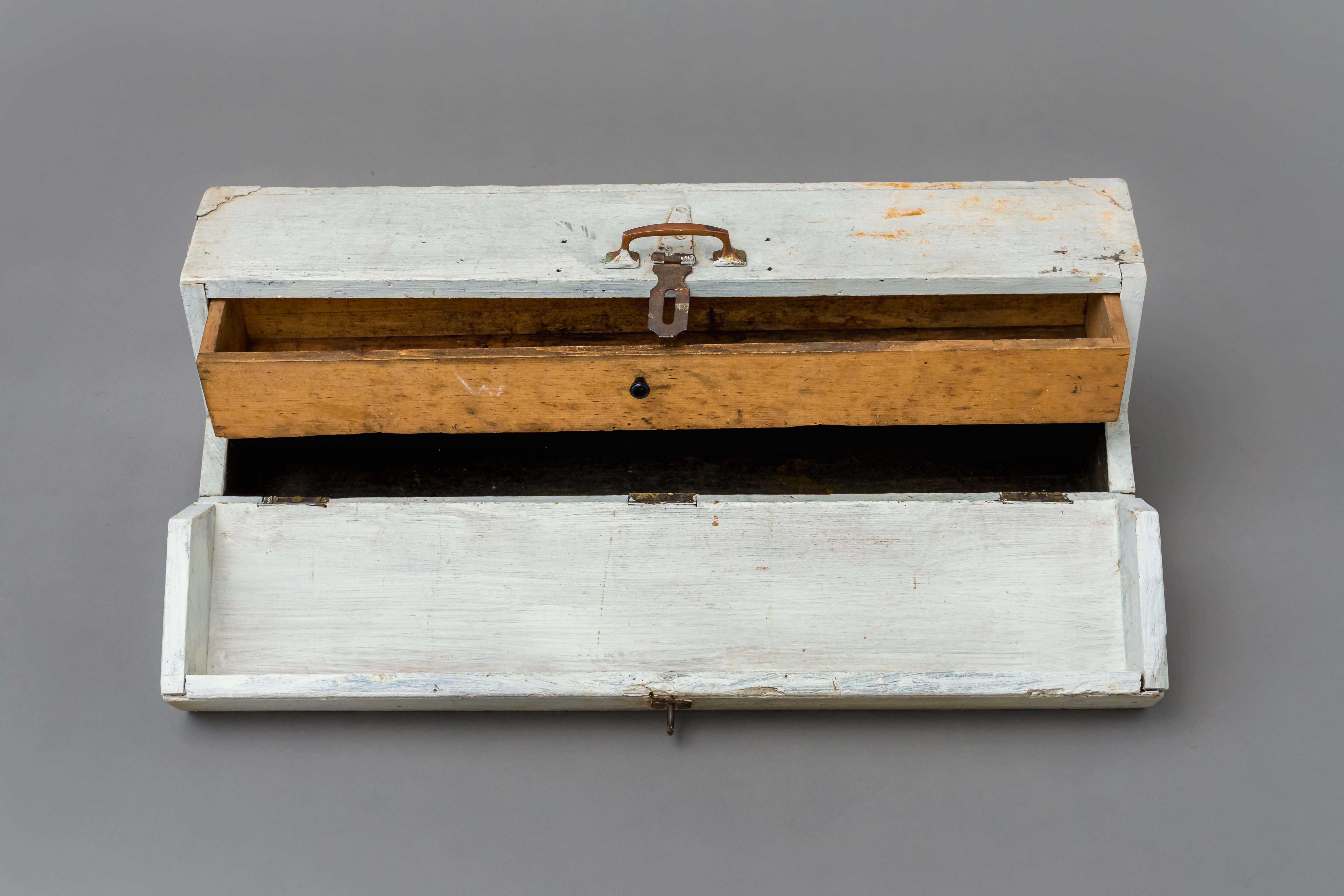
- The 'Fairacres Estate Gate' marks the location of one of the original driveway entrances to the estate.
- Associated Dates
- 1911
- Formal Recognition
- Heritage Designation, Community Heritage Register
- Street View URL
- Google Maps Street View
- Repository
- Burnaby Heritage Planning
- Geographic Access
- Deer Lake Avenue
- Associated Dates
- 1911
- Formal Recognition
- Heritage Designation, Community Heritage Register
- Enactment Type
- Bylaw No. 140665
- Enactment Date
- 23/11/1992
- Description
- The 'Fairacres Estate Gate' marks the location of one of the original driveway entrances to the estate.
- Heritage Value
- Fairacres was designed as a country estate with a working farm that included over 10 acres of productive berry and vegetable fields, with a large kitchen garden, a root house to store food, and greenhouses heated by steam. The agricultural potential ofthe Deer Lake area made it one of the first parts of the municipality to attract settlement.
Construction of the Fairacres Estate represented a shift toward wealthy country estates over more modest farms, and the Ceperleys employed a large staff to manage the estate's agricultural production. Agricultural use of the estate continued when a Catholic order of Benedictine monks purchased the estate as part of the Priory of St. Joseph and the Seminary of Christ the King, and continued to farm the land until 1953.
The overall architectural intention of the estate's architect was to reflect the ideals of the Arts & Crafts movement to showcase craftsmanship, and to incorporate high quality materials, including many local materials, such as wood and stone from the site. On the mansion exterior, the rustic style is seen in the use of natural materials such as cedar shingles and siding, cobblestone foundations and chimneys and the half-timbering in gable ends. The estate's remaining gate pillar features the same rustic field and cobblestones used on the mansion.
The original estate driveway had two entrances constructed in 1910, each marked by a pair of entry gate pillars which supported iron gates. The main entrance gate pillars which marked the lower driveway and the east pillar of the upper entrance were demolished many years ago and the iron gates removed. A single gate pillar remains marking the upper driveway, adjacent to the Garage and Stables. This gate pillar is a significant site feature and incorporates cobble stone and a carved sandstone capstone.
- Defining Elements
- Key elements that define the heritage character of the ‘Fairacres Estate Gate' include:
- setting in relation to the estate boundary and estate buildings
- Cobble stone and sandstone construction, which represents a typical Arts and Crafts use of local materials, and matches the extensive use of cobblestone as chimneys and foundations on the Fairacres mansion, as well as the use of sandstone on the mansion's exterior.
- Locality
- Deer Lake Park
- Historic Neighbourhood
- Burnaby Lake (Historic Neighbourhood)
- Planning Study Area
- Douglas-Gilpin Area
- Function
- Primary Historic--Estate
- Community
- Burnaby
- Cadastral Identifier
- P.I.D. No. 004-493-311
Legal Description: Block 3 Except: Part subdivided by Plan 26865, District Lot 79, Group 1, New Westminster District, Plan 536
- Boundaries
- ‘Fairacres’ is comprised of a single municipally-owned property located at 6344 Deer Lake Avenue, Burnaby.
- Area
- 17,065.00
- Contributing Resource
- Landscape Feature
- Ownership
- Public (local)
- Other Collection
- Burnaby Historical Society, Community Archives: Ceperley Photograph Album
- Documentation
- Heritage Site Files: PC77000 20. City of Burnaby Planning and Building Department, 4949 Canada Way, Burnaby, B.C., V5G 1M2
- Names
- Ceperley, H.T.
- Ceperley, Grace
- Subjects
- Structures - Fences
- Street Address
- 6344 Deer Lake Avenue
- Street View URL
- Google Maps Street View
Less detail
Cutting pile tops for Nicomen Slough Bridge
- Repository
- City of Burnaby Archives
- Date
- 1927
- Collection/Fonds
- Burnaby Historical Society fonds
- Description Level
- Item
- Physical Description
- 1 photograph : b&w ; 6.8 x 12.2 cm on page 17.5 x 23.7 cm
- Scope and Content
- Photograph of workmen operating machinery to cut pile tops for the Nicomen Slough Bridge, near Deroche.
Nicomen Slough Bridge
- Repository
- City of Burnaby Archives
- Date
- 1927
- Collection/Fonds
- Burnaby Historical Society fonds
- Description Level
- Item
- Physical Description
- 1 photograph : sepia ; 7.7 x 12.6 cm on page 17.4 x 22.5 cm
- Scope and Content
- Photograph of workmen and equipment being used in the construction of Nicomen bridge.
Nicomen Slough Bridge construction
- Repository
- City of Burnaby Archives
- Date
- 1927
- Collection/Fonds
- Burnaby Historical Society fonds
- Description Level
- Item
- Physical Description
- 1 photograph : b&w ; 6.9 x 12 cm on page 17.5 x 23.7 cm
- Scope and Content
- Photograph of workmen operating machinery to cut pile tops for the Nicomen Slough Bridge, near Deroche.
Nicomen Slough Bridge construction
- Repository
- City of Burnaby Archives
- Date
- 1927
- Collection/Fonds
- Burnaby Historical Society fonds
- Description Level
- Item
- Physical Description
- 1 photograph : sepia ; 7.7 x 12.8 cm on page 17.4 x 22.5 cm
- Scope and Content
- Photograph of workmen and equipment being used in the construction of Nicomen bridge.
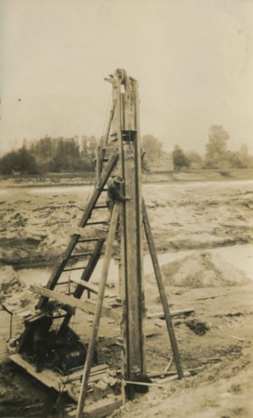
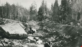
Irrigation flume
- Repository
- Burnaby Village Museum
- Date
- [1919]
- Collection/Fonds
- Burnaby Village Museum Photograph collection
- Description Level
- Item
- Physical Description
- 1 photograph : sepia ; 16 x 11 cm, mounted on card ; 23 x 17.5 cm
- Scope and Content
- Photograph of an irrigation flume (or logging flume) believed to be built by Tom Irvine in the interior plateau of British Columbia. The flume is in the middle of construction as the pile driver is visible in the distance pounding in its verticals. As well, the flume's walkway has been started.
- Repository
- Burnaby Village Museum
- Collection/Fonds
- Burnaby Village Museum Photograph collection
- Description Level
- Item
- Physical Description
- 1 photograph : sepia ; 16 x 11 cm, mounted on card ; 23 x 17.5 cm
- Scope and Content
- Photograph of an irrigation flume (or logging flume) believed to be built by Tom Irvine in the interior plateau of British Columbia. The flume is in the middle of construction as the pile driver is visible in the distance pounding in its verticals. As well, the flume's walkway has been started.
- Subjects
- Construction Tools and Equipment
- Geographic Features - Rivers
- Structures - Flumes
- Accession Code
- HV975.33.3ba
- Access Restriction
- No restrictions
- Date
- [1919]
- Media Type
- Photograph
- Scan Resolution
- 600
- Scan Date
- 2/2/2010
- Scale
- 100
- Notes
- Title based on contents of photograph
- Image from personal photograph album of Tom "Tommy" Irvine (HV975.33.3)
Less detail
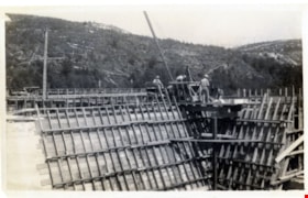
New Brunette Dam construction
- Repository
- City of Burnaby Archives
- Date
- [1931] (date of original), copied 1986
- Collection/Fonds
- Burnaby Historical Society fonds
- Description Level
- Item
- Physical Description
- 1 photograph : b&w ; 12.7 x 17.8 cm print
- Scope and Content
- Photograph of the construction of new Brunette River dam.
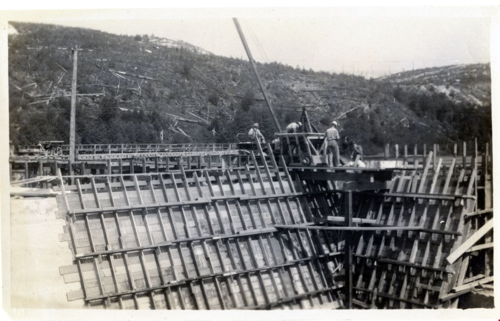
New Brunette Dam construction
- Repository
- City of Burnaby Archives
- Date
- 1931 (date of original), copied 1986
- Collection/Fonds
- Burnaby Historical Society fonds
- Description Level
- Item
- Physical Description
- 1 photograph : b&w ; 12.7 x 17.8 cm print
- Scope and Content
- Photograph of the construction of new Brunette River dam.
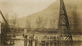
Old and new bridges
- Repository
- City of Burnaby Archives
- Date
- 1926
- Collection/Fonds
- Burnaby Historical Society fonds
- Description Level
- Item
- Physical Description
- 1 photograph : b&w ; 6.5 x 11.4 cm on page 17.5 x 26.5 cm
- Scope and Content
- Photograph of two bridges, identified as the old and the new, over Kanaka Creek. A a drag line rig can be seen at the far end of the bridge in the foreground. This photograph appears to have been taken by Arthur Peers, who travelled through the Fraser River Valley and worked on the construction of…
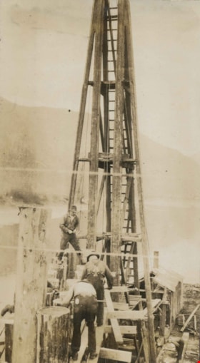
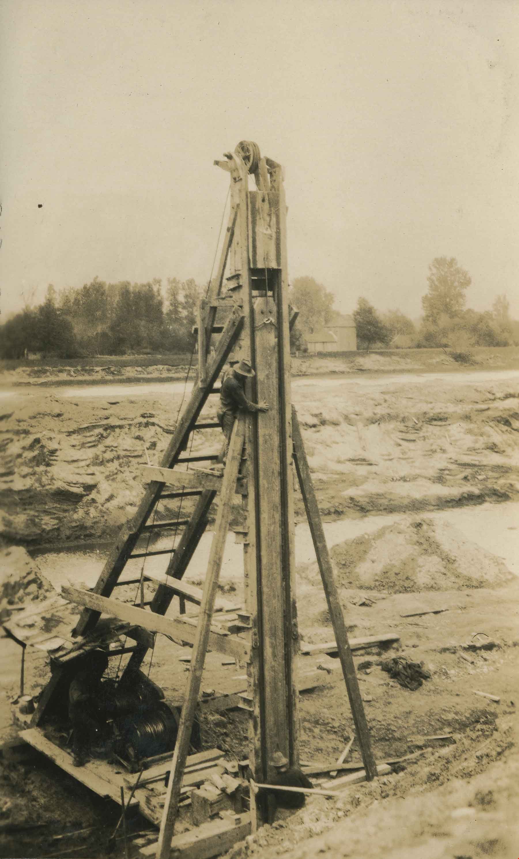
Pile driver at work
- Repository
- Burnaby Village Museum
- Date
- [1919]
- Collection/Fonds
- Burnaby Village Museum Photograph collection
- Description Level
- Item
- Physical Description
- 1 photograph : sepia ; 10 x 6 cm
- Scope and Content
- Photograph of structure believed to be built by Tom Irvine in the interior plateau of British Columbia. The structure is in the middle of construction as the pile driver is visible in the foreground pounding in its verticals.
- Repository
- Burnaby Village Museum
- Collection/Fonds
- Burnaby Village Museum Photograph collection
- Description Level
- Item
- Physical Description
- 1 photograph : sepia ; 10 x 6 cm
- Scope and Content
- Photograph of structure believed to be built by Tom Irvine in the interior plateau of British Columbia. The structure is in the middle of construction as the pile driver is visible in the foreground pounding in its verticals.
- Subjects
- Construction Tools and Equipment
- Structures - Flumes
- Accession Code
- HV975.33.3be
- Access Restriction
- No restrictions
- Date
- [1919]
- Media Type
- Photograph
- Scan Resolution
- 600
- Scan Date
- 2/2/2010
- Scale
- 100
- Notes
- Title based on contents of photograph
- Image from personal photograph album of Tom "Tommy" Irvine (HV975.33.3)
Less detail
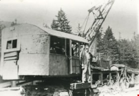
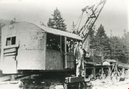
Pile drivers
- Repository
- Burnaby Village Museum
- Date
- [1919]
- Collection/Fonds
- Burnaby Village Museum Photograph collection
- Description Level
- Item
- Physical Description
- 1 photograph : b&w ; 13 x 8 cm
- Scope and Content
- Photograph of two pile drivers building a pier at an unidentified location. Three labourers are visible working with the pile drivers.
Power Dam at Powell River
- Repository
- Burnaby Village Museum
- Date
- 1924
- Collection/Fonds
- Burnaby Village Museum Photograph collection
- Description Level
- Item
- Physical Description
- 1 photograph : b&w ; 8 x 13 cm
- Scope and Content
- Photograph of the Power Dam at Powell River under construction. Labourers are visible working with a pile driver and tractor pulley at the top of the dam.
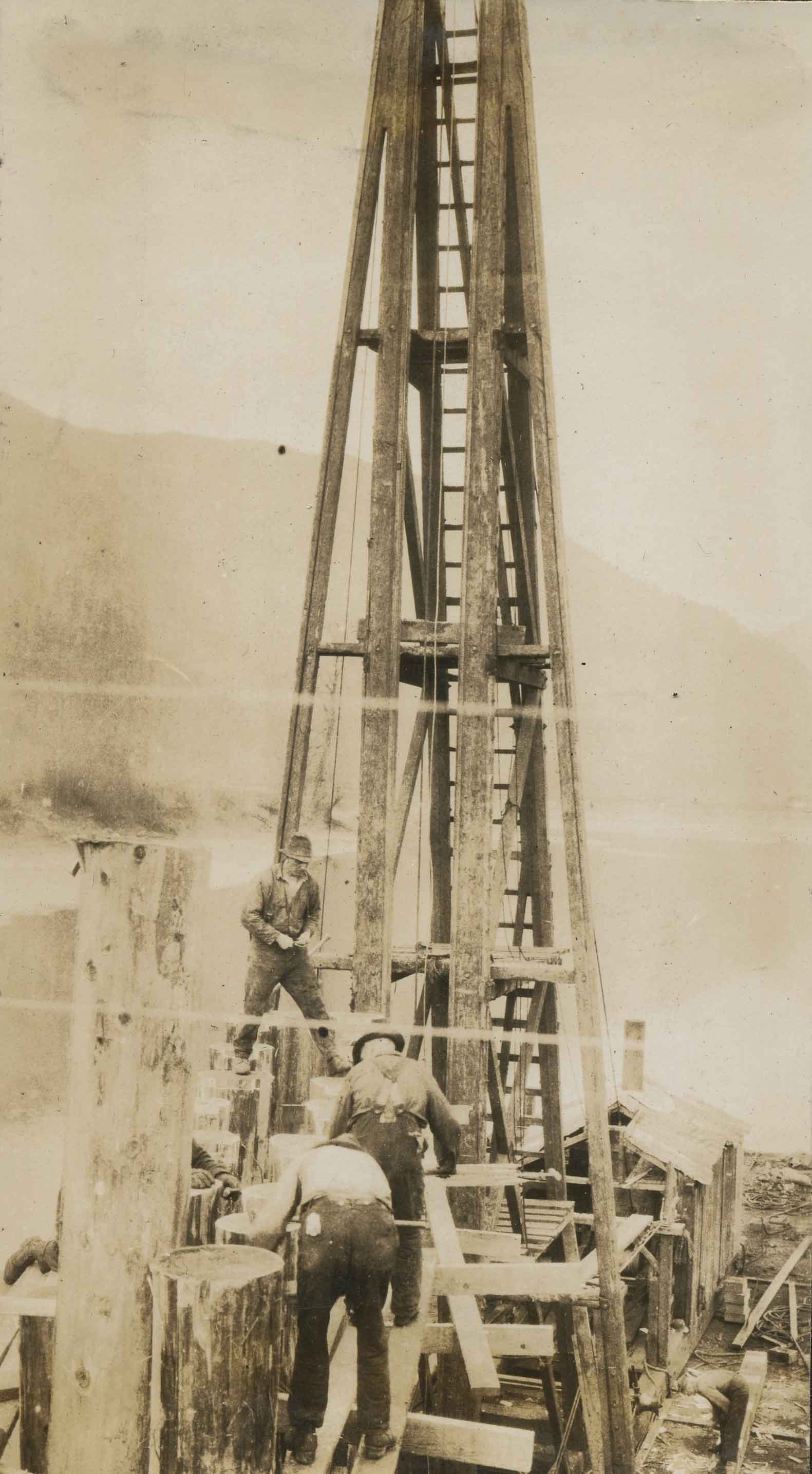
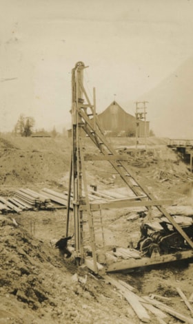
Stone-built pier
- Repository
- Burnaby Village Museum
- Date
- [1919]
- Collection/Fonds
- Burnaby Village Museum Photograph collection
- Description Level
- Item
- Physical Description
- 1 photograph : sepia ; 13.5 x 8 cm
- Scope and Content
- Photograph of a stone-built pier with a pile driver and a temporary scaffold in place to aid in the construction of (what looks to be) a road deck.
West Fill, Kanaka Creek
- Repository
- City of Burnaby Archives
- Date
- [1926]
- Collection/Fonds
- Burnaby Historical Society fonds
- Description Level
- Item
- Physical Description
- 1 photograph : b&w ; 5.4 x 11.2 cm on page 17.5 x 26.5 cm
- Scope and Content
- Photograph of a drag line rig working near a bridge at a location identified as Kanaka Creek. This photograph appears to have been taken by Arthur Peers, who travelled through the Fraser River Valley and worked on the construction of the Trans-Provincial Highway during the later 1920s.
Bert Porter on a steamroller
- Repository
- City of Burnaby Archives
- Date
- [1919] (date of original), copied 1985
- Collection/Fonds
- Burnaby Historical Society fonds
- Description Level
- Item
- Physical Description
- 1 photograph : b&w ; 8.8 x 12.5 cm print
- Scope and Content
- Photograph of Bert Porter with a municipal steamroller on Douglas Road. He worked many years operating a steam roller for the municipality, flattening out gravel streets after grading, and was the husband of Lillie Lewis Porter.
Bill Speirs
- Repository
- City of Burnaby Archives
- Date
- 1929 (date of original), copied 1986
- Collection/Fonds
- Burnaby Historical Society fonds
- Description Level
- Item
- Physical Description
- 1 photograph : b&w ; 12.7 x 17.8 cm print
- Scope and Content
- Photograph of Bill Speirs operating a steam shovel for the municipality of Burnaby. Here he is working on the roads around Gilley Avenue and Imperial Street (formerly Windsor Street).


![Irrigation flume, [1919] thumbnail](/media/hpo/_Data/_BVM_Images/1974/197500330003ba.jpg?width=280)
![Irrigation flume, [1919] thumbnail](/media/hpo/_Data/_BVM_Images/1974/197500330003ba.jpg)
![New Brunette Dam construction, [1931] (date of original), copied 1986 thumbnail](/media/hpo/_Data/_Archives_Images/_Unrestricted/204/204-321.jpg?width=280)
![New Brunette Dam construction, [1931] (date of original), copied 1986 thumbnail](/media/hpo/_Data/_Archives_Images/_Unrestricted/204/204-321.jpg)


![Pile driver, [1919] thumbnail](/media/hpo/_Data/_BVM_Images/1974/197500330003l.jpg?width=280)
![Pile driver, [1919] thumbnail](/media/hpo/_Data/_BVM_Images/1974/197500330003l.jpg)
![Pile driver at work, [1919] thumbnail](/media/hpo/_Data/_BVM_Images/1974/197500330003be.jpg?width=280)
![Pile driver at work, [1919] thumbnail](/media/hpo/_Data/_BVM_Images/1974/197500330003be.jpg)
![Pile drivers, [1919] thumbnail](/media/hpo/_Data/_BVM_Images/1974/197500330003j.jpg?width=280)
![Pile drivers, [1919] thumbnail](/media/hpo/_Data/_BVM_Images/1974/197500330003j.jpg)
![Pile drivers, [1919] thumbnail](/media/hpo/_Data/_BVM_Images/1974/197500330003t.jpg?width=280)
![Pile drivers, [1919] thumbnail](/media/hpo/_Data/_BVM_Images/1974/197500330003t.jpg)
![Stone-built pier, [1919] thumbnail](/media/hpo/_Data/_BVM_Images/1974/197500330003c.jpg?width=280)
![Stone-built pier, [1919] thumbnail](/media/hpo/_Data/_BVM_Images/1974/197500330003c.jpg)
![West Fill, Kanaka Creek, [1926] thumbnail](/media/hpo/_Data/_Archives_Images/_Unrestricted/001/020-081.jpg?width=280)
![West Fill, Kanaka Creek, [1926] thumbnail](/media/hpo/_Data/_Archives_Images/_Unrestricted/001/020-081.jpg)
![Bert Porter on a steamroller, [1919] (date of original), copied 1985 thumbnail](/media/hpo/_Data/_Archives_Images/_Unrestricted/126/140-011.jpg?width=280)
![Bert Porter on a steamroller, [1919] (date of original), copied 1985 thumbnail](/media/hpo/_Data/_Archives_Images/_Unrestricted/126/140-011.jpg)