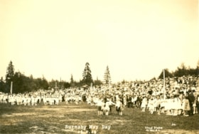
Burnaby May Day
- Repository
- Burnaby Village Museum
- Date
- May 26, 1928
- Collection/Fonds
- Burnaby Village Museum Photograph collection
- Description Level
- Item
- Physical Description
- 1 photograph : sepia ; 11 x 16.5 cm
- Scope and Content
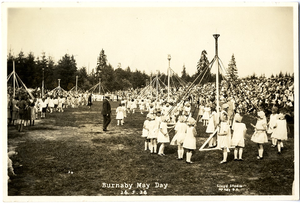
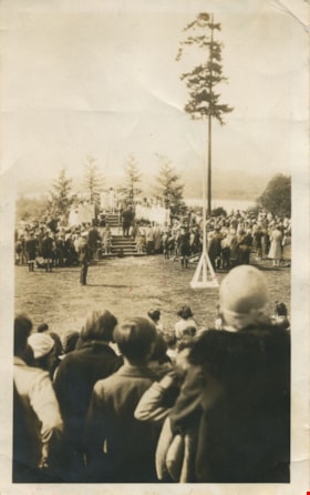
- Photograph of folk dancing groups celebrating Burnaby's May Day at Robert Burnaby Park. The dance groups are composed of young boys and girls. Some dance groups are gathered around Maypoles, and a crowd is on a hill by the field watching.
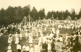
Burnaby May Day
- Repository
- Burnaby Village Museum
- Date
- May 26, 1928
- Collection/Fonds
- Burnaby Village Museum Photograph collection
- Description Level
- Item
- Physical Description
- 1 photograph : sepia ; 11 x 16.5 cm
- Scope and Content
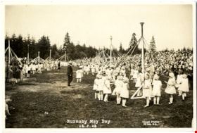
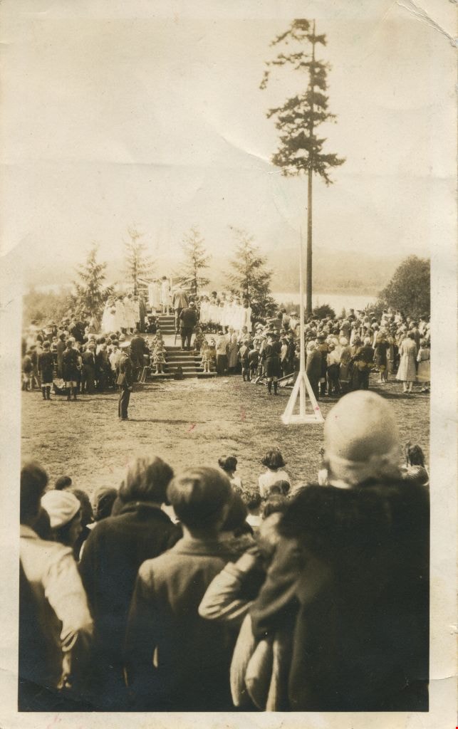
- Photograph of several maypoles that have been errected in celebration of Burnaby's May Day at Robert Burnaby Park. At every maypole, there are children (mainly girls), each holding a ribbon. The girls are wearing white dresses and some have white caps. A crowd is watching.
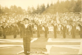
Salute to the Flag
- Repository
- Burnaby Village Museum
- Date
- May 26, 1928
- Collection/Fonds
- Burnaby Village Museum Photograph collection
- Description Level
- Item
- Physical Description
- 1 photograph : sepia ; 11 x 16.5 cm
- Scope and Content
- Photograph of a group of young men in sailor uniforms saluting the flag at Burnaby May Day at Robert Burnaby Park. There is a large Union Jack laid out on the ground, and the sailors are standing around its edges of the flag. A crowd is gathered behind them.
Burnaby May Day
- Repository
- Burnaby Village Museum
- Date
- May 26, 1928
- Collection/Fonds
- Burnaby Village Museum Photograph collection
- Description Level
- Item
- Physical Description
- 1 photograph : sepia ; 11 x 16.5 cm
- Scope and Content
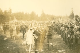
- Photograph of the procession to the retiring Queen at Burnaby May Day, at Robert Burnaby Park. The retiring May Queen is escorted by a gentleman in suit holding his hat. There are boys in uniforms lined up along both sides of the procession, with a large crowd gathered behind them.
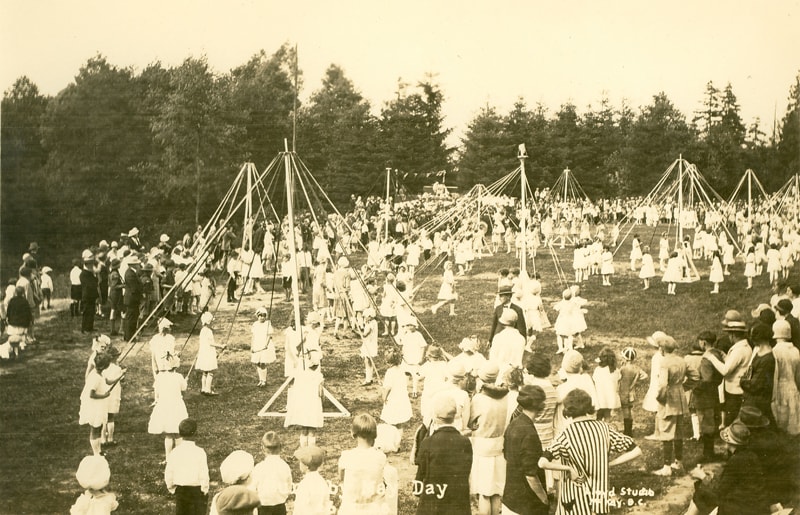
Burnaby May Day
- Repository
- Burnaby Village Museum
- Date
- May 26, 1928
- Collection/Fonds
- Burnaby Girl Guides fonds
- Description Level
- Item
- Physical Description
- 1 photograph : sepia ;11.5 x 17 cm
- Scope and Content
- Photograph of Burnaby May Day held in Robert Burnaby Park. Children are wearing white dresses and gathered around several may poles set up on a large field during the Burnaby May Day celebrations. The May pole on the left side of the photograph is surrounded by young girls in Girl Guide uniforms. A…
- Repository
- Burnaby Village Museum
- Collection/Fonds
- Burnaby Girl Guides fonds
- Series
- Burnaby Girl Guides scrapbooks and photographs series
- Description Level
- Item
- Physical Description
- 1 photograph : sepia ;11.5 x 17 cm
- Scope and Content
- Photograph of Burnaby May Day held in Robert Burnaby Park. Children are wearing white dresses and gathered around several may poles set up on a large field during the Burnaby May Day celebrations. The May pole on the left side of the photograph is surrounded by young girls in Girl Guide uniforms. A large crowd is gathered and is looking on.
- Subjects
- Events - May Day
- Names
- Girl Guides of Canada
- Geographic Access
- Robert Burnaby Park
- Accession Code
- BV015.35.240
- Access Restriction
- No restrictions
- Reproduction Restriction
- No known restrictions
- Date
- May 26, 1928
- Media Type
- Photograph
- Historic Neighbourhood
- Burnaby Lake (Historic Neighbourhood)
- Planning Study Area
- Lakeview-Mayfield Area
- Scan Resolution
- 600
- Scan Date
- January 4, 2021
- Scale
- 100
- Photographer
- Lloyd, Frank Ernest
- Notes
- Title based on content of photograph
- Type script in white on bottom of photograph reads: "Burnaby May Day / 26. 5.28 / Lloyd Studio / McKay B.C."
- Stamp in black ink on verso of photograph reads: "Lloyd's Studio / 3966 Kingsway / McKay, B.C. Calr. 343R2"
- Photograph is a part of scrapbook (page 25) "Burnaby Girl Guides. -- [1914]-1969, predominant ca. 1920" (BV.015.35.164)
Less detail
Burnaby May Day ceremony
- Repository
- Burnaby Village Museum
- Date
- May 26, 1928
- Collection/Fonds
- Burnaby Girl Guides fonds
- Description Level
- Item
- Physical Description
- 1 photograph : sepia ;11.5 x 17 cm
- Scope and Content
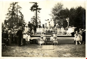
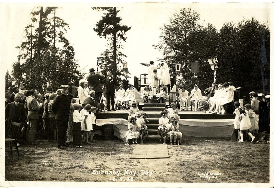
- Photograph of the crowning of May Queen Sylvia Murley (later Sylvia Auvache) at Robert Burnaby Park. The May Queen and her suite are seated on chairs on a stage, with flower girls seated on the steps leading up to the stage. Men, women and children are gathered around the stage to watch the crownin…
- Repository
- Burnaby Village Museum
- Collection/Fonds
- Burnaby Girl Guides fonds
- Series
- Burnaby Girl Guides scrapbooks and photographs series
- Description Level
- Item
- Physical Description
- 1 photograph : sepia ;11.5 x 17 cm
- Scope and Content
- Photograph of the crowning of May Queen Sylvia Murley (later Sylvia Auvache) at Robert Burnaby Park. The May Queen and her suite are seated on chairs on a stage, with flower girls seated on the steps leading up to the stage. Men, women and children are gathered around the stage to watch the crowning of the May Queen.
- Subjects
- Events - May Day
- Names
- Murley, Sylvia
- Auvache, Sylvia Murley
- Girl Guides of Canada
- Geographic Access
- Robert Burnaby Park
- Accession Code
- BV015.35.241
- Access Restriction
- No restrictions
- Reproduction Restriction
- No known restrictions
- Date
- May 26, 1928
- Media Type
- Photograph
- Historic Neighbourhood
- Burnaby Lake (Historic Neighbourhood)
- Planning Study Area
- Lakeview-Mayfield Area
- Related Material
- See also photograph HV972.204.4
- Scan Resolution
- 600
- Scan Date
- January 4, 2021
- Scale
- 100
- Notes
- Title based on content of photograph
- Type script in white on bottom of photograph reads: "Burnaby May Day / 26. 5.28 / Lloyd Studio / McKay B.C."
- Stamp in black ink on verso of photograph reads: "Lloyd's Studio / 3966 Kingsway / McKay, B.C. Calr. 343R2"
- Photograph is a part of scrapbook (page 26) "Burnaby Girl Guides. -- [1914]-1969, predominant ca. 1920" (BV.015.35.164)
Less detail
Land being cleared for Saint Theresa's Roman Catholic Church
- Repository
- Burnaby Village Museum
- Date
- 1929
- Collection/Fonds
- Burnaby Village Museum Photograph collection
- Description Level
- Item
- Physical Description
- 1 photograph : b&w ; 6.7 x 11.4 cm
- Scope and Content
- Photograph of three unidentified men standing on Douglas Road (later renamed in part Canada Way) with Laurel Street in the background on the left and the site of Saint Theresa's Roman Catholic Church as a lot with blackened stumps. The church was located at the southeast corner of Canada Way and L…
- Repository
- Burnaby Village Museum
- Collection/Fonds
- Burnaby Village Museum Photograph collection
- Description Level
- Item
- Physical Description
- 1 photograph : b&w ; 6.7 x 11.4 cm
- Scope and Content
- Photograph of three unidentified men standing on Douglas Road (later renamed in part Canada Way) with Laurel Street in the background on the left and the site of Saint Theresa's Roman Catholic Church as a lot with blackened stumps. The church was located at the southeast corner of Canada Way and Laurel Street. According to an accompanying note located with the photograph, the first church building burned to the ground the night before it was to be blessed. Insurance for the church had been arranged for by Colonel Dorrell only hours before it was burned and even though signatures had not been affixed to the policy, the insurance company honoured the claim. The second building was smaller and had no basement. Father Trainer was the first priest. This church was torn down in 1974 and a new church building was erected across the road on Canada Way.
- Subjects
- Land Clearing
- Names
- St. Theresa's Roman Catholic Church
- Geographic Access
- Douglas Road
- Canada Way
- Laurel Street
- Accession Code
- HV975.105.1
- Access Restriction
- No restrictions
- Reproduction Restriction
- No known restrictions
- Date
- 1929
- Media Type
- Photograph
- Historic Neighbourhood
- Burnaby Lake (Historic Neighbourhood)
- Planning Study Area
- Douglas-Gilpin Area
- Scan Resolution
- 600
- Scan Date
- 2023-06-06
- Notes
- Title based on contents of photograph
- Information on the scope and content of the photograph is taken from an acquisition record from the time of the accession
Less detail
Construction of Saint Theresa's Roman Catholic Church
- Repository
- Burnaby Village Museum
- Date
- March 19, 1929
- Collection/Fonds
- Burnaby Village Museum Photograph collection
- Description Level
- Item
- Physical Description
- 1 photograph : sepia ; 6.9 x 11.5 cm
- Scope and Content
- Photograph of Douglas Road (later renamed in part Canada Way) with Laurel Street in the background on the left and the site of Saint Theresa's Roman Catholic Church as a lot with blackened stumps. The church was located at the southeast corner of Canada Way and Laurel Street. The photograph is ta…
- Repository
- Burnaby Village Museum
- Collection/Fonds
- Burnaby Village Museum Photograph collection
- Description Level
- Item
- Physical Description
- 1 photograph : sepia ; 6.9 x 11.5 cm
- Scope and Content
- Photograph of Douglas Road (later renamed in part Canada Way) with Laurel Street in the background on the left and the site of Saint Theresa's Roman Catholic Church as a lot with blackened stumps. The church was located at the southeast corner of Canada Way and Laurel Street. The photograph is taken from the same angle as HV975.105.1. There is a freight wagon loaded with lumber, pulled by two horses on Douglas Road. An annotation on the back of the photo reads, "March 19th 1929 / The first load of lumber taken for the construction of St St [sic] Therese [sic] Church on the Grandview Highway / Burnaby BC."
- Subjects
- Construction
- Transportation - Horses
- Transportation - Wagons
- Names
- St. Theresa's Roman Catholic Church
- Geographic Access
- Douglas Road
- Canada Way
- Laurel Street
- Accession Code
- HV975.105.2
- Access Restriction
- No restrictions
- Reproduction Restriction
- No known restrictions
- Date
- March 19, 1929
- Media Type
- Photograph
- Historic Neighbourhood
- Burnaby Lake (Historic Neighbourhood)
- Planning Study Area
- Douglas-Gilpin Area
- Scan Resolution
- 600
- Scan Date
- 2023-06-13
- Notes
- Title based on contents of photograph
- Information on the scope and content of the photograph is taken from an acquisition record from the time of the accession
Less detail
Eight Clergymen at Saint Theresa's Roman Catholic Church
- Repository
- Burnaby Village Museum
- Date
- [192-]
- Collection/Fonds
- Burnaby Village Museum Photograph collection
- Description Level
- Item
- Physical Description
- 1 photograph : b&w ; 5.7 x 8.2 cm
- Scope and Content
- Photograph of eight unidentified clergymen posed outside in front of a brick building. Four are standing and the other four are seated in front of the standing men. On the right side of the photo, there is a sign that reads, "In Your Prayers / Kindly Remember." The location has been identified as…
- Repository
- Burnaby Village Museum
- Collection/Fonds
- Burnaby Village Museum Photograph collection
- Description Level
- Item
- Physical Description
- 1 photograph : b&w ; 5.7 x 8.2 cm
- Scope and Content
- Photograph of eight unidentified clergymen posed outside in front of a brick building. Four are standing and the other four are seated in front of the standing men. On the right side of the photo, there is a sign that reads, "In Your Prayers / Kindly Remember." The location has been identified as Saint Theresa's Roman Catholic Church. The church was located at the southeast corner of Canada Way and Laurel Street. Built in 1929, it was torn down in 1974, and a new church, St.Theresa's Parish, was built across the street.
- Subjects
- Occupations - Clergy
- Names
- St. Theresa's Roman Catholic Church
- Geographic Access
- Douglas Road
- Canada Way
- Laurel Street
- Accession Code
- HV975.105.3
- Access Restriction
- No restrictions
- Reproduction Restriction
- May be restricted by third party rights
- Date
- [192-]
- Media Type
- Photograph
- Historic Neighbourhood
- Burnaby Lake (Historic Neighbourhood)
- Planning Study Area
- Douglas-Gilpin Area
- Scan Resolution
- 600
- Scan Date
- 2023-06-13
- Notes
- Title based on contents of photograph
Less detail
Map of proposed provincial exhibition site at Burnaby Lake
- Repository
- Burnaby Village Museum
- Date
- [between 1929 and 1931]
- Collection/Fonds
- Burnaby Village Museum Map collection
- Description Level
- Item
- Physical Description
- 1 map : photostat print ; 3 parts 45 x 33.7 cm totalling 45 x 101 cm
- Scope and Content
- Item consists of a tri-part folding map of a proposed Provincial Exhibition site located along the southern and western shore of Burnaby Lake. Exhibtion site on map identifies proposed locations for a golf course, pier, hydroplane landing ramp, sports ground, one-mile horse racing track and various…
- Repository
- Burnaby Village Museum
- Collection/Fonds
- Burnaby Village Museum Map collection
- Series
- Maps of Burnaby and Greater Vancouver series
- Description Level
- Item
- Physical Description
- 1 map : photostat print ; 3 parts 45 x 33.7 cm totalling 45 x 101 cm
- Material Details
- Scale [1:1800]
- Scope and Content
- Item consists of a tri-part folding map of a proposed Provincial Exhibition site located along the southern and western shore of Burnaby Lake. Exhibtion site on map identifies proposed locations for a golf course, pier, hydroplane landing ramp, sports ground, one-mile horse racing track and various buildings for mechanical, agricultural and botanical displays.
- Subjects
- Exhibitions
- Accession Code
- BV017.2.9
- Access Restriction
- No restrictions
- Reproduction Restriction
- No known restrictions
- Date
- [between 1929 and 1931]
- Media Type
- Cartographic Material
- Historic Neighbourhood
- Burnaby Lake (Historic Neighbourhood)
- Planning Study Area
- Burnaby Lake Area
- Scan Resolution
- 400
- Scan Date
- 2021-11-18
- Notes
- Title based on contents of map
- Scale on map reads: "150 feet to 1 inch"
- Overall measurements when fully opened: L: 98.0 cm x H: 45.3 cm ; Individual map parts: L: 32.7 cm x H: 45.0 cm
- Commercially printed label on front of portfolio card reads "PLOWRIGHT PRINTING COMPANY / TELEPHONE N.W. 1942 / 39 McKENZIE STREET NEW WESTMINSTER, B.C. / TO: [illegible writing in pencil]" in blue ink. Red typewritten text reads: "PHOTOSTAT OF BURNABY LAKE".
Less detail
McWilliams house
- Repository
- Burnaby Village Museum
- Date
- [193-]
- Collection/Fonds
- E.W. Bateman family fonds
- Description Level
- Item
- Physical Description
- 1 photograph : sepia ; 6.5 x 12 cm
- Scope and Content
- Photograph of the McWilliams house on Douglas Road. Mamie Bateman McWilliams lived here with her family and is the daughter of Edwin Wettenhall Bateman, who built Elworth (directly across the street).
McWilliams house
- Repository
- Burnaby Village Museum
- Date
- [193-]
- Collection/Fonds
- E.W. Bateman family fonds
- Description Level
- Item
- Physical Description
- 1 photograph : b&w ; 5 x 8 cm
- Scope and Content
- Photograph of the McWilliams house on Douglas Road. The house has a large patio area with a gravel road in front and a wood fence behind. A boy is sitting with a dog on the front steps. Mamie Bateman McWilliams lived here with her family, and is the daughter of Edwin Wettenhall Bateman, who built E…
McWilliams house
- Repository
- Burnaby Village Museum
- Date
- [193-]
- Collection/Fonds
- E.W. Bateman family fonds
- Description Level
- Item
- Physical Description
- 1 photograph : b&w ; 6 x 10.5 cm
- Scope and Content
- Photograph of the McWilliams house on Douglas Road. Mamie Bateman McWilliams lived here with her family and is the daughter of Edwin Wettenhall Bateman, who built Elworth (directly across the street).
Elworth
- Repository
- Burnaby Village Museum
- Date
- [1932]
- Collection/Fonds
- E.W. Bateman family fonds
- Description Level
- Item
- Physical Description
- 1 photograph : b&w ; 20.2 x 25.5 cm
- Scope and Content
- Photograph of "Elworth," the home of Edwin W. and Mary (Dale) Bateman, at 6501 Deer Lake Avenue. The house was completed in 1922 and designated a heritage property in 1992.
Elworth house
- Repository
- Burnaby Village Museum
- Date
- [1932] (date of original), copied [1974]
- Collection/Fonds
- E.W. Bateman family fonds
- Description Level
- Item
- Physical Description
- 1 photograph : b&w ; 20.5 x 25.3 cm print
- Scope and Content
- Photograph of "Elworth," the home of Edwin W. and Mary (Dale) Bateman, at 6501 Deer Lake Avenue. The house was completed in 1922 and designated a heritage property in 1992. Photograph was taken on the occasion of Warren Stafford Bateman and Winifred Dare Webster's wedding which took place on Septe…
- Repository
- Burnaby Village Museum
- Collection/Fonds
- E.W. Bateman family fonds
- Series
- Bateman family photographs series
- Description Level
- Item
- Physical Description
- 1 photograph : b&w ; 20.5 x 25.3 cm print
- Scope and Content
- Photograph of "Elworth," the home of Edwin W. and Mary (Dale) Bateman, at 6501 Deer Lake Avenue. The house was completed in 1922 and designated a heritage property in 1992. Photograph was taken on the occasion of Warren Stafford Bateman and Winifred Dare Webster's wedding which took place on September 21, 1932.
- Subjects
- Buildings - Residential - Houses
- Buildings - Heritage
- Geographic Access
- Deer Lake Avenue
- Street Address
- 6501 Deer Lake Avenue
- Accession Code
- HV974.90.9
- Access Restriction
- No restrictions
- Reproduction Restriction
- No known restrictions
- Date
- [1932] (date of original), copied [1974]
- Media Type
- Photograph
- Historic Neighbourhood
- Burnaby Lake (Historic Neighbourhood)
- Planning Study Area
- Morley-Buckingham Area
- Related Material
- For a wider shot of the same exterior view, see photograph HV974.90.8
- Scan Resolution
- 600
- Scan Date
- 2023-04-25
- Notes
- Title based on contents of photograph
- 1 b&w copy negative ; 10 x 12 cm accompanying
- Stamp on verso of photograph reads: "Better Pictures / NuGloss / Photo Finish / Vancouver Drug Co. / Limited / B61"
- Note in pencil on verso of photograph reads:"3920 Douglas Rd"
Less detail
May Day Ceremony at Robert Burnaby Park
- Repository
- Burnaby Village Museum
- Date
- May 1932
- Collection/Fonds
- Burnaby Village Museum Photograph collection
- Description Level
- Item
- Physical Description
- 1 photograph : sepia ; 12 x 7 cm
- Scope and Content
- Photograph of a May Day ceremony at Robert Burnaby Park taken from a distance. The May Queen and her suite are on the platform set up by the lake, surrounded by a large crowd (this was the first year that May Day was celebrated at Burnaby Park).
Clearing rink on Deer Lake
- Repository
- Burnaby Village Museum
- Date
- 1933
- Collection/Fonds
- Waplington family fonds
- Description Level
- Item
- Physical Description
- 1 photograph : b&w ; 7.5 x 12.3 cm
- Scope and Content
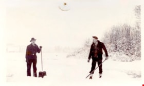
- Photograph Jack Waplington and an unidentifed man clearing snow off of Deer Lake for a skating rink.
Glen Boal and Tom Boal
- Repository
- Burnaby Village Museum
- Date
- [between 1935 and 1939]
- Collection/Fonds
- Burnaby Village Museum Photograph collection
- Description Level
- Item
- Physical Description
- 1 photograph : b&w print ; 10 x 15 cm
- Scope and Content
- Photograph of Tom and Glen Boal, sitting in an old tree in the back yard of their home on Norland Avenue. The back of the Boal house and raspberry canes are in the background. 4319 Norland Ave
- Repository
- Burnaby Village Museum
- Collection/Fonds
- Burnaby Village Museum Photograph collection
- Description Level
- Item
- Physical Description
- 1 photograph : b&w print ; 10 x 15 cm
- Material Details
- Handwritten text in ink on back reads: "Tom & Glen Boal Norland Ave. / late 1930's. They grew raspberries & / shipped them by train back East & / grew bulbs (daffodils) & sold to Forest Lawn / Glen's dad had lost an eye in the 1st WW / & had TB. Spent time in sanitorium of / TRANQUILLE" .
- Scope and Content
- Photograph of Tom and Glen Boal, sitting in an old tree in the back yard of their home on Norland Avenue. The back of the Boal house and raspberry canes are in the background. 4319 Norland Ave
- Names
- Boal, Glen
- Boal, Thomas "Tom"
- Geographic Access
- Norland Avenue
- Accession Code
- BV017.28.41
- Access Restriction
- No restrictions
- Reproduction Restriction
- No known restrictions
- Date
- [between 1935 and 1939]
- Media Type
- Photograph
- Historic Neighbourhood
- Burnaby Lake (Historic Neighbourhood)
- Planning Study Area
- Burnaby Lake Area
- Scan Resolution
- 600
- Scan Date
- 06-Mar-2018
- Notes
- Title based on contents of photograph
Less detail
Gordon Jung and Gee Shee Jung
- Repository
- Burnaby Village Museum
- Date
- [between 1935 and 1945]
- Collection/Fonds
- Julie Lee and Cecil Lee family fonds
- Description Level
- Item
- Physical Description
- 1 photograph (jpg)
- Scope and Content
- Photograph of Suey Yook "Gordon" Jung standing with his mother, Gee Shee Jung on the family farm located at 5460 Douglas Road in Burnaby (address was changed to 5286 Douglas Road in 1958).


![Eight Clergymen at Saint Theresa's Roman Catholic Church, [192-] thumbnail](/media/hpo/_Data/_BVM_Images/1975/1975_0105_0003_001.jpg?width=280)
![Eight Clergymen at Saint Theresa's Roman Catholic Church, [192-] thumbnail](/media/hpo/_Data/_BVM_Images/1975/1975_0105_0003_001.jpg)
![Map of proposed provincial exhibition site at Burnaby Lake, [between 1929 and 1931] thumbnail](/media/hpo/_Data/_BVM_Cartographic_Material/2017/2017_0002_0009_005.jpg?width=280)
![Map of proposed provincial exhibition site at Burnaby Lake, [between 1929 and 1931] thumbnail](/media/hpo/_Data/_BVM_Cartographic_Material/2017/2017_0002_0009_005.jpg)


![McWilliams house, [193-] thumbnail](/media/hpo/_Data/_BVM_Images/1990/199400220003.jpg?width=280)
![McWilliams house, [193-] thumbnail](/media/hpo/_Data/_BVM_Images/1990/199400220003.jpg)
![McWilliams house, [193-] thumbnail](/media/hpo/_Data/_BVM_Images/1990/199400220001.jpg?width=280)
![McWilliams house, [193-] thumbnail](/media/hpo/_Data/_BVM_Images/1990/199400220001.jpg)
![McWilliams house, [193-] thumbnail](/media/hpo/_Data/_BVM_Images/1990/199400220002.jpg?width=280)
![McWilliams house, [193-] thumbnail](/media/hpo/_Data/_BVM_Images/1990/199400220002.jpg)
![Elworth, [1932] thumbnail](/media/hpo/_Data/_BVM_Images/1974/197400900008.jpg?width=280)
![Elworth, [1932] thumbnail](/media/hpo/_Data/_BVM_Images/1974/197400900008.jpg)
![Elworth house, [1932] (date of original), copied [1974] thumbnail](/media/hpo/_Data/_BVM_Images/1974/197400900009.jpg?width=280)
![Elworth house, [1932] (date of original), copied [1974] thumbnail](/media/hpo/_Data/_BVM_Images/1974/197400900009.jpg)

![Glen Boal and Tom Boal, [between 1935 and 1939] thumbnail](/media/hpo/_Data/_BVM_Images/2017/201700280041_001.jpg?width=280)
![Glen Boal and Tom Boal, [between 1935 and 1939] thumbnail](/media/hpo/_Data/_BVM_Images/2017/201700280041_001.jpg)
![Glen Boal and Tom Boal, [between 1935 and 1939] thumbnail](/media/hpo/_Data/_BVM_Images/2017/201700280042_001.jpg?width=280)
![Glen Boal and Tom Boal, [between 1935 and 1939] thumbnail](/media/hpo/_Data/_BVM_Images/2017/201700280042_001.jpg)
![Gordon Jung and Gee Shee Jung, [between 1935 and 1945] thumbnail](/media/hpo/_Data/_BVM_Images/2021/2021_0019_0001_001.jpg?width=280)
![Gordon Jung and Gee Shee Jung, [between 1935 and 1945] thumbnail](/media/hpo/_Data/_BVM_Images/2021/2021_0019_0001_001.jpg)