
Loading Strawberries, BCERy, Douglas Road, Burnaby BC
https://search.heritageburnaby.ca/link/archivedescription66211
- Repository
- City of Burnaby Archives
- Date
- 1894
- Collection/Fonds
- Peers Family and Hill Family fonds
- Description Level
- Item
- Physical Description
- 1 photograph : b&w ; 13 x 18 cm on cardboard 22 x 27.5 cm
- Scope and Content
- Photograph of a group of farmers loading their crates onto a railway car. Identified (left to right), Bernard R. Hill, Louis Claude Hill, Charles Frederick Sprott, George E. Clayton, and Louis "Edgar" Sprott, who are loading up their strawberries on a street car. The farmers are lined up in a row,…
- Repository
- City of Burnaby Archives
- Date
- 1894
- Collection/Fonds
- Peers Family and Hill Family fonds
- Physical Description
- 1 photograph : b&w ; 13 x 18 cm on cardboard 22 x 27.5 cm
- Description Level
- Item
- Record No.
- 477-938
- Access Restriction
- No restrictions
- Reproduction Restriction
- No known restrictions
- Accession Number
- 2007-12
- Scope and Content
- Photograph of a group of farmers loading their crates onto a railway car. Identified (left to right), Bernard R. Hill, Louis Claude Hill, Charles Frederick Sprott, George E. Clayton, and Louis "Edgar" Sprott, who are loading up their strawberries on a street car. The farmers are lined up in a row, each sitting in their own horse and cart as they bring their strawberries to the station.
- Subjects
- Agriculture - Fruit and Berries
- Transportation - Electric Railroads
- Transportation - Horses
- Transportation - Carts
- Occupations - Farmers
- Transportation - Wagons
- Officials - Mayors and Reeves
- Names
- British Columbia Electric Railway Company
- Hill, Louis Claude "Claude"
- Hill, Bernard R.
- Every-Clayton, George
- Sprott, Louis "Edgar"
- Sprott, Charles Frederick
- Media Type
- Photograph
- Notes
- Title based on contents of photograph
- Caption on recto of photograph reads: "Loading Strawberries, B.C.E.Ry., Douglas Rd., Burnaby, B.C."
- Geographic Access
- Douglas Road
- Historic Neighbourhood
- Burnaby Lake (Historic Neighbourhood)
Images

Bancroft family subseries
https://search.heritageburnaby.ca/link/archivedescription63795
- Repository
- City of Burnaby Archives
- Date
- [1900]-1979
- Collection/Fonds
- Burnaby Historical Society fonds
- Description Level
- Subseries
- Physical Description
- Textual records and other materials
- Scope and Content
- Subseries consists of publications, correspondence and other miscellaneous papers relating to the Bancroft family's interests and work history. Topics include gardening, raising poultry, the Liberal government and the Royal Canadian Air Force. Also included in the subseries are photographs of the…
- Repository
- City of Burnaby Archives
- Date
- [1900]-1979
- Collection/Fonds
- Burnaby Historical Society fonds
- Subseries
- Bancroft family subseries
- Physical Description
- Textual records and other materials
- Description Level
- Subseries
- Accession Number
- BHS1986-44
- BHS2004-06
- Scope and Content
- Subseries consists of publications, correspondence and other miscellaneous papers relating to the Bancroft family's interests and work history. Topics include gardening, raising poultry, the Liberal government and the Royal Canadian Air Force. Also included in the subseries are photographs of the Bancroft family and friends and ephemera pertaining to agricultural farming and the air force.
- History
- Rose Croucher was born to Ann Eliza "Annie" (b. August 1861, d. 1962) and R. Coucher in January 1895. In 1907, the Croucher family moved to British Columbia. As a student, Rose studied geometrical drawing using Blair’s Canadian Drawing Series workbooks. On on February 21, 1914, Rose married James Oakes Bancroft in Vancouver, BC. Together they had three children: James A. (b. 1916 or 1917), Rosie (date unknown), and George E. (b. August 1927). The Bancroft family were poultry farmers throughout the early 1900s, transporting their farmed eggs from Burnaby to the Hudson’s Bay Company Vancouver using the British Columbia Electric Railway system. Rose Bancroft also served as Secretary-Treasurer of the Central Park Poultry Co-op Association in the 1920s until her husband's death in 1930 at the age of 42. In the late thirties and early forties, while James A. Bancroft was stationed in Calgary with the Royal Canadian Air Force, his younger siblings lived together with their mother and grandmother at 1963 21st Avenue in Burnaby. Rosie Bancroft studied French and English history in Social Studies in 1937; her brother George studied the seasons in General Science II in 1942. Rose died in 1965 at the age of 76.
- Media Type
- Textual Record
- Photograph
- Cartographic Material
- Creator
- Bancroft, Rose
- Notes
- MSS030, PC490, PC507, and MSS110
- Title based on creator and contents of subseries
![BC Electric workshop, [190-] (date of original), copied 1977 thumbnail](/media/hpo/_Data/_BVM_Images/1977/1977_0123_0019_001.jpg?width=280)
BC Electric workshop
https://search.heritageburnaby.ca/link/museumdescription613
- Repository
- Burnaby Village Museum
- Date
- [190-] (date of original), copied 1977
- Collection/Fonds
- Burnaby Village Museum Photograph collection
- Description Level
- Item
- Physical Description
- 1 photograph : b&w ; 20.2 x 25.2 cm print
- Scope and Content
- Photograph of nine men mostly dressed in suits with ties surrounded by tools and equipment. Three older men are seated in the front and the rest are standing behind them. An accompanying note in the accession file identifies the photograph as a BC Electric workshop, with Claude Hill (son of Bernard…
- Repository
- Burnaby Village Museum
- Collection/Fonds
- Burnaby Village Museum Photograph collection
- Description Level
- Item
- Physical Description
- 1 photograph : b&w ; 20.2 x 25.2 cm print
- Scope and Content
- Photograph of nine men mostly dressed in suits with ties surrounded by tools and equipment. Three older men are seated in the front and the rest are standing behind them. An accompanying note in the accession file identifies the photograph as a BC Electric workshop, with Claude Hill (son of Bernard Hill) at top right, and Jack Lister seated in the centre.
- Accession Code
- HV977.123.19
- Access Restriction
- No restrictions
- Reproduction Restriction
- No known restrictions
- Date
- [190-] (date of original), copied 1977
- Media Type
- Photograph
- Scan Resolution
- 600
- Scan Date
- 2023-07-18
- Notes
- Title based on contents of photograph
Images
![BC Electric workshop, [190-] (date of original), copied 1977 thumbnail](/media/hpo/_Data/_BVM_Images/1977/1977_0123_0019_001.jpg)
![William George Alcock, [before 1922] thumbnail](/media/hpo/_Data/_BVM_Images/2000/200400900001.jpg?width=280)
William George Alcock
https://search.heritageburnaby.ca/link/museumdescription1779
- Repository
- Burnaby Village Museum
- Date
- [before 1922]
- Collection/Fonds
- Burnaby Village Museum Photograph collection
- Description Level
- Item
- Physical Description
- 1 photograph : b&w ; 7.5 x 5 cm
- Scope and Content
- Photograph William George Alcock in his British Columbia Electric Railway uniform with his hand in his breast pocket. He was an interurban tram conductor before 1922.
- Repository
- Burnaby Village Museum
- Collection/Fonds
- Burnaby Village Museum Photograph collection
- Description Level
- Item
- Physical Description
- 1 photograph : b&w ; 7.5 x 5 cm
- Scope and Content
- Photograph William George Alcock in his British Columbia Electric Railway uniform with his hand in his breast pocket. He was an interurban tram conductor before 1922.
- Subjects
- Clothing - Uniforms
- Accession Code
- BV004.90.1
- Access Restriction
- No restrictions
- Date
- [before 1922]
- Media Type
- Photograph
- Scan Resolution
- 600
- Scan Date
- 09-Jun-09
- Scale
- 100
- Notes
- Title based on contents of photograph
- Notes on verso of photograph read: "Wm. G. Alcock", "15" and "15A"
Images
![William George Alcock, [before 1922] thumbnail](/media/hpo/_Data/_BVM_Images/2000/200400900001.jpg)
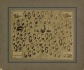
Westminster Branch employees
https://search.heritageburnaby.ca/link/archivedescription36546
- Repository
- City of Burnaby Archives
- Date
- 1905
- Collection/Fonds
- Burnaby Historical Society fonds
- Description Level
- Item
- Physical Description
- 1 photograph : sepia composite ; 19 x 24 cm on board 27 x 32.5 cm
- Scope and Content
- Composite photograph of the employees of the Westminster Branch of the British Columbia Electric Railway Company. A name has been written in pen under many of the photographs: starting at the top left; Neelands, McNel, Wilson, Stuart, Blair, unidentified, Healy, Innes, Rawlison. One row down, five …
- Repository
- City of Burnaby Archives
- Date
- 1905
- Collection/Fonds
- Burnaby Historical Society fonds
- Subseries
- John DeForest subseries
- Physical Description
- 1 photograph : sepia composite ; 19 x 24 cm on board 27 x 32.5 cm
- Description Level
- Item
- Record No.
- 293-007
- Access Restriction
- No restrictions
- Reproduction Restriction
- No known restrictions
- Accession Number
- BHS1992-30
- Scope and Content
- Composite photograph of the employees of the Westminster Branch of the British Columbia Electric Railway Company. A name has been written in pen under many of the photographs: starting at the top left; Neelands, McNel, Wilson, Stuart, Blair, unidentified, Healy, Innes, Rawlison. One row down, five together to the left are; Marsh, Grimmison, Huston, Gregory, Stewart. Four in the center are; Shiles, unidentified, Whitmore, McQuarrie. Five together to the right are; Dickinson, Routley, Thorburn, Monterth, unidentified. Second row down, five together on the left are; Butterfield, Rainey, Alcock, WIlliams, Feeney. Three together in the center are; Glover, Buntzen, Sperling. Four together on the right are; Dunlop and three unidentified.Three rows down, four together on the left are; Reid, Grimmer, McArthur, Brown. Center is unidentified except for Wilson, who is three from the right. Four together on the right are; unidentified, Harris, Ellis, unidentified. Four rows down, three together on the left are; Miller, Featherstone, Williams. The rest of the center are unidentified, and the last three on the right are; McAurthur, Holland, and Hudson. Also included in the composite are two photographs of electric railroad cars, one of the New Westminster shoreline and one of a train station.
- Subjects
- Occupations - Engineers
- Occupations - Railroad Conductors
- Transportation - Electric Railroads
- Media Type
- Photograph
- Photographer
- Okamura, P.L.
- Notes
- Title based on contents of photograph
- Note on recto of composite photograph reads: "~1905~/ PRESENTED TO / J. BUNTZEN ESQ./ BY / THE EMPLOYEES, WESTMINISTER BRANCH B.C.E.RY.CO.LTD."
- Photographer's stamp on recto of board reads: "P. L. OKAMURA NEW WESTMINISTER, B.C."
Images
John DeForest subseries
https://search.heritageburnaby.ca/link/archivedescription73
- Repository
- City of Burnaby Archives
- Date
- 19045[1908]
- Collection/Fonds
- Burnaby Historical Society fonds
- Description Level
- Subseries
- Physical Description
- 7 photographs
- Scope and Content
- Subseries consists of photographs collected by John DeForest that show the Burnaby British Columbia Electric Railway Co. (BCER) substation and employees of the Westminster Branch BCER Company Ltd.
- Repository
- City of Burnaby Archives
- Date
- 19045[1908]
- Collection/Fonds
- Burnaby Historical Society fonds
- Subseries
- John DeForest subseries
- Physical Description
- 7 photographs
- Description Level
- Subseries
- Accession Number
- BHS1992-30
- Scope and Content
- Subseries consists of photographs collected by John DeForest that show the Burnaby British Columbia Electric Railway Co. (BCER) substation and employees of the Westminster Branch BCER Company Ltd.
- Media Type
- Photograph
- Creator
- Deforest, John Albert
- Notes
- Title based on creator of subseries
- PC293

St. John the Divine Anglican Church
https://search.heritageburnaby.ca/link/landmark514
- Repository
- Burnaby Heritage Planning
- Description
- St. John the Divine Anglican Church is a landmark wood-frame Gothic Revival church, with Gothic windows and spire. It is located on Kingsway, one of Burnaby’s main commercial thoroughfares, near the SkyTrain transit line and across the street from Central Park.
- Associated Dates
- 1905
- Formal Recognition
- Community Heritage Register
- Street View URL
- Google Maps Street View
- Repository
- Burnaby Heritage Planning
- Geographic Access
- Kingsway
- Associated Dates
- 1905
- Formal Recognition
- Community Heritage Register
- Enactment Type
- Council Resolution
- Enactment Date
- 09/06/2003
- Description
- St. John the Divine Anglican Church is a landmark wood-frame Gothic Revival church, with Gothic windows and spire. It is located on Kingsway, one of Burnaby’s main commercial thoroughfares, near the SkyTrain transit line and across the street from Central Park.
- Heritage Value
- St. John the Divine Anglican Church is valued as a symbol of the traditions of early Burnaby pioneers and as the oldest surviving church building in the city. Established in 1899, St. John was the first church in the community and was located at a prominent intersection of the old Vancouver-Westminster Road (now Kingsway) and the British Columbia Electric Railway’s interurban station at Central Park. This prominent intersection of the road and rail developed as the town centre of the Central Park district. The first St. John church was destroyed by fire, and was rebuilt at the same location in 1904-05. This church is additionally significant for its association with prominent local architect Joseph Henry Bowman (1864-1943) who emigrated from England in 1888. Bowman was a member of the parish, and designed both the first church and its subsequent replacement. Bowman’s prolific career embraced many stylistic changes and technological advances, and this church is a surviving example of one of his rare religious commissions. The design of the new church's nave and vestry was based on the Gothic Revival style of Christ Church Anglican in Surrey, B.C., which had been the former church of St. John’s incumbent Rev. William Bell. Evolving over time as the congregation grew, the church received a number of early additions, and in 1953 was substantially renovated and enlarged through a new design by Vancouver architect Ross Lort. The original church nave was separated from the tower and turned to allow for a large addition. The congregation relocated to a new church in 1998, and at that time removed the church's memorial windows, leaving behind a number of the original art glass windows installed in the 1920s. The church building was renovated in 2004-05, and surviving original elements were retained and restored, including of the original church tower and interior chancel ceiling. A valued feature of the building is the original cast iron church bell that remains in the tower. It was purchased by the children of the congregation in 1912, and in 1924 was rededicated on Armistice Day as a memorial to Burnaby resident Lt. James Donald McRae Reid, who died in the First World War.
- Defining Elements
- Key elements that define the heritage character of St. John the Divine Anglican Church include its: - location on the north side of Kingsway, opposite Central Park - ecclesiastical form, scale and massing as expressed by the offset tower and tall, gabled roof - tower with its original horizontal wooden drop siding, bellcast square roof with octagonal drum above and bellcast octagonal spire - cedar shingle roof cladding - metal cross at peak of spire - Gothic Revival details such as: Gothic lancet windows with leaded stained glass panels; Gothic entrance door at the base of the tower; pointed-arch louvers in the tower; and exterior gable end scissor-trusses - interior features such as wooden scissor-trusses with diagonal fir tongue and groove panelling on the ceiling above, fir tongue-and-groove panelling on the wall of the nave, and original cedar and fir pews and altar rails - cast iron bell in tower
- Historic Neighbourhood
- Central Park (Historic Neighbourhood)
- Planning Study Area
- Garden Village Area
- Architect
- Joesph Henry Bowman
- Function
- Primary Historic--Place of Worship
- Primary Current--Place of Worship
- Community
- Burnaby
- Cadastral Identifier
- 003-398-871
- Boundaries
- St. John the Divine Anglican Church is comprised of a single institutional lot located at 3891 Kingway, Burnaby.
- Area
- 3486.66
- Contributing Resource
- Building
- Ownership
- Private
- Street Address
- 3891 Kingsway
- Street View URL
- Google Maps Street View
Images


![Tramline tracks, [1905] thumbnail](/media/hpo/_Data/_BVM_Images/1990/199500100001.jpg?width=280)
Tramline tracks
https://search.heritageburnaby.ca/link/museumdescription3361
- Repository
- Burnaby Village Museum
- Date
- [1905]
- Collection/Fonds
- Burnaby Village Museum Photograph collection
- Description Level
- Item
- Physical Description
- 1 photograph : b&w ; 15 x 25.5 cm print
- Scope and Content
- Photograph of a British Columbia Electric Railway Company tramline track on Sixth Street and Twelfth Avenue. George Leaf's General Store, located at 7745 Sixth Street is visible on the left and Cliff's Car Factory located at 7730 Sixth Street is visible on the right. George Leaf's store burned down…
- Repository
- Burnaby Village Museum
- Collection/Fonds
- Burnaby Village Museum Photograph collection
- Description Level
- Item
- Physical Description
- 1 photograph : b&w ; 15 x 25.5 cm print
- Scope and Content
- Photograph of a British Columbia Electric Railway Company tramline track on Sixth Street and Twelfth Avenue. George Leaf's General Store, located at 7745 Sixth Street is visible on the left and Cliff's Car Factory located at 7730 Sixth Street is visible on the right. George Leaf's store burned down in 1913. The Car factory was established in 1902 and sometime in the 1920s, it became James Brookes Woodworking Plant.
- Subjects
- Transportation - Electric Railroads
- Buildings - Commercial - General Stores
- Buildings - Industrial - Factories
- Geographic Access
- 6th Street
- 12th Avenue
- Street Address
- 7730 6th Street
- 7745 6th Street
- Accession Code
- BV995.10.1
- Access Restriction
- No restrictions
- Date
- [1905]
- Media Type
- Photograph
- Historic Neighbourhood
- East Burnaby (Historic Neighbourhood)
- Planning Study Area
- Edmonds Area
- Notes
- Title based on contents of photograph
Images
![Tramline tracks, [1905] thumbnail](/media/hpo/_Data/_BVM_Images/1990/199500100001.jpg)
![Burnaby Substation, [September 1907] thumbnail](/media/hpo/_Data/_Archives_Images/_Unrestricted/251/293-002.jpg?width=280)
Burnaby Substation
https://search.heritageburnaby.ca/link/archivedescription36541
- Repository
- City of Burnaby Archives
- Date
- [September 1907]
- Collection/Fonds
- Burnaby Historical Society fonds
- Description Level
- Item
- Physical Description
- 1 photograph : b&w postcard ; 7.5 x 13 cm
- Scope and Content
- Photographic postcard of the British Columbia Electric Railway Company's Burnaby Substation that was built in 1903 and put into operation to receive and distribute power from the B.C.E.R. Buntzen Lake power dam. The electric lines came across the inlet at Barnet, along the Barnet-Hastings Road to S…
- Repository
- City of Burnaby Archives
- Date
- [September 1907]
- Collection/Fonds
- Burnaby Historical Society fonds
- Subseries
- John DeForest subseries
- Physical Description
- 1 photograph : b&w postcard ; 7.5 x 13 cm
- Description Level
- Item
- Record No.
- 293-002
- Access Restriction
- No restrictions
- Reproduction Restriction
- No known restrictions
- Accession Number
- BHS1992-30
- Scope and Content
- Photographic postcard of the British Columbia Electric Railway Company's Burnaby Substation that was built in 1903 and put into operation to receive and distribute power from the B.C.E.R. Buntzen Lake power dam. The electric lines came across the inlet at Barnet, along the Barnet-Hastings Road to Sperling Avenue (built for this project and called Pole Line Road) and then south to this site at the corner of Griffiths and the old Central Park interurban line (later this section was called the Highland Park line). This substation was constructed to convert the alternating current being delivered from the Buntzen power plant to direct current for the operation of the tram cars operating on the Central Park interurban route. The new brick substation replaced the wood fed steam powered 1891 Powerhouse that operated south of this site, across the tracks until its closure on May 31,1905. It was demolised in the late 1920s. This brick substation originally known as the Burnaby Substation, eventually became known as the Newell Substation. The original brick building was replaced by a new structure in 1930, which was demolished in the 1960s in favour of the open field substation that continues to operate on the same site today at 7260 Griffiths Avenue.
- Subjects
- Buildings - Industrial - Powerhouses
- Media Type
- Photograph
- Notes
- Title based on contents of photograph
- Geographic Access
- Griffiths Avenue
- Historic Neighbourhood
- Edmonds (Historic Neighbourhood)
- Planning Study Area
- Stride Avenue Area
Images
![Burnaby Substation, [September 1907] thumbnail](/media/hpo/_Data/_Archives_Images/_Unrestricted/251/293-002.jpg)

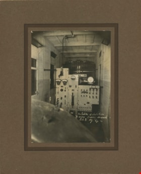
Interior of the Burnaby Substation
https://search.heritageburnaby.ca/link/archivedescription36544
- Repository
- City of Burnaby Archives
- Date
- 1907
- Collection/Fonds
- Burnaby Historical Society fonds
- Description Level
- Item
- Physical Description
- 1 photograph : sepia ; 12 x 17cm, mounted on board 22 x 27 cm
- Scope and Content
- Photograph of the interior of the British Columbia Electric Railway Company's Burnaby Substation that was built in 1903 and put into operation to receive and distribute power from the B.C.E.R. Buntzen Lake power dam. The electric lines came across the inlet at Barnet, along the Barnet-Hastings Road…
- Repository
- City of Burnaby Archives
- Date
- 1907
- Collection/Fonds
- Burnaby Historical Society fonds
- Subseries
- John DeForest subseries
- Physical Description
- 1 photograph : sepia ; 12 x 17cm, mounted on board 22 x 27 cm
- Description Level
- Item
- Record No.
- 293-005
- Access Restriction
- No restrictions
- Reproduction Restriction
- No known restrictions
- Accession Number
- BHS1992-30
- Scope and Content
- Photograph of the interior of the British Columbia Electric Railway Company's Burnaby Substation that was built in 1903 and put into operation to receive and distribute power from the B.C.E.R. Buntzen Lake power dam. The electric lines came across the inlet at Barnet, along the Barnet-Hastings Road to Sperling Avenue (built for this project and called Pole Line Road) and then south to this site at the corner of Griffiths and the old Central Park interurban line (later this section was called the Highland Park line). This substation was constructed to convert the alternating current being delivered from the Buntzen power plant to direct current for the operation of the tram cars operating on the Central Park interurban route. The new brick substation replaced the wood fed steam powered 1891 Powerhouse that operated south of this site, across the tracks until its closure on May 31,1905. It was demolised in the late 1920s. This brick substation originally known as the Burnaby Substation, eventually became known as the Newell Substation. The original brick building was replaced by a new structure in 1930, which was demolished in the 1960s in favour of the open field substation that continues to operate on the same site today at 7260 Griffiths Avenue.
- Subjects
- Buildings - Industrial - Powerhouses
- Media Type
- Photograph
- Notes
- Title based on contents of photograph
- Photographer's handwritten note (on the negative causing it to show) on recto of photograph reads: "Burnaby Substation/ B.C.E.R.C/O"
- Geographic Access
- Griffiths Avenue
- Historic Neighbourhood
- Edmonds (Historic Neighbourhood)
- Planning Study Area
- Stride Avenue Area
Images

Portable substation at the Fraser Valley branch
https://search.heritageburnaby.ca/link/archivedescription36545
- Repository
- City of Burnaby Archives
- Date
- 1907
- Collection/Fonds
- Burnaby Historical Society fonds
- Description Level
- Item
- Physical Description
- 1 photograph : sepia ; 17 x 12cm, mounted on board 27 x 22 cm
- Scope and Content
- Photograph of the interior of the portable "railcar" substation at the British Columbia Electric Railway Company's Fraser Valley Branch.
- Repository
- City of Burnaby Archives
- Date
- 1907
- Collection/Fonds
- Burnaby Historical Society fonds
- Subseries
- John DeForest subseries
- Physical Description
- 1 photograph : sepia ; 17 x 12cm, mounted on board 27 x 22 cm
- Description Level
- Item
- Record No.
- 293-006
- Access Restriction
- No restrictions
- Reproduction Restriction
- No known restrictions
- Accession Number
- BHS1992-30
- Scope and Content
- Photograph of the interior of the portable "railcar" substation at the British Columbia Electric Railway Company's Fraser Valley Branch.
- Subjects
- Buildings - Industrial - Powerhouses
- Media Type
- Photograph
- Notes
- Title based on contents of photograph
- Photographer's handwritten note (on the negative causing it to show) on recto of photograph reads: "Burnaby Substation/ B.C.E.R.C/O"
Images

Brian Elder subseries
https://search.heritageburnaby.ca/link/archivedescription97415
- Repository
- City of Burnaby Archives
- Date
- 1908 (date of original)-1936 (date of original)
- Collection/Fonds
- Burnaby Historical Society fonds
- Description Level
- Subseries
- Physical Description
- Textual records
- Scope and Content
- Subseries consists of copies of records compiled by Brian Elder on the history of the British Columbia Electric Railway (BCER).
- Repository
- City of Burnaby Archives
- Date
- 1908 (date of original)-1936 (date of original)
- Collection/Fonds
- Burnaby Historical Society fonds
- Subseries
- Brian Elder subseries
- Physical Description
- Textual records
- Description Level
- Subseries
- Accession Number
- BHS1996-23
- BHS2001-01
- Scope and Content
- Subseries consists of copies of records compiled by Brian Elder on the history of the British Columbia Electric Railway (BCER).
- History
- Brian Elder was a restoration volunteer for Friends of Interurban 1223.
- Media Type
- Textual Record
- Creator
- Elder, Brian
- Notes
- Title based on creator of subseries
![Interior of the Burnaby Substation, [September 1908] thumbnail](/media/hpo/_Data/_Archives_Images/_Unrestricted/251/293-003.jpg?width=280)
Interior of the Burnaby Substation
https://search.heritageburnaby.ca/link/archivedescription36542
- Repository
- City of Burnaby Archives
- Date
- [September 1908]
- Collection/Fonds
- Burnaby Historical Society fonds
- Description Level
- Item
- Physical Description
- 1 photograph : b&w postcard ; 7.5 x 13 cm
- Scope and Content
- Photographic postcard of the interior of the British Columbia Electric Railway Company's Burnaby Substation that was built in 1903 and put into operation to receive and distribute power from the B.C.E.R. Buntzen Lake power dam. The electric lines came across the inlet at Barnet, along the Barnet-Ha…
- Repository
- City of Burnaby Archives
- Date
- [September 1908]
- Collection/Fonds
- Burnaby Historical Society fonds
- Subseries
- John DeForest subseries
- Physical Description
- 1 photograph : b&w postcard ; 7.5 x 13 cm
- Description Level
- Item
- Record No.
- 293-003
- Access Restriction
- No restrictions
- Reproduction Restriction
- No known restrictions
- Accession Number
- BHS1992-30
- Scope and Content
- Photographic postcard of the interior of the British Columbia Electric Railway Company's Burnaby Substation that was built in 1903 and put into operation to receive and distribute power from the B.C.E.R. Buntzen Lake power dam. The electric lines came across the inlet at Barnet, along the Barnet-Hastings Road to Sperling Avenue (built for this project and called Pole Line Road) and then south to this site at the corner of Griffiths and the old Central Park interurban line (later this section was called the Highland Park line). This substation was constructed to convert the alternating current being delivered from the Buntzen power plant to direct current for the operation of the tram cars operating on the Central Park interurban route. The new brick substation replaced the wood fed steam powered 1891 Powerhouse that operated south of this site, across the tracks until its closure on May 31,1905. It was demolised in the late 1920s. This brick substation originally known as the Burnaby Substation, eventually became known as the Newell Substation. The original brick building was replaced by a new structure in 1930, which was demolished in the 1960s in favour of the open field substation that continues to operate on the same site today at 7260 Griffiths Avenue.
- Subjects
- Buildings - Industrial - Powerhouses
- Media Type
- Photograph
- Notes
- Title based on contents of photograph
- Geographic Access
- Griffiths Avenue
- Historic Neighbourhood
- Edmonds (Historic Neighbourhood)
- Planning Study Area
- Stride Avenue Area
Images
![Interior of the Burnaby Substation, [September 1908] thumbnail](/media/hpo/_Data/_Archives_Images/_Unrestricted/251/293-003.jpg)
![Interior of the Burnaby Substation, [September 1908] thumbnail](/media/hpo/_Data/_Archives_Images/_Unrestricted/251/293-004.jpg?width=280)
Interior of the Burnaby Substation
https://search.heritageburnaby.ca/link/archivedescription36543
- Repository
- City of Burnaby Archives
- Date
- [September 1908]
- Collection/Fonds
- Burnaby Historical Society fonds
- Description Level
- Item
- Physical Description
- 1 photograph : b&w postcard ; 7.5 x 13 cm
- Scope and Content
- Photographic postcard of the interior of the British Columbia Electric Railway Company's Burnaby Substation that was built in 1903 and put into operation to receive and distribute power from the B.C.E.R. Buntzen Lake power dam. The electric lines came across the inlet at Barnet, along the Barnet-Ha…
- Repository
- City of Burnaby Archives
- Date
- [September 1908]
- Collection/Fonds
- Burnaby Historical Society fonds
- Subseries
- John DeForest subseries
- Physical Description
- 1 photograph : b&w postcard ; 7.5 x 13 cm
- Description Level
- Item
- Record No.
- 293-004
- Access Restriction
- No restrictions
- Reproduction Restriction
- No known restrictions
- Accession Number
- BHS1992-30
- Scope and Content
- Photographic postcard of the interior of the British Columbia Electric Railway Company's Burnaby Substation that was built in 1903 and put into operation to receive and distribute power from the B.C.E.R. Buntzen Lake power dam. The electric lines came across the inlet at Barnet, along the Barnet-Hastings Road to Sperling Avenue (built for this project and called Pole Line Road) and then south to this site at the corner of Griffiths and the old Central Park interurban line (later this section was called the Highland Park line). This substation was constructed to convert the alternating current being delivered from the Buntzen power plant to direct current for the operation of the tram cars operating on the Central Park interurban route. The new brick substation replaced the wood fed steam powered 1891 Powerhouse that operated south of this site, across the tracks until its closure on May 31,1905. It was demolised in the late 1920s. This brick substation originally known as the Burnaby Substation, eventually became known as the Newell Substation. The original brick building was replaced by a new structure in 1930, which was demolished in the 1960s in favour of the open field substation that continues to operate on the same site today at 7260 Griffiths Avenue.
- Subjects
- Buildings - Industrial - Powerhouses
- Media Type
- Photograph
- Notes
- Title based on contents of photograph
- Geographic Access
- Griffiths Avenue
- Historic Neighbourhood
- Edmonds (Historic Neighbourhood)
- Planning Study Area
- Stride Avenue Area
Images
![Interior of the Burnaby Substation, [September 1908] thumbnail](/media/hpo/_Data/_Archives_Images/_Unrestricted/251/293-004.jpg)
Burnaby Municipality - Railway Franchises and Extensions
https://search.heritageburnaby.ca/link/archivedescription65738
- Repository
- City of Burnaby Archives
- Date
- 1908-1910 (date of originals)
- Collection/Fonds
- Burnaby Historical Society fonds
- Description Level
- File
- Physical Description
- 1 file of textual records (photocopies)
- Scope and Content
- File consists of photocopied pages from a ledger describing telephone calls and decisions made regarding British Columbia Electric Railway "Franchises and Extensions" within the Municipality of Burnaby.
- Repository
- City of Burnaby Archives
- Date
- 1908-1910 (date of originals)
- Collection/Fonds
- Burnaby Historical Society fonds
- Subseries
- Brian Elder subseries
- Physical Description
- 1 file of textual records (photocopies)
- Description Level
- File
- Record No.
- 42660
- Accession Number
- BHS2001-01
- Scope and Content
- File consists of photocopied pages from a ledger describing telephone calls and decisions made regarding British Columbia Electric Railway "Franchises and Extensions" within the Municipality of Burnaby.
- Media Type
- Textual Record
- Notes
- Transcribed title
![Interurban tram at Steveston, [1908] thumbnail](/media/hpo/_Data/_BVM_Images/1985/198800070006.jpg?width=280)
Interurban tram at Steveston
https://search.heritageburnaby.ca/link/museumdescription88
- Repository
- Burnaby Village Museum
- Date
- [1908]
- Collection/Fonds
- Burnaby Village Museum Photograph collection
- Description Level
- Item
- Physical Description
- 1 photograph : b&w ; 19.5 x 24.5 cm print
- Scope and Content
- Photograph of British Columbia Electric Railway Company interurban tram "RICHMOND" at Steveston (the tram would later be called no. 1205). The tram is bound for Vancouver and loaded with passengers. Three men (two wearing conductor's uniforms) are standing near the front door of the tram, facing th…
- Repository
- Burnaby Village Museum
- Collection/Fonds
- Burnaby Village Museum Photograph collection
- Description Level
- Item
- Physical Description
- 1 photograph : b&w ; 19.5 x 24.5 cm print
- Scope and Content
- Photograph of British Columbia Electric Railway Company interurban tram "RICHMOND" at Steveston (the tram would later be called no. 1205). The tram is bound for Vancouver and loaded with passengers. Three men (two wearing conductor's uniforms) are standing near the front door of the tram, facing the camera.
- Subjects
- Transportation - Electric Railroads
- Accession Code
- BV988.7.6
- Access Restriction
- No restrictions
- Reproduction Restriction
- No known restrictions
- Date
- [1908]
- Media Type
- Photograph
- Scan Resolution
- 600
- Scan Date
- 01-Jun-09
- Scale
- 100
- Notes
- Title based on contents of photograph
- Note on verso of photograph reads: "RICHMOND" (later # 1205) at Steveston about 1908" and "H. EWERT photo [mailing address follows]"
Images
![Interurban tram at Steveston, [1908] thumbnail](/media/hpo/_Data/_BVM_Images/1985/198800070006.jpg)
![Survey and Subdivision plans in New Westminster District Group 1 – Burnaby
, [1908] thumbnail](/media/hpo/_Data/_BVM_Cartographic_Material/1977/1977_0093_0004a_001.jpg?width=280)
Survey and Subdivision plans in New Westminster District Group 1 – Burnaby
https://search.heritageburnaby.ca/link/museumdescription6973
- Repository
- Burnaby Village Museum
- Date
- [1908]
- Collection/Fonds
- Burnaby Village Museum Map collection
- Description Level
- File
- Physical Description
- 10 plans : blueprint ink on paper mounted on 2 sides of cardboard ; 76 cm x 102 cm
- Scope and Content
- Item consists of a large board of four New Westminster District Gp 1 - subdivision plans mounted on one side and six New Westminster District Gp 1 - subdivision plans mounted on the other side. Side A: 1. Blueprint "Plan / of - ReSubdivision / of / Lots 1-18 inclusive / Blocks 20 and 21 / in Sub…
- Repository
- Burnaby Village Museum
- Collection/Fonds
- Burnaby Village Museum Map collection
- Description Level
- File
- Physical Description
- 10 plans : blueprint ink on paper mounted on 2 sides of cardboard ; 76 cm x 102 cm
- Material Details
- Scales [between 1:792 and 1:4752]
- Index number on edge of board reads: "4"
- Scope and Content
- Item consists of a large board of four New Westminster District Gp 1 - subdivision plans mounted on one side and six New Westminster District Gp 1 - subdivision plans mounted on the other side. Side A: 1. Blueprint "Plan / of - ReSubdivision / of / Lots 1-18 inclusive / Blocks 20 and 21 / in Subdivision / of / Lot 53 -Gr.1 / New Westminster District" / "Subdivision Lot Numbers - Shown in Red". Plan is bordered by First Street / Jorgenson's Line / Fourth Avenue and Second Street with Fifith Avenue running through the centre. There is an index in the upper right corner of the plan. Planned is signed by "Peter Byrne" and "William R. Phillips" and dated July 28, 1908. (Geographic location: Burnaby) 2. Blueprint "Plan / of Subdivision / of / Lot 159 / and a Portion of Lot 158 / Group One / New Westminster District". Plan is bordered by Lots 96 and 97; South Wilson Street; North Arm Road and Lot 160 / Power House Road (Lot 155 A). B.C.E.R. Gilley Station is identified in the upper right corner of the plan. (Geographic location: Burnaby) 3. Blueprint plan identified as "Subdvs 10, L 88 and Lot 25, G. 1" Plan identifies Cumberland Street running from top to the bottom and a Ravine running alongside with the Jensen house, stable and barn. (Geographic location: Burnaby) 4. Blueprint Plan of "Lot 153. G. 1 /New Westminster District". Plan identifies the "New Westminster & Vancouver Tramway" and the "New Westminster and Vancouver Road" running through the plan of Lot 53. (Geographic location: Burnaby) Side B: 1. Blueprint plan of "Profile on Proposed North Rd. Diversion". 2. Blueprint plan (no title) showing wood lots north of Burnaby Lake and Brunette River and west of North Road. Various lots are identified as "Heavily Timbered" (Lot 57); "Splendid Fir and Cedar / Heavy Fir etc. / Fine Cedar" (Lots 143, 148); "Rough Light Timber," (Lot 56); "Some Fir and Cedar" (Lot 40). (Geographic location: Burnaby) 3. Blueprint "Plan / of Subdivision / of a Portion / of Lot 87, Gr.1 / New Westminster District". Plan is bordered by Burnaby Lake at the top and Hastings Road / Lot 86 at the bottom and Lot 90 to the east. "Albert J. Hill B.C.LotS." Annotation in ink reads: " J.A. Brownlee, B.C.L.S. / Subdivision / Map 1494 / Bd. 248". Plan is signed by "Peter Byrne, Reeve" (Geographic location: Burnaby) 4. Blueprint plan of Subdivisions along either side of Douglas Road including Lots 117; 119; 74; 80; 79 and 77. (Geographic location: Burnaby) 5. Blueprint "Plan / of / Subdivision of / Lot 27 / in Subdivision / of / Lot 30 / Group One / New Westminster District" Plan is bordered by Lot 26, Lot 28 and Hastings Rd. Lot 27 runs north of Edmonds Street. , "Albert J. Hill, B.C.LotS." (Geographic location: Burnaby) 6. Blueprint plan identified as a "Cultivated Orchard" including the names "W. Grace" and "G. Mead" located north of the North Arm Fraser River and west of "Twentieth Street_ City Boundary". Handwritten annotation in coloured pencil reads: "Portion of Lot 172" (Geographic location: Burnaby)
- Subjects
- Geographic Features - Forests
- Geographic Access
- Cumberland Street
- North Road
- Hastings Street
- Douglas Road
- Accession Code
- HV977.93.4
- Access Restriction
- No restrictions
- Reproduction Restriction
- No known restrictions
- Date
- [1908]
- Media Type
- Cartographic Material
- Historic Neighbourhood
- Burnaby Lake (Historic Neighbourhood)
- Fraser Arm (Historic Neighbourhood)
- Planning Study Area
- Douglas-Gilpin Area
- Burnaby Lake Area
- Scan Resolution
- 300
- Scale
- 72
- Notes
- Title based on contents of file
- Scale is measured in chains. (One chain equals 792 inches)
- The term "Lot" can also refer to a "District Lot”-
Images
![Survey and Subdivision plans in New Westminster District Group 1 – Burnaby
, [1908] thumbnail](/media/hpo/_Data/_BVM_Cartographic_Material/1977/1977_0093_0004a_001.jpg)

![Grace McGhee, [1909] (date of original), copied 1986 thumbnail](/media/hpo/_Data/_Archives_Images/_Unrestricted/204/204-010.jpg?width=280)
Grace McGhee
https://search.heritageburnaby.ca/link/archivedescription35153
- Repository
- City of Burnaby Archives
- Date
- [1909] (date of original), copied 1986
- Collection/Fonds
- Burnaby Historical Society fonds
- Description Level
- Item
- Physical Description
- 1 photograph : b&w ; 12.7 x 17.8 cm print
- Scope and Content
- Photograph of Grace McGhee (nee George) at McKay station along the Central Park Interurban line.
- Repository
- City of Burnaby Archives
- Date
- [1909] (date of original), copied 1986
- Collection/Fonds
- Burnaby Historical Society fonds
- Subseries
- Pioneer Tales subseries
- Physical Description
- 1 photograph : b&w ; 12.7 x 17.8 cm print
- Description Level
- Item
- Record No.
- 204-010
- Access Restriction
- No restrictions
- Reproduction Restriction
- No known restrictions
- Accession Number
- BHS1988-03
- Scope and Content
- Photograph of Grace McGhee (nee George) at McKay station along the Central Park Interurban line.
- Media Type
- Photograph
- Notes
- Title based on contents of photograph
- Geographic Access
- McKay Avenue
- Central Park Interurban line
- Historic Neighbourhood
- Central Park (Historic Neighbourhood)
- Planning Study Area
- Maywood Area
Images
![Grace McGhee, [1909] (date of original), copied 1986 thumbnail](/media/hpo/_Data/_Archives_Images/_Unrestricted/204/204-010.jpg)

BCER Eburne Line
https://search.heritageburnaby.ca/link/landmark771
- Repository
- Burnaby Heritage Planning
- Associated Dates
- 1909
- Heritage Value
- In 1908, construction began on the British Columbia Electric Railway Eburne tramline which was to connect Eburne (now known as Marpole) with New Westminster. It opened on September 15, 1909 and its tracks were built across the bog of the Fraser Arm district with little regard to the fact that virtually no one lived there. However, within one year an hourly passenger service, a milk train and three-times weekly freight service used this level fast-running connector. With the completion of the Chilliwack interurban line and various other steam railroads which were funnelled onto this line it became one of the most important industrial freight lines in the Lower Mainland.
- Historic Neighbourhood
- Fraser Arm (Historic Neighbourhood)
- Planning Study Area
- Big Bend Area
Images

British Columbia Electric Railway (BCER) Franchise
https://search.heritageburnaby.ca/link/councilreport74612
- Repository
- City of Burnaby Archives
- Report ID
- 80551
- Meeting Date
- 16-Aug-1909
- Format
- Council - Mayor/Councillor/Staff Report
- Collection/Fonds
- City Council and Office of the City Clerk fonds
- Repository
- City of Burnaby Archives
- Report ID
- 80551
- Meeting Date
- 16-Aug-1909
- Format
- Council - Mayor/Councillor/Staff Report
- Collection/Fonds
- City Council and Office of the City Clerk fonds