Narrow Results By
![Survey and Subdivision plans in New Westminster District Group 1 – Burnaby
, [1908] thumbnail](/media/hpo/_Data/_BVM_Cartographic_Material/1977/1977_0093_0004a_001.jpg?width=280)
Survey and Subdivision plans in New Westminster District Group 1 – Burnaby
https://search.heritageburnaby.ca/link/museumdescription6973
- Repository
- Burnaby Village Museum
- Date
- [1908]
- Collection/Fonds
- Burnaby Village Museum Map collection
- Description Level
- File
- Physical Description
- 10 plans : blueprint ink on paper mounted on 2 sides of cardboard ; 76 cm x 102 cm
- Scope and Content
- Item consists of a large board of four New Westminster District Gp 1 - subdivision plans mounted on one side and six New Westminster District Gp 1 - subdivision plans mounted on the other side. Side A: 1. Blueprint "Plan / of - ReSubdivision / of / Lots 1-18 inclusive / Blocks 20 and 21 / in Sub…
- Repository
- Burnaby Village Museum
- Collection/Fonds
- Burnaby Village Museum Map collection
- Description Level
- File
- Physical Description
- 10 plans : blueprint ink on paper mounted on 2 sides of cardboard ; 76 cm x 102 cm
- Material Details
- Scales [between 1:792 and 1:4752]
- Index number on edge of board reads: "4"
- Scope and Content
- Item consists of a large board of four New Westminster District Gp 1 - subdivision plans mounted on one side and six New Westminster District Gp 1 - subdivision plans mounted on the other side. Side A: 1. Blueprint "Plan / of - ReSubdivision / of / Lots 1-18 inclusive / Blocks 20 and 21 / in Subdivision / of / Lot 53 -Gr.1 / New Westminster District" / "Subdivision Lot Numbers - Shown in Red". Plan is bordered by First Street / Jorgenson's Line / Fourth Avenue and Second Street with Fifith Avenue running through the centre. There is an index in the upper right corner of the plan. Planned is signed by "Peter Byrne" and "William R. Phillips" and dated July 28, 1908. (Geographic location: Burnaby) 2. Blueprint "Plan / of Subdivision / of / Lot 159 / and a Portion of Lot 158 / Group One / New Westminster District". Plan is bordered by Lots 96 and 97; South Wilson Street; North Arm Road and Lot 160 / Power House Road (Lot 155 A). B.C.E.R. Gilley Station is identified in the upper right corner of the plan. (Geographic location: Burnaby) 3. Blueprint plan identified as "Subdvs 10, L 88 and Lot 25, G. 1" Plan identifies Cumberland Street running from top to the bottom and a Ravine running alongside with the Jensen house, stable and barn. (Geographic location: Burnaby) 4. Blueprint Plan of "Lot 153. G. 1 /New Westminster District". Plan identifies the "New Westminster & Vancouver Tramway" and the "New Westminster and Vancouver Road" running through the plan of Lot 53. (Geographic location: Burnaby) Side B: 1. Blueprint plan of "Profile on Proposed North Rd. Diversion". 2. Blueprint plan (no title) showing wood lots north of Burnaby Lake and Brunette River and west of North Road. Various lots are identified as "Heavily Timbered" (Lot 57); "Splendid Fir and Cedar / Heavy Fir etc. / Fine Cedar" (Lots 143, 148); "Rough Light Timber," (Lot 56); "Some Fir and Cedar" (Lot 40). (Geographic location: Burnaby) 3. Blueprint "Plan / of Subdivision / of a Portion / of Lot 87, Gr.1 / New Westminster District". Plan is bordered by Burnaby Lake at the top and Hastings Road / Lot 86 at the bottom and Lot 90 to the east. "Albert J. Hill B.C.LotS." Annotation in ink reads: " J.A. Brownlee, B.C.L.S. / Subdivision / Map 1494 / Bd. 248". Plan is signed by "Peter Byrne, Reeve" (Geographic location: Burnaby) 4. Blueprint plan of Subdivisions along either side of Douglas Road including Lots 117; 119; 74; 80; 79 and 77. (Geographic location: Burnaby) 5. Blueprint "Plan / of / Subdivision of / Lot 27 / in Subdivision / of / Lot 30 / Group One / New Westminster District" Plan is bordered by Lot 26, Lot 28 and Hastings Rd. Lot 27 runs north of Edmonds Street. , "Albert J. Hill, B.C.LotS." (Geographic location: Burnaby) 6. Blueprint plan identified as a "Cultivated Orchard" including the names "W. Grace" and "G. Mead" located north of the North Arm Fraser River and west of "Twentieth Street_ City Boundary". Handwritten annotation in coloured pencil reads: "Portion of Lot 172" (Geographic location: Burnaby)
- Subjects
- Geographic Features - Forests
- Geographic Access
- Cumberland Street
- North Road
- Hastings Street
- Douglas Road
- Accession Code
- HV977.93.4
- Access Restriction
- No restrictions
- Reproduction Restriction
- No known restrictions
- Date
- [1908]
- Media Type
- Cartographic Material
- Historic Neighbourhood
- Burnaby Lake (Historic Neighbourhood)
- Fraser Arm (Historic Neighbourhood)
- Planning Study Area
- Douglas-Gilpin Area
- Burnaby Lake Area
- Scan Resolution
- 300
- Scale
- 72
- Notes
- Title based on contents of file
- Scale is measured in chains. (One chain equals 792 inches)
- The term "Lot" can also refer to a "District Lot”-
Images
![Survey and Subdivision plans in New Westminster District Group 1 – Burnaby
, [1908] thumbnail](/media/hpo/_Data/_BVM_Cartographic_Material/1977/1977_0093_0004a_001.jpg)


card
https://search.heritageburnaby.ca/link/museumartifact18276
- Repository
- Burnaby Village Museum
- Accession Code
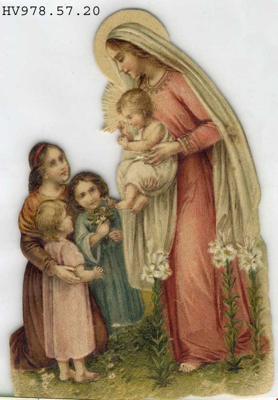
- HV978.57.20
- Description
- Virgin Mary and Jesus - Card. Cut-out paper coloured and embossed of Virgin Mary and Jesus with three children. Handwritten on the back is "Miss Norah Byrne"
- Object History
- From the estate of Norah Byrne, daughter of Peter Byrne and Priscilla Amelia Rowling Rowling. She married William Napoleon Descoteau on May 28th 1924 in New Westminster. William worked as a steam engineer on the railroad.
Images

card
https://search.heritageburnaby.ca/link/museumartifact18278
- Repository
- Burnaby Village Museum
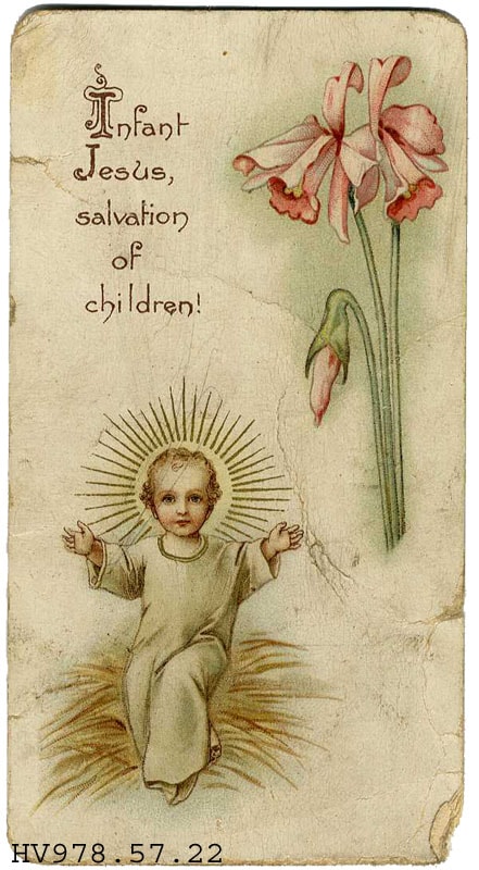
- Accession Code
- HV978.57.22
- Description
- Infant Jesus - Card. Religious card of an infant Jesus and flowers. Above the image is "Infant Jesus salvation of children!" written in script.
- Object History
- From the estate of Norah Byrne, daughter of Peter Byrne and Priscilla Amelia Rowling Rowling. She married William Napoleon Descoteau on May 28th 1924 in New Westminster. William worked as a steam engineer on the railroad.
Images
card
https://search.heritageburnaby.ca/link/museumartifact18281
- Repository
- Burnaby Village Museum
- Accession Code
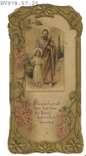
- HV978.57.25
- Description
- Blessed are all - Card. St. Joseph prayer card with an image of St. Joseph with a child Jesus on the front and "Blessed are all they that fear the Lord: that walk in his ways" written below. On the reverse is a passage from Psalms.
- Object History
- From the estate of Norah Byrne, daughter of Peter Byrne and Priscilla Amelia Rowling Rowling. She married William Napoleon Descoteau on May 28th 1924 in New Westminster. William worked as a steam engineer on the railroad.
Images


greeting card
https://search.heritageburnaby.ca/link/museumartifact18275
- Repository
- Burnaby Village Museum
- Accession Code
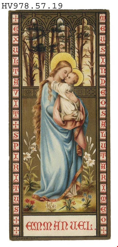
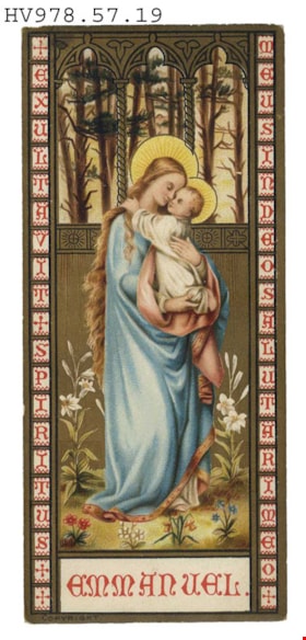
- HV978.57.19
- Description
- Emmanuel - Card. Christmas greeting with a coloured picture of Virgin Mary and infant Jesus with flowers infront of a wall with three windows with trees visible through them. At the bottom of the card "EMMANUEL." is written in red script. Down the left side of card is "EXULTAVIT SPIRITUS", down right side is "MEUSINDEOSALUTARIMEO". On reverse is "With CHRISTMAS Greeting"
- Object History
- From the estate of Norah Byrne, daughter of Peter Byrne and Priscilla Amelia Rowling Rowling. She married William Napoleon Descoteau on May 28th 1924 in New Westminster. William worked as a steam engineer on the railroad.
Images