Narrow Results By
Subject
- Agricultural Tools and Equipment 1
- Agriculture - Farms 1
- Animals - Dogs 1
- Buildings - Residential - Houses 1
- Documentary Artifacts - Portraits 1
- Geographic Features - Forests 1
- Geographic Features - Rivers 1
- Industries - Forestry 2
- Industries - Logging/lumber 2
- Occupations - Lumberjacks 2
- Officials - Alderman and Councillors 1
- Officials - Mayors and Reeves 4
Frederick Thrussell and Peter Byrne
https://search.heritageburnaby.ca/link/archivedescription36471
- Repository
- City of Burnaby Archives
- Date
- 1893 (date of original)
- Collection/Fonds
- Burnaby Historical Society fonds
- Description Level
- Item
- Physical Description
- 1 photograph : b&w ; 10 x 8.5 cm print
- Scope and Content
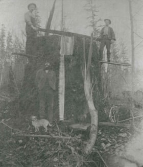
- Photograph of Frederick Thrussell in a three-piece suit and hat, standing in front of a large stump. A small dog stands in front of him, and a crosscut saw is to his left, propped up vertically against the stump. Peter Byrne stands on a spring board protruding from the stump, and holds on to the en…
- Repository
- City of Burnaby Archives
- Date
- 1893 (date of original)
- Collection/Fonds
- Burnaby Historical Society fonds
- Subseries
- Thrussell family subseries
- Physical Description
- 1 photograph : b&w ; 10 x 8.5 cm print
- Description Level
- Item
- Record No.
- 275-002
- Access Restriction
- No restrictions
- Reproduction Restriction
- No known restrictions
- Accession Number
- BHS1992-05
- Scope and Content
- Photograph of Frederick Thrussell in a three-piece suit and hat, standing in front of a large stump. A small dog stands in front of him, and a crosscut saw is to his left, propped up vertically against the stump. Peter Byrne stands on a spring board protruding from the stump, and holds on to the end of a second crosscut saw. On the other side of the stump, a man balances on a second spring board while holding on to the opposite end of the horizontal crosscut saw with this right hand. Peter Byrne went on to serve as a member of Council from 1894 to 1895 and from 1898 to 1906, and was Reeve of Burnaby from 1906 to 1910.
- Subjects
- Occupations - Lumberjacks
- Officials - Mayors and Reeves
- Industries - Forestry
- Woodworking Tools and Equipment
- Animals - Dogs
- Industries - Logging/lumber
- Media Type
- Photograph
- Notes
- Title based on contents of photograph
Images

![Frederick Thrussell and Peter Byrne by a fallen tree, [1893] thumbnail](/media/hpo/_Data/_Archives_Images/_Unrestricted/316/316-010.jpg?width=280)
Frederick Thrussell and Peter Byrne by a fallen tree
https://search.heritageburnaby.ca/link/archivedescription37104
- Repository
- City of Burnaby Archives
- Date
- [1893]
- Collection/Fonds
- Burnaby Historical Society fonds
- Description Level
- Item
- Physical Description
- 1 photograph : b&w ; 15 x 10 cm print
- Scope and Content
- Photograph of Frederick Thrussell, unidentified, and Peter Byrne standing in front of a large fallen tree. A crosscut saw is propped up vertically against the end of the felled tree. Peter Byrne was Reeve of Burnaby from 1906 to 1910. Earlier, he also served as a member of Council from 1894 to 1895…
- Repository
- City of Burnaby Archives
- Date
- [1893]
- Collection/Fonds
- Burnaby Historical Society fonds
- Subseries
- Byrne family subseries
- Physical Description
- 1 photograph : b&w ; 15 x 10 cm print
- Description Level
- Item
- Record No.
- 316-010
- Access Restriction
- No restrictions
- Reproduction Restriction
- No known restrictions
- Accession Number
- BHS1995-04
- Scope and Content
- Photograph of Frederick Thrussell, unidentified, and Peter Byrne standing in front of a large fallen tree. A crosscut saw is propped up vertically against the end of the felled tree. Peter Byrne was Reeve of Burnaby from 1906 to 1910. Earlier, he also served as a member of Council from 1894 to 1895 and from 1898 to 1906.
- Subjects
- Occupations - Lumberjacks
- Officials - Mayors and Reeves
- Industries - Forestry
- Woodworking Tools and Equipment
- Industries - Logging/lumber
- Media Type
- Photograph
- Notes
- Title based on contents of photograph
Images
![Frederick Thrussell and Peter Byrne by a fallen tree, [1893] thumbnail](/media/hpo/_Data/_Archives_Images/_Unrestricted/316/316-010.jpg)
![Peter Byrne, [1890] thumbnail](/media/hpo/_Data/_Archives_Images/_Unrestricted/316/316-011.jpg?width=280)
Peter Byrne
https://search.heritageburnaby.ca/link/archivedescription37105
- Repository
- City of Burnaby Archives
- Date
- [1890]
- Collection/Fonds
- Burnaby Historical Society fonds
- Description Level
- Item
- Physical Description
- 1 photograph : b&w ; 15 x 10 cm print
- Scope and Content
- Photograph of Peter Byrne as a young man, taken in a photographic studio. Peter Byrne went on to serve as a member of Council from 1894 to 1895 and from 1898 to 1906, and was Reeve of Burnaby from 1906 to 1910. He was married to Priscilla Rowling Byrne.
- Repository
- City of Burnaby Archives
- Date
- [1890]
- Collection/Fonds
- Burnaby Historical Society fonds
- Subseries
- Byrne family subseries
- Physical Description
- 1 photograph : b&w ; 15 x 10 cm print
- Description Level
- Item
- Record No.
- 316-011
- Access Restriction
- No restrictions
- Reproduction Restriction
- No known restrictions
- Accession Number
- BHS1995-04
- Scope and Content
- Photograph of Peter Byrne as a young man, taken in a photographic studio. Peter Byrne went on to serve as a member of Council from 1894 to 1895 and from 1898 to 1906, and was Reeve of Burnaby from 1906 to 1910. He was married to Priscilla Rowling Byrne.
- Subjects
- Documentary Artifacts - Portraits
- Names
- Byrne, Peter
- Media Type
- Photograph
- Notes
- Title based on contents of photograph
- Original photograph was housed in an oval frame
Images
![Peter Byrne, [1890] thumbnail](/media/hpo/_Data/_Archives_Images/_Unrestricted/316/316-011.jpg)
Peter Byrne and family
https://search.heritageburnaby.ca/link/archivedescription88235
- Repository
- City of Burnaby Archives
- Date
- [1893], [1903] (date of originals), copied [200-]
- Collection/Fonds
- Mary Forsyth fonds
- Description Level
- File
- Physical Description
- 2 photographs : b&w print and photocopy ; 7 x 10.5 cm and 5.5 x 5.5 cm
- Scope and Content
- Photograph of Peter Byrne holding a crosscut saw, standing on a spring board with an unidentified man to the right while Frederick Thrussel stands in front next to a dog and a crosscut saw leaning against the stump and one of a laser print of the Byrne farm.
- Repository
- City of Burnaby Archives
- Date
- [1893], [1903] (date of originals), copied [200-]
- Collection/Fonds
- Mary Forsyth fonds
- Physical Description
- 2 photographs : b&w print and photocopy ; 7 x 10.5 cm and 5.5 x 5.5 cm
- Description Level
- File
- Record No.
- 572-023
- Access Restriction
- In Archives only
- Reproduction Restriction
- No reproduction permitted
- Accession Number
- 2014-27
- Scope and Content
- Photograph of Peter Byrne holding a crosscut saw, standing on a spring board with an unidentified man to the right while Frederick Thrussel stands in front next to a dog and a crosscut saw leaning against the stump and one of a laser print of the Byrne farm.
- Media Type
- Photograph
- Notes
- Title based on contents of file
![Byrne family, [1907] (date of original), copied 1995 thumbnail](/media/hpo/_Data/_Archives_Images/_Unrestricted/316/316-003.jpg?width=280)
Byrne family
https://search.heritageburnaby.ca/link/archivedescription37097
- Repository
- City of Burnaby Archives
- Date
- [1907] (date of original), copied 1995
- Collection/Fonds
- Burnaby Historical Society fonds
- Description Level
- Item
- Physical Description
- 1 photograph : b&w ; 10 x 15 cm print
- Scope and Content
- Photograph of the Byrne family seated and standing in two rows. Margaret is in the middle of the back row, standing between her twin sisters; Mary and Norah. Utan is standing in the front row beside his mother Priscilla who is seated with baby Elizabeth in her hands. Peter is on his wife's other si…
- Repository
- City of Burnaby Archives
- Date
- [1907] (date of original), copied 1995
- Collection/Fonds
- Burnaby Historical Society fonds
- Subseries
- Byrne family subseries
- Physical Description
- 1 photograph : b&w ; 10 x 15 cm print
- Description Level
- Item
- Record No.
- 316-003
- Access Restriction
- No restrictions
- Reproduction Restriction
- No known restrictions
- Accession Number
- BHS1995-04
- Scope and Content
- Photograph of the Byrne family seated and standing in two rows. Margaret is in the middle of the back row, standing between her twin sisters; Mary and Norah. Utan is standing in the front row beside his mother Priscilla who is seated with baby Elizabeth in her hands. Peter is on his wife's other side, with Kathleen beside him. Peter Byrne served as a member of Council from 1894 to 1895 and from 1898 to 1906. He was Reeve of Burnaby from 1906 to 1910.
- Names
- Byrne, Peter
- Byrne, Priscilla Amelia Rowling
- Cyr, Elizabeth Laura Byrne
- Byrne, Margaret "Maggie"
- Byrne, Mary
- Byrne, Norah
- Byrne, Ultan Patrick "Pat"
- Byrne, Kathleen
- Media Type
- Photograph
- Notes
- Title based on contents of photograph
Images
![Byrne family, [1907] (date of original), copied 1995 thumbnail](/media/hpo/_Data/_Archives_Images/_Unrestricted/316/316-003.jpg)
![Byrne farm, [1903] (date of original), copied 1995 thumbnail](/media/hpo/_Data/_Archives_Images/_Unrestricted/316/316-008.jpg?width=280)
Byrne farm
https://search.heritageburnaby.ca/link/archivedescription37102
- Repository
- City of Burnaby Archives
- Date
- [1903] (date of original), copied 1995
- Collection/Fonds
- Burnaby Historical Society fonds
- Description Level
- Item
- Physical Description
- 1 photograph : b&w ; 10 x 15 cm print
- Scope and Content
- Photograph of Peter Byrne and his children; son Ultan, and twin daughters; Norah and Mary outside of their house on the Byrne farm on River Road. Peter Byrne was Reeve of Burnaby from 1906 to 1910. Earlier, he also served as a member of Council from 1894 to 1895 and from 1898 to 1906.
- Repository
- City of Burnaby Archives
- Date
- [1903] (date of original), copied 1995
- Collection/Fonds
- Burnaby Historical Society fonds
- Subseries
- Byrne family subseries
- Physical Description
- 1 photograph : b&w ; 10 x 15 cm print
- Description Level
- Item
- Record No.
- 316-008
- Access Restriction
- No restrictions
- Reproduction Restriction
- No known restrictions
- Accession Number
- BHS1995-04
- Scope and Content
- Photograph of Peter Byrne and his children; son Ultan, and twin daughters; Norah and Mary outside of their house on the Byrne farm on River Road. Peter Byrne was Reeve of Burnaby from 1906 to 1910. Earlier, he also served as a member of Council from 1894 to 1895 and from 1898 to 1906.
- Media Type
- Photograph
- Notes
- Title based on contents of photograph
Images
![Byrne farm, [1903] (date of original), copied 1995 thumbnail](/media/hpo/_Data/_Archives_Images/_Unrestricted/316/316-008.jpg)
![Pat Byrne's Threshing Machine, [1892] (date of original) copied 1980 thumbnail](/media/hpo/_Data/_Archives_Images/_Unrestricted/371/459-002.jpg?width=280)
Pat Byrne's Threshing Machine
https://search.heritageburnaby.ca/link/archivedescription38542
- Repository
- City of Burnaby Archives
- Date
- [1892] (date of original) copied 1980
- Collection/Fonds
- Burnaby Historical Society fonds
- Description Level
- Item
- Physical Description
- 1 photograph : b&w ; 8.2 x 14.2 cm
- Scope and Content
- Photograph of five men standing on a flat-bottom vessel on the Fraser River. A label accompanying the photograph reads: "1st threshing outfit in Burnaby, about 1892. Owned by Pat Byrne, brother of Peter. Sold to Peter when Pat returned to Ireland to live. On Fraser River. L. to R.: Pat Byrne, C…
- Repository
- City of Burnaby Archives
- Date
- [1892] (date of original) copied 1980
- Collection/Fonds
- Burnaby Historical Society fonds
- Subseries
- New Westminster Public Library subseries
- Physical Description
- 1 photograph : b&w ; 8.2 x 14.2 cm
- Description Level
- Item
- Record No.
- 459-002
- Access Restriction
- No restrictions
- Reproduction Restriction
- No known restrictions
- Accession Number
- BHS2003-19
- Scope and Content
- Photograph of five men standing on a flat-bottom vessel on the Fraser River. A label accompanying the photograph reads: "1st threshing outfit in Burnaby, about 1892. Owned by Pat Byrne, brother of Peter. Sold to Peter when Pat returned to Ireland to live. On Fraser River. L. to R.: Pat Byrne, Capt. Stewart of "Alice", Peter Byrne and another (unknown)." Peter Byrne was a member of Burnaby's municipal council from 1894-1895, 1898-1906 and served as Reeve from 1906-1910. The threshing machine (visible behind the side paddle of the scow) was loaded onto this scow for transport from New Westminster to the Byrne farm in Burnaby.
- Subjects
- Agricultural Tools and Equipment
- Transportation - Boats
- Officials - Mayors and Reeves
- Geographic Features - Rivers
- Names
- Byrne, Pat
- Byrne, Peter
- Media Type
- Photograph
- Notes
- Title based on caption
Images
![Pat Byrne's Threshing Machine, [1892] (date of original) copied 1980 thumbnail](/media/hpo/_Data/_Archives_Images/_Unrestricted/371/459-002.jpg)
![Threshing outfit in Burnaby on Fraser River, [1892] thumbnail](/media/hpo/_Data/_BVM_Images/2018/2018_0019_0002_001.jpg?width=280)
Threshing outfit in Burnaby on Fraser River
https://search.heritageburnaby.ca/link/museumdescription4776
- Repository
- Burnaby Village Museum
- Date
- [1892]
- Collection/Fonds
- Burnaby Village Museum Photograph collection
- Description Level
- Item
- Physical Description
- 1 photograph : b&w ; 8.9 x 8.9 cm ; copy print
- Scope and Content
- Threshing machine on paddlewheel barge on river. Five men standing on barge.
- Repository
- Burnaby Village Museum
- Collection/Fonds
- Burnaby Village Museum Photograph collection
- Description Level
- Item
- Physical Description
- 1 photograph : b&w ; 8.9 x 8.9 cm ; copy print
- Material Details
- "Ist Threshing outfit in Burnaby, about 1892. / Owned by Pat Byrne, brother of Peter. Sold to / Peter when Pat returned to Ireland to live. / ON Fraser River. L. to R. : Pat Byrne, Capt. Stewart / of "Alice", Peter Byrne and Another (unknown)." on typewritten label on front of photograph. "Columbian files" written on verso in black pen.
- Scope and Content
- Threshing machine on paddlewheel barge on river. Five men standing on barge.
- History
- Part of a set of photographs from the Columbian Newspaper, which operated out of New Westminster under this name starting in 1900 until its dissolution in 1988. Photographs found in the collection of the Burnaby Village are dated 1971.
- Other Title Information
- title based on note on front of photograph
- Names
- Byrne, Pat
- Accession Code
- BV018.19.2
- Access Restriction
- No restrictions
- Reproduction Restriction
- May be restricted by third party rights
- Date
- [1892]
- Media Type
- Photograph
- Scan Resolution
- 600
- Scan Date
- 24-04-2018
Images
![Threshing outfit in Burnaby on Fraser River, [1892] thumbnail](/media/hpo/_Data/_BVM_Images/2018/2018_0019_0002_001.jpg)
![Survey and Subdivision plans in New Westminster District Group 1 – Burnaby
, [1908] thumbnail](/media/hpo/_Data/_BVM_Cartographic_Material/1977/1977_0093_0004a_001.jpg?width=280)
Survey and Subdivision plans in New Westminster District Group 1 – Burnaby
https://search.heritageburnaby.ca/link/museumdescription6973
- Repository
- Burnaby Village Museum
- Date
- [1908]
- Collection/Fonds
- Burnaby Village Museum Map collection
- Description Level
- File
- Physical Description
- 10 plans : blueprint ink on paper mounted on 2 sides of cardboard ; 76 cm x 102 cm
- Scope and Content
- Item consists of a large board of four New Westminster District Gp 1 - subdivision plans mounted on one side and six New Westminster District Gp 1 - subdivision plans mounted on the other side. Side A: 1. Blueprint "Plan / of - ReSubdivision / of / Lots 1-18 inclusive / Blocks 20 and 21 / in Sub…
- Repository
- Burnaby Village Museum
- Collection/Fonds
- Burnaby Village Museum Map collection
- Description Level
- File
- Physical Description
- 10 plans : blueprint ink on paper mounted on 2 sides of cardboard ; 76 cm x 102 cm
- Material Details
- Scales [between 1:792 and 1:4752]
- Index number on edge of board reads: "4"
- Scope and Content
- Item consists of a large board of four New Westminster District Gp 1 - subdivision plans mounted on one side and six New Westminster District Gp 1 - subdivision plans mounted on the other side. Side A: 1. Blueprint "Plan / of - ReSubdivision / of / Lots 1-18 inclusive / Blocks 20 and 21 / in Subdivision / of / Lot 53 -Gr.1 / New Westminster District" / "Subdivision Lot Numbers - Shown in Red". Plan is bordered by First Street / Jorgenson's Line / Fourth Avenue and Second Street with Fifith Avenue running through the centre. There is an index in the upper right corner of the plan. Planned is signed by "Peter Byrne" and "William R. Phillips" and dated July 28, 1908. (Geographic location: Burnaby) 2. Blueprint "Plan / of Subdivision / of / Lot 159 / and a Portion of Lot 158 / Group One / New Westminster District". Plan is bordered by Lots 96 and 97; South Wilson Street; North Arm Road and Lot 160 / Power House Road (Lot 155 A). B.C.E.R. Gilley Station is identified in the upper right corner of the plan. (Geographic location: Burnaby) 3. Blueprint plan identified as "Subdvs 10, L 88 and Lot 25, G. 1" Plan identifies Cumberland Street running from top to the bottom and a Ravine running alongside with the Jensen house, stable and barn. (Geographic location: Burnaby) 4. Blueprint Plan of "Lot 153. G. 1 /New Westminster District". Plan identifies the "New Westminster & Vancouver Tramway" and the "New Westminster and Vancouver Road" running through the plan of Lot 53. (Geographic location: Burnaby) Side B: 1. Blueprint plan of "Profile on Proposed North Rd. Diversion". 2. Blueprint plan (no title) showing wood lots north of Burnaby Lake and Brunette River and west of North Road. Various lots are identified as "Heavily Timbered" (Lot 57); "Splendid Fir and Cedar / Heavy Fir etc. / Fine Cedar" (Lots 143, 148); "Rough Light Timber," (Lot 56); "Some Fir and Cedar" (Lot 40). (Geographic location: Burnaby) 3. Blueprint "Plan / of Subdivision / of a Portion / of Lot 87, Gr.1 / New Westminster District". Plan is bordered by Burnaby Lake at the top and Hastings Road / Lot 86 at the bottom and Lot 90 to the east. "Albert J. Hill B.C.LotS." Annotation in ink reads: " J.A. Brownlee, B.C.L.S. / Subdivision / Map 1494 / Bd. 248". Plan is signed by "Peter Byrne, Reeve" (Geographic location: Burnaby) 4. Blueprint plan of Subdivisions along either side of Douglas Road including Lots 117; 119; 74; 80; 79 and 77. (Geographic location: Burnaby) 5. Blueprint "Plan / of / Subdivision of / Lot 27 / in Subdivision / of / Lot 30 / Group One / New Westminster District" Plan is bordered by Lot 26, Lot 28 and Hastings Rd. Lot 27 runs north of Edmonds Street. , "Albert J. Hill, B.C.LotS." (Geographic location: Burnaby) 6. Blueprint plan identified as a "Cultivated Orchard" including the names "W. Grace" and "G. Mead" located north of the North Arm Fraser River and west of "Twentieth Street_ City Boundary". Handwritten annotation in coloured pencil reads: "Portion of Lot 172" (Geographic location: Burnaby)
- Subjects
- Geographic Features - Forests
- Geographic Access
- Cumberland Street
- North Road
- Hastings Street
- Douglas Road
- Accession Code
- HV977.93.4
- Access Restriction
- No restrictions
- Reproduction Restriction
- No known restrictions
- Date
- [1908]
- Media Type
- Cartographic Material
- Historic Neighbourhood
- Burnaby Lake (Historic Neighbourhood)
- Fraser Arm (Historic Neighbourhood)
- Planning Study Area
- Douglas-Gilpin Area
- Burnaby Lake Area
- Scan Resolution
- 300
- Scale
- 72
- Notes
- Title based on contents of file
- Scale is measured in chains. (One chain equals 792 inches)
- The term "Lot" can also refer to a "District Lot”-
Images
![Survey and Subdivision plans in New Westminster District Group 1 – Burnaby
, [1908] thumbnail](/media/hpo/_Data/_BVM_Cartographic_Material/1977/1977_0093_0004a_001.jpg)

Ditches and water courses - Ceperley and Byrne
https://search.heritageburnaby.ca/link/archivedescription683
- Repository
- City of Burnaby Archives
- Date
- 1908
- Collection/Fonds
- City Council and Office of the City Clerk fonds
- Description Level
- File
- Physical Description
- Textual record
- Scope and Content
- File contains correspondence and applications for the construction of ditches in DL 79, made by Henry T. Ceperley and Peter Byrne.
- Repository
- City of Burnaby Archives
- Date
- 1908
- Collection/Fonds
- City Council and Office of the City Clerk fonds
- Physical Description
- Textual record
- Description Level
- File
- Record No.
- 2408
- Accession Number
- 2001-02
- Scope and Content
- File contains correspondence and applications for the construction of ditches in DL 79, made by Henry T. Ceperley and Peter Byrne.
- Media Type
- Textual Record
The business guide; or, Safe methods of business
https://search.heritageburnaby.ca/link/museumlibrary3466
- Repository
- Burnaby Village Museum
- Author
- Hansford, J. E
- Edition
- 4th ed.
- Publication Date
- 1894
- c1892
- Call Number
- 650 HAN
- Repository
- Burnaby Village Museum
- Collection
- Special Collection
- Material Type
- Book
- Accession Code
- BV994.14.12
- Call Number
- 650 HAN
- Edition
- 4th ed.
- Author
- Hansford, J. E
- Place of Publication
- Toronto
- Publisher
- J. L. Nichols
- Publication Date
- 1894
- c1892
- Physical Description
- 320 p. : ill. : 18.5 cm
- Inscription
- "Peter Byrne" "27/3/1900" [handwritten in pencil on front flyleaf]
- Notes
- Author's full name and date: Hansford, J. E. (Jeffery E.), -1905?
City Council and Office of the City Clerk fonds
https://search.heritageburnaby.ca/link/archivedescription29
- Repository
- City of Burnaby Archives
- Date
- 1892-2021
- Collection/Fonds
- City Council and Office of the City Clerk fonds
- Description Level
- Fonds
- Physical Description
- 130m of textual records and other material
- Scope and Content
- Fonds consists of records generated in the course of municipal business by City Council and the Office of the City Clerk.
- Repository
- City of Burnaby Archives
- Date
- 1892-2021
- Collection/Fonds
- City Council and Office of the City Clerk fonds
- Physical Description
- 130m of textual records and other material
- Description Level
- Fonds
- Access Restriction
- Subject to FOIPPA
- Scope and Content
- Fonds consists of records generated in the course of municipal business by City Council and the Office of the City Clerk.
- History
- The City of Burnaby covers an area of approximately 98 square kilometers between the cities of Vancouver to the west, and Coquitlam and New Westminster to the east, Burrard Inlet to the north, and the Fraser River to the south. The municipality derived its name from Robert Burnaby, a prominent businessman and advisor to Sir James Douglas, the first Governor of the Crown Colony of British Columbia. Burnaby’s early development was closely tied to the development of the City of New Westminster. New Westminster became British Columbia’s capital in 1859, the year after the British Government proclaimed the establishment of British Columbia. Shortly thereafter, the Royal Engineers began exploring Burnaby to establish military defenses and secure natural resources. This involved the construction of a road linking New Westminster to Burrard Inlet for military purposes, which is present-day North Road. At this time, individuals and families began settling in Burnaby and were largely involved in agricultural and logging activities. Burnaby developed slowly until 1887, when the Canadian Pacific Railway was extended into Vancouver from the Port Moody terminal, causing a dramatic increase in traffic between New Westminster and Vancouver. To meet the new transportation demands, a tramline was built in 1891 connecting the two urban centers along what is now Kingsway. The creation and location of the tramline induced property owners to begin subdividing and selling their lands as early as October 1891. The property taxes the roughly 200 residents paid at this time went directly to the provincial government in Victoria. No local services were provided in turn, which prompted the formation of a committee to petition the provincial government for a municipal charter. As a result, the Corporation of the District of Burnaby was incorporated by letters patent on September 22, 1892. Burnaby’s first Council was elected by acclamation on October 15, 1892 and consisted of Reeve Charles R. Shaw and councillors William Brenchley, Arthur De Windt Hazard, L. Claude Hill, William McDermott, and John Woolard.* The first formal Council election was conducted three months later. Nicolai Shou became the first elected reeve of Burnaby by ballot. Council met at various locations, including the tramline’s power house, private homes, and offices until the first municipal hall was built at Kingsway and Edmonds in 1899. Council is ultimately responsible for the government of the City of Burnaby. The Mayor (formally called “Reeve” prior to 1968) and Council are elected by the residents of Burnaby to represent them in decisions with respect to the provision of public services and facilities. Additionally, the Mayor represents the citizens of Burnaby at various public functions and events. Burnaby was without Council representation during most of the Great Depression and part of the Second World War. Council was disbanded on December 31, 1932 as a result of financial difficulties. The Provincial Government appointed a Commissioner to take over the duties of Reeve and Council beginning in 1933. This system of government was retained until January 1943, when Burnaby residents could once again elect their local government officials. The following individuals have served as Mayor (or Reeve) of Burnaby: Charles R. Shaw 1892 Nicolai C. Schou 1893-1903 Charles F. Sprott 1904-1905 Peter Byrne 1906-1910 John W. Weart 1911-1912 Duncan C. McGregor 1913 Hugh M. Fraser 1914-1918 Thomas Sanderson 1919-1920 Alexander K. McLean 1921-1926; 1928-1929 Charles C. Bell 1927 William L. Burdick 1929 William A. Pritchard 1930-1932 William Tate Wilson 1943-1944 George A. Morrison 1945-1949 William R. Beamish 1950-1953 Charles W. MacSorley 1954-1957 Alan H. Emmott 1958-1968 Robert W. Prittie 1969-1973 Thomas W. Constable 1973-1979 David M. Mercier 1979-1981 William A. Lewarne 1981-1987 William J. Copeland 1987-1996 Douglas P. Drummond 1996-2002 Derek R. Corrigan 2002-2018 Mike Hurley 2018-present The following individuals have served as provincially appointed Commissioners for the Corporation of the District of Burnaby: John Bennett 1933 John Mahony 1933-1934 Hugh M. Fraser 1934-1940* R.S. Gilchrist 1941-1942* B.C. Bracewell 1942* *Richard Bolton was Acting Commissioner for most of 1940-1942. He refused to be a full-fledged Commissioner. Closely associated with the functions of Council is the City Clerk. The Office of the City Clerk is responsible for the statutory duties of the municipal clerk including the preparation and preservation of all minutes books and records of Council business, custody of City bylaws, administrative support to Council and its Committees, preparation of Council and Committee agendas and the conduct of local government elections. The Clerk’s Office is the communications link between Council and other City Departments and the general public, and provides assistance and advice to citizens with respect to Council and Council Committee processes, reporting procedures and decisions. At the time of Burnaby’s incorporation in 1892, the municipal Clerk had the responsibility to attend all meetings of Council, keep all records of Council, prepare and alter voters’ lists, conduct Council elections, collect revenue, as well as having the responsibility to prepare balance sheets and audits. An advertisement in a local newspaper for the appointment of the Clerk dated February 1, 1905 states the “united offices of clerk, collector and assessor” receive a salary of $65.00 per month. Originally the treasurer, assessor and records manager for the corporation, the Clerk eventually became the municipal Council liaison. The primary functions of the City Clerk over time have been the keeping of minutes for the meetings of City Council and related bodies; keeping the records of the City of Burnaby as required by the Local Government Act (formally Municipal Act); keeping all records related to City Council decision making; carrying out correspondence on behalf of Council; assembling voters’ lists and carrying out elections; providing communication, information, and public relations services, including responsibility for civic ceremonies/events, and the municipal archives. The following individuals have served as City Clerk: Alexander Philip 1892–1894 Alfred Smither 1894–1899 F.J.H. Shirley 1899–1901 Arthur De Windt Haszard 1901–1902 Walter J. Walker 1902–1905 Benjamin George Walker 1905–1908 Charles Thomas Saunders 1908–1911 W.M. Griffiths 1911–1912 Arthur G. Moore 1912–1933 Charles Boyer Brown 1933–1959 John H. Shaw 1959–1973* James Hudson 1974–1984 Charles A. Turpin 1984–1995 Debbie R. Comis 1995–2011 Anne Skipsey (Acting) 2011-2012 Maryann Manuel (Acting) 2012-2014 Dennis Back 2014-2018 Kate O'Connell 2018-2020 Blanka Zeinabova 2020-2022 *Deputy City Clerk T. Ward took over many of the Clerk’s duties from 1972 to 1973 due to Shaw’s ill health during these years.
- Formats
- Microforms exist for some records. See series descriptions.
- Media Type
- Textual Record
- Creator
- City of Burnaby
- Notes
- Title based on creators of fonds
Mayor's Office fonds
https://search.heritageburnaby.ca/link/archivedescription88
- Repository
- City of Burnaby Archives
- Date
- 1828 (date of original) -2015
- Collection/Fonds
- Mayor's Office fonds
- Description Level
- Fonds
- Physical Description
- 1 m of textual records and photographic material
- Scope and Content
- Fonds consists of those records created by the office of the Mayor during the administrations of Robert W. Prittie (1969-1973), Thomas W. Constable (1973-1979), David M. Mercier (1979-1981), William A. Lewarne (1981-1987), William J. Copeland (1987-1996), John Douglas Drummond (1996-2002) and Derek…
- Repository
- City of Burnaby Archives
- Date
- 1828 (date of original) -2015
- Collection/Fonds
- Mayor's Office fonds
- Physical Description
- 1 m of textual records and photographic material
- Description Level
- Fonds
- Access Restriction
- Subject to FOIPPA
- Reproduction Restriction
- Reproductions subject to FOIPPA
- Scope and Content
- Fonds consists of those records created by the office of the Mayor during the administrations of Robert W. Prittie (1969-1973), Thomas W. Constable (1973-1979), David M. Mercier (1979-1981), William A. Lewarne (1981-1987), William J. Copeland (1987-1996), John Douglas Drummond (1996-2002) and Derek Corrigan (2002-2018).
- History
- On September 22, 1892, the Corporation of the District of Burnaby was established by letters patent. An integral component of this incorporation was the creation of the office of the Reeve (later called Mayor). The Reeve was to serve as the Head and Chief Executive Officer of Burnaby and was to lead the City Council in the governing of the Corporation. Burnaby’s first Reeve and Council were elected by acclamation on October 15, 1892, with formal elections held by ballot three months later. From 1893 until 1977 the Reeve and Council were elected for one-year terms, but the practice of annual elections was abandoned in favour of two-year terms in 1977. The current practice of holding elections every three years was begun in 1987. Elections of Reeve and Council were suspended altogether in 1933. However, as a financial crisis in the Corporation resulted in the Province intervening and assuming control of the local government. For ten years, Commissioners were appointed by the Provincial Government to manage the affairs of the Municipality, but by January 1943, the situation had been remedied and local elections were once again held. From 1892 until 1968, the Chief Executive Officer in Burnaby was known as “Reeve,” but this nomenclature changed with revisions to the Local Government Act in the latter part of the twentieth century. In 1968, the Province altered the Act and abolished the practice of assigning different titles to the members of Council based on Municipal Classification and introduced "Mayor" and "Alderman" as terms applicable in all Municipalities not just those of a certain size or with a certain number of citizens. From that point on, the CEO of Burnaby has been referred to as the Mayor of the City. Despite these changes in election procedures, naming protocols, and the disruption caused by the financial crisis in the 1930s and 1940s, the roles and responsibilities of the Mayor have remained relatively stable throughout the years. As Head and Chief Executive Officer of the City, the Mayor is responsible for ensuring that the principles of law and good government are enforced in Burnaby. This includes the task of overseeing the conduct of officers and employees and directing the management of municipal business and affairs as well as chairing the meetings of Council and appointing Council Committee members. The Mayor is also charged with the duty of representing the City at public functions, in meetings with visiting dignitaries, and in participating in local community and fundraising events. Initially, the Municipal Clerk assisted the Mayor in his work by handling most correspondence and clerical tasks of the office. Today, however, the Mayor’s office retains its own administrative staff who are responsible for facilitating all schedules and arrangements for the Mayor along with coordinating their internal and external contacts and events. The following individuals have served as Reeve or Mayor of Burnaby: Charles R. Shaw 1892 Nicolai C. Shou 1893-1903 Charles F. Sprott 1904-1905 Peter Byrne 1906-1910 J. W. Weart 1911-1912 D. C. McGregor 1913 Hugh M. Fraser 1914-1918 T. Sanderson 1919-1920 Alexander K. McLean 1921-1926; 1928-1929 Charles C. Bell 1927 W. L. Burdick 1929 W. A. Pritchard 1930-1932 William Tate Wilson 1943-1944 George A. Morrison 1945-1949 William R. Beamish 1950-1953 Charles W. MacSorely 1954-1957 Alan H. Emmott 1958-1968 Robert W. Prittie 1969-1973 Thomas W. Constable 1973-1979 David M. Mercier 1979-1981 William A. Lewarne 1981-1987 William J. Copeland 1987-1996 Douglas P. Drummond 1996-2002 Derek Corrigan 2002-2018 Mike Hurley 2018-present The following individuals have served as provincially appointed Commissioners for the Corporation of the District of Burnaby: John Bennett 1932-1933 John Mahony 1933-1934 Hugh M. Fraser 1934-1940* R. S. Gilchrist 1941* B. C. Bracewell 1942* *Richard Bolton was Acting Commissioner for most of 1940-1942. He refused to be a full-fledged Commissioner.
- Media Type
- Textual Record
- Photograph
- Creator
- City of Burnaby
- Notes
- Title based on contents of fonds.
![Survey and Subdivision plans in New Westminster District Group 1 – Burnaby
, [1906-1908] thumbnail](/media/hpo/_Data/_BVM_Cartographic_Material/1977/1977_0093_0008a_001.jpg?width=280)
Survey and Subdivision plans in New Westminster District Group 1 – Burnaby
https://search.heritageburnaby.ca/link/museumdescription6977
- Repository
- Burnaby Village Museum
- Date
- [1906-1908]
- Collection/Fonds
- Burnaby Village Museum Map collection
- Description Level
- File
- Physical Description
- 5 plans : blueprint ink on paper + 1 plan : pencil on paper mounted on 2 sides of cardboard 76 x 102 cm
- Scope and Content
- Item consists of a large board of three New Westminster District Gp 1 - plans mounted on one side and two New Westminster District Gp 1 - subdivision plans mounted on the other side. Side A: 1. Blueprint "Plan / of / Lot 155A Group 1 / Showing / Water Courses and General Topography, etc. / Scale…
- Repository
- Burnaby Village Museum
- Collection/Fonds
- Burnaby Village Museum Map collection
- Description Level
- File
- Physical Description
- 5 plans : blueprint ink on paper + 1 plan : pencil on paper mounted on 2 sides of cardboard 76 x 102 cm
- Material Details
- Scales [between 1:396 and 1:3168]
- Index number on edge of board reads: "8"
- Scope and Content
- Item consists of a large board of three New Westminster District Gp 1 - plans mounted on one side and two New Westminster District Gp 1 - subdivision plans mounted on the other side. Side A: 1. Blueprint "Plan / of / Lot 155A Group 1 / Showing / Water Courses and General Topography, etc. / Scale 200' = 1 / 171, G. 1 " Plans identifies Woodland, North Arm Road, Chinese Gardens, Woollard's Ditch and Woollard's Brook. (Geographic location: Burnaby) 2. Blueprint plan (no title) with handwritten annotation at the top "Lot 13. G.1" Streets on the plan are identified as Armstrong Street, Cariboo Road and Lillooet Street with the subdivided area lying above District Lot 1. (Geographic location: Burnaby) 3. Blueprint plan (no title) of subdivision of a portion of Lot 85. Subdivision is bordered by Deer Lake, Pole Line Road, Lot 85, Lot 86, Lot 92, Lot 93 and Lot 84. Plan is signed by "H.Neville Smith / C.E., B.C.L.S." "New Westminster / November 1906". (Geographic location: Burnaby) 4. Plan drawn in pencil "Lot 85, Gr.1 / Scale 2 in = 1 ch / Albert E. Hill / 6/5/08". Plan identifies Pole (Line Rd.) and Hastings Road. (Geographic location: Burnaby) Side B: 1. Blueprint "Subdivision of / Certain portion / of / Lot 28, Gr.1 /Sc. 100 ' = 1"" Plan identifies: Westminster & Vancouver Tramway Co.s Property, Block A, Douglas Street, May Street, Mary Street, Fourth Avenue, Fifth Avenue, Sixth Avenue, Seventh Avenue, Eighth Avenue, Ninth Avenue, Tenth Avenue, Eleventh Avenue and Westminster & Vancouver Tramway. (Geographic location: Burnaby) 2. Blueprint "Plan, Shewing Subdivision / DL 171 & Part of DL 160 / N.W.D.". Top of Plan includes an identifier: "REC. Map 992 / BD. 174". Plan is signed by G.E. Jorgenson B.C.L.S. Vancouver, B.C. May 14, 1907 and by Peter Byrne, Reeve. (Geographic location: Burnaby)
- Creator
- Smith, H. Neville
- Accession Code
- HV977.93.8
- Access Restriction
- No restrictions
- Reproduction Restriction
- No known restrictions
- Date
- [1906-1908]
- Media Type
- Cartographic Material
- Scan Resolution
- 300
- Scale
- 72
- Notes
- Title based on contents of file
- Scale is measured in chains and feet. (One chain equals 792 inches)
- Photograph only shows 1. Plan, L. 155A Gr.1
- The term "Lot" can also refer to a "District Lot"
Images
![Survey and Subdivision plans in New Westminster District Group 1 – Burnaby
, [1906-1908] thumbnail](/media/hpo/_Data/_BVM_Cartographic_Material/1977/1977_0093_0008a_001.jpg)

![Survey and Subdivision plans in New Westminster District Group 1 – Burnaby, [1905-1909] thumbnail](/media/hpo/_Data/_BVM_Cartographic_Material/1977/1977_0093_0024a_001.jpg?width=280)
Survey and Subdivision plans in New Westminster District Group 1 – Burnaby
https://search.heritageburnaby.ca/link/museumdescription6993
- Repository
- Burnaby Village Museum
- Date
- [1905-1909]
- Collection/Fonds
- Burnaby Village Museum Map collection
- Description Level
- File
- Physical Description
- 11 plans : 8 plans : black ink on paper + 2 plans : graphite on paper + 1 plan : graphite and ink on paper mounted on 2 sides of cardboard 76 x 102 cm
- Scope and Content
- Item consists of a large board of seven New Westminster District subdivision plans mounted on one side and four New Westminster District subdivision plans mounted on the other side. Side A: 1. Small subdivision plan of "Lot 2, Gr.1" drawn in black ink with annotation "Now Lot 1 of Subd of Lot 2 /…
- Repository
- Burnaby Village Museum
- Collection/Fonds
- Burnaby Village Museum Map collection
- Description Level
- File
- Physical Description
- 11 plans : 8 plans : black ink on paper + 2 plans : graphite on paper + 1 plan : graphite and ink on paper mounted on 2 sides of cardboard 76 x 102 cm
- Material Details
- Scales [between 1:1200 and 1:3600]
- Index number on edge of board reads: "24"
- Scope and Content
- Item consists of a large board of seven New Westminster District subdivision plans mounted on one side and four New Westminster District subdivision plans mounted on the other side. Side A: 1. Small subdivision plan of "Lot 2, Gr.1" drawn in black ink with annotation "Now Lot 1 of Subd of Lot 2 / see Bd. 5". Plan is initialed by: "RB" [sic] (in blue pencil crayon) with "Scale 3 ch = 1 in" and signed by "Albert J. Hill / P.L.S." (in graphite). (Geographic location: Burnaby) 2. Plan of "Lot 43, G.1" north of Burnaby Lake and surrounded by Lot 59, Lot 44, Lot 42. Lot 43 identifies physical features including: " roads / beaver dam / cranberry bog / roads / large brook / cutting / spruce / cedar / vine paper and alder / cedar / light spruce". Lot 59 identifies physical features: "heavy timber / alder and cedar etc" (Geographic location: Burnaby) 3. "Plan / Shewing Subdivision of part of / Lot 156 G.1 / Burnaby / N.W.D. / BC / Scale 300 ft = 1 inch" Annotation at top of plan reads: "#1030_Deposited / in the Land Registry Office / at New Westminster BC / 24th February 1908 / C.S. Keith Dist Reg I / RB". Plan is signed by "Peter Byrne / Reeve" and "H.G. Youdall [sic] _ BCLS" (Geographic location: Burnaby) 4. "Plan / of / Subdivision of Part / Lot 25, Group 1, N.W.D. / Burnaby Municipality / Scale: 3 chains = 1 inch" (drawn in graphite). Plan is initialed by: "RB" [sic] (in blue pencil crayon) and signed by "H.N. Smith" and "1024 / Deposited 25th / Jan. 1908 / Keith" (graphite) (Geographic location: Burnaby) 5. Handrawn plan in graphite is identified as "Lots 89 & 90 Gr.1" and intialed "RB" [sic] (in blue pencil crayon) (Geographic location: Burnaby) 7. Plan of "Lot 95 Gr. 1". Plan includes a portion of District Lot 95 near the intersection of centre line of B.C.E.R. and B.C.E.Ry - Vancouver Road. Plan is stamped: "Albert J. Hill, Civil Engineer / and / Provincial Land Surveyor, / New Westminster, / B.C." and initialed by "RB" [sic] (in blue pencil crayon) (Geographic location: Burnaby) 6. "Plan of Subdivision / of Sub Lot XI, Block 11 / DL 25, Gr.1 / (Burnaby) / N.W.D. / Scale 100 feet = 1 inch". Plan is dated "May 13, 1909" and signed by "W.R. Williams / Owner _ H.M. Smith" . Plan is initialed by: "RB" [sic] (in blue pencil crayon) (Geographic location: Burnaby) Side B: 1. "Plan / of Subdivision / of / Block "F" / in the Subdivision / of / Lot 29, Group 1. / New Westminster District / Scale 2chs = 1in" . Plan is stamped: "Albert J. Hill, Civil Engineer / and / Provincial Land Surveyor, / New Westminster, / B.C.". Plan is initialed by: "RB" [sic] (in blue pencil crayon) (Geographic location: Burnaby) 2. Plan of "Portion Lot B Gr.1". Plan includes annotations in graphite reading: "See Board 52-8 & 56-53" / "Sketch / see orig. plan". Plan is stamped: "Albert J. Hill, Civil Engineer / and / Provincial Land Surveyor, / New Westminster, / B.C." and is initialed by: "RB" [sic] (in blue pencil crayon) 3. Untitled plan drawn in black ink showing the "Brunette River", the "V.W. & Y.RY" and "Gunn Road _Diversion" running through Lot 13, Lot 2 - H.Gunn, Lot 4 - A.Lewis, Lot 10 - Geo. Love and W. Leonard and Lot 40. Plan is stamped: "Albert J. Hill, Civil Engineer / and / Provincial Land Surveyor, / New Westminster, / B.C." and initialed by "RB" [sic] (in blue pencil crayon) (Geographic location: Burnaby) 4."Plan / of / a Portion of the Foreshore / of / The North Arm of the Fraser River / Fronting / A Portion of Lot 166 Gr.1 / N.W. Dist. B.C. / Scale 100' = 1 " / Soundings taken from Map of D.P.W. Surveys". Plan is initialed by: "RB" [sic] (in blue pencil crayon) and includes annotations in red ink reading: "Office Copy" / "Plotted / Dec. 9th 1908 / G.K.B." (Geographic location: Burnaby)
- Creator
- Hill, Albert James
- Smith, H. Neville
- Accession Code
- HV977.93.24
- Access Restriction
- No restrictions
- Reproduction Restriction
- No known restrictions
- Date
- [1905-1909]
- Media Type
- Cartographic Material
- Historic Neighbourhood
- Burnaby Lake (Historic Neighbourhood)
- Fraser Arm (Historic Neighbourhood)
- Planning Study Area
- Burnaby Lake Area
- Scan Resolution
- 300
- Scale
- 72
- Notes
- Title based on contents of file
- Scale is measured in chains and feet. (One chain equals 792 inches)
- The term "Lot" can also refer to a "District Lot"
Images
![Survey and Subdivision plans in New Westminster District Group 1 – Burnaby, [1905-1909] thumbnail](/media/hpo/_Data/_BVM_Cartographic_Material/1977/1977_0093_0024a_001.jpg)

Key of heaven : a manual of prayers and instructions for Catholics
https://search.heritageburnaby.ca/link/museumlibrary3465
- Repository
- Burnaby Village Museum
- Collection
- Special Collection
- Material Type
- Book
- Accession Code
- BV994.14.4
- Call Number
- 282 JOH
- Place of Publication
- New York, N.Y.
- Publisher
- John Baptist Steinbrener
- Publication Date
- 1905
- Physical Description
- 476, (unpaged), 192 p. : ill ; 9 cm.
- Inscription
- "Ultan Byrne, In Memory of First Holy Communion, June 18th 1911" -- handwritten in ink on the first page "Peter Ultan, 28th May 1939. In Memory of First Holy Communion" -- handwritten in ink on the first page
- Library Subject (LOC)
- Religion
- Religious education
- Liturgics
- Subjects
- Religions
- Religions - Christianity
- Notes
- "Imprimatur: John M. Farley, Archbishop of New York" -- title page verso.
- Key of heave (276 p.) -- First communion day (unpaged) -- Epistles and Gospels (192 p.)
- Printed in Austria.
- Includes index.